
Pickering Castle is a motte-and-bailey fortification in Pickering, North Yorkshire, England.

English Bicknor is a village and civil parish in the Forest of Dean district of west Gloucestershire, England. The 2011 Census recorded the population as 408. The village is near the county boundary with Herefordshire, opposite which is the village of Welsh Bicknor. The two villages are on opposite sides of the River Wye.

Ascot d'Oilly Castle is situated north of the village of Ascott-under-Wychwood in the north west region of Oxfordshire. It is a scheduled ancient monument. A fragment of the castle remains and is a Grade II listed building. It was named after Roger d'Oilly who was granted it by William the Conqueror and whose brother built Oxford Castle. It is thought that the castle was built around 1129 and it was demolished soon after 1175. There are fragmentary remains of a stone tower. The remains consist of raised ground surrounded by broad ditching.

Cuckney Castle was in the village of Cuckney, Nottinghamshire between Worksop and Market Warsop.

In archaeology, earthworks are artificial changes in land level, typically made from piles of artificially placed or sculpted rocks and soil. Earthworks can themselves be archaeological features, or they can show features beneath the surface.

Pulford is a village and former civil parish, now in the parish of Poulton and Pulford, in the unitary authority of Cheshire West and Chester and the ceremonial county of Cheshire, England. It is on the B5445 road, to the south west of Chester and on the border with Wales. The civil parish, which included the hamlet of Cuckoo's Nest, was abolished in 2015 to form Poulton and Pulford.
Flitwick Castle was an 11th-century castle located in the town of Flitwick, in the county of Bedfordshire, England.

Watch Hill Castle is an early medieval motte-and-bailey on the border of Bowdon and Dunham Massey, England. It is a Scheduled Ancient Monument. As the only Scheduled Ancient Monument in Trafford, it is arguably the most important archaeological site in the borough. The castle is located north of the River Bollin and south of a deep ravine.

Brockweir is a village in Hewelsfield and Brockweir civil parish, in the Forest of Dean District of Gloucestershire, England. The civil parish also includes the separate village of Hewelsfield.
Hewelsfield is a village in Hewelsfield and Brockweir civil parish, in the Forest of Dean district of Gloucestershire, England.

Blankenhagen Castle was a lowland castle (Niederungsburg), whose ruins are located by the River Aller near Grethem in Lower Saxony, Germany. The motte-and-bailey castle is believed to have been built around 1200. It is supposed that there used to be fortified buildings on the two low mounds or mottes, and that a bailey was constructed on an outer island-like area.

Cymbeline's Castle, also known as Cymbeline's Mound and Belinus's Castle, is the remains of a motte-and-bailey castle in woods north-east of Great Kimble in Buckinghamshire, England. It is scheduled under the Ancient Monuments and Archaeological Areas Act 1979.

Tothill is a hamlet in the East Lindsey district of Lincolnshire, England. It is situated about 6 miles (10 km) south-east from Louth, and about 5 miles (8 km) north-west from Alford.

Sand Point in Somerset, England, is the peninsula stretching out from Middle Hope, an 84.1-hectare (208-acre) biological and geological Site of Special Scientific Interest. It lies to the north of the village of Kewstoke, and the stretch of coastline called Sand Bay north of the town of Weston-super-Mare. On a clear day it commands views over Flat Holm, of the Bristol Channel, South Wales, Clevedon, the Second Severn Crossing and the Severn Bridge. A line drawn between Sand Point and Lavernock Point in South Wales marks the lower limit of the Severn Estuary and the start of the Bristol Channel.

Milecastle 70 (Braelees) was one of a series of Milecastles or small fortlets built at intervals of approximately one Roman mile along Hadrian's Wall.
Banc y Betws or Betws Castle, is a motte and scheduled ancient monument in Wales. It is located in Llangyndeyrn, in the Gwendraith Valley in Carmarthenshire, Wales; map grid SN458154. All that is visible of the structure nowadays is a mound capped with trees and the remains of the ditch that surrounded it.

Hewelsfield and Brockweir is a civil parish in Forest of Dean District, Gloucestershire. The parish was called Hewelsfield until 1994. It contains two distinct villages, Hewelsfield and Brockweir, with scattered settlement on Hewelsfield common.

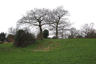
Allesley Castle is a former motte and bailey castle in Allesley, Coventry. The mound has never been excavated. All that remains of the castle is a large mound - the motte - and a defensive ditch approximately 45 metres (148 ft) in diameter. The ditch contains several concrete blocks which are thought to be bases for bridges over the motte. The site is a scheduled historical monument.
