Lincoln is a cathedral city and district in Lincolnshire, England, of which it is the county town. In the 2021 Census, the Lincoln district had a population of 103,813. The 2011 census gave the urban area of Lincoln, including North Hykeham and Waddington, a population of 115,000, a figure which has been updated to 127,540 with the 2021 census.

Lincoln Cathedral, also called Lincoln Minster and formally the Cathedral Church of the Blessed Virgin Mary of Lincoln, is a Church of England cathedral in Lincoln, England. It is the seat of the bishop of Lincoln and the is the mother church for the diocese of Lincoln. The cathedral is governed by its dean and chapter, and is a grade I listed building.

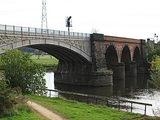
The River Witham is a river almost entirely in the county of Lincolnshire in the east of England. It rises south of Grantham close to South Witham at SK8818, passes through the centre of Grantham, passes Lincoln at SK9771 and at Boston, TF3244, flows into The Haven, a tidal arm of The Wash, near RSPB Frampton Marsh. The name "Witham" seems to be extremely old and of unknown origin. Archaeological and documentary evidence shows the importance of the Witham as a navigable river from the Iron Age onwards. From Roman times it was navigable to Lincoln, from where the Fossdyke was constructed to link it to the River Trent. The mouth of the river moved in 1014 following severe flooding, and Boston became important as a port.

The River Ancholme is a river in Lincolnshire, England, and a tributary of the Humber. It rises at Ancholme Head, a spring just north of the village of Ingham and immediately west of the Roman Road, Ermine Street. It flows east and then north to Bishopbridge west of Market Rasen, where it is joined by the Rase. North of there it flows through the market town of Brigg before draining into the Humber at South Ferriby. It drains a large part of northern Lincolnshire between the Trent and the North Sea.

The Foss Dyke, or Fossdyke, connects the River Trent at Torksey to Lincoln, the county town of Lincolnshire, and may be the oldest canal in England that is still in use. It is usually thought to have been built around AD 120 by the Romans, but there is no consensus among authors. It was refurbished in 1121, during the reign of King Henry I, and responsibility for its maintenance was transferred to the city of Lincoln by King James I. Improvements made in 1671 included a navigable sluice or lock at Torksey, and warehousing and wharves were built at Brayford Pool in the centre of Lincoln.

Coleby is a village and civil parish in the North Kesteven district of Lincolnshire, England. It is situated on the A607, and approximately 6 miles (10 km) south of Lincoln.
The Horncastle Canal was a broad canal which ran 11 miles (18 km) from the River Witham to Horncastle in Lincolnshire, England, through twelve locks largely following the course of the River Bain. The canal opened in 1802, and was abandoned for navigation in 1889.
Temple Bruer Preceptory is a historic building in the civil parish of Temple Bruer with Temple High Grange, North Kesteven, Lincolnshire, England. It is one of the few Knights Templar sites left in England where any ruins remain standing. Its name comes from its Templar ownership and its position in the middle of the Lincoln Heath, bruyère (heather) from the French language current at the time. It was founded in the period 1150 to 1160 and the order was dissolved in 1312. The site is located between the A15 and A607 roads, 2.5 miles (4.0 km) north from Cranwell. The site has been excavated twice, firstly by the Rev Dr. G. Oliver, the rector of Scopwick in 1832–3, and in 1908 by Sir William St John Hope.
Lincolnshire is a large county in England with a sparse population distribution, which leads to problems funding all sorts of transport. The transport history is long and varied, with much of the road network still based on the Roman model, and the once extensive rail network a shadow of its former self.

The Viking Way is a long distance trail in England running 147 miles (237 km) between the Humber Bridge in North Lincolnshire and Oakham in Rutland.
Lindum Colonia was the Roman settlement which is now the City of Lincoln in Lincolnshire. It was founded as a Roman Legionary Fortress during the reign of the Emperor Nero or possibly later. Evidence from Roman tombstones suggests that Lincoln was first garrisoned by the Ninth Legion Hispana, which probably moved from Lincoln to found the fortress at York around c. 71 AD. Lindum was then garrisoned by the Second Legion Adiutrix, which then went on to Chester in 77–78 AD.
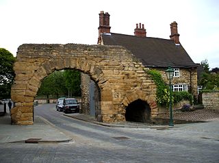
Newport Arch is a 3rd-century Roman gate in the city of Lincoln, Lincolnshire. It is a Scheduled monument and Grade I listed building and is reputedly the oldest arch in the United Kingdom still used by traffic.

Colsterworth is a village and civil parish in the South Kesteven district of Lincolnshire, England, less than half a mile (0.8 km) west of the A1, about 7 miles (11 km) south of Grantham, and 12 miles (19 km) north-west of Stamford. The village with the hamlet of Woolsthorpe-by-Colsterworth had a recorded population of 1,713 at the time of the 2011 census, in an area of 1,465 hectares.

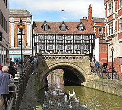
High Street in Lincoln, England extends from the St Catherine's roundabout and ends approximately 1.2 miles further north at The Strait. The historic High Street has evolved through many changes over its 2000 year history, encompassing Roman roads and settlement, medieval buildings, markets, places of worship, civic buildings, bridges, the arrival of the railways and heavy industry.

English Gothic is an architectural style that flourished from the late 12th until the mid-17th century. The style was most prominently used in the construction of cathedrals and churches. Gothic architecture's defining features are pointed arches, rib vaults, buttresses, and extensive use of stained glass. Combined, these features allowed the creation of buildings of unprecedented height and grandeur, filled with light from large stained glass windows. Important examples include Westminster Abbey, Canterbury Cathedral and Salisbury Cathedral. The Gothic style endured in England much longer than in Continental Europe.
The Witham Navigable Drains are located in Lincolnshire, England, and are part of a much larger drainage system managed by the Witham Fourth District Internal Drainage Board. The Witham Fourth District comprises the East Fen and West Fen, to the north of Boston, which together cover an area of 97 square miles (250 km2). In total there are over 438 miles (705 km) of drainage ditches, of which under 60 miles (97 km) are navigable. Navigation is normally only possible in the summer months, as the drains are maintained at a lower level in winter, and are subject to sudden changes in level as a result of their primary drainage function, which can leave boats stranded. Access to the drains is from the River Witham at Anton's Gowt Lock.
Rectory Junction Viaduct, also known as the Radcliffe Viaduct, crosses the River Trent between Netherfield and Radcliffe on Trent near Nottingham. It is a Grade II listed building.

James Sandby Padley was an English surveyor, architect and civil engineer who worked in Lincoln, England. He was county surveyor for the Parts of Lindsey, Lincolnshire from 1825 to 1881, and was also noted for his interest in antiquarian studies.
Langrick Bridge is a village in the civil parish of Holland Fen with Brothertoft in the Borough of Boston, Lincolnshire, England. The village is in the Lincolnshire Fens, 5 miles (8 km) north-west of Boston and 24 miles (40 km) south-east of Lincoln. It is at the southern side of the bridge of the same name which spans the River Witham. At the north side of the bridge the settlement is in the civil parish of Langriville. The southern boundary of the village of Langrick is 200 yards (180 m) north from the bridge.

Lincoln City Centre is the central business district of Lincoln in Lincolnshire, England. It is defined as the areas along directly north of city's High Street. Each part of the centre brings a differing main sector or sectors to the city with a small overlap between each area.