
The Missouri River is a river in the Central and Mountain West regions of the United States. The nation's longest, it rises in the eastern Centennial Mountains of the Bitterroot Range of the Rocky Mountains of southwestern Montana, then flows east and south for 2,341 miles (3,767 km) before entering the Mississippi River north of St. Louis, Missouri. The river drains semi-arid watershed of more than 500,000 square miles (1,300,000 km2), which includes parts of ten U.S. states and two Canadian provinces. Although a tributary of the Mississippi, the Missouri River is slightly longer and carries a comparable volume of water. When combined with the lower Mississippi River, it forms the world's fourth-longest river system.

The Great Plains, sometimes simply "the Plains", is a broad expanse of flatland in North America. It is located just to the east of the Rocky Mountains, much of it covered in prairie, steppe, and grassland. It is the western part of the Interior Plains, which also include the mixed grass prairie, the tallgrass prairie between the Great Lakes and Appalachian Plateau, and the Taiga Plains and Boreal Plains ecozones in Northern Canada. Great Plains or Western Plains is also used to describe the ecoregion of the Great Plains, or alternatively the western portion of the Great Plains.

The Ogallala Aquifer is a shallow water table aquifer surrounded by sand, silt, clay, and gravel located beneath the Great Plains in the United States. As one of the world's largest aquifers, it underlies an area of approximately 174,000 sq mi (450,000 km2) in portions of eight states. It was named in 1898 by geologist N. H. Darton from its type locality near the town of Ogallala, Nebraska. The aquifer is part of the High Plains Aquifer System, and resides in the Ogallala Formation, which is the principal geologic unit underlying 80% of the High Plains.

The following table lists the highest and lowest temperatures recorded in the 50 U.S. states, the District of Columbia, and the 5 inhabited U.S. territories during the past two centuries, in both Fahrenheit and Celsius. If two dates have the same temperature record, only the most recent date is shown.

The United States National Climatic Data Center (NCDC), previously known as the National Weather Records Center (NWRC), in Asheville, North Carolina, was the world's largest active archive of weather data.

The Kansas Geological Survey (KGS) is a research and service division of the University of Kansas, charged by statute with studying and providing information on the geologic resources of Kansas. The KGS has no regulatory authority and does not take positions on natural resource issues.
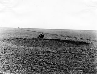
The High Plains are a subregion of the Great Plains, mainly in the Western United States, but also partly in the Midwest states of Nebraska, Kansas, and South Dakota, generally encompassing the western part of the Great Plains before the region reaches the Rocky Mountains. The High Plains are located in eastern Montana, southeastern Wyoming, southwestern South Dakota, western Nebraska, eastern Colorado, western Kansas, eastern New Mexico, the Oklahoma Panhandle, and the Texas Panhandle. The southern region of the Western High Plains ecology region contains the geological formation known as Llano Estacado which can be seen from a short distance or on satellite maps. From east to west, the High Plains rise in elevation from around 1,800 to 7,000 ft.

The geography of the U.S. State of Colorado is diverse, encompassing both rugged mountainous terrain, vast plains, desert lands, desert canyons, and mesas. Colorado is a landlocked U.S. state. In 1861, the United States Congress defined the boundaries of the new Territory of Colorado exclusively by lines of latitude and longitude, stretching from 37°N to 41°N latitude, and from 102°02'48"W to 109°02'48"W longitude. Starting in 1868, official surveys demarcated the boundaries, deviating from the parallels and meridians in several places. Later surveys attempted to correct some of these mistakes but in 1925 the U.S. Supreme Court affirmed that the earlier demarcation was the official boundary. The borders of Colorado are now officially defined by 697 boundary markers connected by straight boundary lines. Colorado, Wyoming, and Utah are the only states that have their borders defined solely by straight boundary lines with no natural features. The southwest corner of Colorado is the Four Corners Monument at 36°59'56"N, 109°2'43"W. This is the only place in the United States where four states meet: Colorado, New Mexico, Arizona, and Utah.

National Ecological Observatory Network (NEON) is a large facility program operated by Battelle Memorial Institute and funded by the National Science Foundation. In full operation since 2019, NEON gathers and provides long-term, standardized data on ecological responses of the biosphere to changes in land use and climate, and on feedback with the geosphere, hydrosphere, and atmosphere. NEON is a continental-scale research platform for understanding how and why our ecosystems are changing.
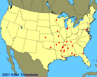
This page documents notable tornadoes and tornado outbreaks worldwide in 2001. Strong and destructive tornadoes form most frequently in the United States, Bangladesh, and Eastern India, but they can occur almost anywhere under the right conditions. Tornadoes also develop occasionally in southern Canada during the Northern Hemisphere's summer and somewhat regularly at other times of the year across Europe, Asia, and Australia. Tornadic events are often accompanied with other forms of severe weather, including strong thunderstorms, strong winds, and hail.

The tornado outbreak of March 28–31, 2007, also known as the Late-March 2007 tornado outbreak, was a tornado outbreak that took place across the central United States. It developed in the High Plains from South Dakota to central Texas on March 28, 2007, which produced most of the tornadoes. Several more tornadoes were reported the next three days before the system weakened on March 31. It affected western Nebraska, western Kansas, extreme eastern Colorado, and much of Oklahoma, and Texas. It was the second major outbreak of 2007, four weeks after an outbreak farther east. The outbreak produced 80 confirmed tornadoes, with five deaths and extensive damage being reported. In addition to the tornadoes, widespread hail as large as softballs and destructive straight-line winds as strong as 90 mph (140 km/h) were reported.

The Dakota is a sedimentary geologic unit name of formation and group rank in Midwestern North America. The Dakota units are generally composed of sandstones, mudstones, clays, and shales deposited in the Mid-Cretaceous opening of the Western Interior Seaway. The usage of the name Dakota for this particular Albian-Cenomanian strata is exceptionally widespread; from British Columbia and Alberta to Montana and Wisconsin to Colorado and Kansas to Utah and Arizona. It is famous for producing massive colorful rock formations in the Rocky Mountains and the Great Plains of the United States, and for preserving both dinosaur footprints and early deciduous tree leaves.
From May 4–6, 2007, a major and damaging tornado outbreak significantly affected portions of the Central United States. The most destructive tornado in the outbreak occurred on the evening of May 4 in western Kansas, where about 95% of the city of Greensburg in Kiowa County was destroyed by an EF5 tornado, the first of such intensity since the 1999 Bridge Creek–Moore tornado. The supercell killed 13 people, including 11 in Greensburg and two from separate tornadoes. At least 60 people were injured in Greensburg alone. It was the strongest tornado of an outbreak which included several other tornadoes reported across Oklahoma, Colorado, Kansas and South Dakota that occurred on the same night.

The Late-May 2010 tornado outbreak was a tornado outbreak that begun on May 22, 2010, and ended May 25. The storm system responsible for the tornadoes affected a large area from North Dakota to New Mexico. The system that caused the outbreak formed from a low-pressure system that was located in Canada.

The tornado outbreak sequence of May 5–10, 2015 was a six-day outbreak of tornado activity that affected the Great Plains of the United States in early May 2015. On May 6, strong tornadoes impacted the Oklahoma City area, along with rural parts of Kansas, Texas, Arkansas, South Dakota, and Nebraska. The outbreak coincided with major flooding, with large amounts of rain falling in parts of Nebraska, Kansas, Oklahoma, and Texas. The National Weather Service forecast office in Norman, Oklahoma issued a "flash flood emergency" for Oklahoma City following record-breaking rainfall that occurred in the area that evening. The outbreak sequence resulted in five tornado-related deaths, along with two flood-related deaths. A total of 127 tornadoes were confirmed and rated as a result of this outbreak sequence. Damage from the outbreak was estimated at $1.5 billion.
The National Centers for Environmental Information (NCEI) is a U.S. government agency that manages one of the world's largest archives of atmospheric, coastal, geophysical, and oceanic data. The current director is Derek Arndt.

A deadly and destructive outbreak sequence of 23 tornadoes struck parts of the Great Plains and the Great Lakes in late-June 1957. At least seven significant tornadoes (F2+) touched down during the outbreak sequence. The most devastating storm was a large, violent, and catastrophic 500-yard-wide F5 tornado family that struck Fargo, North Dakota on Thursday, June 20, 1957, killing 10 people and becoming the deadliest tornado ever recorded in North Dakota. The outbreak caused 11 fatalities, 105 injuries, and $25.883 million in damage.

