
Hawarden is a village, community and electoral ward in Flintshire, Wales. It is part of the Deeside conurbation on the Wales-England border and is home to Hawarden Castle. In the 2011 census the ward of the same name had a population of 1,887, whereas the community of the same name, which also includes Ewloe Mancot and Aston had a population of 13,920. The scenic wooded Hawarden Park abuts the clustered settlement in the south. Hawarden Bridge consists of distribution and industrial business premises beyond Shotton/Queensferry and the Dee. The west of the main street is called The Highway, its start marked by the crossroads with a fountain in the middle, near which are public houses, some with restaurants.
Tattenhall is a village and former civil parish, now in the parish of Tattenhall and District, 8 miles (13 km) south-east of Chester, in the unitary authority of Cheshire West and Chester and the ceremonial county of Cheshire, England. In the 2001 census, the population was recorded as 1,986, increasing to 2,079 by the 2011 census. The civil parish was abolished in 2015 to form Tattenhall and District.

Holywell is a market town and community in Flintshire, Wales. It lies to the west of the estuary of the River Dee. The community includes Greenfield.

Mostyn is a village and community in Flintshire, Wales, and electoral ward lying on the estuary of the River Dee, located near the town of Holywell. It has a privately owned port that has in the past had a colliery and ironworks and was involved in the export of commodities, and in present times services the offshore wind industry and ships the wings for the Airbus A380 which are manufactured at Broughton.

Shotton is a town and community in Flintshire, Wales, within the Deeside conurbation along the River Dee, joined with Connah's Quay, near the border with England. It is located 5 miles (8 km) west of Chester and can be reached by road from the A548. In the 2011 census Shotton had a population of 6,663. The Ordnance Survey Grid Reference is SJ305685.

Saltney is a cross-border town, split between Flintshire, Wales and Cheshire, England. The town is intersected by the England–Wales border, with its larger part being a community of Wales in the historic county of Clwyd. The town forms part of Chester's built-up area and is around 5 miles from Deeside.
Bolton-le-Sands is a large village and civil parish of the City of Lancaster in Lancashire, England. The parish had a population of 4,098 recorded in the 2001 census, increasing to 4,127 at the 2011 Census.

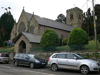
Ewloe is a village and electoral ward in the community of Hawarden in Flintshire, Wales. It is situated close to the Flintshire/Cheshire sector of the Wales-England border. The A55 expressway passes through Ewloe and its most notable landmark is Ewloe Castle. The Ewloe electoral ward had a population at the 2011 Census of 5,420. The urban area of the village is contiguous with Hawarden, Buckley and Shotton. The Office for National Statistics deems Ewloe to form part of the Buckley built-up area, which covers much of Deeside.

Alyn and Deeside is a parliamentary constituency represented in the House of Commons of the Parliament of the United Kingdom. The constituency was created in 1983, and it elects one Member of Parliament (MP) by the first-past-the-post method of election.

Flintshire County Council is the unitary local authority for the county of Flintshire, one of the principal areas of Wales. It is based at County Hall in Mold.

Shap is a village and civil parish located among fells and isolated dales in Westmorland and Furness, Cumbria, England. The village is in the historic county of Westmorland. The parish had a population of 1,221 in 2001, increasing slightly to 1,264 at the 2011 Census.

Hope is a small village and community in Flintshire, north-east Wales. The village is located approximately 3 miles / 4.5 km from the Wales-England border, on the course of the River Alyn, and less than 5 miles from Wrexham.

Treuddyn is a village, community and electoral ward in Flintshire, Wales, located just off the A5104 road, around 4 miles south-east of Mold and 3 miles north-west of Caergwrle. The community includes the nearby village of Coed Talon, to the east, and Rhydtalog, to the south-west on the Denbighshire border.
Mancot is a village in Flintshire, Wales, approximately 1 mile from Queensferry, and Hawarden and 6 miles from Chester. According to the 2001 Census, Mancot had a population of 3,462. In 1849 the population of the village was 282.
Rossett is a village, community and electoral ward in Wrexham County Borough, Wales. Rossett is served by the A483 road.
Whitford is a village, community and an electoral ward near Holywell in Flintshire, northeast Wales. The population of both the community and the ward taken at the 2011 census was 2,332. The community includes the villages of Carmel, Lloc, Gorsedd and Pantasaph.

Dodleston is a village and civil parish in the unitary authority of Cheshire West and Chester and the ceremonial county of Cheshire, England. The village is situated to the south west of Chester, very close to the England–Wales border. The civil parish includes Balderton, Gorstella, Lower Kinnerton and Rough Hill. It is one of the three old Cheshire parishes which are situated on the Flintshire side of the River Dee.

Lower Kinnerton is a village and former civil parish, now in the parish of Dodleston, in the unitary authority of Cheshire West and Chester and the ceremonial county of Cheshire, England, close to the England–Wales border. The neighbouring village of Higher Kinnerton is across the border in Flintshire. Lower Kinnerton is south of Broughton and to the north west of the village of Dodleston. It is a small agricultural community, which is also home to a local kennel and cattery business.

Llanfynydd is a village, local government community and electoral ward in Flintshire, Wales. Its name is derived from the Welsh words llan, and mynydd ("mountain").

Old Radnor is a village and community in Powys, Wales. The community includes Old Radnor and the villages of Yardro, Dolyhir, Burlingjobb, Evenjobb, Kinnerton and Walton. In the 2001 census and the 2011 Census the community had a population of 741 in 323 households. Old Radnor lies on a lane off the A44 to the west of the Wales–England border.


