M01 is a Ukrainian international highway (M-highway) that stretches from the state capital, Kyiv, to the northern border with Belarus.
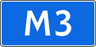
The Russian route M3 is a major trunk road that runs across a distance of about 490 kilometres from Moscow to Russia's border with Ukraine.

Highway M04 was a Ukraine international highway connecting Znamianka to Sorokyne on the border with Russia, where it continued into Russia as the A260.
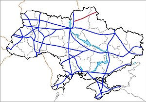
State highways in Ukraine are subdivided into four categories: international (M-network), national (H-network), regional (P-network), and territorial (Т-network). The letter's indexes are in Cyrillic, standing for their respective abbreviations in Ukrainian.

Highway M03 is a Ukrainian international highway (M-highway) connecting Kyiv with Dovzhansky on the border with Russia, where it continues into Russia as the A270. It is part of European route E40 from Kyiv to Debaltseve at which it is part of European route E50 to the border with Russia. At 844 km (524 mi), the M03 is the longest international state highway in Ukraine.

Highway M07 is a Ukrainian international highway (M-highway) connecting Kyiv to Yahodyn on the border with Poland, where it continues into Poland as National Road 12 (DK12).

Highway M09 is a Ukrainian international highway (M-highway) which is part of the Warsaw - Lviv route. It starts as a split-off from the M12 near Ternopil, runs through Lviv, then turns north and heads towards the border with Poland. The highway terminates at the border checkpoint Rava-Ruska. Across the Polish border it continues as National Road 17 (DK17). The entire route is part of European route E372.

M12 was a Ukrainian international highway (M-highway) connecting Lviv Oblast to Central Ukraine, where after crossing the Dnieper it continued further as the M04. On 28 April 2021, the M12 was decommissioned and merged with the M04 to form the new M30.

Highway M20 is the second shortest Ukraine international highway (M-highway) which connects Kharkiv to the border with Russia at Hoptivka in Kharkiv Raion in Kharkiv Oblast (Kharkivshchyna) and Nehoteevka in Belgorodsky Raion in Belgorodskaya Oblast. The section from Lisne to the Russian border is part of European route E105, known as the Crimea Highway in Russia.

Highway M16 is a Ukrainian international highway (M-highway) connecting Odesa to Kuchurhan on the border with Moldova, where it continues as national road M5. The M16 is part of European route E58 and European route E581.

Highway M19 is a Ukrainian international highway (M-highway) that completely corresponds to whole length of European route E85 that runs through Ukraine.

Road P-65 is a highway of regional significance in Ukraine. It connects two border crossings between Russia and Ukraine, "Mykolaivka" and "Katerinovka". The road passes through the Chernihiv and Sumy regions and goes across Semenivka, Novhorod-Siverskyi, Shostka and Hlukhiv.
European route E 38 (E 38) is a west–east European route, running from Hlukhiv in Ukraine to Shymkent in Kazakhstan. In Ukraine, the highway runs from the intersection with European route E 101, through Hlukhiv to the Russian border near Katerynivka.
European route E 40 (E 40) is a west–east European route, running from the port of Calais in France to Altai Mountains near Ridder in Kazakhstan.
Ponornytsia is a rural settlement in Novhorod-Siverskyi Raion, Chernihiv Oblast, northern Ukraine. It hosts the administration of Ponornytsia settlement hromada, one of the hromadas of Ukraine. Population: 1,931.
P44 is a regional Ukraine road (P-highway) in Sumy Oblast, Ukraine, half of it running mainly north-south and the other half at an angle. It connects Hlukhiv with Sumy. It begins at Highway P61 and Bilopilskiy Shlyakh in Sumy and passes through Postolne, Synyak, Barylo, Peremoha, Bilopillya, Vorozhba, Pisky, Klepaly, Ihorivka, Chumakove, Zinove, Putivl, Bobyne, Vyazenka, Banychi, and Peremoha, and ends in Hlukhiv at the intersection of Tereschenkiv Street and Kyievo-Moskovska Street.
P46 is a regional Ukraine road (P-highway) in Sumy Oblast and Kharkiv Oblast, Ukraine, running mainly west–east and connecting Okhtyrka with Kharkiv in a more or less straight line. It begins at Highway H12 in Okhtyrka and passes through Khodunaivka, Kupjevakha, Hubarivka, Bohodukhiv, Musiyki, Krysynska, Maksymivka, Horkoho, Vilshany, Dvorichnyi Kut, Peresichne, Solonytsivka, Podvirky, and finally arrives to the Kholodnohirsk District of Kharkiv at Zalyutynska Street and Poltavskyi Shlyakh Street.
Esman is an urban-type settlement in Shostka Raion, Sumy Oblast, Ukraine. It is located on the left bank of the Esman river, a right tributary of the Kleven, in the drainage basin of the Dnieper. Esman hosts the administration of Esman settlement hromada, one of the hromadas of Ukraine. Population: 1,293.
Shalyhyne is an urban-type settlement in Shostka Raion, Sumy Oblast, Ukraine. It is located on the banks of the Lapuha, a left tributary of the Kleven, in the drainage basin of the Dnieper. Shalyhyne hosts the administration of Shalyhyne settlement hromada, one of the hromadas of Ukraine. Population: 2,226.

The battle of Hlukhiv was a series of clashes that began on February 24, 2022, in the town of Hlukhiv, Hlukhiv Raion, Sumy Oblast, as part of the Russian invasion of Ukraine in 2022.