Hillsborough Street

Last updated
Hillsborough Street Hillsborough Street in Downtown Raleigh.jpg
Hillsborough Street

Hillsborough Street is a business and cultural thoroughfare through Raleigh, North Carolina, United States. The street serves as a center for social life among North Carolina State University and Meredith College students.

Contents

Bars, restaurants, coffee shops, convenience stores and banks are located along a strip of Hillsborough Street that borders the university. The road is also a busy transport corridor, linking the town of Cary with downtown Raleigh. Additionally, the road passes by the North Carolina State Veterinarian School, North Carolina State University Centennial Biomedical Campus, the North Carolina State Fairgrounds, Sacred Heart Church, and Raleigh's Pullen Park.

Hillsborough Street in Raleigh Hillsborough Street in Raleigh, NC.jpg
Hillsborough Street in Raleigh

Route description

Hillsborough Street begins at the Cary/Raleigh line in west Raleigh as a continuation of Chatham Street. Traveling east closely alongside the CSX railroad tracks it passes through a mixed-use area with small industries, older neighborhoods, and restaurants and other small businesses alongside the road. At about 1.2 miles (1.9 km), the roadway splits as Hillsborough Street meets Western Boulevard; Hillsborough Street follows the westbound lanes and Western follows the eastbound lanes. This arrangement continues for about 0.5 miles (0.80 km), at the middle of which is the northern terminus of Jones Franklin Road. Hillsborough Street turns off the roadway on a two-way road due north, while Western Boulevard continues east on the same roadway.

After 0.5 miles (0.80 km) Hillsborough Street merges on to NC 54 (west of this interchange, NC 54 continues as Chapel Hill Street), and turns east, now on the opposite side of the CSX tracks. The road passes the North Carolina State Fairgrounds and the North Carolina State University College of Veterinary Medicine before an interchange with Interstate 440 (exit 4 on I-440), at which NC 54 reaches its eastern terminus. After I-440 the road passes to the south of the main entrance of Meredith College. After an intersection with Faircloth Street and Gorman Street, the roadway passes through a small commercial district with restaurants and small shops before entering the main campus of North Carolina State University, crossing Dan Allen Drive. Commercial buildings continue on the north side of the street, while several campus buildings line the right side, dominated by the main tower of the D.H. Hill Library. The route through campus features a wide, pedestrian-friendly median and several traffic circles that serve as traffic calming devices. At the east end of campus is a larger traffic circle that serves as the intersection between Hillsborough Street, Pullen Road, and Oberlin Road, just to the south of this lies the North Carolina State University Memorial Bell Tower. Leaving campus, the road passes through a medium density residential district, with townhouses lining the street. There's a traffic circle with Morgan Street as the road passes by Saint Mary's School, before entering Downtown Raleigh.

At Glenwood Avenue the road splits into two one-way streets, with Hillsborough Street continuing eastbound, and Edenton Street westbound. Within downtown, the road passes by a number of new high-rise office buildings, interspersed with older businesses, such as restaurants and hotels. Sacred Heart Church, the former cathedral for the Roman Catholic Diocese of Raleigh, lies on the north side of the road in between the one-way Dawson and McDowell Streets, which carry US 401, US 70, and NC 50, while on the south side of the same block is the Norman Adrian Wiggins School of Law. First Baptist Church lies on the north side of the next block, just as Hillsborough Street reaches its western terminus at Salisbury Street, facing the west façade of the North Carolina State Capitol.

History

Hillsborough Street takes its name from the city Hillsborough, a former capital city of North Carolina. Like many downtown Raleigh streets, the street's name is derived from a city of the same name in the state; though, initially the street was named Hillsboro Road and was a country road many people used to drive to Hillsborough. [1] The street was first constructed in 1792 as part of the capital city's initial layout. [2]

The land comprising Hillsborough Street was once the site of the plantation of David Cameron. Cameron established St. Mary's College on Hillsborough Street; the school later became a private girls' school, St. Mary's School. [1] A streetcar traversing Hillsborough Street connected North Carolina State University to Raleigh shortly after the college was built. [1]

The street was the site of North Carolina's largest anti-Vietnam War marches, with 10,000 people, including UNC and Duke students, protesting the war. [1]

Places of worship

Hillsborough Street historic churches include:

Special events

Basketball and football victories

Following every football and basketball win the NCSU Bell Tower is illuminated red and students are encouraged to "Storm the Bell Tower" and show their Wolfpack pride. After the NC State men's basketball team won the national championship in 1983, students converged on Hillsborough Street to celebrate, with at least one injury to a police officer. [1] Subsequently, the police department cracked down on problem bars on Hillsborough Street, which resulted in many bar closures. The closures included seven bars located at Hillsborough Square. [1]

Paint the Town Red and NCSU Homecoming

As part of NCSU's homecoming week since 2006, many businesses along Hillsborough Street agree to have groups of NCSU students paint their windows red, the main athletic color of the NC State Wolfpack. [3] The spectacle was deemed "Paint the Town Red". Each year, alumni, students, faculty and staff as well as Wolfpack faithful fill the NC State Campus and surrounding areas painting the town red. Onlookers congregate on Hillsborough Street for the annual Homecoming Parade and watch as dozens of school floats make their way towards the Bell Tower.

WRAL-TV Raleigh Christmas Parade

A Christmas parade is held along Hillsborough Street among other Raleigh streets every November. The event, sponsored by WRAL-TV attracts Raleighites, NCSU students, and visitors. [4]

Krispy Kreme Challenge

The Krispy Kreme Challenge, a race invented and organized by NC State Park Scholars with a majority of runners attending NC State, is a new NC State tradition which attracted over 7,500 runners in 2010. Part of Hillsborough Street is closed in order for runners to make their way from the NC State Bell Tower to the Krispy Kreme on Peace Street. The objective is to run to the Krispy Kreme, eat one dozen doughnuts, and run back to the Bell Tower in under one hour. The event raises money to support the North Carolina Children's Hospital, and in 2010 raised $122 million.

City of Oaks Marathon

The Raleigh City of Oaks Marathon and Rex Healthcare Half Marathon annually attracts thousands of athletes to the capital city. The course is revered for the diversity of the landscape, showcasing the Triangle’s natural areas and the capital’s history.

Susan G. Komen Race for the Cure

The Komen NC Triangle Race for the Cure, hosted at Meredith College, raises funds and awareness for the fight against breast cancer, celebrates breast cancer survivorship, and honors those who have lost their battle with the disease. All net funds from the Komen Race for the Cure go to research, education, screening and treatment programs.

9/11 Memorial Service

On the tenth anniversary of September 11, 2001 NC State Chancellor Randy Woodson lead the campus and community in a memorial service at the Bell Tower honoring all those who perished in the events of 9/11. The service paid tribute to all NCSU alumni who have served in the military. To coincide with this event, the Hillsborough Street Community Service Corporation enlisted the help of over 35 NCSU student groups and organizations to decorate the store-fronts on Hillsborough Street with patriotic imagery. These groups volunteered their time to show their support for, and appreciation of, all the first responders and citizens who lost their lives on that day in 2001. They also thanked all the troops who have served and continue to serve the USA in the armed services.

Art to Wear

Art to Wear is an annual fashion show featuring the creations of NC State students. The NCSU College of Design and College of Textiles team together to showcase the young talent that can be found at NC State as well as its connectivity to the clothing design merchants found around Raleigh, NC. The event is normally followed by an after event which fills the local establishments with customers long into the night.

Notable businesses

One notable business on Hillsborough Street is Players' Retreat, a saloon that opened more than 50 years ago. [1] The bar encompasses a former restaurant, the Morning Room, which served as the unofficial headquarters of Hargrove Bowles' 1972 gubernatorial campaign against Jim Holshauser. It was also a hangout of the Wolfpack basketball players, of Norman Sloan, in the 1970s. [1] Mitch's Tavern was used for scenes in the film Bull Durham in the 1980s. [1] The publishing company Lulu is headquartered on Hillsborough Street. [1]

Education institutions

There are four major education institutions located on Hillsborough Street. The first, and largest, of these is North Carolina State University, with over 34,000 students, and 6,000 faculty and staff. Meredith College is located on the street, with approximately 2,200 female students and 138 faculty members, Meredith College has grown to become one of the largest independent private women’s college in the United States. The third education institution is the all-girls boarding and day school St. Mary’s School for grades 9-12. Norman Adrian Wiggins School of Law of Campbell University lies near the eastern terminus of the street.

Hillsborough Street Community Service Corporation

The Hillsborough Street Community Service Corporation is an independent, not for profit, business improvement district created by a partnership between the City of Raleigh, NC State University and the property owners and businesses on Hillsborough Street in the fall of 2009. The HSCSC territory is about 2.5 miles long running on both sides of Hillsborough Street from St. Mary’s School to the beltline (including Morgan St. and a few side streets) and includes a collection of businesses, organizations, institutions and residential options.

The corporation’s mission is to make the Hillsborough Street community a destination in Raleigh by providing services and programs that improve the economic sustainability of the businesses, and increases the market value of the properties.

Related Research Articles

Raleigh, North Carolina Capital city of North Carolina, United States

Raleigh is the capital of the state of North Carolina and the seat of Wake County in the United States. It is the second-most populous city in North Carolina, the 41st-most populous city in the U.S., and the largest city of the Research Triangle metro area. Raleigh is known as the "City of Oaks" for its many oak trees, which line the streets in the heart of the city. The city covers a land area of 147.6 square miles (382 km2). The U.S. Census Bureau counted the city's population as 474,069 in 2020. It is one of the fastest-growing cities in the country. The city of Raleigh is named after Walter Raleigh, who established the lost Roanoke Colony in present-day Dare County.

North Carolina State University Public university in Raleigh, North Carolina, United States

North Carolina State University is a public land-grant research university in Raleigh, North Carolina. Founded in 1887 and part of the University of North Carolina system, it is the largest university in the Carolinas. The university forms one of the corners of the Research Triangle together with Duke University in Durham and the University of North Carolina at Chapel Hill. It is classified among "R1: Doctoral Universities – Very high research activity".

Meredith College Private liberal arts womens college in Raleigh, North Carolina, United States

Meredith College is a women's liberal arts college and coeducational graduate school in Raleigh, North Carolina. As of 2021 Meredith enrolls approximately 1,500 women in its undergraduate programs and 300 men and women in its graduate programs.

Carter–Finley Stadium Stadium in Raleigh, North Carolina

Wayne Day Family Field at Carter–Finley Stadium is home to the NC State Wolfpack football team. It was opened in 1966 and has grown to a seating capacity of 58,000 seats.

Reynolds Coliseum

William Neal Reynolds Coliseum is a multi-purpose arena located in Raleigh, North Carolina, United States, on the campus of North Carolina State University. The arena was built to host a variety of events, including agricultural expositions and NC State basketball games. It is now home to all services of ROTC and several Wolfpack teams, including women's basketball, women's volleyball, women's gymnastics, and men's wrestling. The university named the court in Reynolds "Kay Yow Court" on February 16, 2007 with the assistance of a substantial donation from the Wolfpack Club. That same night, the Wolfpack women upset #2 North Carolina, just two weeks after the men upset #3 North Carolina at the PNC Arena.

Pullen Park Park in Raleigh, North Carolina

Pullen Park is a 66.4-acre (0.27 km2) public park immediately west of downtown Raleigh, North Carolina. It is located on Ashe Avenue and is adjacent to the Main and Centennial campuses of North Carolina State University, covering an area between Western Boulevard and historic Hillsborough Street. Founded in 1887, Pullen Park is the oldest public park in North Carolina.

Interstate 440 (I-440), also known as the Raleigh Beltline, the Cliff Benson Beltline, or locally as The Beltline, is an Interstate Highway in the US state of North Carolina. I-440 is a 16.4-mile-long (26.4 km) partial beltway that nearly encircles central Raleigh. I-440 begins in west Raleigh at an interchange with I-40 as a continuation of U.S. Highway 64 (US 64)/US 1 and traverses a primarily residential area in west Raleigh. The freeway makes a turn toward the east, crossing US 70, Six Forks Road, and Wake Forest Road. US 1 branches north off I-440 at US 401, becoming US 401/US 1. I-440 turns toward the southeast and follows a brief concurrency with U.S. Highway 64 Business before intersecting I-87/US 64/US 264. US 64 and I-87 are concurrent with I-440 along the remainder of the road's southwesterly routing. Exit 16 is the last exit on I-440, where I-440 splits to join either I-40 eastbound and westbound.

North Carolina Highway 67 (NC 67) is a 40.9-mile-long (65.8 km) primary state highway in the U.S. state of North Carolina. NC 67 travels through Yadkin County and Forsyth County between its western terminus at U.S. Route 21 Business in Jonesville and NC 150 in Winston-Salem. The highway primarily follows an east–west alignment and connects the towns of Jonesville, Boonville, and East Bend, along with the city of Winston-Salem.

Riddick Stadium was a college football stadium in Raleigh, North Carolina, and home to the North Carolina State University Wolfpack football team. When the stadium was first opened, it was referred to as New Athletic Park. Later it was named Riddick Field and then Riddick Stadium, after W. C. Riddick, N.C. State football coach during the 1898 and 1899 seasons. The Wolfpack baseball team also played its home games in the stadium prior to moving to Doak Field.

Doak Field Baseball venue in Raleigh, North Carolina

Doak Field is a baseball venue in Raleigh, North Carolina, United States. It opened in 1966 and is home to the North Carolina State University Wolfpack college baseball team of the NCAA's Division I Atlantic Coast Conference (ACC). It is named for Charles Doak, who was the head coach of the NC State baseball team from 1924–1939. The stadium is located on NC State's West Campus, behind Lee and Sullivan residence halls. The diamond is in the north/northwest corner of its block, which is bounded by Thurman Drive ; Dail Park and the residence halls ; Sullivan Drive ; and Varsity Drive. Its seating capacity is 2,500 spectators, with an overflow capacity of 3,000. The largest crowd at Doak Field since its 2004 renovation was 3,109 on April 28, 2007, in a series finale between NC State and its rival UNC. Doak Field hosted the Atlantic Coast Conference Baseball Tournament in both 1974 and in 1980. NC State won the championship in 1974, while Clemson won in 1980.

North Carolina State University was founded by the North Carolina General Assembly in 1887 as a land-grant college under the name North Carolina College of Agriculture and Mechanic Arts. As a land-grant college, NC State would provide a "liberal and practical education" while focusing on military tactics, agriculture and the mechanical arts without excluding classical studies. Since its founding, the university has maintained these objectives while building on them.

North Carolina Highway 54 State highway in North Carolina, US

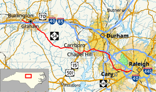
North Carolina Highway 54 (NC 54) is a 55.0-mile-long (88.5 km) primary state highway in the U.S. state of North Carolina. The highway serves the Research Triangle area, between Burlington and Raleigh, connecting the cities and towns of Chapel Hill, Durham, Morrisville and Cary. The highway also links the campuses of University of North Carolina at Chapel Hill and North Carolina State University.

NC State Wolfpack Intercollegiate sports teams of North Carolina State University

The NC State Wolfpack is the nickname of the athletic teams representing North Carolina State University. The Wolfpack competes at the National Collegiate Athletic Association (NCAA) Division I as a member of the Atlantic Coast Conference (ACC) for all sports since the 1953–54 season. The athletic teams of the Wolfpack compete in 23 intercollegiate varsity sports. NC State is a founding member of the ACC and has won nine national championships: three NCAA championships, two AIAW championships, and four titles under other sanctioning bodies. Most NC State fans and athletes recognize the rivalry with the North Carolina Tar Heels as their biggest.

NC State Wolfpack football College Football Bowl Subdivision team; member of Atlantic Coast Conference

The NC State Wolfpack football team represents North Carolina State University in the sport of American football. The Wolfpack competes in the NCAA Division I Football Bowl Subdivision (FBS) of the National Collegiate Athletic Association (NCAA) and the Atlantic Division of the Atlantic Coast Conference (ACC). Prior to joining the ACC in 1953, the Wolfpack were a member of the Southern Conference. As a founding member of the ACC, the Wolfpack has won seven conference championships and participated in 31 bowl games, of which the team has won 17, including eight of their last 11. NC State is coached by Dave Doeren.

Main Campus of North Carolina State University

The Main Campus is the primary campus of North Carolina State University, located in Raleigh, North Carolina, US, inside the Beltline. Notable features of Main Campus include the Bell Tower and D. H. Hill Library. The campus is known for its distinctive red brick buildings, sidewalks, plazas, and sculptures; some are dotted with decorative brick mosaics. University Plaza is nicknamed "The Brickyard" because it is mostly a flat, open, bricked area.

Krispy Kreme Challenge

The Krispy Kreme Challenge is an annual charity event in which participants run a 5 miles (8.0 km) road course leading to a Krispy Kreme Doughnuts shop, eat one dozen doughnuts, and run back to the finish line in under 1 hour. The event began in 2004 and is still planned and executed by Park Scholars at North Carolina State University in Raleigh N.C. Profits from the race are donated to North Carolina Children's Hospital, and the 2018 race brought total donations to over $1.5 million. The Krispy Kreme Challenge is not affiliated with the Krispy Kreme company.

Wolfline

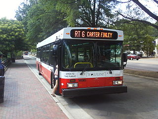
The Wolfline is an area bus service serving the students, staff, faculty, and general public on and around North Carolina State University's campus in Raleigh, North Carolina. As of Fall 2017, Wolfline is operated by Transdev, after being operated by First Transit between 2007 and 2017, under contract with NC State's Transportation department. The Wolfline was the first mass transit organization in the state to exclusively use 'clean' diesel engines. Wolfline access is unrestricted to the public and is a zero-fare service. The preceding contractor was Veolia Transport. The Wolfline began operating in August 1980 with one route.

D. H. Hill Library

The D. H. Hill Jr. Library is the main library at North Carolina State University. It is the third building to house the NC State University Libraries, following Brooks Hall and Holladay Hall. The current building, situated on the Hillsborough Street edge of North Campus, is the result of four stages of construction, and houses the majority of the volumes in NC State's collection.

North Carolina State University Memorial Belltower

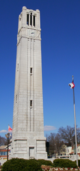
The North Carolina State University Memorial Belltower is a 115-foot-tall (35 m) free-standing bell tower on the Main Campus of North Carolina State University in Raleigh, North Carolina Conceived as a war memorial to honor university alumni killed in World War I and the university's overall participation in the conflict, the Belltower now serves as a perpetual memorial for N.C. State students and alumni who gave their lives in the service of the nation. A prominent university symbol, the tower is a popular rallying point for the campus community.

Dail Soccer Field

The Dail Soccer Field is the on-campus soccer stadium at North Carolina State University in Raleigh, North Carolina.

References

  1. 1 2 3 4 5 6 7 8 9 10 Geary, Bob (2009-05-27). "Keep Hillsborough Street funky". Independent Weekly . Retrieved 2009-06-12.
  2. City of Raleigh - Hillsborough Street Redesign
  3. "Technician Online - Hillsborough Street is seeing red (10-30-2006)". Archived from the original on 2007-09-27. Retrieved 2007-02-24.
  4. WRAL-TV Raleigh Christmas Parade 2005

Coordinates: 35°47′41″N78°41′28″W / 35.7947482°N 78.6911352°W / 35.7947482; -78.6911352