Hipswell

Last updated

Hipswell
St John the Evangelist Church, Hipswell.jpg
St John the Evangelist Church, Hipswell
North Yorkshire UK location map (2023).svg
Red pog.svg
Hipswell
Location within North Yorkshire
Population5,388 (2011 census) [1]
OS grid reference SE183983
Civil parish
Unitary authority
Ceremonial county
Region
Country England
Sovereign state United Kingdom
Post town CATTERICK GARRISON
Postcode district DL9
Dialling code 01748
Police North Yorkshire
Fire North Yorkshire
Ambulance Yorkshire
UK Parliament
List of places
UK
England
Yorkshire
54°22′48″N1°43′08″W / 54.380°N 1.719°W / 54.380; -1.719

Hipswell is a village and civil parish in the North Yorkshire (district) of the county of the same name. The civil parish mainly comprises the northern part of Catterick Garrison. The village of Hipswell is at the eastern end of the civil parish, and effectively forms a suburb of Catterick Garrison.

Contents

History

Hipswell was mentioned in the Domesday Book in 1086 as being in the hundred of "Land of Count Alan" and the county of Yorkshire, the population was estimated at 6 households. [3] In the 1320s it was the birthplace of noted English theologian John Wycliffe, leader of the Lollard Movement.

Hipswell was historically a township in the ancient parish of Catterick in the North Riding of Yorkshire. In 1870-72 John Marius Wilson's Imperial Gazetteer of England and Wales described Hipswell as:

a township and a chapelry in Richmond district, N. R. Yorkshire. The township lies on Rysdale beck, near its influx to the Swale, and near the Richmond railway, 2 miles SE of Richmond; and is in the parish of Catterick. Acres, 2, 785. Real property, £2, 768. Pop., 260. Houses, 53. [4]

Situated close to the church, Hipswell Hall is a 15th-century manor house, with alterations dated 1596 with the initials "GW" for George Wandesford, possibly originally part of a fortified house, built for the Fulthorpe family. [5]

Governance

Hipswell lies within the Richmond (Yorks) parliamentary constituency, which is under the control of the Conservative Party. The current Member of Parliament, since the 2015 general election, is Rishi Sunak. An electoral ward for Richmondshire District Council in the same name exists; this ward stretches north almost to Richmond with a total population taken at the 2011 census of 5,610. [6]

Community and culture

Hipswell Church of England Primary School which caters for nearly 200 pupils, [7] is the local primary education provider, Risedale School is also located in Hipswell, which provides secondary and further education for the surrounding Garrison area. The village hall was originally built in 1919, but was re-erected in 1929 after a fire. [8]

Hipswell Hall Hipswell Hall - geograph.org.uk - 1390356.jpg
Hipswell Hall

Religion

Hipswell ecclesiastical parish is formed by the villages of Hipswell with Colburn and Scotton. Hipswell is served by the church of St. John the Evangelist, Hipswell Road, Hipswell. [9]

Hipswell churchyard was the initial burial ground for soldiers from Catterick Garrison and its Military Hospital in the First World War. It contains the war graves of 64 service personnel from that war and of 2 British soldiers from the Second World War. A screen wall lists those whose graves are not marked by headstones. [10] In 1930, on the churchyard's northern boundary, Catterick Garrison Cemetery was opened by the War Office as a purpose-made cemetery for the camp. This includes war graves of 42 Commonwealth service personnel and some Polish service personnel of the Second World War. A Cross of Sacrifice stands at the boundary of the two burial grounds. [11]

Related Research Articles

<span class="mw-page-title-main">Catterick Garrison</span> Garrison and military town in North Yorkshire, England

Catterick Garrison is a major garrison and military town 3 miles (5 km) south of Richmond, North Yorkshire, England. It is the largest British Army garrison in the world, with a population of around 13,000 in 2017 and covering over 2,400 acres. Under plans announced by the Ministry of Defence (MoD) in November 2005, its population is expected to grow to over 25,000, making it the largest population centre in the local area.

<span class="mw-page-title-main">Colburn, North Yorkshire</span> Town and civil parish in North Yorkshire, England

Colburn is a town, civil parish and electoral ward in North Yorkshire, England, 2 miles (3.2 km) west of Catterick. It had a population of 4,860 at the 2011 census, rising from 3,606 in 2001.

<span class="mw-page-title-main">Catterick, North Yorkshire</span> Village, civil parish and electoral ward in North Yorkshire, England

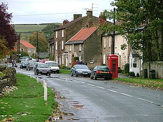
Catterick is a village, civil parish and electoral ward in the Richmondshire district of North Yorkshire, England. Historically part of the North Riding of Yorkshire, it is 8.5 miles (13.7 km) north-west of the county town of Northallerton just to the west of the River Swale. It lends its name to nearby Catterick Garrison and the nearby hamlet of Catterick Bridge, the home of Catterick Racecourse where the village Sunday market is held. It lies on the route of the old Roman road of Dere Street and is the site of the Roman fortification of Cataractonium.

<span class="mw-page-title-main">Dalton, west North Yorkshire</span> Village and civil parish in North Yorkshire, England

Dalton is a village and civil parish in North Yorkshire in England. Dalton is situated about six miles north-west of Richmond and about five miles south-east of Barnard Castle within the council district of Richmondshire and close to the A66 trans-Pennine trunk road. It was listed in the Domesday book. The Dalton parish boundary includes the village itself as well the houses at Dalton Heights plus numerous surrounding farms. The population of the parish was 147 according to the 2001 census, increasing to 181 at the 2011 Census.

<span class="mw-page-title-main">Bolton-on-Swale</span> Village and civil parish in North Yorkshire, England

Bolton-on-Swale is a village and civil parish in the Richmondshire district of North Yorkshire, England. In 2015, North Yorkshire County Council estimated the population of the civil parish to be 70.

<span class="mw-page-title-main">Brompton-on-Swale</span> Village and civil parish in North Yorkshire, England

Brompton-on-Swale is a village and civil parish in the Richmondshire district of North Yorkshire, England. The village is located three miles east of Richmond and 10 miles (16 km) north-west of the county town of Northallerton on the northern bank of the River Swale.

<span class="mw-page-title-main">Caldwell, North Yorkshire</span> Village and civil parish in North Yorkshire, England

Caldwell is a village and civil parish in the Richmondshire district of North Yorkshire, England, close to the border with County Durham and approximately 10 miles west of Darlington. According to the 2011 UK census the parish had a population of 138, increasing from 115 at the 2001 census.

<span class="mw-page-title-main">Brough with St Giles</span> Village and civil parish in North Yorkshire, England

Brough with St Giles is a village and a civil parish in the Richmondshire district of North Yorkshire, England. The civil parish also includes the settlements of Catterick Bridge and Walkerville, and Catterick Racecourse and the site of the Roman town of Cataractonium. According to the 2001 Census the parish had a population of 338, increasing to 801 at the 2011 census.

<span class="mw-page-title-main">Newsham, Richmondshire</span> Village and civil parish in North Yorkshire, England

Newsham is a village and civil parish in the Richmondshire district of North Yorkshire, England. The village is 8 miles (13 km) north west of Richmond and 13 miles (21 km) south west of Darlington.

<span class="mw-page-title-main">Skeeby</span> Village and civil parish in North Yorkshire, England

Skeeby is a village and civil parish about 18 miles (29 km) north-west of the county town of Northallerton in North Yorkshire, England.

<span class="mw-page-title-main">Gilling West</span> Village in North Yorkshire, England

Gilling West is a village about 3.5 miles (5.6 km) north of Richmond in the Richmondshire district of North Yorkshire, England. It is located in the civil parish of Gilling with Hartforth and Sedbury. It is named "West" to distinguish it from Gilling East in Ryedale, some 32 miles away.

<span class="mw-page-title-main">Ellerton-on-Swale</span> Village and civil parish in North Yorkshire, England

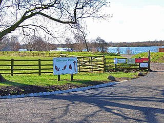
Ellerton-on-Swale or Ellerton is a small village and civil parish about a mile east of Catterick in the Richmondshire district of North Yorkshire, England. In 2015, North Yorkshire County Council estimated the population of the parish at 110.

<span class="mw-page-title-main">Eppleby</span> Village and civil parish in North Yorkshire, England

Eppleby is a village and civil parish in the Richmondshire district of North Yorkshire, England. It is located about 7 miles (11 km) north of Richmond. According to the 2011 United Kingdom census, the population of the parish was 269.

<span class="mw-page-title-main">Easby, Richmondshire</span> Hamlet and civil parish in North Yorkshire, England

Easby is a hamlet and civil parish in the Richmondshire district of North Yorkshire, England. It is situated near Richmond on the banks of the River Swale, approximately 12 miles (19 km) north west from the county town of Northallerton. The population taken by ONS was less than 100. Population information is included in the parish of Hudswell.

<span class="mw-page-title-main">Scotton, Richmondshire</span> Village and civil parish in North Yorkshire, England

Scotton is a village, civil parish and electoral ward in the Richmondshire district of North Yorkshire, England. The civil parish includes the centre and south of Catterick Garrison. The village lies in the south of the civil parish, and is effectively a suburb of Catterick Garrison. The village of Scotton is located 3+14 miles south west of Catterick village.

<span class="mw-page-title-main">Tunstall, North Yorkshire</span> Village and civil parish in North Yorkshire, England

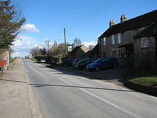
Tunstall is a village and civil parish in the Richmondshire district of North Yorkshire, England about 2 miles (3.2 km) west of Catterick Village and the A1(M) motorway. It had a population of 253 increasing to 271 at the 2011 census.

<span class="mw-page-title-main">Hudswell, North Yorkshire</span> Village and civil parish in North Yorkshire, England

Hudswell is a village and civil parish on the border of the Yorkshire Dales, in North Yorkshire, England. The population at the ONS Census 2011 was 353.

Hackforth is a small village and civil parish in the Hambleton district of North Yorkshire, England, about 4 miles (6 km) north of Bedale. Nearby settlements include Langthorne and Crakehall.

<span class="mw-page-title-main">Morland, Cumbria</span> Village and civil parish in Cumbria, England

Morland is a village and civil parish in the rolling hills of the Eden Valley in the Eden District of Cumbria, England. It lies within the historic county of Westmorland. The parish includes the hamlets of Town Head and Morland Moor, and had a population of 380 in 2001, reducing marginally to 374 at the 2011 Census.

<span class="mw-page-title-main">Church of St Anne, Catterick</span> Church in North Yorkshire, England

The Church of St Anne is a parish church in the village of Catterick, North Yorkshire, England. The present church structure dates back to the early 15th century, but some of its stones are from an earlier structure located on the same site. A place of worship in Catterick village is believed to have been in existence since the 7th century. The church has been dedicated to Saint Anne since its original consecration date of 1415.

References

  1. UK Census (2011). "Local Area Report – Hipswell Parish (1170217155)". Nomis. Office for National Statistics . Retrieved 5 October 2018.
  2. "Hipswell Parish Council > Home". Hipswell Parish Council. Retrieved 29 December 2020.
  3. "Hipswell | Domesday Book". opendomesday.org. Retrieved 25 July 2020.
  4. "History of Hipswell, in Richmondshire and North Riding | Map and description". www.visionofbritain.org.uk. Retrieved 25 July 2020.
  5. Historic England. "Hipswell Hall (1179639)". National Heritage List for England . Retrieved 29 December 2020.
  6. UK Census (2011). "Local Area Report – Hipswell Ward (as of 2011) (1237325134)". Nomis. Office for National Statistics . Retrieved 5 October 2018.
  7. "Home". Hipswell Church Of England Primary School. Retrieved 25 July 2020.
  8. "Hipswell Village Hall | History". www.spanglefish.com. Retrieved 25 July 2020.
  9. "Hello and Welcome". The Churches of Hipswell Parish. Retrieved 7 June 2010.
  10. CWGC Cemetery Report, Hipswell Churchyard.
  11. CWGC Cemetery Report, Catterick Garrison Cemetery.

Commons-logo.svg Media related to Hipswell at Wikimedia Commons