Related Research Articles

Zoning is a method of urban planning in which a municipality or other tier of government divides land into areas called zones, each of which has a set of regulations for new development that differs from other zones. Zones may be defined for a single use, they may combine several compatible activities by use, or in the case of form-based zoning, the differing regulations may govern the density, size and shape of allowed buildings whatever their use. The planning rules for each zone, determine whether planning permission for a given development may be granted. Zoning may specify a variety of outright and conditional uses of land. It may indicate the size and dimensions of lots that land may be subdivided into, or the form and scale of buildings. These guidelines are set in order to guide urban growth and development.
A variance is a deviation from the set of rules a municipality applies to land use and land development, typically a zoning ordinance, building code or municipal code. The manner in which variances are employed can differ greatly depending on the municipality. A variance may also be known as a standards variance, referring to the development standards contained in code. A variance is often granted by a Board or Committee of adjustment.
A by-law is a rule or law established by an organization or community to regulate itself, as allowed or provided for by some higher authority. The higher authority, generally a legislature or some other government body, establishes the degree of control that the by-laws may exercise. By-laws may be established by entities such as a business corporation, a neighborhood association, or depending on the jurisdiction, a municipality.

In the United States, a plat (plan) is a cadastral map, drawn to scale, showing the divisions of a piece of land. United States General Land Office surveyors drafted township plats of Public Lands Surveys to show the distance and bearing between section corners, sometimes including topographic or vegetation information. City, town or village plats show subdivisions broken into blocks with streets and alleys. Further refinement often splits blocks into individual lots, usually for the purpose of selling the described lots; this has become known as subdivision.
City of Cleburne v. Cleburne Living Center, Inc., 473 U.S. 432 (1985), was a U.S. Supreme Court case involving discrimination against the intellectually disabled.
Local government in the United States refers to governmental jurisdictions below the level of the state. Most states and territories have at least two tiers of local government: counties and municipalities. Louisiana uses the term parish and Alaska uses the term borough for what the U.S. Census Bureau terms county equivalents in those states. Civil townships or towns are used as subdivisions of a county in 20 states, mostly in the Northeast and Midwest.

The Religious Land Use and Institutionalized Persons Act (RLUIPA), Pub.L. 106–274 (text)(PDF), codified as 42 U.S.C. § 2000cc et seq., is a United States federal law that prohibits the imposition of burdens on the ability of prisoners to worship as they please and gives churches and other religious institutions a way to avoid zoning law restrictions on their property use. It also defines the term "religious exercise" to include "any exercise of religion, whether or not compelled by, or central to, a system of religious belief." RLUIPA was enacted by the United States Congress in 2000 to correct the problems of the Religious Freedom Restoration Act (RFRA) of 1993. The act was passed in both the House of Representatives and the Senate by unanimous consent in voice votes, meaning that no objection was raised to its passage, so no written vote was taken. The S. 2869 legislation was enacted into law by the 42nd President of the United States Bill Clinton on September 22, 2000.
The government of Texas operates under the Constitution of Texas and consists of a unitary democratic state government operating under a presidential system that uses the Dillon Rule, as well as governments at the county and municipal levels.
The administrative divisions of Virginia are the areas into which the Commonwealth of Virginia, a U.S. state, is divided for political and administrative purposes. Some are local governments; others are not. However, all local governments are political subdivisions of the state.
Nonconforming use in urban planning is a type of zoning variance where a parcel of land may be given an exception from current zoning ordinances due to improvements made by a prior owner or before the current zoning ordinances made the desired use non-conforming under local law. Secondary suites are commonly permitted as a non-conforming use in the zoning district they are located in because the suite was developed prior to the zoning ordinance coming into effect.
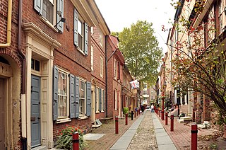
Historic districts in the United States are designated historic districts recognizing a group of buildings, properties, or sites by one of several entities on different levels as historically or architecturally significant. Buildings, structures, objects and sites within a historic district are normally divided into two categories, contributing and non-contributing. Districts greatly vary in size: some have hundreds of structures, while others have just a few.
A special use permit authorizes land uses that are allowed and encouraged by the ordinance and declared harmonious with the applicable zoning district.

In the law regulating historic districts in the United States, a contributing property or contributing resource is any building, object, or structure which adds to the historical integrity or architectural qualities that make the historic district significant. Government agencies, at the state, national, and local level in the United States, have differing definitions of what constitutes a contributing property but there are common characteristics. Local laws often regulate the changes that can be made to contributing structures within designated historic districts. The first local ordinances dealing with the alteration of buildings within historic districts was passed in Charleston, South Carolina in 1931.
Spot zoning is the application of zoning to a specific parcel or parcels of land within a larger zoned area when the rezoning is usually at odds with a city's master plan and current zoning restrictions. Spot zoning may be ruled invalid as an "arbitrary, capricious and unreasonable treatment" of a limited parcel of land by a local zoning ordinance. While zoning regulates the land use in whole districts, spot zoning makes unjustified exceptions for a parcel or parcels within a district.

Zoning in the United States includes various land use laws falling under the police power rights of state governments and local governments to exercise authority over privately owned real property. Zoning laws in major cities originated with the Los Angeles zoning ordinances of 1904 and the New York City Zoning resolution of 1916. Early zoning regulations were motivated by racism and classism. Zoning ordinances did not allow African-Americans moving into or using residences that were occupied by majority whites due to the fact that their presence would decrease the value of home. The constitutionality of zoning ordinances was upheld by the Supreme Court of the United States in Village of Euclid, Ohio v. Ambler Realty Co. in 1926
A planning and zoning commission is a local elected or appointed government board charged with recommending to the local town or city council the boundaries of the various original zoning districts and appropriate regulations to be enforced therein and any proposed amendments thereto. In addition, the Planning and Zoning Commission collects data and keeps itself informed as to the best practices generally in effect in the matter city planning and zoning. It may be qualified to act on measures affecting the present and future movement of traffic, the segregation of residential and business districts and the convenience and safety of persons and property in any way dependent on city planning and zoning.
Exclusionary zoning is the use of zoning ordinances to exclude certain types of land uses from a given community, especially to regulate racial and economic diversity. In the United States, exclusionary zoning ordinances are standard in almost all communities. Exclusionary zoning was introduced in the early 1900s, typically to prevent racial and ethnic minorities from moving into middle- and upper-class neighborhoods. Municipalities use zoning to limit the supply of available housing units, such as by prohibiting multi-family residential dwellings or setting minimum lot size requirements. These ordinances raise costs, making it less likely that lower-income groups will move in. Development fees for variance, a building permit, a certificate of occupancy, a filing (legal) cost, special permits and planned-unit development applications for new housing also raise prices to levels inaccessible for lower income people.

Local governments are established by the government of Florida and are given varying amounts of non-exclusive authority over their jurisdictions. The law governing the creation of these governments is contained both within the Florida Constitution and Florida Statutes. Local governments are incorporated in Florida by special acts of the Florida Legislature. There are four types of local governments in Florida: counties, municipalities, school districts, and special districts.
The law of Washington consists of several levels, including constitutional, statutory, regulatory and case law, as well as local ordinances. The Revised Code of Washington forms the general statutory law.
Special districts in Illinois are forms of local government that are responsible for a narrow set of responsibilities, as opposed to counties, townships, and municipal governments which have a wide range of responsibilities. School districts and community college boards are not usually considered special-purpose governments despite their narrow focus on education.
References
- ↑ A-S-P Associates v. City of Raleigh, 298 N.C. 207, 258 S.E.2d 444(1979); see also Maher v. City of New Orleans, 516 F.2d 1051 (5th Cir. 1975) and Penn Central Transp. Co. v. New York City, 438 U.S. 104 (1978)
- ↑ Maher v. City of New Orleans, 516 F.2d 1051 (5th Cir. 1975)
- 1 2 "Connecticut Trust For Historic Preservation | Historic Overlay Zoning". www.cttrust.org. Archived from the original on 2004-09-21.
- ↑ N.C. Gen. Stat. §160A-400.1 to 400.14
- ↑ See, e.g. Meares v. Town of Beaufort, --- N.C. App. ---, 667 S.E.2d 239 (2008)