Related Research Articles

Augmented reality (AR) is an interactive experience that combines the real world and computer-generated content. The content can span multiple sensory modalities, including visual, auditory, haptic, somatosensory and olfactory. AR can be defined as a system that incorporates three basic features: a combination of real and virtual worlds, real-time interaction, and accurate 3D registration of virtual and real objects. The overlaid sensory information can be constructive, or destructive. As such, it is one of the key technologies in the reality-virtuality continuum.

The Franklin Delano Roosevelt Memorial is a presidential memorial in Washington D.C., dedicated to the memory of Franklin Delano Roosevelt, the 32nd president of the United States, and to the era he represents. The memorial is one of two in Washington honoring Roosevelt.

Mixed reality (MR) is a term used to describe the merging of a real-world environment and a computer-generated one. Physical and virtual objects may co-exist in mixed reality environments and interact in real time.

The Garden District is a neighborhood of the city of New Orleans, Louisiana, United States. A subdistrict of the Central City/Garden District Area, its boundaries as defined by the New Orleans City Planning Commission are: St. Charles Avenue to the north, 1st Street to the east, Magazine Street to the south, and Toledano Street to the west. The National Historic Landmark district extends a little farther.

The Washington and Old Dominion Railroad Regional Park is a linear regional park in Northern Virginia. The park's primary feature is the Washington and Old Dominion Railroad Trail, an asphalt-surfaced paved rail trail that runs through densely populated urban and suburban communities as well as through rural areas. Most of the trail travels on top of the rail bed of the former Washington and Old Dominion Railroad, which closed in 1968.
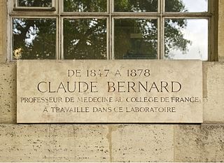
A commemorative plaque, or simply plaque, or in other places referred to as a historical marker, historic marker, or historic plaque, is a plate of metal, ceramic, stone, wood, or other material, typically attached to a wall, stone, or other vertical surface, and bearing text or an image in relief, or both, to commemorate one or more persons, an event, a former use of the place, or some other thing. Many modern plaques and markers are used to associate the location where the plaque or marker is installed with the person, event, or item commemorated as a place worthy of visit. A monumental plaque or tablet commemorating a deceased person or persons, can be a simple form of church monument. Most modern plaques affixed in this way are commemorative of something, but this is not always the case, and there are purely religious plaques, or those signifying ownership or affiliation of some sort. A plaquette is a small plaque, but in English, unlike many European languages, the term is not typically used for outdoor plaques fixed to walls.

Fort Ethan Allen was an earthwork fortification that the Union Army built in 1861 on the property of Gilbert Vanderwerken in Alexandria County, Virginia, as part of the Civil War defenses of Washington. The remains of the fort are now within Arlington County's Fort Ethan Allen Park.

Jefferson Pier, Jefferson Stone, or the Jefferson Pier Stone, in Washington, D.C., marks the second prime meridian of the United States even though it was never officially recognized, either by presidential proclamation or by a resolution or act of Congress.

Silvio A. Bedini was an American historian, specialising in early scientific instruments. He was Historian Emeritus of the Smithsonian Institution, where he served on the professional staff for twenty-five years, retiring in 1987.
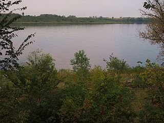
French River is an unincorporated community in Duluth Township, Saint Louis County, Minnesota, United States; located on the North Shore of Lake Superior.

Hadley Mountain is a mountain located in the southern Adirondacks in the U.S. state of New York and is the second-highest peak in Saratoga County after neighboring Tenant Mountain. The Hadley Mountain Fire Observation Station was listed on the National Register of Historic Places on September 23, 2001 for its role as a Fire lookout tower with the New York State Forest Preserve. Hadley Mountain is the highest of the three peaks that form the West Mountain ridge.

Harwood is a crossroads in Anne Arundel County, Maryland, United States, south of Annapolis on Maryland Route 2.
Chronicling America is an open access, open source newspaper database and companion website. It is produced by the United States National Digital Newspaper Program (NDNP), a partnership between the Library of Congress and the National Endowment for the Humanities. The NDNP was founded in 2005. The Chronicling America website was publicly launched in March 2007. It is hosted by the Library of Congress. Much of the content hosted on Chronicling America is in the public domain.
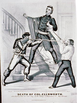
James William Jackson was an ardent secessionist and the proprietor of the Marshall House, an inn located in the city of Alexandria, Virginia, at the beginning of the American Civil War. He is known for flying a large Confederate flag – the "Stars and Bars" variant – atop his inn that was visible to President Abraham Lincoln from Washington, D.C., and for killing Col. Elmer Ellsworth in an incident that marked the first conspicuous casualty and the first killing of a Union officer in the Civil War. Jackson was killed immediately after he killed Ellsworth. While losing their lives, both gained fame as martyrs to their respective causes.
Augmented learning is an on-demand learning technique where the environment adapts to the learner. By providing remediation on-demand, learners can gain greater understanding of a topic while stimulating discovery and learning. Technologies incorporating rich media and interaction have demonstrated the educational potential that scholars, teachers and students are embracing. Instead of focusing on memorization, the learner experiences an adaptive learning experience based upon the current context. The augmented content can be dynamically tailored to the learner's natural environment by displaying text, images, video or even playing audio. This additional information is commonly shown in a pop-up window for computer-based environments.

The Elkhorn City Railroad Museum is a railroad museum located in Elkhorn City, Kentucky. The museum was established in 1990 and is dedicated to educating the public on the history of railroads in Kentucky's Eastern Mountain Coal Fields region. It also documents the history of the local timber and coal industries and local genealogy.

The Andrew Jackson Downing Urn, also known as the Downing Urn, is a memorial and public artwork located in the Enid A. Haupt Garden of the Smithsonian Institution on the National Mall in Washington, D.C.
Fort Renville, originally called Fort Adam, was a fur-trading post established by Joseph Renville and built in 1826. The fort was used as a trading post for the Columbia Fur Company, which was later purchased by the American Fur Company. The American Fur Company continued to use the post until 1846, when it moved to another site. There are no visible remains at its site, a half mile from the Lac qui Parle Mission, in Lac qui Parle State Park near Watson, Minnesota, United States. It was a significant post during the fur-trading years, but fell out of use after Renville's death in 1846. The site has been damaged by flooding and is now held in preservation by the Minnesota Historical Society. It is not open to the public. There is an overlook of the site with a sign detailing a brief history of the fur-trading post for visitors.

Blockhouse on Signal Mountain is within the Fort Sill Military Reservation, north of Lawton, Oklahoma. The rock architecture is located along Mackenzie Hill Road within the Fort Sill West Range being the Oklahoma administrative division of Comanche County.
References
- ↑ Ural, Susannah J. (April 2011). "Ural on URLs: The Historical Marker Database". Civil War Times . 50 (2): 71. ISSN 0009-8094 . Retrieved October 10, 2019.
- 1 2 Stephens, Steve (July 17, 2015). "Website locates wide range of historical markers". The Columbus Dispatch . Retrieved October 10, 2019.
- ↑ Baram, Uzi (September 27, 2019). "In an Age of Heritage Signs, Encouraging Archaeological Sites to be Cosmopolitan Canopies". Present Pasts. 9 (1): 1–8. doi: 10.5334/pp.79 .
- 1 2 Judge, Elizabeth F.; Brown, Tenille E. (2017). "Pokémorials: Placing Norms in Augmented Reality". U.B.C. Law Review. 50 (4): 971–1016.
- ↑ "About the Historical Marker Database". Historical Marker Database. Retrieved October 11, 2019.
- ↑ Sullivan, Laura; Jin, Connie Hanzhang; McMillan, Nick (April 21, 2024). "Curious, fascinating and offensive markers from around the U.S." NPR News.
- 1 2 Douberley, Amanda; Druecke, Paul (2016). "The Memory Frame: Set in Stone, a Dialogue". In Knight, Cher Krause; Senie, Harriet F. (eds.). A Companion to Public Art. John Wiley & Sons, Inc. pp. 376–385. doi:10.1002/9781118475331.ch17. ISBN 9781118475331.
- ↑ Laccetti, Silvio (July 2, 2011). "Opinion: Historical Marker Database website provides fun way to record N.J. landmarks". The Times (Trenton). Retrieved October 10, 2019.
- ↑ Díaz-Kommonen, L.; Timonen, A.; Reunanen, M. (2007). "ImaNote: a Zoomable Web-Based Multi-User Image Viewing and Annotation Tool". Eurographics. S2CID 17073263.