Holbeck

Last updated

Holbeck
Holbeck Moor Road, Holbeck - geograph.org.uk - 529637.jpg
Holbeck Moor road
Leeds UK location map.svg
Red pog.svg
Holbeck
West Yorkshire UK location map.svg
Red pog.svg
Holbeck
Location within West Yorkshire
Population5,505 
OS grid reference SE311314
Metropolitan borough
Metropolitan county
Region
Country England
Sovereign state United Kingdom
Post town LEEDS
Postcode district LS11
Dialling code 0113
Police West Yorkshire
Fire West Yorkshire
Ambulance Yorkshire
UK Parliament
List of places
UK
England
Yorkshire
53°47′20″N1°33′18″W / 53.789°N 1.555°W / 53.789; -1.555

Holbeck is an inner city area of Leeds, West Yorkshire, England. It begins on the southern edge of Leeds city centre and mainly lies in the LS11 postcode district. The M1 and M621 motorways used to end/begin in Holbeck. Now the M621 is the only motorway that passes through the area since the end of the M1 moved to Hook Moor near Aberford. Since large parts of Holbeck have been vacated in preparation for the regeneration of the area, the district has in large parts suffered from a population exodus. Holbeck had a population of 5,505 in 2011. [1] [2] The district currently falls within the Beeston and Holbeck ward of Leeds City Council.

Contents

The Leeds and Liverpool Canal also runs through Holbeck.

History

Detail of J. M. W. Turner's 1816 painting Leeds, showing Holbeck. Viewed looking northwards from Beeston Hill, the white tower belongs to St Paul's Church (demolished 1905) on the far side of the River Aire. Below the tower stands Marshall's Mill in Holbeck, and to its right, the chimney emitting black smoke, is Fenton and Murray's foundry. Below the foundry, with a black chimney, stands Holbeck Moor Mill. The two-storey building below and to the right of the mill is Holbeck Workhouse. JMWTurner Leeds detail of Holbeck.png
Detail of J. M. W. Turner's 1816 painting Leeds, showing Holbeck. Viewed looking northwards from Beeston Hill, the white tower belongs to St Paul's Church (demolished 1905) on the far side of the River Aire. Below the tower stands Marshall's Mill in Holbeck, and to its right, the chimney emitting black smoke, is Fenton and Murray's foundry. Below the foundry, with a black chimney, stands Holbeck Moor Mill. The two-storey building below and to the right of the mill is Holbeck Workhouse.
Temple Works Temple Works.jpg
Temple Works
Marshall's Mill Marshalls-mill-small.jpg
Marshall's Mill
Holbeck Viaduct Holbeckviaduct.jpg
Holbeck Viaduct

Early history

The Hol Beck is the name of a stream running from the south-west into the River Aire. [4] It was the deposition of silt by the Hol Beck and nearby the Sheepscar Beck from the north that led to a fording place and a small community which eventually grew into the town of Leeds. [5]

The place-name Holbeck is first attested in the 12th century in forms such as Holebec and Holesbec, from hol 'a hollow' and beck 'a stream' (an Old Norse loanword, from bekkr, reflecting Scandinavian influence in Yorkshire during the Viking Age), thus 'stream in the hollow'. [6] The old manor belonged to the priory of the Holy Trinity at York and after the Dissolution of the Monasteries passed to the Darcy and Ingram families. [7]

In the 18th century Holbeck was still a village outside Leeds, and expanded with the development of hand weaving. [8] At this time, Holbeck was known for its spa water, which resembled that of Harrogate, and was carried into Leeds for sale. The supply diminished when numerous wells were sunk to supply the mills and works in the area and the water, which previously rose to the surface, could only be obtained by pumping from a considerable depth. [7]

19th century

In the first half of the 19th century, Holbeck village was a hamlet of few streets. Most were owned by John Scholey (1774–1834) and are listed in his will at the Borthwick Institute for Archives, University of York. His family sold the properties at the beginning of the Industrial Revolution. It 'was still listed as a separate out-township as late as 1878, and was routinely cited without reference to Leeds'. [8]

But as the area industrialised around the mid-19th century, it became increasingly integrated into Leeds. [8] There were ironworks, works for the manufacture of steam engines and machinery of all kinds. [7] Key factories were:

In the mid-19th century Holbeck was one of the most densely populated suburbs of Leeds, described in 1834 as 'one of the most crowded, one of the most filthy, one of the most unpleasant, and one of the most unhealthy villages in the county of York'. [8] Slum clearance took place after the cholera epidemics of 1832 and 1849. [10] [11] Holbeck railway station (now demolished) was built during the century. It was notable because it was a two-tier station with a low line and a high line; the railway viaduct, built in 1869, was thought to be one of the engineering marvels of the Victorian age. In 1877, the Holbeck Working Men's Club opened, one of the first in the country. [12]

20th century

Holbeck has suffered significant decline since the 19th century; in 1921, its population was around 38,152, but in 2010 was 4,470. [13] Further slum clearance took place in the 1930s, and a workhouse, built by around 1870, was at this time converted into a hostel for the destitute, before being demolished in the 1970s and replaced with a school. [14] Many of the industrial buildings and warehouses have been demolished or fallen into disrepair. Holbeck is nevertheless home to 33 listed buildings and many other important architectural structures. Some of the most notable of these are: The Dark Arches, the Hol Beck, Marshall's Mill, the Midland Mills, the Round Foundry, Temple Works, Tower Works and two railway roundhouses. [9] The last active church in the area (until the recent establishment of new ones) was St. Matthew's, built in 1829–30 and deconsecrated in 1981. [15]

The railway station has been demolished, but plans began to be developed in 2014 to convert the track bed (which is currently overgrown with trees and shrubs) into a raised walkway leading directly into Leeds city centre. [16] In the 1960s, Leeds sought to become a 'motorway city', and 1972–75 saw the completion of the M621, which runs through Holbeck, and the A643, creating a new boundary on Holbeck's west side. [17]

From 1956 to 2004 Kays Catalogues was the largest employer in Holbeck, acquiring Samuel Driver Ltd in 1956 and taking over Temple Works on Marshall Street, expanding the site in the 1950s and again in 1981. [18] Part of the Kay's premises is a listed building. [19]

Recent times

In 2003 Kays was bought by the Barclay Brothers, and within a year the Holbeck distribution centre had been closed down. The 1981 distribution centre was soon demolished, the 1952 building became derelict, and in December 2008 Temple Works suffered a structural failure. [20]

Geography

The name Holbeck derives its name from the brook on which it is situated. Since industrialisation the beck, a natural watercourse, has been canalised with stone-set floor and stone walls. It is crossed by several bridges giving access from Water Lane. Holbeck is on the flood plain on the south side of the River Aire of which the Hol Beck is a tributary. [9]

It covers an area of about 553 acres. [7] According to Simon Bradley, writing in 2016,

The boundaries of Holbeck have moved over time, but my interviewees broadly agree on where it lies: bounded by Leeds City railway station and the River Aire to the North; the M621 to the south; the east perimeter follows Victoria Road, overlooked by Bridgewater Place (known locally as 'The Dalek'); the west is defined by the A643 feeder road joining the M621 to Armley Gyratory. For the interviewees, the north and south boundaries are more debatable than the east and west. [21]

Confusingly, for example, Holbeck Cemetery, founded in the mid-1850s, is to the south of Holbeck, in Beeston. [22]

Regeneration

The clearance of Runswick Place in preparation for demolition Runswick Place clearing.jpg
The clearance of Runswick Place in preparation for demolition

Over recent years efforts have been made to regenerate the Holbeck area. The most notable scheme is the Holbeck Urban Village, which is expected to attract investment of around £800 million and create around 5,000 jobs. However, the area surrounding the 'Village' is deprived and run down. From 2007, Leeds City Council began vacating the back-to-back housing and in 2010 began demolition.

The main area of demolition during the regeneration was the Jenkinson Estate. Many low-rise flat blocks were demolished and the remaining housing received new UPVC windows, new roofing & external covering. The land where the low-rise flat blocks were has been used for brand-new social housing including four-bedroom family homes to two-bedroom apartments.

Three rows of back-to-back terraced homes on Brown Lane-West and Top Moor Side have been demolished and made way for some more social housing, built by Keepmoat. In July 2017, residents had noticed some of the council-owned back-to-back terraced homes are being renovated with new windows and roofing.

Landmarks

The Old Library, Holbeck. The Old Library, Holbeck. - geograph.org.uk - 112621.jpg
The Old Library, Holbeck.

Holbeck Conservation Area includes several industrial archaeological sites and Listed buildings. Holbeck is unique in Leeds as an area where many early to mid 19th century industrial buildings survive in an unaltered group within the original street pattern. The buildings are utilitarian two or three-storey brick structures with some larger complexes such as Temple Mill and the brick terracotta towers of Tower Works. Railway viaducts cut through the area, notably that of the Leeds and Bradford Railway of 1846 and the London and North Western Railway's extension line of 1882. [9] Holbeck Public Library is built in red brick and terracotta. [23]

The 1877 Holbeck Working Men's Club is the oldest surviving working men's club in the UK. [12]

Religion

The old chapel, dedicated to St. Catherine and recorded in ancient documents as existing in 809, was rebuilt on the same site in the early 18th century. It became inadequate for the rapidly increasing population at that time and was demolished in 1836. The church of St. Matthew was built on common land next to the old burial-ground. It cost £3,786 and was a Commissioners' church built by the Parliamentary Commissioners and consecrated in 1832. It is built in the early English style. There were places of worship for Independents, Wesleyans and other denominations. [7] Currently the groups that meet in Holbeck include the Holbeck Christian Fellowship and Mosaic Church, which is located on Sweet Street in a warehouse opposite the Commercial pub and has been in Holbeck since early 2008.

Amenities

The area has lost amenities as part of the population exodus connected with the demolition of properties as part of the regeneration scheme. Kwik Save supermarket closed in 2005, leaving small independent convenience stores. The post office closed in 2008, but reopened in 2009. There is a bookmaker and several fast food takeaways.

Managed approach to on-street prostitution

In 2014 Leeds Council in conjunction with West Yorkshire Police trialled a managed approach to prostitution which allowed for soliciting and purchasing of sex in a light industrial area in a bid to:

After a review in 2016 it was announced that this was to continue indefinitely. [25] However, the managed zone policy was ended in March 2020 following a local public campaign. [26] The activities there were featured in the 2016–17 BBC documentary series Sex, Drugs & Murder: Life in the Red Light Zone .

Notable residents

See also

Documentaries and histories

Related Research Articles

<span class="mw-page-title-main">West Yorkshire</span> County of England

West Yorkshire is a metropolitan and ceremonial county in the Yorkshire and the Humber region of England. It borders North Yorkshire to the north and east, South Yorkshire and Derbyshire to the south, Greater Manchester to the south-west, and Lancashire to the west. The city of Leeds is the largest settlement.

<span class="mw-page-title-main">Morley, West Yorkshire</span> Market town and civil parish in West Yorkshire, England

Morley is a market town and a civil parish within the City of Leeds metropolitan borough, in West Yorkshire, England. Morley is the largest town in the borough after Leeds itself. Morley forms part of the Heavy Woollen District.

<span class="mw-page-title-main">Armley</span> Human settlement in England

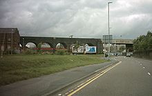
Armley is a district in the west of Leeds, West Yorkshire, England. It starts less than 1 mile (1.6 km) from Leeds city centre. Like much of Leeds, Armley grew in the Industrial Revolution and had several mills, one of which now houses the Leeds Industrial Museum at Armley Mills. Armley is predominantly and historically a largely working class area of the city, still retains many smaller industrial businesses, and has many rows of back-to-back terraced houses.

<span class="mw-page-title-main">BBC Radio Leeds</span> Radio station in Leeds

BBC Radio Leeds is the BBC's local radio station serving the county of West Yorkshire.

<span class="mw-page-title-main">Beeston, Leeds</span> Suburb of Leeds, West Yorkshire, England

Beeston is a suburb of Leeds, West Yorkshire, England located on a hill about 2 miles (3 km) south of the city centre.

<span class="mw-page-title-main">Middleton, Leeds</span> Suburb of Leeds, West Yorkshire, England

Middleton is a largely residential suburb of Leeds in West Yorkshire, England and historically a village in the West Riding of Yorkshire. It is situated on a hill 4 miles (6 km) south of Leeds city centre and 165 miles (266 km) north north-west of London.

<span class="mw-page-title-main">Belle Isle, Leeds</span> Large suburb 3 mi south of Leeds city centre, West Yorkshire, England

Belle Isle is a large suburb 3 miles (5 km) south of Leeds city centre, West Yorkshire, England. It is bounded to the north and east by the M621 motorway.

<span class="mw-page-title-main">Deighton, Huddersfield</span> Human settlement in England

Deighton pronounced as Dee-ton is a district of Huddersfield, West Yorkshire, England. It is situated 2 miles (3.2 km) north east of the town centre and lies off the A62 Leeds Road.

<span class="mw-page-title-main">Cottingley, Leeds</span> Urban area in Leeds, West Yorkshire, England

Cottingley is an urban area in the south-west of Leeds, West Yorkshire, England.

<span class="mw-page-title-main">Temple Works</span> Former flax mill and listed building in Holbeck, West Yorkshire, England

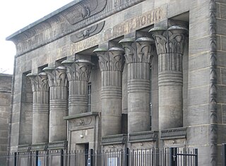
Temple Works is a former flax mill in Holbeck, Leeds, West Yorkshire, England. It was designed by the engineer James Coombe a former pupil of John Rennie; the painter David Roberts; and the architect Joseph Bonomi the Younger. It was built in the Egyptian Revival style for the industrialist John Marshall between 1836 and 1840 to contain a 240 horsepower double-beam engine by Benjamin Hick. Temple Works is the only Grade I listed building in Holbeck.

<span class="mw-page-title-main">Marshall's Mill</span>

Marshall's Mill is a former flax spinning mill on Marshall Street in Holbeck, Leeds, West Yorkshire, England.

<span class="mw-page-title-main">River Skirfare</span> River in North Yorkshire, England

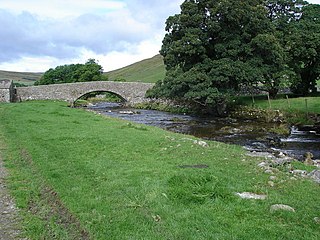
River Skirfare is a small river in North Yorkshire, England, that flows through Littondale and ends where it joins the larger River Wharfe. The source is the confluence of Foxup Beck and Cosh Beck at the hamlet of Foxup.

<span class="mw-page-title-main">Transport in Leeds</span> Road, rail and bus transportation in Leeds, England

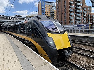
Transport in Leeds consists of extensive road, bus and rail networks in Leeds, West Yorkshire, England. Public transport in the Leeds area is coordinated and developed by West Yorkshire Metro. The city has good rail and road links to the rest of the country. Leeds railway station is one of the busiest in Britain, and Leeds is connected to the national road network via the A1(M) motorway, M1 motorway and M62 motorway. The city is served by Leeds Bradford Airport.

<span class="mw-page-title-main">Leeds Minster</span> Church in Leeds, West Yorkshire, England

Leeds Minster, or the Minster and Parish Church of Saint Peter-at-Leeds is the minster church of Leeds, West Yorkshire, England. It stands on the site of the oldest church in the city and is of architectural and liturgical significance. A church is recorded on the site as early as the 7th century, although the present structure is a Gothic Revival one, designed by Robert Dennis Chantrell and completed in 1841. It is dedicated to Saint Peter and was the Parish Church of Leeds before receiving the honorific title of "Minster" in 2012. It has been designated a Grade I listed building by Historic England.

<span class="mw-page-title-main">Scouting in Yorkshire and the Humber</span> Youth activities in an English region

Scouting in Yorkshire and the Humber is largely represented by the Scout Association of the United Kingdom and some Groups of traditional Scouting including the Baden-Powell Scouts' Association.

<span class="mw-page-title-main">Architecture of Leeds</span> Buildings of Leeds, West Yorkshire, England

The architecture of Leeds, a city and metropolitan borough in West Yorkshire, England, encompasses a wide range of architectural styles and notable buildings. As with most northern industrial centres, much of Leeds' prominent architecture is of the Victorian era. However, the City of Leeds also contains buildings from as early as the Middle Ages such as Kirkstall Abbey, one of Britain's best preserved ruined Cistercian monasteries, as well as examples of 20th century industrial architecture, particularly in the districts of Hunslet and Holbeck.

<span class="mw-page-title-main">Leeds Civic Trust</span> Voluntary organisation and registered charity

Leeds Civic Trust is a voluntary organisation and registered charity established in Leeds, West Yorkshire, England in 1965. Affiliated to the national charity Civic Voice, its stated purpose is "to stimulate public interest in and care for the beauty, history, and character of the city and locality, to encourage high standards of design, architecture and town planning; [and] to encourage the development and improvement of features of general public amenity".

<span class="mw-page-title-main">Leeds Blitz</span>

The Leeds Blitz comprised nine air raids on the city of Leeds by the Nazi German Luftwaffe. The heaviest raid took place on the night of 14/15 March 1941, affecting the city centre, Beeston, Bramley and Armley. The city was subjected to other raids during the Second World War, but they were relatively minor; only the March 1941 raid caused widespread damage, including to the city's museum and its artefacts.

<span class="mw-page-title-main">Charles Jenkinson (priest)</span>

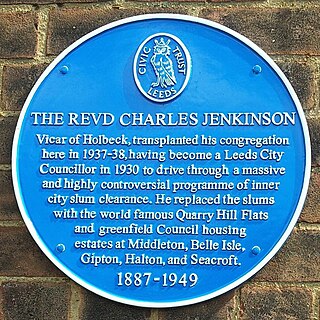
Charles Jenkinson was a Church of England clergyman, housing reformer, and Leeds councillor.

<span class="mw-page-title-main">Alaric Hall</span> British philologist

Alaric Hall is a British philologist who is an associate professor of English and director of the Institute for Medieval Studies at the University of Leeds. He has, since 2009, been the editor of the academic journal Leeds Studies in English and its successor Leeds Medieval Studies.

References

  1. Holbeck is made up of 21 Output areas in the Beeston and Holbeck ward http://ukcensusdata.com/beeston-and-holbeck-e05001415#sthash.izecXSHH.dpbs
  2. Holbeck is also made up of 2 output areas in the City and Hunslet ward in the centre of Leeds http://ukcensusdata.com/city-and-hunslet-e05001420#sthash.uqs192IK.dpbs
  3. Matthew Imms, ‘Leeds from Beeston Hill 1816 by Joseph Mallord William Turner’, catalogue entry, July 2014, in David Blayney Brown (ed.), J.M.W. Turner: Sketchbooks, Drawings and Watercolours, Tate Research Publication (September 2014), accessed 29 April 2019.
  4. Leodis Hol Beck
  5. W. R. Mitchell (2000), A History of Leeds Phillimore, West Sussex, ISBN   1 86077 130 0
  6. A. H. Smith, The Place-Names of the West Riding of Yorkshire, English Place-Names Society, 30–37, 8 vols (Cambridge: Cambridge University Press, 1961–63), III 216.
  7. 1 2 3 4 5 Lewis, Samuel (1848). "Holbeck". A Topographical Dictionary of England. British History Online. pp. 524–527. Retrieved 24 September 2010.
  8. 1 2 3 4 Bradley, Simon (2016). Archaeology of the Voice: Exploring Oral History, Locative Media, Audio Walks, and Sound Art as Sitespecific Displacement Activities (PDF). University of Huddersfield: Unpublished PhD thesis. p. 31.
  9. 1 2 3 4 "Holbeck Conservation Area Appraisal" (PDF). Leeds Council. Retrieved 5 April 2017.
  10. Bradley, Simon (2016). Archaeology of the Voice: Exploring Oral History, Locative Media, Audio Walks, and Sound Art as Sitespecific Displacement Activities (PDF). University of Huddersfield: Unpublished PhD thesis. pp. 49, fn. 20.
  11. Leach & Pevsner 2009 , p. 553
  12. 1 2 John Baron, 'Regulars rally to save UK's oldest working men's club', The Guardian (31 May 2013).
  13. Bradley, Simon (2016). Archaeology of the Voice: Exploring Oral History, Locative Media, Audio Walks, and Sound Art as Sitespecific Displacement Activities (PDF). University of Huddersfield: Unpublished PhD thesis. p. 32.
  14. Bradley, Simon (2016). Archaeology of the Voice: Exploring Oral History, Locative Media, Audio Walks, and Sound Art as Sitespecific Displacement Activities (PDF). University of Huddersfield: Unpublished PhD thesis. pp. 49, 74.
  15. Bradley, Simon (2016). Archaeology of the Voice: Exploring Oral History, Locative Media, Audio Walks, and Sound Art as Sitespecific Displacement Activities (PDF). University of Huddersfield: Unpublished PhD thesis. pp. 33, fn. 10.
  16. Brown, Jonathan. "Leeds skywalk pipedream is on way to being revived". Yorkshire Evening Post. Retrieved 10 February 2014.
  17. Bradley, Simon (2016). Archaeology of the Voice: Exploring Oral History, Locative Media, Audio Walks, and Sound Art as Sitespecific Displacement Activities (PDF). University of Huddersfield: Unpublished PhD thesis. p. 48.
  18. Bradley, Simon (2016). Archaeology of the Voice: Exploring Oral History, Locative Media, Audio Walks, and Sound Art as Sitespecific Displacement Activities (PDF). University of Huddersfield: Unpublished PhD thesis. p. 51.
  19. Kays Heritage Group Archived 22 March 2015 at the Wayback Machine
  20. Bradley, Simon (2016). Archaeology of the Voice: Exploring Oral History, Locative Media, Audio Walks, and Sound Art as Sitespecific Displacement Activities (PDF). University of Huddersfield: Unpublished PhD thesis. p. 51.
  21. Bradley, Simon (2016). Archaeology of the Voice: Exploring Oral History, Locative Media, Audio Walks, and Sound Art as Sitespecific Displacement Activities (PDF). University of Huddersfield: Unpublished PhD thesis. p. 47.
  22. Cf. Bradley, Simon (2016). Archaeology of the Voice: Exploring Oral History, Locative Media, Audio Walks, and Sound Art as Sitespecific Displacement Activities (PDF). University of Huddersfield: Unpublished PhD thesis. pp. 306–7.
  23. Leach & Pevsner 2009 , p. 554
  24. "Safer Leeds Managed Approach". Telegraph.co.uk. Retrieved 12 November 2016.
  25. Yorkshire Evening Post 29 July 2016 "Exclusive: ‘Legal red light zone’ here to stay in Leeds"
  26. Port, Samuel (25 October 2021). "Life on road where squirming residents see people having sex outside their homes". Mirror Online.

Commons-logo.svg Media related to Holbeck at Wikimedia Commons