
Hood River County is one of the 36 counties in the U.S. state of Oregon. As of the 2010 census, the population was 22,346. The county seat is Hood River. The county was established in 1908 and is named for the Hood River, a tributary of the Columbia River.
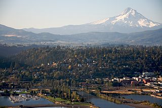
The city of Hood River is the seat of Hood River County, Oregon, United States. It is a port on the Columbia River, and is named for the nearby Hood River. As of the 2010 census, the city population was 7,167.

Beech Mountain is a town in both Avery and Watauga counties in the U.S. state of North Carolina. As of the 2010 census, the town population was 320. The town is located atop Beech Mountain and is the highest town east of the Rocky Mountains at 5,506 ft in elevation. The nearest municipality at a higher elevation is Des Moines, New Mexico, some 1,220 miles away.

The Columbia River Gorge is a canyon of the Columbia River in the Pacific Northwest of the United States. Up to 4,000 feet (1,200 m) deep, the canyon stretches for over eighty miles (130 km) as the river winds westward through the Cascade Range, forming the boundary between the state of Washington to the north and Oregon to the south. Extending roughly from the confluence of the Columbia with the Deschutes River in the east down to the eastern reaches of the Portland metropolitan area, the water gap furnishes the only navigable route through the Cascades and the only water connection between the Columbia Plateau and the Pacific Ocean. It is thus the route of Interstate 84, U.S. Route 30, Washington State Route 14, and railroad tracks on both sides.

The Hood River, formerly known as Dog River, is a tributary of the Columbia River in northwestern Oregon in the United States. Approximately 25 miles (40 km) long from its mouth to its farthest headwaters on the East Fork, the river descends from wilderness areas in the Cascade Range on Mount Hood and flows through the agricultural Hood River Valley to join the Columbia River in the Columbia River Gorge.
The North Shore is a term commonly used to refer to several areas adjacent to Vancouver, British Columbia, Canada:
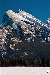
Snowkiting or kite skiing is an outdoor winter sport where people use kite power to glide on snow or ice. The skier uses a kite to give them power over large jumps. The sport is similar to water-based kiteboarding, but with the footwear used in snowboarding or skiing. The principles of using the kite are the same, but in different terrain. In the early days of snowkiting, foil kites were the most common type; nowadays many kiteboarders use inflatable kites. However, since 2013, newly developed racing foil kites seem to dominate speed races and expedition races, like Red Bull Ragnarok and the Vake mini-expedition race. Snowkiting differs from other alpine sports in that it is possible for the snowkiter to travel uphill and downhill with any wind direction. Like kiteboarding, snowkiting can be very hazardous and should be learned and practiced with care. Snowkiting is becoming increasingly popular in places often associated with skiing and snowboarding, such as Russia, Canada, Iceland, France, Switzerland, Austria, Norway, Sweden, Finland and the Northern and Central United States. The sport is becoming more diverse as adventurers use kites to travel great distances and sports enthusiasts push the boundaries of freestyle, big air, speed and back country exploration.

The Dartmouth Outing Club (DOC) is the oldest and largest collegiate outing club in the United States. Proposed in 1909 by Dartmouth College student Fred Harris to "stimulate interest in out-of-door winter sports", the club soon grew to encompass the College's year-round outdoor recreation and has had a major role in defining Dartmouth College.

Alpental, named after the German word for alpine valley, is both a valley in eastern King County, Washington, United States and a ski area in the valley. The valley is about 50 miles (80 km) east of Seattle, Washington and is north of Snoqualmie Pass, in the Washington Cascades. It is a popular outdoor recreation destination in both the summer and winter. The ski area is one of four areas which make up The Summit at Snoqualmie.

The Mount Hood National Forest is 62 miles (100 km) east of the city of Portland, Oregon, and the northern Willamette River valley. The Forest extends south from the Columbia River Gorge across more than 60 miles (97 km) of forested mountains, lakes and streams to the Olallie Scenic Area, a high lake basin under the slopes of Mount Jefferson. The Forest includes and is named after Mount Hood, a stratovolcano. The Forest encompasses some 1,067,043 acres (4,318.17 km2). Forest headquarters are located in Sandy, Oregon. A 1993 Forest Service study estimated that the extent of old growth in the Forest was 345,300 acres (139,700 ha). The Forest is divided into four separate districts - Barlow, Clackamas River (Estacada), Hood River, and Zigzag (Zigzag).

Oregon Route 35 is a state highway in the U.S. state of Oregon, running between Government Camp on the slopes of Mount Hood and the city of Hood River. OR 35 traverses part of the Mt. Hood Highway No. 26 and part of the Historic Columbia River Highway No. 100 of the Oregon state highway system. Along the Historic Columbia River Highway in Hood River, the route is silently concurrent with U.S. Route 30.

Mount Tom, 1,202 feet (366 m), is a steep, rugged traprock mountain peak on the west bank of the Connecticut River 4.5 miles (7 km) northwest of downtown Holyoke, Massachusetts. The mountain is the southernmost and highest peak of the Mount Tom Range and the highest traprock peak of the 100-mile (160 km) long Metacomet Ridge. A popular outdoor recreation resource, the mountain is known for its continuous line of cliffs and talus slopes visible from the south and west, its dramatic 1,100-foot (340 m) rise over the surrounding Connecticut River Valley, and its rare plant communities and microclimate ecosystems.

The North Shore Mountains are a mountain range overlooking Vancouver in British Columbia, Canada. Their southernmost peaks are visible from most areas in Vancouver and form a distinctive backdrop for the city.

Central Oregon is a geographic region in the U.S. state of Oregon and is traditionally considered to be made up of Deschutes, Jefferson, and Crook counties. Other definitions include larger areas, often encompassing areas to the north towards the Columbia River, eastward towards Burns, or south towards Klamath Falls. These three counties have a combined population of 200,431 as of the 2010 census, with Deschutes the largest of the three counties, having approximately four times the population of the other two counties combined. As of 2015, the most populous city in the region is Bend, with an estimated 87,014 residents. As defined by the three county definition, Central Oregon covers 7,833 square miles (20,290 km2) of land. Central Oregon has had 3 record tourism years beginning in 2012. Over 2.2 million people visited Central Oregon in 2012 and again in 2013.
Taconic State Park is located in Columbia and Dutchess County, New York abutting Massachusetts and Connecticut within the Taconic Mountains. The state park is located off New York State Route 344 south of Interstate 90 and 110 miles (180 km) north of New York City. It features camping, hiking, bicycling, hunting, cross county skiing and other recreational opportunities.
Dakine is an American outdoor clothing company specializing in sportswear and sports equipment for alternative sports based in Hood River Oregon. Founded in Hawaii, the name comes from the Hawaiian Pidgin word "da kine". Now based in Hood River, Oregon, the company also sponsors athletes from the lifestyle and sporting fields of skiing, biking, windsurfing, kiting, snowboarding, surfing, and skateboarding.

Brace Mountain is the peak of a ridge in the southern Taconic Mountains, near the tripoint of the U.S. states of New York, Connecticut and Massachusetts. Its 2,311-foot (704 m) main summit is located in New York; it is the highest point in that state's Dutchess County.

Outdoor recreation or outdoor activity refers to recreation engaged in out of doors, most commonly in natural settings. The activities that encompass outdoor recreation vary depending on the physical environmental they are being carried out in. These activities can include fishing, hunting, backpacking, and horseback riding — and can be completed individually or collectively. Outdoor recreation is a broad concept that encompasses a varying range of activities and landscapes.

Dog Mountain rises above the north side of the Columbia River Gorge in the U.S. state of Washington. The base of the mountain is in Skamania County along Washington State Route 14, about 9 miles (14 km) east of Stevenson and 53 miles (85 km) east of Vancouver. From its base at 150 feet (46 m), it climbs steeply to an elevation of 2,948 feet (899 m).
Chilliwack is a city made up of several amalgamated villages and communities. The urban core has a decidedly North-South axis bisected by the Trans-Canada Highway. The city is bounded in north by the Fraser River, in the east by the Eastern Hillsides, in the south by the Canada-U.S. border, and in the west by the Vedder Canal.
