Related Research Articles
Worcestershire is a county in the West Midlands of England. The area that is now Worcestershire was absorbed into the unified Kingdom of England in 927, at which time it was constituted as a county. Over the centuries the county borders have been modified, but it was not until 1844 that substantial changes were made. This culminated with the abolition of Worcestershire in 1974 with its northern area becoming part of the West Midlands and the rest part of the county of Hereford and Worcester. However, in 1998 the county of Hereford and Worcester was abolished and Worcestershire was reconstituted without the northern area, which was ceded to the West Midlands.

Eadburh was the daughter of King Edward the Elder of England and his third wife, Eadgifu of Kent.
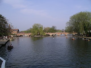
The River Avon in central England flows generally southwestwards and is a major left-bank tributary of the River Severn, of which it is the easternmost. It is also known as the Warwickshire Avon or Shakespeare's Avon, to distinguish it from several other rivers of the same name in the United Kingdom.

Malvern Hills is a local government district in Worcestershire, England. Its council is based in the town of Malvern, and its area covers most of the western half of the county, including the outlying towns of Tenbury Wells and Upton-upon-Severn. It was originally formed in 1974 and was subject to a significant boundary reform in 1998. In the 2011 census the population of the Malvern Hills district was 74,631.
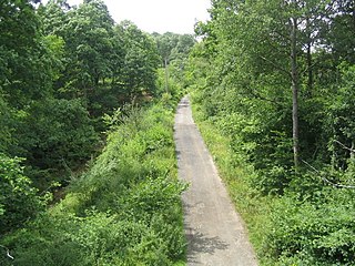
Wyre Forest is a large, semi-natural woodland and forest measuring 26.34 square kilometres (10.17 sq mi) which straddles the borders of Worcestershire and Shropshire, England.

Wychavon is a local government district in Worcestershire, England. Its council is based in the town of Pershore, and the other towns in the district are Droitwich Spa and Evesham. The district extends from the south-east corner of Worcestershire north and west. It borders all the other districts of Worcestershire, as well as the counties of Gloucestershire and Warwickshire.
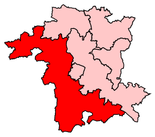
West Worcestershire is a constituency in Worcestershire represented in the House of Commons of the UK Parliament since 2010 by Harriett Baldwin, a Conservative. The constituency is considered a safe seat for the Conservatives. The constituency boundaries roughly correspond with the Malvern Hills District.

White Ladies Aston is a village in the Wychavon local government district of Worcestershire, England, United Kingdom, and also lends its name to the Civil Parish in which the village is located. The village is located to the east of the A44 which started as a Saltway linking Droitwich to Oxford. To the south is Pershore and five miles west is Worcester. The parish is bound to the east by the Bow Brook. The parish, according to the 2011 census, has 87 households with 220 residents.

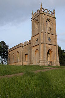
Croome Court is a mid-18th-century Neo-Palladian mansion surrounded by extensive landscaped parkland at Croome D'Abitot, near Upton-upon-Severn in south Worcestershire, England. The mansion and park were designed by Lancelot "Capability" Brown for the 6th Earl of Coventry, and they were Brown's first landscape design and first major architectural project. Some of the mansion's rooms were designed by Robert Adam. The Church of St Mary Magdalene that sits within the grounds of the park is owned and cared for by the Churches Conservation Trust.

Severn Stoke is an English village and civil parish in the Malvern Hills District, in the south of the county of Worcestershire, alongside the A38 trunk road. It had a population of 611 in 2011.
Royal Air Force Defford or more simply RAF Defford is a former Royal Air Force station located 1.1 miles (1.8 km) northwest of Defford, Worcestershire, England.

Defford is a small village in the county of Worcestershire, England, located between the towns of Pershore and Upton-upon-Severn. It was once part of the Royal forest of Horewell. The woodlands were mostly removed around the time of the Civil War.

Hill Croome is a village, and a civil parish which covers 1000 acres, in the Malvern Hills District in the county of Worcestershire, England. Historically a parish in the lower division of the hundred of Oswaldslow, according to the 2001 census the parish had a population of 169. Hill Croome was once part of the Royal forest of Horewell.

Ripple is a village and civil parish in the county of Worcestershire, England. Ripple is one of the most southerly parishes in the county and is situated on the A38 road with the River Severn as its western boundary. Together with the villages and hamlets of Ryall, Holly Green, The Grove, Naunton, and Uckinghall, the parish has a combined population of 1,799.
Croome D'Abitot is a village and civil parish, which shares a joint parish council with Severn Stoke, in the Malvern Hills District in the county of Worcestershire, England. The parish church of St Mary Magdalene is situated in the grounds of Croome Court.

Strensham is a village in the Wychavon district of Worcestershire. In the 2001 census, the civil parish of Strensham had a population of 314 across 127 households. Since 1991, the population has risen 28.7% from 244 residents.
Dormston is a village and civil parish in Worcestershire about 3 miles (4.8 km) south of Redditch.
References
- Raymond Grant (1991). The royal forests of England. Wolfeboro Falls, NH: Alan Sutton. ISBN 0-86299-781-X. OL 1878197M. 086299781X.
- "Parishes: Pershore, St Andrew with Defford and Wick", in A History of the County of Worcester: Volume 4, edited by William Page and J. W. Willis-Bund (London, 1924), pp. 163–177. Accessed 30 August 2015
- Worcestershire Natural Areas J. J. Day, Worcestershire Record, Issue 10, April 2001].