Glasgow, the largest city in Scotland, has several distinct styles of residential buildings. Building styles reflect historical trends, such as rapid population growth in the 18th and 19th centuries, deindustrialisation and growing poverty in the late 20th century, and civic rebound in the 21st century.
The city is known for its tenements,[1] where a common stairwell is informally known as a close.[2][3] These were the most popular form of housing in 19th- and 20th-century Glasgow and remain the most common form of dwelling in Glasgow today.[4] Tenements are commonly bought by a wide range of social types and are favoured for their large rooms, high ceilings and original period features.[5] The Hyndland area of Glasgow is the only tenement conservation area in the UK[6] and includes some tenement houses with as many as six bedrooms.
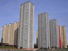
Like many cities in the UK, Glasgow witnessed the construction of high-rise housing in tower blocks in the 1960s,[7] intended to replace the decaying tenement buildings originally constructed in the 1800s for workers who migrated to meet the local demand for labour during the Industrial Revolution.
History
During the 19th century, tenement buildings were constructed to accommodate workers who migrated from the surrounding countryside, the Scottish Highlands, the rest of the United Kingdom, particularly Ireland,[8][9] and further afield (Italy, Lithuania, Poland) to smaller degrees, to feed the local demand for labour during the Industrial Revolution which saw the city's population and importance increase rapidly to the extent that it became the 'second city of the Empire'.[10] The massive demand outstripped new building and many tenements often became overcrowded and unsanitary.[11] Parts of inner city areas like Anderston, Cowcaddens, the Garngad, Townhead and particularly the Gorbals,[9] as well as parts of the industrialised East End (Bridgeton, the Calton, Camlachie, the Gallowgate) deteriorated into slums in which disease thrived.[10] Efforts to improve this housing situation, most successfully with the City Improvement Trust which was established in 1866, cleared the slums of the old town.[12] Over 15,000 houses were demolished in the early 1870s, but without equivalent provision of new housing stock.[13]:345
Subsequent urban renewal initiatives following World War II, such as those motivated by the Bruce Report,[20] and the Abercrombie Plan,[21] entailed the demolition of slum tenement areas, the development of new towns, the building of overspill estates on the periphery of the city, and the construction of tower blocks.[19] Several districts of the city were designated 'Comprehensive Development Areas'[22][19] with the intention to raze them and rebuild from scratch with entire communities dispersed. Although the new town option was accepted, with places such as East Kilbride and Cumbernauld being established,[19] the need for thousands of new homes was becoming ever more pressing – almost half of the dwellings in the city had been judged as overcrowded in the 1951 census[23] while in 1957, 97% of housing in the Gorbals was still described as 'unsatisfactory sanitorially'[21] – and with the Glasgow Corporation keen for as many citizens to remain as taxpayers within their boundaries as possible despite limited space and funds available, the overspill and tower proposals were eagerly pursued, in contrast with the trend of lower-density housing which had been preferred prior to the war but were considered to take too long to build and use too much land in comparison with the urgent need to replace so much of the inner city.
While the facilities in dwellings in the towers and the modern tenements were an improvement on the slum housing, the large 'schemes' lacked basic amenities and employment opportunities,[24] and were often cheaply built using pre-fabricated concrete construction methods which were ill-suited to the intemperate climate of Western Scotland. Damp quickly penetrated and spread within the new buildings which caused health problems; this was also the case with many of the tower blocks (or 'high flats' as they typically referred to by Glaswegians), many of which were surrounded by low-rise housing on a common design theme from idealised plans which seldom matched reality – in some cases, existing amenities in older districts had been swept away to provide space for the modern 'upgrades', which sometimes never materialised or were inadequate. Many residents struggled with the lack of provision made for child welfare and social needs such as hairdressing and clothing shops,[24] there were also issues arising from the lack of help given to older members of the community in adjusting to the new buildings and amenities. Some first generation 'emigrees' chose to return to their old neighbourhoods to socialise whenever possible, creating a strange situation where otherwise desolate environments such as post-demolition Gorbals retained thriving public houses on isolated corners, with their clientele having stayed loyal despite moving several miles away to estates with no such establishments. The condition of the schemes and the towers was not helped by the decline of the city's traditional industries in the same period, with breadwinners finding themselves out of work and their families isolated on the edge of town or fifteen floors up (sometimes both) in a city with low levels of car ownership, contributing to an increase in antisocial behaviour like gang fighting and vandalism, and the abuse of alcohol and drugs, all of which earned many parts of Glasgow a generalised reputation as hotbeds of violence and deprivation which should be avoided, in effect new slums in place of those they had been intended to replace just a few decades earlier.[32]
As demonstrated elsewhere in the UK, the tower blocks gradually deteriorated, attracting crime and fostering a reputation for being undesirable low cost housing. Because many of the towers were of a standard "off the peg" design, it meant that design flaws were replicated in several areas of the city. The cost of maintaining the buildings was far higher than anticipated, and while some tower blocks were upgraded in the 1980s with apex roofs (to combat damp), secured entry and external cladding; by the 1990s demolition was becoming the preferred solution over repair and renovation. While some of the initial tenants were happy living in the towers and chose to stay, the low desirability of the accommodation meant that those who were dissatisfied and moved out were typically replaced by 'problem' tenants with little other option whose lifestyles led to the issues worsening, more original tenants left and the downward cycle continued until some of the blocks were almost empty. A major turning point in the city's policy towards such "schemes" was signalled when the decision was taken to demolish the Hutchesontown C tower blocks in 1993 – once regarded as flagship developments of their time, but now viewed as a monument to the planning mistakes of the 1950s and 1960s.
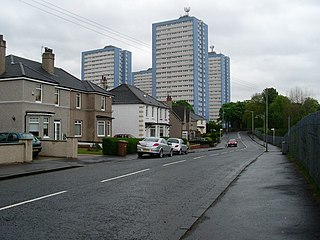
The now demolished Red Road estate came to symbolise the mistakes of the city's 1960s housing policy.
Meanwhile, the policy of tenement demolition was now considered to have been short-sighted, wasteful and largely unsuccessful. In the East End, the Glasgow Eastern Area Renewal (GEAR) scheme which began in the late 1970s demonstrated that the tenements, if sympathetically refurbished, could be turned back into viable housing of a higher quality than many of the post-war concrete estates and towers. Following the GEAR initiative, many of Glasgow's worst tenements in areas such as Govan and Springburn also were refurbished into desirable accommodation in the 1970s and 1980s[33] and the policy of demolition is considered to have destroyed many fine examples of a "universally admired architectural style",[5] although this traditional style survives in many districts (with variations in design and quality) including Battlefield, Cathcart, Crosshill, Cessnock, Dennistoun, East Pollokshields, Finnieston, Govanhill, Hillhead, Hyndland, Linthouse, Partick, Possilpark, Shawlands, Shettleston, Woodlands, Yoker and Yorkhill. They have outlasted the vast majority of the inter-war rehousing grade (lower quality material) blocks intended to replace them, with developments at Barrowfield, Blackhill, the Calton, Cowlairs, Hamiltonhill, Lilybank, 'Maryhill Valley', Moorepark[34]Oatlands and Teucharhill having to be rebuilt from scratch by the 2010s (pockets of this style remain at Battlefield, Bridgeton, Craigton, Germiston, Govanhill, Haghill, Ibrox, Riddrie, Scotstoun, Shawlands, Shettleston, Springburn etc., mostly refurbished or better appointed from the outset).
The Glasgow Housing Association took ownership of the housing stock from the city council on 7 March 2003, and began a £96million programme to clear and demolish many of the high-rise flats and refurbish others;[35] such programmes had already been implemented in most of the peripheral schemes, with some refurbishment and some replacement of tenements with individual houses, and this work also continued under the GHA and local housing co-operatives.
Glasgow tower blocks
The map and list concentrates on towers of at least 12 storeys in height built between the late 1950s and early 1970s within Glasgow. Also includes early 10-storey developments at Moss Heights and Toryglen due to their importance in the uptake of the method, but does not include numerous similar developments outside the city boundaries[lower-alpha 1] nor modern residential developments (e.g. Argyle Building, Glasgow Harbour, Lancefield Quay),[36][37][38] nor contemporary buildings with other uses (e.g. Glasgow College of Building and Printing, Elmbank Gardens, Livingstone Tower and The Pinnacle – the latter was originally a commercial property before being converted to residential use in the early 21st century).[39]
List of developments
As of 28 February 2019
Key:
= Existing development
= Partially existing development (some blocks demolished, figures are for original completed total).
= Demolished development
ABC(4) = Code for development name (number of towers).
↑ 14 Shaftesbury Street, 52 Shaftesbury Street (part of a development of several desk-access blocks, but no others tall enough to be considered a high-rise structure)
↑ 80 Charles Street – Wallace House, 90 Charles Street – Burns House, 140 Charles Street – Lomond House, 150 Charles Street – Nevis House, 160 Charles Street – Campsie House
↑ 37/49 Fountainwell Avenue – Tennant Heights, 2/4 Fountainwell Place – Eagle Heights, 16/18 Fountainwell Place – Barony Heights, 6/8 Fountainwell Square – Phoenix Heights, 2/4 Fountainwell Terrace – St Rollox Heights
↑ 3/5 Pinkston Drive – Pinkston Heights, 16/18 Pinkston Drive – Parson Heights, 17/19 Pinkston Drive – Huntingdon Heights, 31/35 Pinkston Drive – Crawfurd Heights, 32/34 Pinkston Drive – Hartfield Heights
The Gorbals is an area in the city of Glasgow, Scotland, and former burgh, on the south bank of the River Clyde. By the late 19th century, it had become densely populated; rural migrants and immigrants were attracted by the new industries and employment opportunities of Glasgow. At its peak, during the 1930s, the wider Gorbals district had swollen in population to an estimated 90,000 residents, giving the area a very high population density of around 100,000 per sq. mi. (40,000/km2). Redevelopment after WWII has taken many turns, and the area's population is substantially smaller today. The Gorbals was also home to 16 high rise flat blocks; only six are standing as of 2024, and two of them are set to come down some point this year.
Pollokshaws is an area on the South side of the city of Glasgow, Scotland. It is bordered by the residential neighbourhoods of Auldhouse to the east, Eastwood and Hillpark to the south and Shawlands to the north, with the Glasgow South Western Line railway and the open lands of Pollok Country Park to the west. The White Cart Water flows through the area.
Knightswood is a suburban district in Glasgow, containing three areas: Knightswood North or High Knightswood, Knightswood South or Low Knightswood, and Knightswood Park. It has a golf course and park, and good transport links with the rest of the city. Garscadden and Scotstounhill railway stations serve Low Knightswood while Westerton station serves High Knightswood. Knightswood is directly adjoined by the Anniesland, Blairdardie, Drumchapel, Garscadden, Jordanhill, Netherton, Scotstoun, Scotstounhill and Yoker areas of Glasgow, and by Bearsden in the north.
Cowcaddens is an area of the city of Glasgow, Scotland. It sits directly north of the city centre and is bordered by the newer area of Garnethill to the south-west and Townhead to the east.
Sir Robert Hogg Matthew, OBE FRIBA FRSE was a Scottish architect and a leading proponent of modernism.
Toryglen is a district in southern Glasgow, Scotland, falling within the Langside ward under Glasgow City Council. It is approximately two miles south of the city centre, bounded to the west by Mount Florida, the north-west by Polmadie, to the north-east by the West Coast Main Line railway and the M74 motorway the south by King's Park, and immediately to the east by the town of Rutherglen.
Germiston is a neighbourhood in the city of Glasgow, Scotland, north of the River Clyde.
Sandyhills is an area of the Scottish city of Glasgow. It is situated north of the River Clyde and has fallen within the Shettleston ward of Glasgow City Council since 2007.
Sighthill is a neighbourhood in the Scottish city of Glasgow. It is situated north of the River Clyde and is part of the wider Springburn district in the north of the city. It is bordered to the north by Cowlairs, to the east by the Springburn Bypass road and the Royston neighbourhood, to the west by the Glasgow to Edinburgh via Falkirk Line and to the south by the Townhead interchange of the M8 Motorway.
Govanhill is an area of Glasgow, Scotland, situated south of the River Clyde between Pollokshields, the Gorbals, Strathbungo, Crosshill, Polmadie and Queen's Park. Historically part of Renfrewshire, Govanhill had the status of a police burgh between 1877 and 1891 before becoming part of the City of Glasgow. Since 2007, it has fallen under the Southside Central ward of Glasgow City Council. A previous smaller ward named Govanhill had boundaries of Dixon Avenue and Dixon Road to the south, Victoria Road to the west, Butterbiggins Road to the north and Aikenhead Road to the east.
Hutchesontown is an inner-city area in Glasgow, Scotland. Mostly residential, it is situated directly south of the River Clyde and forms part of the wider historic Gorbals district, which is covered by the Southside Central ward under Glasgow City Council.
Laurieston is a district in the Gorbals area of the Scottish city of Glasgow. It is situated south of the River Clyde. It derives its name from James Laurie who, along with his brother, developed a large part of the district in the early 19th century.
Scotstounhill is a small area situated in western Glasgow, between south Knightswood and Scotstoun. Housing is mainly in a terraced or villa style, although several high rise flats can be found in the area. These were built near to the site of the Scotstoun House mansion.
The Bruce Report is the name commonly given to the First Planning Report to the Highways and Planning Committee of the Corporation of the City of Glasgow published in March 1945. It influenced an intensive programme of regeneration and rebuilding efforts which took place in the city and surroundings from the mid-1950s and lasted until the late 1970s. The author was Robert Bruce, Glasgow Corporation Engineer at the time.
The Red Road Flats were a mid-twentieth-century high-rise housing complex located between the districts of Balornock and Barmulloch in the northeast of the city of Glasgow, Scotland. The estate originally consisted of eight multi-storey blocks of steel frame construction. All were demolished by 2015. Two were "slabs", much wider in cross-section than they are deep. Six were "points", more of a traditional tower block shape. The slabs had 28 floors, the point blocks 31, and taken together, they were designed for a population of 4,700 people. The point blocks were among the tallest buildings in Glasgow at 89 metres (292 ft), second in overall height behind the former Bluevale and Whitevale Towers in Camlachie. The 30th floor of the point blocks were the highest inhabitable floor level of any building in Glasgow.
Hutchesontown C was a Comprehensive Development Area (CDA) of an area of Hutchesontown, a district in the city of Glasgow, Scotland. Its centrepiece were two Brutalist 20-storey slab blocks at 16-32 Queen Elizabeth Square, designed by Sir Basil Spence and containing 400 homes. Acclaimed by architects and modernists, the flats became riddled with damp and infestations, which could not be cured even with a major renovation in the late 1980s. They were demolished in 1993, with the demolition contractor using twice the amount of explosive necessary to destroy the building, killing a female spectator in the process.
The Bluevale and Whitevale Towers were twin tower block flats situated in the Camlachie district within the East End of Glasgow, Scotland. Officially named 109 Bluevale Street and 51 Whitevale Street, and often nicknamed the Gallowgate Twins or the Camlachie Twin Towers, the two towers were for a time the tallest buildings in Scotland.
Muirhouse is a residential suburb in the south-east of Motherwell, North Lanarkshire, Scotland, coming under the Motherwell South East & Ravenscraig council ward and bordering the Flemington neighbourhood in the town, plus the Craigneuk and Netherton areas of Wishaw. It consists of thirteen tower blocks, amidst low rise flats and numerous houses.
Whitlawburn is a residential area in the town of Cambuslang in South Lanarkshire, Scotland. It is located south of the town centre on high ground overlooking the Greater Glasgow urban area.
↑ Gale, Lindsay (25 February 2015). "First 'Gallowgate Twin' shrinks". Demolition and Recycling International. KHL. Archived from the original on 12 March 2015. Retrieved 17 February 2019.
This page is based on this Wikipedia article Text is available under the CC BY-SA 4.0 license; additional terms may apply. Images, videos and audio are available under their respective licenses.