
Culross (/ˈkurəs/) is a village and former royal burgh, and parish, in Fife, Scotland.

Roxburghshire or the County of Roxburgh is a historic county and registration county in the Southern Uplands of Scotland. It borders Dumfriesshire to the west, Selkirkshire and Midlothian to the northwest, and Berwickshire to the north. To the southwest it borders Cumberland and to the southeast Northumberland, both in England.

Strathaven is a historic market town in South Lanarkshire, Scotland and is the largest settlement in Avondale. It is 7.5 kilometres south of Hamilton. The Powmillon Burn runs through the town centre, and joins the Avon Water to the east of the town.

Inchinnan is a small village in Renfrewshire, Scotland. The village is located on the main A8 road between Renfrew and Greenock, just south east of the town of Erskine.

Abernethy is a village and former burgh in the Perth and Kinross council area and historic county of Perthshire, in the east central Lowlands of Scotland.

Stonesfield is a village and civil parish about 5 miles (8 km) north of Witney in Oxfordshire, and about 10 miles (17 km) north-west of Oxford. The village is on the crest of an escarpment. The parish extends mostly north and north-east of the village, in which directions the land rises gently and then descends to the River Glyme at Glympton and Wootton about 3 miles (5 km) to the north-east. South of Stonesfield, below the escarpment, is the River Evenlode which touches the southern edge of the parish. At the centre of Stonesfield stands the 13th-century church of St James the Great as well as a Wesleyan chapel, Stonesfield Methodist Church, slightly further west. The village is known for Stonesfield slate, a form of Cotswold stone mined particularly as a roofing stone and also a rich source of fossils. The architecture in Stonesfield features many old Cotswold stone properties roofed with locally mined slate along with some late 20th-century buildings and several properties under construction. The 2011 Census recorded the parish's population as 1,527.

Old Kilpatrick, is a village in West Dunbartonshire, Scotland. The name Old Kilpatrick is said to be derived from St. Patrick ostensibly being born here. It has an estimated population of 4,820. It belonged to the parish of Old Kilpatrick which itself was only a few thousand people strong.

Law is a village situated between Carluke and Wishaw in South Lanarkshire, Scotland with a population of around 3,000. The village lies on the border of North Lanarkshire.

Morebattle is a village in the Scottish Borders area of Scotland, on the B6401, seven miles south of Kelso, Scottish Borders, beside the Kale Water, a tributary of the River Teviot. The St. Cuthbert's Way long distance footpath passes through the village.

Killearn – is a small village of approximately 1700 people in the Stirling council area of Scotland.

Handforth is a town and civil parish in Cheshire, England, 9 miles (14 km) south of Manchester city centre. The population at the 2011 census was 6,266. In the 1960s and 1970s, two overspill housing estates, Spath Lane in Handforth, and Colshaw Farm nearby in Wilmslow, were built to re-house people from inner city Manchester. It lies between Wilmslow, Heald Green, Stanley Green and Styal and forms part of the Greater Manchester Built-up Area.
Oxnam is a village near Jedburgh, in Roxburghshire in the Scottish Borders area of Scotland. It is a primarily residential village.
Dairsie, or Osnaburgh, is a village and parish in north-east Fife, Scotland. It is 3 miles (4.8 km) south-southwest of Leuchars Junction, and 3 miles (4.8 km) east-northeast of Cupar on the A91 Stirling to St Andrews road. The village grew out of two smaller settlements, and developed principally around the industry of weaving. Since the late twentieth century it has become a dormitory settlement for nearby towns.
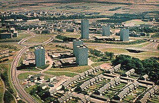
Cumbernauld is a large town in the historic county of Dunbartonshire and council area of North Lanarkshire, Scotland. It is the tenth most-populous locality in Scotland and the most populated town in North Lanarkshire, positioned in the centre of Scotland's Central Belt. Geographically, Cumbernauld sits between east and west, being on the Scottish watershed between the Forth and the Clyde; however, it is culturally more weighted towards Glasgow and the New Town's planners aimed to fill 80% of its houses from Scotland's largest city to reduce housing pressure there.
Mowhaugh is a hamlet and farm steading near the Calroust Burn and the Bowmont Water, near Morebattle, in the Scottish Borders area of Scotland, and in the former Roxburghshire. It is situated about 5 miles (8 km) from the Anglo-Scottish Border.

Crailing is a village on the A698, in Teviotdale, 4m east of Jedburgh in the Scottish Borders area of Scotland, in the historic county of Roxburghshire.

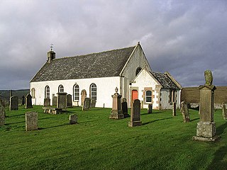
Linton is a small village in the Scottish Borders area of Scotland. It is situated a mile north of the village of Morebattle.
Makerstoun is a parish in the Scottish Borders area of Scotland, as well as the historic county of Roxburghshire, 4 miles (6 km) south-west of Kelso.
Archibald Campbell Craig MC (1888–1985) was a Scottish minister and biblical scholar who served as Moderator of the General Assembly of the Church of Scotland in 1961. He was affectionately known as Archie Craig.

