Huntington, Virginia

Last updated

Huntington, Virginia
HuntingtonfromMetro.jpg
Huntington as seen from the Washington Metro; the lower parking deck of Huntington Station may be seen in the foreground.
Fairfax County Virginia Incorporated and Unincorporated Areas Huntington highlighted.svg
Location of Huntington in Fairfax County, Virginia
USA Virginia Northern location map.svg
Red pog.svg
Huntington, Virginia
USA Virginia location map.svg
Red pog.svg
Huntington, Virginia
Usa edcp location map.svg
Red pog.svg
Huntington, Virginia
Coordinates: 38°47′33″N77°4′20″W / 38.79250°N 77.07222°W / 38.79250; -77.07222
CountryUnited States
State Virginia
County Fairfax
Area
  Total1.1 sq mi (2.9 km2)
  Land1.1 sq mi (2.8 km2)
  Water0.04 sq mi (0.1 km2)
Elevation
66 ft (20 m)
Population
 (2020)
  Total13,749
  Density10,368/sq mi (4,003.3/km2)
Time zone UTC−5 (Eastern (EST))
  Summer (DST) UTC−4 (EDT)
FIPS code 51-39064 [1]
GNIS feature ID1493118 [2]

Huntington is a census-designated place (CDP) in Fairfax County, Virginia, United States. The population was 11,267 at the 2010 census. [3] It is located next to the southern border of the city of Alexandria and is part of the Washington metropolitan area. Its main component is the namesake Huntington subdivision, a late-1940s neighborhood of mainly duplex homes.

Contents

In June 2006, the lower-lying northern section was ravaged by floods due to a torrential rainstorm that sent adjoining Cameron Run over its banks. Nevertheless, it remains popular with first-time home buyers due largely to its proximity to the Huntington Metro station, the southern terminus of Metrorail's Yellow Line. There are also several high-rise apartment and condominium complexes on and near U.S. Route 1 where much of the CDP's population resides. The area is included in ZIP code 22303 and has an Alexandria mailing address, although it is outside the city limits.

Geography

Huntington is located in southeastern Fairfax County at 38°47′33″N77°4′20″W / 38.79250°N 77.07222°W / 38.79250; -77.07222 (38.792563, 77.072120). [4] It is bordered to the north by the city of Alexandria, to the southeast by Belle Haven, and to the west by Rose Hill. U.S. Route 1 forms the border between Huntington and Belle Haven, and the boundary with Rose Hill is drawn to follow Poag Street, Shaffer Drive, Florence Lane, and Telegraph Road. Downtown Alexandria (Old Town) is 2 miles (3 km) to the northeast, and downtown Washington, D.C. is 10 miles (16 km) to the north.

According to the United States Census Bureau, the Huntington CDP has a total area of 1.1 square miles (2.9 km2), of which 1.1 square miles (2.8 km2) is land and 0.04 square miles (0.1 km2), or 3.47%, is water. [3]

Demographics

As of the census [1] of 2000, there were 8,325 people, 4,615 households, and 1,675 families residing in the CDP. The population density was 10,665.6 inhabitants per square mile (4,118.0/km2). There were 4,860 housing units at an average density of 6,226.4 per square mile (2,404.0/km2). The racial makeup of the CDP was 64.95% White, 16.74% African American, 0.40% Native American, 7.02% Asian, 0.16% Pacific Islander, 6.91% from other races, and 3.83% from two or more races. Hispanic or Latino of any race were 14.01% of the population.

Apartment complex along US Rte. 1 in Huntington Huntington Apartments.jpg
Apartment complex along US Rte. 1 in Huntington

There were 4,615 households, out of which 11.9% had children under the age of 18 living with them, 26.8% were married couples living together, 6.7% had a female householder with no husband present, and 63.7% were non-families. 52.6% of all households were made up of individuals, and 7.6% had someone living alone who was 65 years of age or older. The average household size was 1.80 and the average family size was 2.75.

In the CDP, the population was spread out, with 13.0% under the age of 18, 10.0% from 18 to 24, 43.2% from 25 to 44, 23.4% from 45 to 64, and 10.4% who were 65 years of age or older. The median age was 36 years. For every 100 females, there were 101.9 males. For every 100 females age 18 and over, there were 100.9 males.

The median income for a household in the CDP was $52,364, and the median income for a family was $62,228. Males had a median income of $43,429 versus $36,563 for females. The per capita income for the CDP was $36,945. About 6.8% of families and 7.7% of the population were below the poverty line, including 19.0% of those under age 18 and 0.6% of those age 65 or over.

Related Research Articles

<span class="mw-page-title-main">San Carlos, Arizona</span> CDP in Gila County, Arizona

San Carlos is a census-designated place (CDP) in Gila County, Arizona, United States. The population was 4,038 at the 2010 census, up from 3,716 in 2000.

Upper Grand Lagoon is a census-designated place (CDP) in Bay County, Florida, United States. The population was 13,963 at the 2010 census. It is part of the Panama City–Lynn Haven–Panama City Beach Metropolitan Statistical Area.

<span class="mw-page-title-main">Lake of the Woods, Illinois</span> Census-designated place in Illinois, United States

Lake of the Woods is a census-designated place in Champaign County, Illinois, United States. The population was 2,403 at the 2020 census. Lake of the Woods is located in Mahomet Township and mostly surrounded by the northeast part of the village of Mahomet.

<span class="mw-page-title-main">Potomac Heights, Maryland</span> Census-designated place in Maryland, United States

Potomac Heights is a census-designated place (CDP) in Charles County, Maryland, United States. The population was 1,117 at the 2010 census. It has a volunteer fire department and numerous older rambler homes built for workers at the nearby U.S. Navy munitions plant in Indian Head.

<span class="mw-page-title-main">Halesite, New York</span> Hamlet and census-designated place in New York, United States

Halesite is a hamlet and census-designated place (CDP) in the Town of Huntington in Suffolk County, on the North Shore of Long Island, in New York, United States. The population was 2,498 at the 2010 census.

<span class="mw-page-title-main">Lincolnville, Pennsylvania</span> Census-designated place in Pennsylvania, United States

Lincolnville is a census-designated place in Crawford County, Pennsylvania, United States. The population was 96, as per the 2010 census.

New Kingstown is a census-designated place (CDP) in Silver Spring Township, Cumberland County, Pennsylvania, United States. The population was 495 at the 2010 census. It is part of the Harrisburg–Carlisle metropolitan statistical area.

<span class="mw-page-title-main">Belle Haven, Fairfax County, Virginia</span> Census-designated place in Virginia, United States

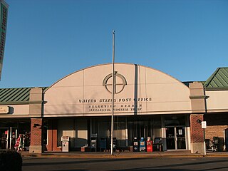
Belle Haven is a census-designated place (CDP) in Fairfax County, Virginia, United States. Nearby CDPs are Huntington (northwest), Groveton (southwest) and Fort Hunt (south). The population of Belle Haven was 6,851 at the 2020 census.

<span class="mw-page-title-main">Fort Hunt, Virginia</span> Census-designated place in Virginia, United States

Fort Hunt is a census-designated place (CDP) in Fairfax County, Virginia, United States. The area is named after Fort Hunt, which was built on the bank of the Potomac River in 1897 to defend Washington, D.C. from naval attack and is now a public park. The area is also notable for its high population of senior citizens and for being one of the first suburbs in wealthy Fairfax County. The population was 17,231 at the 2020 census.

<span class="mw-page-title-main">Groveton, Virginia</span> Census-designated place in Virginia, United States

Groveton is a census-designated place (CDP) in Fairfax County, Virginia, United States. The population was 14,598 at the 2010 census, down from 21,296 in 2000 due to a reduction in area. Located south of the city of Alexandria, it encompasses numerous neighborhoods including Groveton, Bucknell Manor, Stoneybrooke, and portions of Hollin Hills. Huntley Meadows Park, Fairfax County's largest park, is located in the southwest part of the CDP.

<span class="mw-page-title-main">Lincolnia, Virginia</span> Census-designated place in Virginia, United States

Lincolnia is a census-designated place (CDP) in Fairfax County, Virginia, United States. The population was 22,828 at the 2010 census, an increase of over 44% from 2000.

<span class="mw-page-title-main">Merrifield, Virginia</span> Census-designated place in Virginia, United States

Merrifield is a census-designated place (CDP) in Fairfax County, Virginia, United States. The population was 20,488 at the 2020 census.

<span class="mw-page-title-main">Mount Vernon, Virginia</span> Census-designated place in Virginia, United States

Mount Vernon is a census-designated place (CDP) and unincorporated community in Fairfax County, Virginia, United States. The population was 12,914 at the 2020 census. Primarily due to its historical significance and natural recreation and beauty, the Mount Vernon area receives over one million tourists each year.

<span class="mw-page-title-main">Newington, Virginia</span> Census-designated place in Virginia, United States

Newington is a census-designated place (CDP) in Fairfax County, Virginia, United States. As of the 2020 census, the population was 13,223. The population was 12,943 at the 2010 census. The 2010 census showed a significant decrease after half the population was split off to the newly created Newington Forest CDP.

<span class="mw-page-title-main">Yorkshire, Virginia</span> CDP in Virginia, United States

Yorkshire is a census-designated place (CDP) in Prince William County, Virginia, United States. It is an annex of Manassas, Virginia. The population was 6,732 at the 2000 census.

<span class="mw-page-title-main">Spotsylvania Courthouse, Virginia</span> Unincorporated census-designated place in Virginia, United States

Spotsylvania Courthouse is a census-designated place (CDP) and the county seat of Spotsylvania County, Virginia, United States, located 10 miles (16 km) southwest of Fredericksburg. Recognized by the U.S. Census Bureau as a census designated place (CDP), the population was 5,610 at the 2020 census.

<span class="mw-page-title-main">Aquia Harbour, Virginia</span> CDP in Virginia, United States

Aquia Harbour is a census-designated place (CDP) in Stafford County, Virginia, United States, 13 miles (21 km) north of Fredericksburg. The population was 6,727 at the 2010 census. Aquia Church, erected in 1757 and now a National Historic Landmark, is located west of the community.

<span class="mw-page-title-main">Pea Ridge, West Virginia</span> Census-designated place in West Virginia, United States

Pea Ridge is a census-designated place in Cabell County, West Virginia, United States. As of the 2020 census, the population was 6,602. It is part of the Huntington–Ashland metropolitan area.

<span class="mw-page-title-main">Mallory, West Virginia</span> Census-designated place in West Virginia, United States

Mallory is a census-designated place (CDP) in Logan County, West Virginia, United States. The population was 1,654 at the 2010 census. The CDP contains the unincorporated communities, from west to east, of Huff Junction, Mallory, Davin, Mineral City, Claypool, Combs Addition, and Gillman Bottom.

<span class="mw-page-title-main">Plattekill (CDP), New York</span> CDP in New York, United States

Plattekill is a hamlet in Ulster County, New York, United States. The population was 1,296 at the 2020 census. The community, as is the town, is named after a local stream, the Platte Kill.

References

  1. 1 2 "U.S. Census website". United States Census Bureau . Retrieved January 31, 2008.
  2. "US Board on Geographic Names". United States Geological Survey. October 25, 2007. Retrieved January 31, 2008.
  3. 1 2 "Geographic Identifiers: 2010 Demographic Profile Data (G001): Huntington CDP, Virginia". U.S. Census Bureau, American Factfinder. Retrieved October 6, 2016.[ dead link ]
  4. "US Gazetteer files: 2010, 2000, and 1990". United States Census Bureau. February 12, 2011. Retrieved April 23, 2011.