Huron, Ohio

Last updated

Huron, Ohio
Huron Harbor Light OH.jpg
Harbor Light in Huron
Motto: 
"A Great Lake Place"
OHMap-doton-Huron.png
Location of Huron, Ohio
Map of Erie County Ohio Highlighting Huron City.png
Location of Huron in Erie County
Coordinates: 41°23′59″N82°33′54″W / 41.39972°N 82.56500°W / 41.39972; -82.56500
CountryUnited States
State Ohio
County Erie
Government
  Type Council-manager
   Mayor Monty Tapp
   City Manager Matt Lasko
Area
[1]
  Total7.91 sq mi (20.48 km2)
  Land4.94 sq mi (12.80 km2)
  Water2.96 sq mi (7.67 km2)
Elevation
[2]
584 ft (178 m)
Population
 (2020)
  Total6,922
  Density1,400.36/sq mi (540.65/km2)
Time zone UTC-5 (Eastern (EST))
  Summer (DST) UTC-4 (EDT)
ZIP Codes
44839
Area code(s) 419 and 567
FIPS code 39-37016
GNIS ID1056347 [2]
Website http://www.cityofhuron.org/

Huron is a city in Erie County, Ohio, United States, located at the mouth of the Huron River on Lake Erie. The population was 6,922 at the 2020 census. It is part of the Sandusky micropolitan area.

Contents

History

Huron Township was at the center of the "Firelands" region of the Connecticut Western Reserve. The first permanent settler in the area that became Huron Township was a Quebec-born trapper, trader and interpreter named John Baptiste Flammand (or, "Flemming"; and often misspelled "Flemmond"), who established a trading post about 1805, approx. two miles inland upon the east bank of the Huron River. Other French traders had preceded him, including Gabriel Hunot in the 1780s.

Huron Township was established in 1809. Huron Village was later established between 1821 and 1824, when a town plat was surveyed, and port facilities at the mouth of the Huron River were developed; and the village quickly became a major shipbuilding center in the 1830s. [The current community of Huron is sometimes mistaken to have been the same as the "town plat of Huron" (also known as "the old County Seat" village), which was established about 1814, and was actually within the present Milan Township (formerly known as Avery Township before 1821). [3] ]

The Wheeling and Lake Erie Railroad greatly expanded Huron's port on the east bank of the Huron River beginning in 1880. The first cargo of iron ore at the W&LE docks was received May 21, 1884. The port is still in use today, accepting cargoes of iron ore and limestone from lake freighters. Huron was also the home port of several commercial fishing fleets before unbridled lake pollution decimated the industry on Lake Erie by the early 1970s. Water quality in Lake Erie has greatly improved as a result of strong environmental controls since then and sport fishing has increased in popularity in the area. However, the Lake faces new threats from algal blooms and several invasive species such as zebra mussels and Asian carp that may impact sport fishing in the future.

Geography

Mouth of the Huron River Ohio-Huron River.jpg
Mouth of the Huron River

Huron is located at 41°23′59″N82°33′54″W / 41.39972°N 82.56500°W / 41.39972; -82.56500 (41.399669, -82.564974). [4]

According to the United States Census Bureau, the city has a total area of 7.73 square miles (20.02 km2), of which 4.84 square miles (12.54 km2) is land and 2.89 square miles (7.49 km2) is water. [5]

Demographics

Historical population
CensusPop.Note
1840 488
1860 802
1870 697−13.1%
1880 1,03848.9%
1890 1,38032.9%
1900 1,70823.8%
1910 1,7562.8%
1920 1,703−3.0%
1930 1,699−0.2%
1940 1,8277.5%
1950 2,51537.7%
1960 5,197106.6%
1970 6,89632.7%
1980 7,1233.3%
1990 7,030−1.3%
2000 7,95813.2%
2010 7,149−10.2%
2020 6,922−3.2%
2021 (est.)6,860−0.9%
Sources: [6] [7] [8] [9] [10] [11] [12] [13]

The median income for a household in the city was $59,766, and the median income for a family was $73,068. Male full-time, year-round workers had a median income of $51,003 versus $41,667 for female full-time, year-round workers. The per capita income for the city was $29,213. About 2.5% of families and 5% of the population were below the poverty line, including 2.6% of those under age 18 and 5.6% of those age 65 or over.

2010 Census

As of the 2010 census, there were 7,149 people, 3,073 households, and 1,988 families residing in the city. The population density was 1,477.1 inhabitants per square mile (570.3/km2). There were 3,710 housing units at an average density of 766.5 per square mile (295.9/km2). The racial makeup of the city was 96.4% White, 0.9% African American, 0.3% Native American, 0.5% Asian, 0.3% from other races, and 1.5% from two or more races. Hispanic or Latino of any race were 2.3% of the population.

There were 3,073 households, of which 29.1% had children under the age of 18 living with them, 49.6% were married couples living together, 10.8% had a female householder with no husband present, 4.2% had a male householder with no wife present, and 35.3% were non-families. 29.5% of all households were made up of individuals, and 11.9% had someone living alone who was 65 years of age or older. The average household size was 2.30 and the average family size was 2.84.

The median age in the city was 43.9 years. 22.7% of residents were under the age of 18; 6.7% were between the ages of 18 and 24; 22% were from 25 to 44; 30.2% were from 45 to 64; and 18.4% were 65 years of age or older. The gender makeup of the city was 48.1% male and 51.9% female.

Economy

Commercial and industrial development of Huron had historically been centered around the riverfront port area. By the early 1960s a busy downtown business district had developed, serving local residents and summer tourists. However, with improvements to U.S. Route 6 and Ohio Route 2 bypassing the downtown area and enabling quicker travel to larger neighboring cities, downtown Huron went into decline. Starting in 1967, the City of Huron embarked on a controversial urban renewal program with funding from various programs of the U.S. federal government, such as the United States Department of Housing and Urban Development, and the State of Ohio. The city purchased, in some cases by eminent domain, and demolished 38 commercial buildings and private homes. It then built a municipal marina, called the Huron Boat Basin, as the focal point of a new downtown. While the "Boat Basin" has become a popular community park and gathering place, extensive redevelopment of the downtown area did not occur as quickly as envisioned. New industry and commercial development has more recently occurred on the southern and western city limits and suburbs.

ConAgra site renewal

On July 18, 2006, the Ohio Department of Natural Resources (ODNR) announced the purchase of the ConAgra Foods facility in Huron. Concurrently, ConAgra Foods announced the closure of the grain elevator. The 19.8-acre (80,000 m2) parcel is a key piece of Huron's waterfront. The Ohio Department of Natural Resources (ODNR), Division of Watercraft has completed a public boating and fishing access site with launch ramps, docks and parking facilities. The City of Huron assumed title to the former grain silos and flour mill and received a grant to demolish the building, which was completed in August 2012. It envisions a future riverfront development to include restaurants, retail stores, condominiums and greenspace. [14]

On January 8, 2012, much of the former Con-Agra mill structure was demolished by implosion in a public event attracting media attention and a large crowd. The former grain silos were removed by manual demolition. [15]

Education

Primary and secondary

The Huron City School District has three schools for each level of public education:

Huron City Schools sports teams are known as the "Tigers". The Huron Tigers have recorded numerous athletic successes for both boys' and girls' scholastic sports competitions. [16] [17]

Postsecondary

BGSU Firelands, a branch campus of Bowling Green State University, is located just west of the city limits. A separate college of the Bowling Green State University system, BGSU Firelands has been a regional campus of Bowling Green since 1968. Over 2,000 students in 2006 were enrolled for a wide variety of associate, bachelors and graduate degree programs. Huron was also the home of the "Huron Playhouse", formerly a division of Bowling Green State University's Department of Theater and Film before becoming an independent, non-profit corporation.

Related Research Articles

<span class="mw-page-title-main">Sandusky County, Ohio</span> County in Ohio, United States

Sandusky County is a county located in the northwestern part of the U.S. state of Ohio. As of the 2020 census, the population was 58,896. Its county seat and largest city is Fremont. The county was formed on February 12, 1820, from portions of Huron County.

<span class="mw-page-title-main">Lorain County, Ohio</span> County in Ohio, United States

Lorain County is a county in the northeastern part of the U.S. state of Ohio As of the 2020 census, the population was 312,964. Its county seat is Elyria, and its largest city is Lorain.

<span class="mw-page-title-main">Huron County, Ohio</span> County in Ohio, United States

Huron County is a county located in the U.S. state of Ohio. As of the 2020 census, the population was 58,565. Its county seat is Norwalk. The county was created in 1809 and later organized in 1815.

<span class="mw-page-title-main">Erie County, Ohio</span> County in Ohio, United States

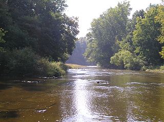
Erie County is a county located in the northern portion of the U.S. state of Ohio. As of the 2020 census, the population was 75,622. Its county seat and largest city is Sandusky. The county is named for the Erie tribe, whose name was their word for "wildcat". It was formed in 1838 from the northern third of Huron County and a portion of Sandusky County.

<span class="mw-page-title-main">Commerce Township, Michigan</span> Charter township in Michigan, United States

Commerce Township, officially the Charter Township of Commerce, is a charter township of Oakland County in the U.S. state of Michigan. The population was 40,186 at the 2010 census.

<span class="mw-page-title-main">Euclid, Ohio</span> City in Ohio, United States

Euclid is a city in Cuyahoga County, Ohio, United States. Located on the southern shore of Lake Erie, it is an inner ring suburb of Cleveland. The population was 49,692 at the 2020 census, making it the fourth largest city in Cuyahoga County.

<span class="mw-page-title-main">New London, Ohio</span> Village in Ohio, United States

New London is a village in Huron County, Ohio, United States. The population was 2,416 at the 2020 census.

<span class="mw-page-title-main">Norwalk, Ohio</span> City in Ohio, United States

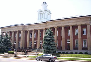
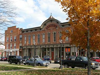
Norwalk is a city in and the county seat of Huron County, Ohio, United States. The population was 17,068 at the 2020 census. The city is the center of the Norwalk micropolitan area and part of the Cleveland–Akron–Canton combined statistical area. Norwalk is located approximately 10 miles (16 km) south of Lake Erie, 51 miles (82 km) west/southwest of Cleveland, 59 miles (95 km) southeast of Toledo, and 58 miles (93 km) west/northwest of Akron.

<span class="mw-page-title-main">Willard, Ohio</span> City in Ohio, United States

Willard is a city in southwestern Huron County, Ohio, United States, approximately 14 miles (23 km) southwest of Norwalk. The population was 6,197 at the 2020 census.

<span class="mw-page-title-main">Lorain, Ohio</span> City in Ohio, United States

Lorain is a city in Lorain County, Ohio, United States. It is located in Northeast Ohio on Lake Erie at the mouth of the Black River, about 25 miles (40 km) miles west of Cleveland. As of the 2020 census, the city had a population of 65,211, making it Ohio's ninth-largest city, the third-largest in Greater Cleveland, and the largest in Lorain County by population.

<span class="mw-page-title-main">Port Clinton, Ohio</span> City in Ohio, United States

Port Clinton is a city in and the county seat of Ottawa County, Ohio, United States, located at the mouth of the Portage River on Lake Erie. The population was 6,025 at the 2020 census. It is the principal city of the Port Clinton micropolitan area, about 34 miles (55 km) southeast of Toledo.

<span class="mw-page-title-main">McKean Township, Pennsylvania</span> Township in Pennsylvania, United States

McKean Township is a township in Erie County, Pennsylvania, United States. The population was 4,435 at the 2020 census, up from 4,409 at the 2010 census, down from 4,619 in 2000.

<span class="mw-page-title-main">Bellevue, Ohio</span> City in Ohio, United States

Bellevue is a city in Erie, Huron, Seneca, and Sandusky counties in the U.S. state of Ohio, located 61 miles southwest of Cleveland and 45 miles southeast of Toledo. The population was 8,249 at the 2020 census. The National Arbor Day Foundation has designated Bellevue as a Tree City USA.

<span class="mw-page-title-main">Milan, Ohio</span> Village in Ohio, United States

Milan is a village in Erie and Huron counties in the U.S. state of Ohio. The population was 1,371 at the 2020 census. It is best known as the birthplace and childhood home of Thomas Edison.

<span class="mw-page-title-main">Vermilion, Ohio</span> City in Ohio, United States

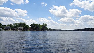
Vermilion is a city in Erie and Lorain Counties in the U.S. state of Ohio, on Lake Erie. Its population was 10,659 at the 2020 census. Located about 35 miles west of Cleveland and 17 miles east of Sandusky, it is part of the Cleveland metropolitan area and Sandusky micropolitan area.

<span class="mw-page-title-main">Oxford Township, Erie County, Ohio</span> Township in Ohio, United States

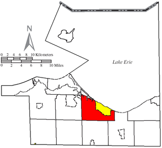
Oxford Township is one of the nine townships of Erie County, Ohio, United States. It is part of the Sandusky, Ohio micropolitan statistical area and the Cleveland-Akron-Canton Combined Statistical Area. The 2020 census recorded 1,140 residents.

<span class="mw-page-title-main">Danbury Township, Ohio</span> Township in Ohio, United States

Danbury Township is one of the twelve townships of Ottawa County, Ohio, United States. The 2020 census found 4,924 people in the township.

<span class="mw-page-title-main">Huron Township, Erie County, Ohio</span> Township in Ohio, United States

Huron Township is one of the nine townships of Erie County, Ohio, United States. It is part of the Sandusky, Ohio metropolitan statistical area, with the city of Sandusky to the northwest. The township sits along the southwestern shoreline of Lake Erie, one of the Great Lakes. As of the 2020 census the population was 10,724.

<span class="mw-page-title-main">Lyme Township, Huron County, Ohio</span> Township in Ohio, United States

Lyme Township is one of the nineteen townships of Huron County, Ohio, United States. As of the 2020 census the population of the township was 873.

<span class="mw-page-title-main">Sandusky, Ohio</span> City in Erie County, Ohio, United States

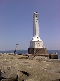
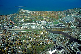
Sandusky is a city in and the county seat of Erie County, Ohio, United States. Situated along the southern shore of Lake Erie, Sandusky is located roughly midway between Toledo and Cleveland. According to 2020 census, the city had a population of 25,095, and the Sandusky metropolitan area had 115,986 residents.

References

  1. "ArcGIS REST Services Directory". United States Census Bureau. Retrieved September 20, 2022.
  2. 1 2 "US Board on Geographic Names". United States Geological Survey. October 25, 2007. Retrieved January 31, 2008.
  3. Fire Lands Pioneer series; 1858-1913 Firelands Historical Society
  4. "US Gazetteer files: 2010, 2000, and 1990". United States Census Bureau. February 12, 2011. Retrieved April 23, 2011.
  5. "US Gazetteer files 2010". United States Census Bureau. Archived from the original on January 12, 2012. Retrieved January 6, 2013.
  6. "Population of Civil Divisions Less than Counties" (PDF). Statistics of the Population of the United States at the Ninth Census. U.S. Census Bureau. 1870. Retrieved April 26, 2020.
  7. "Population of Civil Divisions Less than Counties" (PDF). Statistics of the Population of the United States at the Tenth Census. U.S. Census Bureau. 1880. Retrieved November 28, 2013.
  8. "Population: Ohio" (PDF). 1910 U.S. Census. U.S. Census Bureau. Retrieved November 28, 2013.
  9. "Population: Ohio" (PDF). 1930 US Census. U.S. Census Bureau. Retrieved November 28, 2013.
  10. "Number of Inhabitants: Ohio" (PDF). 18th Census of the United States. U.S. Census Bureau. 1960. Retrieved April 26, 2020.
  11. "Ohio: Population and Housing Unit Counts" (PDF). U.S. Census Bureau. Retrieved November 22, 2013.
  12. "U.S. Census website". United States Census Bureau . Retrieved January 31, 2008.
  13. "Huron city, Ohio". census.gov. Retrieved July 1, 2022.
  14. "July 2006 - Huron Access". Archived from the original on February 4, 2010. Retrieved January 18, 2014.
  15. http://www.cityofhuron.org/files/2012-07-06-Huron%202020%20Vision.pdf, p.66.
  16. Baker, Sarah. "Huron wins fourth state title..." Sandusky Register. Sandusky Newspapers, Inc. Retrieved November 8, 2014.
  17. "Huron Tiger Volleyball Win Division III State Championship | Huron Insider". November 16, 2020. Retrieved November 27, 2020.