A broch is an Iron Age drystone hollow-walled structure found in Scotland. Brochs belong to the classification "complex Atlantic roundhouse" devised by Scottish archaeologists in the 1980s. Their origin is a matter of some controversy.

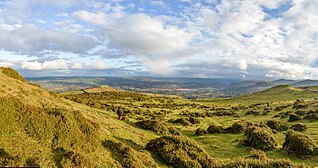
Dartmoor is an upland area in southern Devon, England. The moorland and surrounding land has been protected by National Park status since 1951. Dartmoor National Park covers 954 km2 (368 sq mi).

Stonehenge is a prehistoric monument on Salisbury Plain in Wiltshire, England, two miles (3 km) west of Amesbury. It consists of an outer ring of vertical sarsen standing stones, each around 13 feet (4.0 m) high, seven feet (2.1 m) wide, and weighing around 25 tons, topped by connecting horizontal lintel stones. Inside is a ring of smaller bluestones. Inside these are free-standing trilithons, two bulkier vertical sarsens joined by one lintel. The whole monument, now ruinous, is aligned towards the sunrise on the summer solstice. The stones are set within earthworks in the middle of the densest complex of Neolithic and Bronze Age monuments in England, including several hundred tumuli.
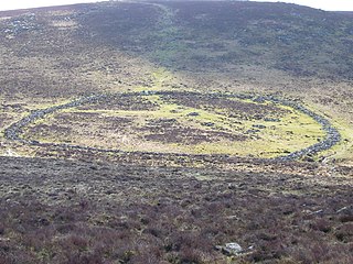
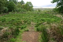
Grimspound is a late Bronze Age settlement, situated on Dartmoor in Devon, England. It consists of a set of 24 hut circles surrounded by a low stone wall. The name was first recorded by the Reverend Richard Polwhele in 1797; it was probably derived from the Anglo-Saxon god of war, Grim.
Navan Fort is an ancient ceremonial monument near Armagh, Northern Ireland. According to tradition it was one of the great royal sites of pre-Christian Gaelic Ireland and the capital of the Ulaidh. It is a large circular hilltop enclosure—marked by a bank and ditch—inside which is a circular mound and the remains of a ring barrow. Archeological investigations show that there were once buildings on the site, including a huge roundhouse-like structure that has been likened to a temple. In a ritual act, this timber structure was filled with stones, deliberately burnt down and then covered with earth to create the mound which stands today. It is believed that Navan was a pagan ceremonial site and was regarded as a sacred space. It features prominently in Irish mythology, especially in the tales of the Ulster Cycle. According to the Oxford Dictionary of Celtic Mythology, "the [Eamhain Mhacha] of myth and legend is a far grander and mysterious place than archeological excavation supports".

A roundhouse is a type of house with a circular plan, usually with a conical roof. In the later part of the 20th century, modern designs of roundhouse eco-buildings were constructed with materials such as cob, cordwood or straw bale walls and reciprocal frame green roofs.

The Holyhead Mountain Hut Circles, also known as 'Tŷ Mawr Hut Circles', Cytiau'r Gwyddelod or the 'Irishmen's Huts', are the remains of a group of Celtic Iron Age huts near Trearddur on Holy Island, Anglesey, Wales. The site is under the care of Cadw and can be visited all year round. The construction of these huts are very similar to those at Din Lligwy, having thick stone walls.

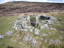
Dartmoor kistvaens are burial tombs or cists from the late Neolithic and early Bronze Age, i.e. from c 2500 BC to c 1500 BC. Kistvaens have been found in many places, including Dartmoor, a 954 km2 area of moorland in south Devon, England. The box-like stone tombs were created when the ancient people of the area lived in hut circles. Cists are often to be found in the centre of a cairn circle although some appear solitary which could be the result of the loss of an original slight mound. There are over 180 known cists on Dartmoor although there could be up to 100 that remain buried underneath unexplored cairns. In the South West there are no cists to be found on the Quantock Hills, only 2 to be found on Exmoor and 58 to be found on Bodmin Moor. The Dartmoor cists are unique in that about 94% have the longer axis of the tomb orientated in a NW/SE direction It appears that Dartmoor cists were positioned in such a way that the deceased were facing the sun.

Moel y Gaer is an Iron Age hillfort located on a summit at the southern end of Halkyn Mountain, overlooking the village of Rhosesmor, Flintshire, Wales. It is a well-preserved hillfort overlooking the Dee Estuary. Excavations in the early 1970s revealed a sequence of defensive structures made of timber and several phases of building work inside the ramparts.
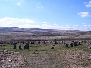
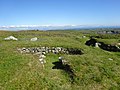
ScorhillStone Circle is now the commonly known name for Gidleigh Stone Circle or Steep Hill Stone Circle, one of Devon's biggest and most intact stone circles, situated on Gidleigh Common near the village of Gidleigh in the north east of Dartmoor, in the United Kingdom. It is an English Heritage scheduled monument and has been described as Devon's finest stone circle.

Bodrifty is the modern name of an Iron Age village, now in ruins, in Cornwall, England, United Kingdom. It is 700 yards west of Mulfra Hill in Penwith District, 3 miles northwest of Penzance and 1.5 miles southwest of Porthmeor, on the high ground of the watershed between the Atlantic and the English Channel. Today the settlement is barely more than a farm within the boundary of the village of New Mill, just north of Boskednan.

Dunbeg Fort is a promontory fort built in the Iron Age near the modern village of Ventry in County Kerry, Ireland.

The stone circles in the British Isles and Brittany are a megalithic tradition of monuments consisting of standing stones arranged in rings. These were constructed from 3300 to 900 BCE in Britain, Ireland and Brittany. It has been estimated that around 4,000 of these monuments were originally constructed in this part of north-western Europe during this period. Around 1,300 of them are recorded, the others having been destroyed.

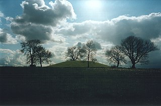
The architecture of Scotland in the prehistoric era includes all human building within the modern borders of Scotland, before the arrival of the Romans in Britain in the first century BCE. Stone Age settlers began to build in wood in what is now Scotland from at least 8,000 years ago. The first permanent houses of stone were constructed around 6,000 years ago, as at Knap of Howar, Orkney and settlements like Skara Brae. There are also large numbers of chambered tombs and cairns from this era, particularly in the west and north. In the south and east there are earthen barrows, often linked to timber monuments of which only remnants remain. Related structures include bank barrows, cursus monuments, mortuary enclosures and timber halls. From the Bronze Age there are fewer new buildings, but there is evidence of crannogs, roundhouses built on artificial islands and of Clava cairns and the first hillforts. From the Iron Age there is evidence of substantial stone Atlantic roundhouses, which include broch towers, smaller duns. There is also evidence of about 1,000 hillforts in Scotland, most located below the Clyde-Forth line.

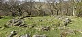
Cosdon Hill, also called Cosdon Beacon, or Cawsand Beacon, is one of the highest hills on Dartmoor, in Devon, England. It has numerous traces of prehistoric occupation.

Porlock Stone Circle is a stone circle located on Exmoor, near the village of Porlock in the south-western English county of Somerset. The Porlock ring is part of a tradition of stone circle construction that spread throughout much of Britain, Ireland, and Brittany during the Late Neolithic and Early Bronze Age, over a period between 3300 and 900 BCE. The purpose of such monuments is unknown, although archaeologists speculate that the stones represented supernatural entities for the circles' builders.

Withypool Stone Circle, also known as Withypool Hill Stone Circle, is a stone circle located on the Exmoor moorland, near the village of Withypool in the southwestern English county of Somerset. The ring is part of a tradition of stone circle construction that spread throughout much of Britain, Ireland, and Brittany during the Late Neolithic and Early Bronze Age, over a period between 3300 and 900 BCE. The purpose of such monuments is unknown, although archaeologists speculate that the stones represented supernatural entities for the circle's builders.

Bryn Eryr is an archaeological site near Llansadwrn, Anglesey, Wales, where the remains of an Iron Age farmstead, consisting of three roundhouses, have been excavated. Excavations took place in the period between 1985 and 1987, and were carried out by the Gwynedd Archaeological Trust.
Caer Bach is a Welsh hillfort of indeterminate age, on a rounded hillock situated near the village of Rowen; in Conwy County, North Wales. Its name in English translates as 'Small Fort'; or alternatively 'Little Fortress'. It is situated on the Eastern slopes of Tal-y-Fan, an outlying peak of the Carneddau mountain range in northeast Snowdonia; at an altitude of approximately 413 metres. Little information is known about the history of the fort, as to date, the site has undergone minimal investigation. The fort is classed as a scheduled ancient monument and is of national importance for its potential to enhance our knowledge of prehistoric settlement. It is said to retain significant archaeological potential, with a strong probability of the presence of associated archaeological features and deposits.

Castell Caer Seion is an Iron Age hillfort situated at the top of Conwy Mountain, in Conwy County, North Wales. It is unusual for the fact that the main fort contains a smaller, more heavily defended fort, complete with its own distinct defences and entrance, with no obvious means of access between the two. The construction date of the original fort is still unknown, but recent excavations have revealed evidence of occupation as early as the 6th century BC, whilst the smaller fort can be dated with reasonable certainty to around the 4th century BC. Whilst the forts were constructed in different periods, archaeologists have uncovered evidence of concurrent occupation, seemingly up until around the 2nd century BC. The larger fort contained around 50 roundhouses during its lifetime, whereas examinations of the smaller fort have turned up no more than six. The site was traditionally associated with Maelgwyn Gwynedd, but there is no evidence pointing to a 6th-century occupation. The fort and wider area beyond its boundaries have been said to retain significant archaeological potential, and are protected by law as a scheduled ancient monument.