Nijmegen is the largest city in the Dutch province of Gelderland and the tenth largest of the Netherlands as a whole. Located on the Waal River close to the German border, Nijmegen is one of the oldest cities in the Netherlands and the first to be recognized as such in Roman times. In 2005, it celebrated 2,000 years of existence.

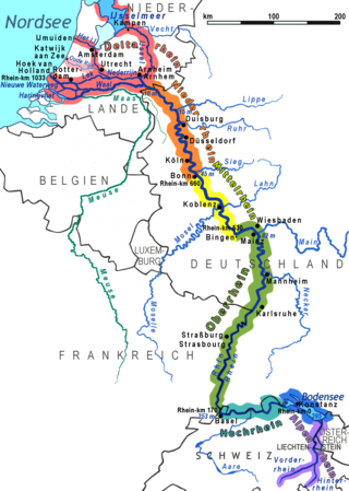
The Rhine is one of the major European rivers. The river begins in the Swiss canton of Graubünden in the southeastern Swiss Alps. It forms part of the Swiss-Liechtenstein, Swiss-Austrian, and Swiss-German borders. After that the Rhine defines much of the Franco-German border, after which it flows in a mostly northerly direction through the German Rhineland. Finally in Germany, the Rhine turns into a predominantly westerly direction and flows into the Netherlands where it eventually empties into the North Sea. It drains an area of 9,973 km2 and its name derives from the Celtic Rēnos. There are also two German states named after the river, North Rhine-Westphalia and Rhineland-Palatinate.

The Waal is the main distributary branch of the river Rhine flowing approximately 80 km (50 mi) through the Netherlands. It is the major waterway connecting the port of Rotterdam to Germany. Before it reaches Rotterdam, it joins with the Afgedamde Maas near Woudrichem to form the Boven Merwede. Along its length, Nijmegen, Tiel, Zaltbommel and Gorinchem are towns of importance with direct access to the river.

The IJssel is a Dutch distributary of the river Rhine that flows northward and ultimately discharges into the IJsselmeer, a North Sea natural harbour. It more immediately flows into the east-south channel around the Flevopolder, Flevoland which is kept at 3 metres below sea level. This body of water is then pumped up into the IJsselmeer.
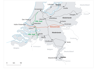
The Betuweroute is a double track freight railway between Rotterdam and Germany. Betuweroute is the official name, after the Betuwe area through which the route passes. The line is popularly called Betuwelijn, after an older local rail line in the same region. The line extends into Germany as the Oberhausen–Arnhem railway, and it is part of Project No. 5 of the Trans-European Transport Network (TEN-T).
The Netherlands entered World War II on May 10, 1940, when invading German forces quickly overran the country. On December 7, 1941, after the attack on Pearl Harbor, the Netherlands government in exile also declared war on Japan. Operation Market Garden, which started in 1944, liberated the southern and eastern parts of the country, but full liberation did not come until the surrender of Germany on May 5, 1945.
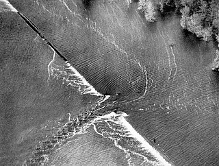
A levee breach or levee failure is a situation where a levee fails or is intentionally breached, causing the previously contained water to flood the land behind the levee.

The Dutch Waterline was a series of water-based defences conceived by Maurice of Nassau in the early 17th century, and realised by his half brother Frederick Henry. Combined with natural bodies of water, the Waterline could be used to transform Holland, the westernmost region of the Netherlands and adjacent to the North Sea, almost into an island. In the 19th century, the Line was extended to include Utrecht.

Operation Veritable was the northern part of an Allied pincer movement that took place between 8 February and 11 March 1945 during the final stages of the Second World War. The operation was conducted by Field Marshal Bernard Montgomery's Anglo-Canadian 21st Army Group, primarily consisting of the First Canadian Army under Lieutenant-General Harry Crerar and the British XXX Corps under Lieutenant-general Brian Horrocks.

The German invasion of the Netherlands, otherwise known as the Battle of the Netherlands, was a military campaign part of Case Yellow, the Nazi German invasion of the Low Countries and France during World War II. The battle lasted from 10 May 1940 until the surrender of the main Dutch forces on 14 May. Dutch troops in the province of Zealand continued to resist the Wehrmacht until 17 May, when Germany completed its occupation of the whole country.
The Lower Rhine flows from Bonn, Germany, to the North Sea at Hook of Holland, Netherlands ; alternatively, Lower Rhine may refer to the part upstream of Pannerdens Kop, excluding the Nederrijn.

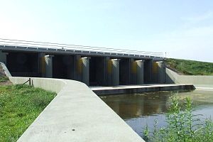
Flood control is an important issue for the Netherlands, as due to its low elevation, approximately two thirds of its area is vulnerable to flooding, while the country is densely populated. Natural sand dunes and constructed dikes, dams, and floodgates provide defense against storm surges from the sea. River dikes prevent flooding from water flowing into the country by the major rivers Rhine and Meuse, while a complicated system of drainage ditches, canals, and pumping stations keep the low-lying parts dry for habitation and agriculture. Water control boards are the independent local government bodies responsible for maintaining this system.

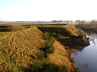
The Grebbe Line was a forward defence line of the Dutch Water Line, based on inundation. The Grebbe Line ran from the Grebbeberg in Rhenen northwards until the IJsselmeer.
In the Netherlands, a water board, water council or water authority is a regional governing body solely charged with the management of surface water in the environment. Water boards are independent of administrative governing bodies like provinces and municipalities. In general, they are responsible for managing rivers and canals, issues with the flow of watercourses and drainage issues, water collection, flood and erosion prevention and provision of potable water. They manage polder systems, water levels, water barriers and locks, enforcements, water quality and sewage treatment in their respective regions. The concept of a coordinating "High Water Authority" (Hoogheemraadschap) originated in what now is the province of South Holland in the 12th century.
In the Netherlands, Room for the River is a government design plan intended to address flood protection, master landscaping and the improvement of environmental conditions in the areas surrounding the Netherlands' rivers. The project was active from 2006–2015.

The Rhine–Meuse–Scheldt delta is a river delta in the Netherlands formed by the confluence of the Rhine, the Meuse and the Scheldt rivers. In some cases, the Scheldt delta is considered a separate delta to the Rhine–Meuse delta. The result is a multitude of islands, branches and branch names, in which a waterway that appears to be one continuous stream may have numerous separate names for different sections, e.g. Rhine → Bijlands Kanaal → Pannerdens Kanaal → Nederrijn → Lek → Nieuwe Maas → Het Scheur → Nieuwe Waterweg. Since the Rhine contributes most of the water, the term "Rhine Delta" is commonly used, although this name is also used for the delta where the Alpine Rhine flows into Lake Constance. By some calculations, the Rhine–Meuse–Scheldt delta covers 25,347 km2 (9,787 sq mi), making it the largest in Europe.

The Peel-Raam Line was a Dutch defence line built in 1939 and attacked and conquered on 10 May 1940 by the German forces.
The Frisian waterline started being built around 1580. The defence line goes from the Zuidersea, along the River Linde, to the De Blesse Bridge. Then, the defence line goes northward to Kuinre by way of Heerenveen, Terband, Gorredijk, Donkerbroek, Bakkeveen and Frieschepalen.

The West Brabant waterline is a Dutch military defense line based on inundation.