| Imeong Conservation Area | |
|---|---|
 | |
| Location | Palau |
| Area | 1,250 ha (4.8 sq mi) |
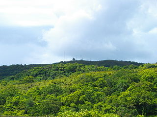
The Imeong Conservation Area is an area of roughly 1,250 sq m located in western Palau.
| Imeong Conservation Area | |
|---|---|
| | |
| Location | Palau |
| Area | 1,250 ha (4.8 sq mi) |
The Imeong Conservation Area is an area of roughly 1,250 sq m located in western Palau.
The area includes multiple ecosystems types including rain forest, savanna, and mangrove wetlands. [1] It also contains the island's highest points that create important drainage systems for the western part of the island. [1] Not solely proposed to protect the natural wonders of the area, the Imeong Conservation will also strive to protect the important surrounding cultural sites. These sites include the Ii ra Milad sacred rock shelter, which is widely known as the most sacred site in all of Palau, and the Ngerutechei traditional Palauan village. [1]
This site was added to the UNESCO World Heritage Tentative List on August 26, 2004 in the Mixed (Cultural + Natural) category. [1]

Palau, officially the Republic of Palau, is an island country in the Micronesia subregion of Oceania in the western Pacific. The republic consists of approximately 340 islands and connects the western chain of the Caroline Islands with parts of the Federated States of Micronesia. It has a total area of 466 square kilometers (180 sq mi), making it one of the smallest countries in the world. The most populous island is Koror, home to the country's most populous city of the same name. The capital Ngerulmud is located on the largest island of Babeldaob, in Melekeok State. Palau shares maritime boundaries with international waters to the north, the Federated States of Micronesia to the east, Indonesia to the south, and the Philippines to the northwest.
A World Heritage Site is a landmark or area with legal protection by an international convention administered by the United Nations Educational, Scientific and Cultural Organization (UNESCO). World Heritage Sites are designated by UNESCO for having cultural, historical, scientific or other forms of significance. The sites are judged to contain "cultural and natural heritage around the world considered to be of outstanding value to humanity".
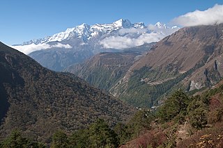
Sagarmāthā National Park is a national park in the Himalayas of eastern Nepal that is dominated by Mount Everest. It was established as a National Park in 1976. It encompasses an area of 1,148 km2 (443 sq mi) in the Solukhumbu District and ranges in elevation from 2,845 to 8,848 m at the summit of Mount Everest. In the north, it shares the international border with Qomolangma National Nature Preserve in Tibet Autonomous Region. In the east, it is adjacent to Makalu Barun National Park, and in the south it extends to Dudh Kosi river. It is part of the Sacred Himalayan Landscape.

Cultural landscape is a term used in the fields of geography, ecology, and heritage studies, to describe a symbiosis of human activity and environment. As defined by the World Heritage Committee, it is the "cultural properties [that] represent the combined works of nature and of man" and falls into three main categories:

Protected areas of New Zealand are areas that are in some way protected to preserve their environmental, scientific, scenic, historical, cultural or recreational value. There are about 10,000 protected areas, covering about a third of the country. The method and aims of protection vary according to the importance of the resource and whether it is publicly or privately owned.

Ngiwal is one of the sixteen states of Palau. It has a population of 282 and an area of 26 km2
Ngeremlengui is one of Palau's sixteen states. It has a population of 349, and is just west of the capital in Melekeok state. Among the 16 states of Palau, it’s the one with the lowest density but the one with the most neighbor states. It’s also the seventh most populous state.
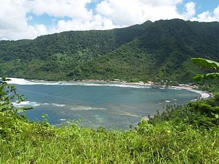
The Fagaloa Bay – Uafato Tiavea Conservation Zone is located in the Va'a-o-Fonoti District of Samoa, on eastern Upolu Island.
A sacred natural site is a natural feature or a large area of land or water having special spiritual significance to peoples and communities. Sacred natural sites consist of all types of natural features including mountains, hills, forests, groves, trees, rivers, lakes, lagoons, caves, islands and springs. They are often considered sacred spaces.
Biosphere reserves are areas comprising terrestrial, marine and coastal ecosystems. The biosphere reserve title is handed over by UNESCO. Each reserve promotes solutions reconciling the conservation of biodiversity with its sustainable use. Biosphere reserves are 'Science for Sustainability support sites' – special places for testing interdisciplinary approaches to understanding and managing changes and interactions between social and ecological systems, including conflict prevention and management of biodiversity. Biosphere reserves are nominated by national governments and remain under the sovereign jurisdiction of the states where they are located. Their status is internationally recognized.

Getbol (Korean: 갯벌) are mudflats, or tidal flats, coastal sedimentary systems. They are important habitats for different types of organisms, including migrating birds and marine fauna such as clams, crabs, octopuses, and snails. In 2021, four getbol sites in South Korea were listed as a UNESCO World Heritage Site due to their outstanding natural properties. Each of these sites represent a different type of getbol.
Imeong Conservation Area – UNESCO World Heritage Centre Retrieved 2009-03-03.