Related Research Articles

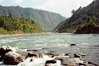
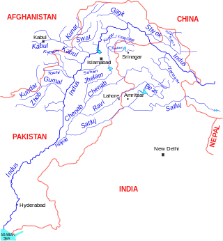
The IndusIN-dəs is a transboundary river of Asia and a trans-Himalayan river of South and Central Asia. The 3,120 km (1,940 mi) river rises in mountain springs northeast of Mount Kailash in Western Tibet, flows northwest through the disputed region of Kashmir, bends sharply to the left after the Nanga Parbat massif, and flows south-by-southwest through Pakistan, before emptying into the Arabian Sea near the port city of Karachi.

Punjab is a geopolitical, cultural, and historical region in South Asia, specifically in the northern part of the Indian subcontinent, on the Indus Plain comprising areas of eastern Pakistan and northwestern India. Punjab's major cities are Lahore, Faisalabad, Rawalpindi, Gujranwala, Multan, Ludhiana, Amritsar, Sialkot, Chandigarh, Shimla, Jalandhar, Gurugram, and Bahawalpur.

Punjab is a province of Pakistan. Located in central-eastern region of the country, Punjab is the second-largest province of Pakistan by land area and the largest province by population. It is bordered by the Pakistani provinces of Khyber Pakhtunkhwa to the north-west, Balochistan to the south-west and Sindh to the south, as well as Islamabad Capital Territory to the north-west and Autonomous state of AJK to the north. It shares an International border with the Indian states of Rajasthan and Punjab to the east and Indian-administered Kashmir to the north-east. Punjab is the most fertile province of the country as River Indus and its four major tributaries Ravi, Jhelum, Chenab and Sutlej flow through it.

Sindh is a province of Pakistan. Located in the southeastern region of the country, Sindh is the third-largest province of Pakistan by land area and the second-largest province by population after Punjab. It is bordered by the Pakistani provinces of Balochistan to the west and north-west and Punjab to the north. It shares an International border with the Indian states of Gujarat and Rajasthan to the east; it is also bounded by the Arabian Sea to the south. Sindh's landscape consists mostly of alluvial plains flanking the Indus River, the Thar Desert in the eastern portion of the province along the international border with India, and the Kirthar Mountains in the western portion of the province.

Bahawalpur was a princely state of British India, and later Dominion of Pakistan, that was a part of the Punjab States Agency. It existed as an autonomous state, within Pakistan from 1947 to 1955, when it was dissolved and merged into the West Pakistani Province. The state covered an area of 45,911 km2 (17,726 sq mi) and had a population of 1,341,209 in 1941. The capital of the state was the town of Bahawalpur.

The Beas River is a river in north India. The river rises in the Himalayas in central Himachal Pradesh, India, and flows for some 470 kilometres (290 mi) to the Sutlej River in the Indian state of Punjab. Its total length is 470 kilometres (290 mi) and its drainage basin is 20,303 square kilometres (7,839 sq mi) large.

The History of Punjab refers to the past human history of Punjab region which is a geopolitical, cultural, and historical region in the northwest of the Indian subcontinent, comprising western Punjab province in Pakistan and eastern Punjab state in India. It is believed that the earliest evidence of human habitation in Punjab traces to the Soan valley of the Pothohar, between the Indus and the Jhelum rivers, where Soanian culture developed between 774,000 BC and 11,700 BC. This period goes back to the first interglacial period in the second Ice Age, from which remnants of stone and flint tools have been found.
The Punjabis, are an Indo-Aryan ethnolinguistic group associated with the Punjab region of the Indian subcontinent, comprising areas of eastern Pakistan and northwestern India. They generally speak Standard Punjabi or various Punjabi dialects on both sides.
The Ravi River is a transboundary river crossing northwestern India and eastern Pakistan. It is one of five rivers associated with the Punjab region.

The Chenab River is a major river that flows in India and Pakistan, and is one of the 5 major rivers of the Punjab region. It is formed by the union of two headwaters, Chandra and Bhaga, which rise in the upper Himalayas in the Lahaul region of Himachal Pradesh, India. The Chenab flows through the Jammu region of Jammu and Kashmir, India into the plains of Punjab, Pakistan, before ultimately flowing into the Indus River.
The Indus Water Treaty (IWT) is a water-distribution treaty between India and Pakistan, arranged and negotiated by the World Bank, to use the water available in the Indus River and its tributaries. It was signed in Karachi on 19 September 1960 by then Indian Prime Minister Jawaharlal Nehru and then Pakistani president Ayub Khan.
The history of Sindh refers to the history of the modern-day Pakistani province of Sindh, as well as neighboring regions that periodically came under its sway.
Farakka Barrage is a barrage across the Ganga river located in Murshidabad district in the Indian state of West Bengal, roughly 18 kilometres (11 mi) from the border with Bangladesh near Shibganj. Farakka Barrage Township is located in Farakka in Murshidabad district. Construction of the Farakka barrage started in 1962, was completed in 1970 at a cost of $208 million. Operations began on 21 April 1975. The barrage is about 2,304 metres (7,559 ft) long. The Feeder Canal (Farakka) from the barrage to the Bhagirathi-Hooghly River is about 42 km (26 mi) long.
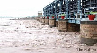
Marala Headworks is a headworks situated on the Chenab River near the city of Sialkot in Punjab, Pakistan. A weir was first built during 1906–1912 in British India to feed the Upper Chenab Canal, as part of the 'Triple Canals Project'. A new Marala Barrage was constructed in 1968 to feed the Marala–Ravi Link Canal in addition to the original Upper Chenab Canal.

Water conflict is a term describing a conflict between countries, states, or groups over the rights to access water resources. The United Nations recognizes that water disputes result from opposing interests of water users, public or private. A wide range of water conflicts appear throughout history, though rarely are traditional wars waged over water alone. Instead, water has long been a source of tension and one of the causes for conflicts. Water conflicts arise for several reasons, including territorial disputes, a fight for resources, and strategic advantage.

Feeder Canal is a canal associated with Farakka Barrage. It is located in Murshidabad district, West Bengal. The canal is 38.3 km(26 miles) long. The Ganges water from the Farakka Dam is being conveyed to Bhagirathi by way of this canal. Due to the flow of river Bhagirathi-Hooghly through the Farakka dam project, around 40,000 cusec of water is available daily in the Feeder connection. The Feeder canal has been designed keeping in mind the ability to carry this amount of water. However, during the dry season, less water is released. The dry season is from January to May. During the period the flow of water in the feeder canal is reduced from 40 thousand cusecs to 30 to 28 thousand cusecs. If the severe drought brings down the Ganges water from its upper reaches, then less water is available in feeder canal.
Madhopur Headworks is a barrage on the Ravi River, just 14km from Pathankot city in Pathankot district in the Indian state of Punjab. It is located on the border with Jammu and Kashmir. The Upper Bari Doab Canal (UBDC) off-taking from Madhopur irrigates agricultural lands in Punjab and provides water to the cities of Pathankot, Gurdaspur, Batala and Amritsar.

The Barsoi–New Farakka section is an Indian railway line connecting Barsoi with New Farakka junction on the Howrah–New Jalpaiguri line. This 126-kilometre (78 mi) track is under the jurisdiction of Eastern Railway and Northeast Frontier Railway.

Head Balloki or Balloki Headworks is a barrage on the Ravi River in the Punjab, Pakistan.it is 70 KM distance from Lahore. It was first built around in 1915 in British India as part of the 'Triple Canals Project' to feed the Lower Bari Doab Canal. The canal turned in a profit of 24% within ten years. The original weir has now been rebuilt as a full barrage.
Bedian, also spelled Badian, is a village in the Kasur District of Punjab, Pakistan, close to the India-Pakistan border. The village was founded by the Sikh preacher Baba Sahib Singh Bedi during the region of Maharaja Ranjit Singh. After the partition of India, Pakistan built the Bambawali-Ravi-Bedian Canal, bringing waters from the Chenab River to the Upper Bari Doab Canal, as a replacement for the canal waters lost to the Indian Punjab.
References
- ↑ Salman & Uprety, Conflict and Cooperation (2002), pp. 42–43.
- ↑ Salman & Uprety, Conflict and Cooperation (2002), pp. 43–44.
- ↑ Gilmartin, Blood and Water (2020), pp. 210–211.
- ↑ Gilmartin, Blood and Water (2020) , p. 211: 'The stoppage of canal water, perhaps more than any other single event in the first year of Pakistan’s existence, gave Radcliffe’s artificial line simultaneous "natural" and "national" meaning'.