
Reading is a town and borough in Berkshire, England. Most of its built-up area lies within the Borough of Reading, although some outer suburbs are parts of neighbouring local authority areas. Located in the Thames Valley at the confluence of the rivers Thames and Kennet, Reading is 40 miles (64 km) east of Swindon, 25 miles (40 km) south of Oxford, 40 miles (64 km) west of London and 16 miles (26 km) north of Basingstoke.

Slough is a town in Berkshire, England, in the Thames Valley 20 miles (32 km) west of central London and 19 miles (31 km) north-east of Reading, at the intersection of the M4, M40 and M25 motorways. It is part of the historic county of Buckinghamshire. In 2021 Census, the population of the town was 143,184. In 2021, the wider Borough of Slough had a population of 158,500. Slough borders the ceremonial counties of Greater London and Buckinghamshire.

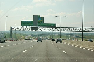
The M4, originally the London-South Wales Motorway, is a motorway in the United Kingdom running from west London to southwest Wales. The English section to the Severn Bridge was constructed between 1961 and 1971; the Welsh element was largely complete by 1980, though a non-motorway section around Briton Ferry bridge remained until 1993. On the opening of the Second Severn Crossing in 1996, the M4 was rerouted over it.

Medway is borough and unitary authority area in Kent, South East England. It had a population of 278,016 in 2019. The unitary authority was formed in 1998, when the boroughs of Rochester-upon-Medway and Gillingham were merged to form Medway Towns. The borough is governed by Medway Council, a unitary authority which is independent of Kent County Council, but remains part of the ceremonial county of Kent.

The Westway is a 2.5-mile (4 km) elevated dual carriageway section of the A40 trunk road in West London running from Paddington in the east to North Kensington in the west. It connects the London Inner Ring Road to the West London suburbs.
The A2 is a major road in south-east England, connecting London with the English Channel port of Dover in Kent. This route has always been of importance as a connection between London and sea trade routes to Continental Europe. It was originally known as the Dover Road. The M2 motorway has replaced part of the A2 as the strategic route.

The M8 is the busiest motorway in Scotland. It connects the country's two largest cities, Glasgow and Edinburgh, and serves other large communities including Airdrie, Coatbridge, Greenock, Livingston and Paisley. The motorway is 60 miles (97 km) long. A major construction project to build the final section between Newhouse and Baillieston was completed on 30 April 2017. The motorway has one service station, Heart of Scotland Services, previously named Harthill due to its proximity to the village.

The A33 is a major road in the counties of Berkshire and Hampshire in southern England. The road currently runs in three disjoint sections.

The A417 is a main road in England running from Streatley, Berkshire to Hope under Dinmore, Herefordshire. It is best known for its section between Cirencester and Gloucester where it has primary status and forms part of the link between the major settlements of Swindon and Gloucester.
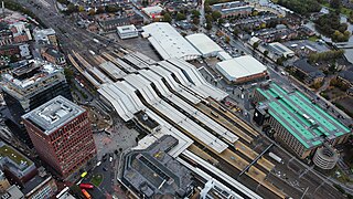
Reading railway station is a major transport hub in Reading, Berkshire, England; it is 36 miles (58 km) west of London Paddington. It is sited on the northern edge of the town centre, near to the main retail and commercial areas and the River Thames. It is the busiest station in Berkshire, and the third busiest in South East England.
Oxford Road is an urban street and major arterial road in Reading, Berkshire, England, Beginning near the town centre at the meeting of St. Mary's Butts/West Street/Broad Street. The road leads west to Pangbourne, continuing eventually to the city of Oxford. The road was previously known as Pangbourne Lane.

The London Ringways were a series of four ring roads planned in the 1960s to circle London at various distances from the city centre. They were part of a comprehensive scheme developed by the Greater London Council (GLC) to alleviate traffic congestion on the city's road system by providing high-speed motorway-standard roads within the capital, linking a series of radial roads taking traffic into and out of the city.

The Peaks Parkway is part of the northern end of the A16 road, in Grimsby, North East Lincolnshire, England. It was conceived in the 1970s and follows part of the trackbed of the former East Lincolnshire Railway between Grimsby and Louth.

The A329 is an east–west road in Southern England that runs from Wentworth in Surrey to Thame in Oxfordshire.

The A4232, which is also known either as the Peripheral Distributor Road (PDR) (Welsh: Ffordd Ddosbarthu Ymylol) or the Cardiff Link Road (Welsh: Ffordd Gyswllt Caerdydd), is a distributor road in Cardiff, the capital of Wales.
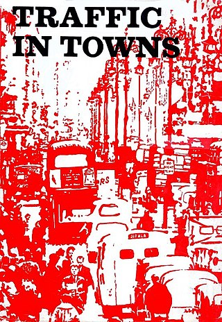
Traffic in Towns is an influential report and popular book on urban and transport planning policy published 25 November 1963 for the UK Ministry of Transport by a team headed by the architect, civil engineer and planner Colin Buchanan. The report warned of the potential damage caused by the motor car, while offering ways to mitigate it. It gave planners a set of policy blueprints to deal with its effects on the urban environment, including traffic containment and segregation, which could be balanced against urban redevelopment, new corridor and distribution roads and precincts.
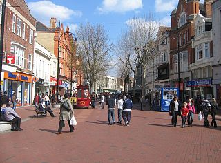
Broad Street is a main pedestrianised thoroughfare and the primary high street in the English town of Reading. The street is situated in the town centre, running for approximately 0.25 miles (0.40 km), from west to east. The western end of the road lies at the crossroads with Oxford Road, West Street and St Mary's Butts. The eastern end continues as King Street after the junction with Minster Street and Butter Market.

Reading's location in the Thames Valley at the confluence of the River Thames and River Kennet, and on both the Great Western Main Line and the M4 motorway, some 40 miles (64 km) west of London has made the town an important location in the nation's transport system.

The Coley branch line (ELR:COY), also known as the Coley goods branch, was a single-track branch railway running 1 mile 61 chains from the Reading to Basingstoke line at Coley Branch Junction to Reading Central goods depot.

Road building was central to planning policy for much of the 20th century in Bristol, England. The planned road network evolved over time but at its core was a network of concentric ring roads and high-capacity radial roads.

