Interstate 84 (Oregon–Utah)

Last updated

I-84.svg

Interstate 84

Interstate 84 (Oregon-Utah)
I-84 highlighted in red
Route information
Length769.62 mi [1]  (1,238.58 km)
Existed1956 (as I-80N)–present
NHSEntire route
Major junctions
West endI-5.svgUS 30.svg I-5  / US 30 in Portland, OR
Major intersections
East endI-80.svgUS 189.svg I-80  / US 189 in Echo, UT
Location
Country United States
States Oregon, Idaho, Utah
Highway system

Interstate 84 (I-84) is an Interstate Highway in the northwestern United States. The highway runs from Portland, Oregon, to a junction with I-80 near Echo, Utah. The highway serves and connects Portland, Boise, and Ogden, Utah. With connections to other highways, I-84 connects these cities to points east and also serves as part of a corridor between Seattle and Salt Lake City. The sections running through Oregon and Idaho are also known as the Vietnam Veterans Memorial Highway. [2] [3]

Contents

The highway originally served as a fork of I-80 to serve the Pacific Northwest, and was originally numbered Interstate 80N. It was generally built along the corridor of U.S. Route 30 (US 30) and US 30S, which themselves largely followed the Oregon Trail; the US 30S designation was decommissioned in the 1970s after the freeway replacement was mostly complete. The highway was signed with the I-84 designation in 1980, when a 1977 change in guidelines took effect that discouraged highway numbers with directional suffixes. [4] The renumbering resulted in two highways being numbered I-84, with the other located in the Northeastern United States.

Route description

Lengths
  mi [1] km
OR 379610
ID 275.74443.76
UT 118.71191.05
Total769.621,238.58

Oregon

The western terminus of I-84 in Portland I-84 and I-5 interchange.jpg
The western terminus of I-84 in Portland

In the Portland metropolitan area, I-84 is sometimes referred to as the "Banfield Freeway" or simply "the Banfield", although the official name is the Banfield Expressway. This freeway is named after Thomas H. "Harry" Banfield (1885–1950), the chairman of the Oregon Transportation Commission from 1943 to 1950. As I-84 heads east, it also follows US 30 in a majority of I-84 from Portland, Oregon, to near Rupert, Idaho, with splits being variant in Oregon and Idaho, but before leaving Portland, there is a junction with I-205, along with cities Gresham, Fairview, Wood Village and Troutdale.

Columbia River Gorge and I-84 as seen from Crown Point, Oregon I-84 ColumbiaR.jpg
Columbia River Gorge and I-84 as seen from Crown Point, Oregon

Immediately after leaving Troutdale, I-84 and US 30 runs east along the south bank of the Columbia River (and the northern Oregon border, as well) for nearly 150 miles (240 km) with the first 80 miles being in the Columbia River Gorge National Scenic Area, running from Troutdale to the Deschutes River, passing through the cities of Hood River and The Dalles in the Scenic Area. It also passes through Biggs Junction, Rufus, Arlington, and Boardman outside of the Scenic Area before heading southeast to the junction with southern end of I-82 immediately southeast of the Umatilla Chemical Depot near Hermiston. From the junction it continues southeast on to Pendleton.

East of Pendleton, I-84 climbs Emigrant Hill, a 6% grade, into the Blue Mountains. The westbound lanes switchback twice on its descent into Pendleton. Eastbound lanes feature the tightest curves allowed on the Interstate Highway system, even though those curves are on the uphill (eastbound) direction. This grade is also well known because of the distance between eastbound and westbound lanes, nearly 2 miles (3.2 km) between the opposite directions of travel at some points.

The road summits at 4,193 feet (1,278 m) above sea level before descending to the Grand Ronde River and La Grande. It passes by North Powder and Baker City and through the Burnt River canyon. Around Huntington, it crosses into the Mountain Time Zone then briefly follows the southwest bank of the Snake River (Brownlee Reservoir), then continues to Ontario before crossing the Snake River into Idaho.

On March 1, 2016, the speed limit from The Dalles to Ontario was raised to 70 miles per hour (110 km/h), while the truck speed was raised to 65 miles per hour (105 km/h). [5]

Idaho

I-84 enters Idaho by crossing the Snake River at Ontario, Oregon. From there, it continues on to the major cities of the Treasure Valley (or Boise metropolitan area) including Caldwell, Nampa, Meridian, and Boise (where I-184 connects travelers to downtown). From Boise, I-84 continues southeast passing near several small cities (Mountain Home, Glenns Ferry, and Jerome) on its way to Twin Falls.

Just east of Jerome, I-84 passes within five miles (8.0 km) of Twin Falls, but does not cross the Snake River Canyon or into Twin Falls County. Access to Twin Falls is afforded by an intersection with US 93 at Exit 173; US 93 southbound crosses the Snake River via the Perrine Bridge.

After Twin Falls, I-84 continues through Burley and Heyburn. Approximately seven miles (11 km) east of Declo in rural Cassia County, I-84 meets the western terminus of the western section of I-86. While I-86, along with US 30 heads east, then northeast to American Falls and Pocatello (following the Oregon Trail), I-84 heads southeast to the border with Utah.

In 2014, the speed limit on rural sections of I-84 in Idaho was raised to 80 miles per hour (130 km/h). [6]

Utah

From Idaho, I-84 enters Utah at a point approximately 7 miles (11.3 km) from Snowville in Box Elder County. It proceeds southeast through Rattle Snake Pass towards Brigham City where I-84 joins I-15 (just west of Tremonton) for its next 40 miles (64 km).

The eastern terminus of I-84 in Echo, Utah I-84atEcho.jpg
The eastern terminus of I-84 in Echo, Utah

Just north of Brigham City, at Corinne, Utah, I-84 joins the route of the First transcontinental railroad which the highway follows to its terminus. I-15/I-84 heads south to the cities of the Wasatch Front (Or the Ogden-Clearfield Utah Metropolitan part) passing through several smaller communities and then the west side of Ogden before I-84 separates towards Cheyenne, Wyoming, while I-15 heads to Salt Lake City, I-84 follows the Weber River east.

As the freeway gradually ascends through Weber Canyon it also passes through several small farming communities, including Morgan, where the Browning Arms Company headquarters can be seen from the freeway. Also visible in the canyon is Devil's Slide, an unusual rock formation just off the freeway. [7] Farther up the canyon is the Thousand Mile Tree, planted by Union Pacific Railroad workers to mark 1,000 miles (1,600 km) from the railroad's origin in Omaha, Nebraska. [8]

The freeway ends at Echo, a near ghost town that before served as a stopover for the railroad, at a junction with Interstate 80, to Cheyenne, Wyoming, and US 189, to Jackson, Wyoming. Also near the junction are Echo Reservoir and Echo Dam.

The Utah sections of I-84 that are not concurrent with Interstate 15 are defined at Utah Code Annotated § 72-4-114(4). [9]

History

I-84's previous shield, as seen in Corbett, Oregon (May 1973). OVERLOOKING THE COLUMBIA RIVER AT CORBETT, NEAR THE CASCADE LOCKS ON THE LEWIS AND CLARK TRAIL - NARA - 548140.jpg
I-84's previous shield, as seen in Corbett, Oregon (May 1973).

The Portland to Utah corridor was proposed as one of the national "toll superhighways" in a 1939 report by the Bureau of Public Roads. [10] It was formally included in the Interstate Highway System, created in 1956, and was originally proposed to be numbered as Interstate 82; [11] however, it was never signed with this designation, and the Interstate 82 designation was later assigned to a different road that connects Ellensburg, Washington, to Yakima, Washington, the Tri-Cities region, and Hermiston, Oregon. The freeway was assigned the designation of I-80N in the 1958 plan, in part to correspond with US 30. [12] [13] The Portland segment of then-I-80N was proposed to run on the Mount Hood Freeway and a section of I-205. [14] [15] Plans for this were officially dropped in 1974 after a successful freeway revolt. [16]

The American Association of State Highway and Transportation Officials established guidelines recommending that "suffixed" highways, such as I-80N, be renumbered. In 1977, Idaho officials recommended that I-80N be renumbered to I-84. The motion was seconded by officials in Utah (who initially proposed this as I-82), but opposed by Oregon and Washington. The motion passed on July 7, 1977, and the states were given until July 1, 1980, to implement a coordinated renumbering strategy. [4] After renumbering, I-84 violated the Interstate Highway Numbering Convention by being south of the modern incarnation of I-82. [17]

Major intersections

Oregon
Idaho
Utah

[18]

Auxiliary routes

See also

Related Research Articles

<span class="mw-page-title-main">Interstate 15</span> Interstate in the Western United States

Interstate 15 (I-15) is a major Interstate Highway in the Western United States, running through Southern California and the Intermountain West. I-15 begins near the Mexican border in San Diego County and stretches north to Alberta, Canada, passing through the states of California, Nevada, Arizona, Utah, Idaho, and Montana. The Interstate serves the cities of San Diego, San Bernardino, Las Vegas, Salt Lake City, Idaho Falls, and Great Falls. It also passes close to the urban areas of Los Angeles, Orange, and Riverside counties, California. The stretches of I-15 in Idaho, Utah, and Arizona have been designated as the "Veterans Memorial Highway". The southern end is at a junction with I-8 and State Route 15 (SR 15) in San Diego, and the northern end is at a connection with Alberta Highway 4 at the Sweetgrass–Coutts Border Crossing.

<span class="mw-page-title-main">Interstate 82</span> Interstate in Washington and Oregon

Interstate 82 (I-82) is an Interstate Highway in the Pacific Northwest region of the United States that travels through parts of Washington and Oregon. It runs 144 miles (232 km) from its northwestern terminus at I-90 in Ellensburg, Washington, to its southeastern terminus at I-84 in Hermiston, Oregon. The highway passes through Yakima and the Tri-Cities, and is also part of the link between Seattle and Salt Lake City, Utah. I-82 travels concurrently with U.S. Route 97 (US 97) between Ellensburg and Union Gap; US 12 from Yakima to the Tri-Cities; and US 395 from Kennewick to Umatilla, Oregon.

<span class="mw-page-title-main">U.S. Route 30</span> Highway in the United States

U.S. Route 30 or U.S. Highway 30 (US 30) is an east–west main route of the United States Numbered Highway System, with the highway traveling across the Northern U.S. With a length of 3,072 miles (4,944 km), it is the third-longest U.S. Highway, after US 20 and US 6. The western end of the highway is at US 101 in Astoria, Oregon; the eastern end is at Virginia Avenue, Absecon Boulevard, and Adriatic Avenue in Atlantic City, New Jersey. The "0" as the last digit in the number indicates that it is a coast-to-coast route and a major east–west route. Despite long stretches of parallel and concurrent Interstate Highways, it has not been decommissioned unlike other long-haul routes such as US 66. It is also the only U.S. Highway that has always been coast-to-coast since the beginning of U.S. Numbered Highway System.

<span class="mw-page-title-main">U.S. Route 26</span> Numbered U.S. Highway in the United States

U.S. Highway 26 is an east–west United States Numbered Highway that runs from Seaside, Oregon, to Ogallala, Nebraska. When the U.S. Numbered Highway System was first defined, it was limited to Nebraska and Wyoming; by the 1950s, it continued into Idaho and Oregon. The highway's eastern terminus is in Ogallala at an intersection with Interstate 80 (I-80). Its western terminus is south of Seaside at an intersection with US 101. Prior to 2004, the route's last 20 miles (32 km) were cosigned with US 101 from the highways' junction south of Seaside north to Astoria where its intersection with US 30 was also US 30's western terminus. Long segments of the highway follow the historic Oregon Trail. At its peak, immediately before the establishment of the Interstate Highway System, US 26 was 1,557 miles (2,506 km) in length and terminated in Astoria.

<span class="mw-page-title-main">Interstate 184</span> Interstate Highway spur in Boise, Idaho, United States

Interstate 184 (I-184) is a short auxiliary Interstate Highway in Boise, Idaho, United States. It is a spur route of I-84 that connects the freeway to Downtown Boise, terminating at US Highway 20 (US 20) and US 26 on the west side of the Boise River.

<span class="mw-page-title-main">Eastern Oregon</span> Geographic and cultural region of the U.S. state of Oregon

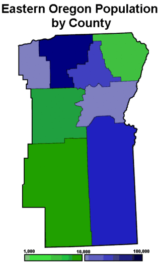
Eastern Oregon is a region of the U.S. state of Oregon. It is not an officially recognized geographic entity; thus, the boundaries of the region vary according to context. It is sometimes understood to include only the eight easternmost counties in the state; in other contexts, it includes the entire area east of the Cascade Range. Cities in the basic eight-county definition include Baker City, Burns, Hermiston, Pendleton, Boardman, John Day, La Grande, and Ontario. Umatilla County is home to the largest population base in Eastern Oregon, accounting for 42% of the region's residents. Hermiston, located in Umatilla County, is the largest city in the region, accounting for 10% of the population. Major industries include transportation/warehousing, timber, agriculture and tourism. The main transportation corridors are I-84, U.S. Route 395, U.S. Route 97, U.S. Route 26, U.S. Route 30, and U.S. Route 20.

<span class="mw-page-title-main">Interstate 86 (Idaho)</span> Short Interstate in Idaho

Interstate 86 (I-86) is an east–west intrastate Interstate Highway located entirely within the state of Idaho. It runs approximately 63 miles (101 km) from an intersection with I-84 east of Declo in rural Cassia County, to an intersection with I-15 in Chubbuck, just north of Pocatello. The highway is part of the main route from Boise and Twin Falls to Idaho Falls and the upper Snake River region.

<span class="mw-page-title-main">U.S. Route 30 in Oregon</span> Highway in Oregon

U.S. Route 30 (US 30) in the U.S. state of Oregon is a major east–west United States Numbered Highway that runs from its western terminus in Astoria to the Idaho border east of Ontario. West of Portland, US 30 generally follows the southern shore of the Columbia River; east of Portland, the highway has largely been replaced with Interstate 84 (I-84), though it is signed all the way across the state, and diverges from the I-84 mainline in several towns as a de facto business route. Out of all the states US 30 traverses, it spends the most time in Oregon. At 477.02 miles (767.69 km), it is also the longest road in the state.

<span class="mw-page-title-main">Mount Hood Highway</span>

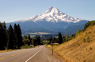
The Mount Hood Highway No. 26 is the Oregon Department of Transportation's designation for a 96.74-mile-long (155.69 km) highway from Portland east around the south side of Mount Hood and north via Bennett Pass to Hood River. It is marked as U.S. Route 26 from Portland to near Mount Hood and Oregon Route 35 the rest of the way to Hood River.

The Mount Hood Freeway is a partially constructed but never to be completed freeway alignment of U.S. Route 26 and Interstate 80N, which would have run through southeast Portland, Oregon. Related projects would have continued the route through the neighboring suburb of Gresham, out to the city of Sandy.

<span class="mw-page-title-main">Oregon Route 86</span> Highway in Oregon

Oregon Route 86 is an Oregon state highway running from Interstate 84 at Baker City to the Idaho state line at Oxbow. OR 86 comprises most of the Baker-Copperfield Highway No. 12. It is 67.82 miles (109.15 km) long and runs east–west. OR 86 has an unsigned spur near Halfway, which runs for 1.15 miles (1.85 km). Most of OR 86 is part of the Hells Canyon Scenic Byway.

<span class="mw-page-title-main">Interstate 80 in Utah</span> Section of Interstate highway in Utah, United States

Interstate 80 (I-80) is a part of the Interstate Highway System that runs from San Francisco, California, to Teaneck, New Jersey. The portion of the highway in the US state of Utah is 197.51 miles (317.86 km) long through the northern part of the state. From west to east, I-80 crosses the state line from Nevada in Tooele County and traverses the Bonneville Salt Flats—which are a part of the larger Great Salt Lake Desert. It continues alongside the Wendover Cut-off—the corridor of the former Victory Highway—US Route 40 (US-40) and the Western Pacific Railroad Feather River Route. After passing the Oquirrh Mountains, I-80 enters the Salt Lake Valley and Salt Lake County. A short portion of the freeway is concurrent with I-15 through Downtown Salt Lake City. At the Spaghetti Bowl, I-80 turns east again into the mouth of Parleys Canyon and Summit County, travels through the mountain range, and intersects the eastern end of I-84 near Echo Reservoir before turning northeast toward the Wyoming border near Evanston. I-80 was built along the corridor of the Lincoln Highway and the Mormon Trail through the Wasatch Range. The easternmost section also follows the historical routes of the first transcontinental railroad and US-30S.

<span class="mw-page-title-main">Interstate 84 in Utah</span> Section of Interstate Highway in Utah, United States

Interstate 84 (I-84) is a part of the Interstate Highway System that links Portland, Oregon, to I-80 near Echo, Utah. The 117.38-mile-long (188.90 km) segment in the US state of Utah is the shortest of any of the three states the western I-84 passes through and contains the eastern terminus of the highway. I-84 enters Box Elder County near Snowville before becoming concurrent with I-15 in Tremonton. The concurrent highways travel south through Brigham City and Ogden and separate near Ogden-Hinckley Airport. Turing east along the Davis County border, I-84 intersects US Route 89 (US-89) and enters Weber Canyon as well as Morgan County. While in Morgan County, I-84 passes the Devil's Gate-Weber Hydroelectric Power Plant and Devil's Slide rock formation. Past Morgan, the highway crosses into Summit County, past the Thousand Mile Tree before reaching its eastern terminus at I-80 near Echo.

<span class="mw-page-title-main">Interstate 84 in Idaho</span> Highway in Idaho

Interstate 84 (I-84) in the U.S. state of Idaho is a major Interstate Highway that traverses the state from the Oregon state line in the northwest to Utah state line in the southeast. It primarily follows the Snake River across a plain that includes the cities of Boise, Mountain Home, and Twin Falls. The highway is one of the busiest in Idaho and is designated as the Vietnam Veterans Memorial Highway.

<span class="mw-page-title-main">Interstate 84 in Oregon</span> Interstate highway in Oregon

Interstate 84 (I-84) in the U.S. state of Oregon is a major Interstate Highway that traverses the state from west to east. It is concurrent with U.S. Route 30 (US 30) for most of its length and runs 376 miles (605 km) from an interchange with I-5 in Portland to the Idaho state line near Ontario. The highway roughly follows the Columbia River and historic Oregon Trail in northeastern Oregon, and is designated as part of Columbia River Highway No. 2 and all of the Old Oregon Trail Highway No. 6; the entire length is also designated as the Vietnam Veterans Memorial Highway. I-84 intersects several of the state's main north–south roads, including US 97, US 197, I-82, and US 395.

<span class="mw-page-title-main">Idaho State Highway 55</span> State highway in Idaho, United States

State Highway 55 (SH-55) is an Idaho highway from Marsing to New Meadows, connecting with US-95 at both ends.

<span class="mw-page-title-main">U.S. Route 30 in Idaho</span> US Highway section within the state of Idaho

U.S. Route 30 (US 30) runs northwest–southeast across the southern half of lower Idaho for 455.481 miles (733.026 km). US 30 enters the state from Oregon across the Snake River in Fruitland and exits into Wyoming east of Dingle. US 30 runs through the large population centers of Boise, Twin Falls, and Pocatello, as well as a plethora of smaller communities from Fruitland to Montpelier. The Thousand Springs Scenic Byway is a picturesque section of US 30 in southern Idaho between the towns of Bliss and Buhl, dipping down into the Hagerman Valley and a canyon of the Snake River.

<span class="mw-page-title-main">U.S. Route 26 in Idaho</span> U.S. Highway section within the state of Idaho

U.S. Highway 26 (US-26) runs east–west across south central Idaho for 402.5 miles (647.8 km). US-26 enters the state from Oregon across the Snake River east of Nyssa, Oregon, concurrent with US-20 and exits into Wyoming northwest of Alpine. US-26 runs through the large population centers of Boise and Idaho Falls, as well as the smaller communities of Parma, Notus, Garden City, Shoshone, Richfield, Carey, Arco, Blackfoot, Swan Valley, and Irwin.

<span class="mw-page-title-main">Special routes of U.S. Route 30</span> Highway system

Several special routes of U.S. Route 30 exist. In order from west to east they are as follows.

<span class="mw-page-title-main">U.S. Route 20 in Idaho</span> Section of U.S. Highway in Idaho, United States

U.S. Highway 20 (US 20) is the portion of an east–west United States Numbered Highway in the state of Idaho. It begins northwest of Parma at the Oregon state line and enters Montana 9.6 miles (15.4 km) away from the Yellowstone National Park west entrance.

References

  1. 1 2 Starks, Edward (January 27, 2022). "Table 1: Main Routes of the Dwight D. Eisenhower National System of Interstate and Defense Highways as of December 31, 2021". Route Log and Finder List. Federal Highway Administration . Retrieved May 2, 2022.
  2. " "Idaho S1227" (PDF). Archived from the original (PDF) on December 22, 2014. Retrieved August 14, 2014."
  3. "Senate Bill 461" via OregonLive.
  4. 1 2 "Highway Resolutions: Route 84". Utah Department of Transportation. Retrieved May 18, 2008.
  5. Njus, Elliot (February 29, 2016). "Speed limits jump this week on some Oregon highways". OregonLive. Retrieved August 13, 2019.
  6. Staff (July 21, 2014). "ITD: Interstate speed limits going up to 80 mph, for real this time". Idaho Statesman . Retrieved September 15, 2014.
  7. Unknown (1871). "The Devil's Slide, Weber Canyon, Utah". California Digital Library, Board of Regents, University of California. Retrieved January 6, 2007.
  8. Hayden, F.V.; Davis, Daniel M. "Sun Pictures of Rocky Mountain Scenery, Photographic Collection". Utah State University Special Collections and Archives. Archived from the original on January 12, 2007. Retrieved January 6, 2007.
  9. "Utah State Legislature". Le.utah.gov. Archived from the original on February 22, 2014. Retrieved January 29, 2013.
  10. Bureau of Public Roads (April 27, 1939). Toll Roads and Free Roads. Washington, DC: Government Printing Office. p. 17. OCLC   2843728 . Retrieved June 21, 2018 via HathiTrust.
  11. Public Roads Administration; American Association of State Highway Officials (August 14, 1957). Official Route Numbering for the National System of Interstate and Defense Highways as Adopted by the American Association of State Highway Officials (Map). Scale not given. Washington, DC: Public Roads Administration. Retrieved May 4, 2014.
  12. "Interstate 82N Changed to 80N". Idaho State Journal . Pocatello, Idaho. July 5, 1958. p. 8. Retrieved June 21, 2018 via Newspapers.com.
  13. American Automobile Association (June 1958). National System of Interstate and Defense Highways, as of June, 1958 (Map). Washington, DC: American Automobile Association. LCCN   2011593044 . Retrieved June 21, 2018 via Library of Congress.
  14. "U.S. OKs Mt. Hood Freeway". The Oregon Journal. January 25, 1969. p. 1.
  15. "State To Explain Two Proposals For Route Of Mt. Hood Freeway From Willamette East". The Oregonian. April 10, 1969. p. 35.
  16. Mesh, Aaron (November 4, 2014). "Feb. 4, 1974: Portland kills the Mount Hood Freeway". Willamette Week . Retrieved October 26, 2021.
  17. "Interstate 84 – Idaho". Idaho Transportation Department. May 2006. Archived from the original on September 1, 2010. Retrieved June 21, 2018.
  18. Rand McNally (2014). The Road Atlas (Walmart ed.). Chicago: Rand McNally. pp. 31, 84–85, 102. ISBN   978-0-528-00771-2.
Template:Attached KML/Interstate 84 (Oregon–Utah)
KML is from Wikidata