Dunoon is the main town on the Cowal peninsula in the south of Argyll and Bute, Scotland. It is located on the western shore of the upper Firth of Clyde, to the south of the Holy Loch and to the north of Innellan. As well as forming part of the council area of Argyll and Bute, Dunoon also has its own community council. Dunoon was a burgh until 1976.

The River Forth is a major river in central Scotland, 47 km (29 mi) long, which drains into the North Sea on the east coast of the country. Its drainage basin covers much of Stirlingshire in Scotland's Central Belt. The Gaelic name for the upper reach of the river, above Stirling, is Abhainn Dubh, meaning "black river". The name for the river below the tidal reach is Uisge For.

Cowal is a rugged peninsula in Argyll and Bute, on the west coast of Scotland. It is bounded on the west by Loch Fyne and on the east by Loch Long and the Firth of Clyde. The Kyles of Bute separate it from Bute to the south.

Turriff is a town and civil parish in Aberdeenshire in Scotland. It lies on the River Deveron, about 166 feet (51 m) above sea level, and has a population of 5,708. In everyday speech it is often referred to by its Scots name Turra, which is derived from the Scottish Gaelic pronunciation.

Abbotrule is a hamlet south of the B6357 road, in the Scottish Borders area of Scotland, on Rule Burn, east of the Rule Water. Places nearby include Bedrule, Hallrule, Spittal-on-Rule, Ruletownhead, Bonchester Bridge, Denholm, Southdean, Hobkirk, Ferniehirst Castle and the Wauchope Forest.

Tullibody is a town set in the Central Lowlands of Scotland. It lies north of the River Forth near to the foot of the Ochil Hills within the Forth Valley. The town is 1.8 miles (2.9 km) south-west of Alva, 1.8 miles (2.9 km) north-west of Alloa and 4.0 miles (6.4 km) east-northeast of Stirling. The town is part of the Clackmannanshire council area.

Leurbost is a village on the east coast of the Isle of Lewis in the Outer Hebrides of Scotland. It is approximately 6 miles south of Stornoway on the road to Harris. It is the main settlement in the area of the island known as North Lochs. Leurbost is within the parish of Lochs.

Torphichen is a historic small village located north of Bathgate in West Lothian, Scotland. The village is approximately 18 miles (29 km) west of Edinburgh, 7 miles (11 km) south-east of Falkirk and 4 miles (6.4 km) south-west of Linlithgow. The village had a population of 570 in the and a population of 710 in 2016. Torphichen's placename may be Gaelic in origin, e.g., "Tóir Féichín", Tor Fithichean, or partly from Brythonic "tre fychan" or small hill.

Auchtertool is a small village in Fife, Scotland. It is 4 miles west of Kirkcaldy. The name is from the Gaelic uachdar, meaning upland or heights above the Tiel burn. The Tiel Burn flows a few hundred yards south of the kirk and village, which was formerly known as Milton of Auchtertool. The parish belonged to the diocese of Dunkeld, having been given to Bishop Gregory by King David I in the twelfth century. Soon after, the church was given to the priory of Inchcolm.
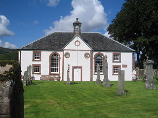
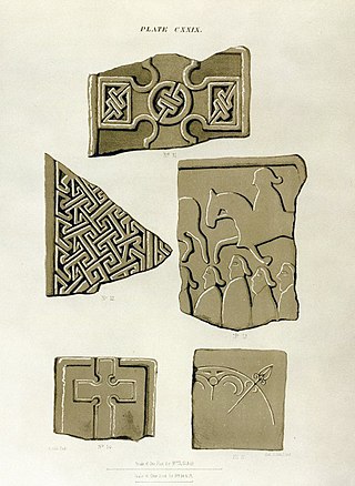
Kilmodan is a civil parish situated on the Cowal Peninsula, in Argyll and Bute, in Scotland. It includes the valley of Glendaruel and surrounding areas, with Kilmodan Church located in the Clachan of Glendaruel. The alternative historical spelling, Kilmadan, is no longer used.
Timsgarry is a village on the Isle of Lewis, in the Outer Hebrides, Scotland. Timsgarry is home to the Baile na Cille Church and the Uig Museum, noted for its giant Chessmen, discovered in the sands in 1831.
Kingarth is a historic village and parish on the Isle of Bute, off the coast of south-western Scotland. The village is within the parish of its own name, and is situated at the junction of the A844 and B881. In the Early Middle Ages it was the site of a monastery and bishopric and the cult centre of Saints Cathan and Bláán.
Contin Island is an inhabited riverine islet in Ross and Cromarty within the Highland council area of Scotland. Located in the Black Water, a tributary of the River Conon, it is 2 kilometres (1.2 mi) downstream from Rogie Falls and is connected to the village of Contin by a road bridge and footbridge.
Telford Parliamentary church also known as the Telford Kirks are a series of presbyterian churches in Scotland built with money voted from the parliament of the United Kingdom as a result of the Church of Scotland Act 1824 for a grant of £50,000, designed by the surveyor William Thomson and built by the Scottish stonemason and architect Thomas Telford. In total, 32 churches were built and many are still in use today. Others have been abandoned, e.g. at Stoer, while others were destroyed and rebuilt, e.g. at Tobermory, while others have been converted to dwellings.

Alexander Laing was a Scottish architect who was mainly involved in house and castle design.
The Drainie carved stones are a collection of 32 Pictish stones originating from the important early medieval monastic settlement of Kinneddar on the outskirts of the modern town of Lossiemouth in Moray, Scotland. Despite their name the majority were discovered at Kinneddar - the location of the manse of the parish of Drainie from which they take their name - rather than the separate settlement of Drainie which lay several miles to the west.

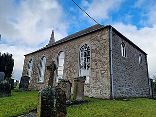
Inverchaolain Church is a former Church of Scotland church building in Inverchaolain, Argyll and Bute, Scotland. Located on the eastern shores of Loch Striven, just north of Inverchaolain Burn, the church was built in 1912. It is the fourth church on the site. There is a possibility that the second church, rumoured to be dedicated to Saint Bridget, was located about 200 metres (660 ft) northeast of the present structure.
William Macdonald Mackenzie was a Scottish architect, prominent in the first half of the 19th century. He designed several notable buildings in Scotland, mostly manses and church buildings.
Libberton is a village and historical parish in South Lanarkshire. The village is approximately 2 miles (3.2 km) north of Quothquan and 2.3 miles (3.68 km) south-east of Carnwath. The nearest rivers are the South Medwyn River, the North Medwyn River and the River Clyde which lies the east of the village.