
Gujranwala is a city and capital of Gujranwala Division located in Pakistan. It is also known as "City of Wrestlers" and is quite famous for its food. It is the 5th most populous city proper after Karachi, Lahore, Faisalabad and Rawalpindi respectively. Founded in the 18th century, Gujranwala is a relatively modern town compared to the many nearby millennia-old cities of northern Punjab. The city served as the capital of the Sukerchakia Misl state between 1763 and 1799, and is the birthplace of the founder of the Sikh Empire, Maharaja Ranjit Singh.

Rafah is a Palestinian city in the southern Gaza Strip. It is the capital of the Rafah Governorate of the State of Palestine, located 30 kilometers (19 mi) south-west of Gaza City. In 2017, Rafah had a population of 171,889. As a result of massive bombardment and ground assaults in Gaza City and Khan Yunis by Israel during the Israel–Hamas war, about 1.4 million people are believed to be sheltering in Rafah as of February 2024.
Abéché is the fourth largest city in Chad and is the capital of Ouaddaï Region. It has within it the remnants of the ancient capital, including palaces, mosques, and the tombs of former sultans.

Bosaso, historically known as Bender Cassim is a city in the northeastern Bari province (gobol) of Somalia. It is the seat of the Bosaso District. Located on the southern coast of the Gulf of Aden, the municipality serves as the region's commercial capital and is a major seaport within the autonomous Puntland state.

Dadaab is a semi-arid town in Garissa County, Kenya. It is the site of a UNHCR base hosting 302,805 registered refugees and asylum seekers in three camps as of 31 October 2023, making it one of the largest in the world behind Kutupalong refugee camp. The centre is run by the United Nations High Commissioner for Refugees, and its operations are financed by foreign donors. In 2013, UNHCR, the governments of Kenya and Somalia signed a tripartite agreement facilitating the repatriation of Somali refugees at the complex.

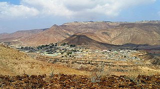
Gabiley, also known as Gebiley, is a city in the Maroodi Jeex region of Somaliland.
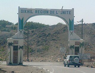
Dikhil is a town in the western Dikhil Region of Djibouti. Lying east of Lake Abbe, It is situated about 122 km (76 mi) southwest of Djibouti City and 12 km (7.5 mi) north of the border with Ethiopia. It serves as the administrative centre of the Dikhil Region, and is home to the Afar and Somali ethnic groups. The town develops gardens and fruit trees.

Cox's Bazar is a city, fishing port, tourism centre, and district headquarters in southeastern Bangladesh. Cox's Bazar Beach, one of the most popular tourist attractions in Bangladesh, is the longest uninterrupted natural beach in the world. Located 150 km (93 mi) south of the city of Chittagong, Cox's Bazar is also known by the name Panowa, which translates literally as "yellow flower." An old name was "Palongkee". Kutupalong refugee camp, the world's largest refugee camp, is in Cox's Bazar.

Gulu is a city in the Northern Region of Uganda. It is the commercial and administrative centre of Gulu District.

Gandhidham, initially known as Sardarganj, located in the eastern part of Kutch district in the state of Gujarat and it is the largest and most populous city in (Kachchh) Kutch District, Gujarat, India. It was created in the early 1950s for the resettlement of Sindhi Hindu refugees from Sindh in the aftermath of the partition of India. It was named after M.K. Gandhi. An economic capital of Kutch and a growing area for families and retirees. According to the Cesus-2011, Gandhidham is Gujarat's 8th most populous city. It is a popular destination for conventions, business, and meetings.
Borama is the largest city of the northwestern Awdal region of Somaliland. The commercial seat of the province, it is situated near the border with Ethiopia.
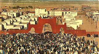
Tindouf is the main town, and a commune in Tindouf Province, Algeria, close to the Mauritanian, Western Saharan and Moroccan borders. The commune has a population of around 160,000, but the census and population estimates do not count the Sahrawi refugees, making the population as of the 2008 census 45,966, up from 25,266 in 1998, giving the town an annual population growth rate of 6.3%.

Tog Wajaale is a city on the border of Somaliland and Ethiopia. Tog Wajaale is the main border crossing for goods coming in and out of Somaliland, primarily from the port city of Berbera, Somaliland's main port.
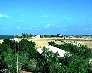
Loyada is a small town in Djibouti. Located in the Arta Region, it is the only official border crossing from Djibouti into Somaliland. It is situated on the west coast of Gulf of Aden, 25 kilometres (16 mi) from the capital, Djibouti.

Luuq is a city in the southwestern Gedo province of Somalia. It is one of the older settlements in the area. It is the seat of the Luuq District. The town is located in a bend of the Juba River, where the watercourse flows down from north to south in a horseshoe shape. Luuq is also known as Luuq Gan naane.
Bike is a town in central Ethiopia of the Somali Region in the Sitti Zone. It is located 72 km west of Shinile. The town is located on the main railway between Djibouti City and Addis Ababa.
Weʽa or Wêʽa is a town in the Arta Region of Djibouti. It is located on the RN-1 National Highway, which connects it to Djibouti City, located some 37 kilometres to the east. Weʽa is the second largest city in the Arta Region after Arta and before Damerjog. It is the primary transportation hub in western Djibouti via highway. The town is situated in a small valley.

Buloburde, also spelled Buloburti or Bulobarde, is a city in Somalia's central Hiran region.
Sheder, also known as Sheed-dheer meaning Looked far or Shedher, is a town located in the northeastern Fafan Zone in the Somali region of Ethiopia near the border with Somaliland on the main trade route between Jijiga and the sea. It is one of the largest towns in the Awbare district.

Hirshabelle, officially Hirshabelle State of Somalia, is a Federal Member State in south-central Somalia. It is bordered by Galmudug state of Somalia to the north, South West State of Somalia and Banadir region to the south, Ethiopia to the west and the Indian Ocean to the east. Jowhar is the capital state.
