Jankent

Last updated
Jankent
Relief Map of Kazakhstan.png
Archaeological site icon (red).svg
Shown within Kazakhstan
West Asia non political with water system.jpg
Archaeological site icon (red).svg
Jankent (West and Central Asia)
Alternative nameDzhankent, Yangikent
Location Kazaly, Kazakhstan
Coordinates 45°36′44″N61°55′16″E / 45.61222°N 61.92111°E / 45.61222; 61.92111 Coordinates: 45°36′44″N61°55′16″E / 45.61222°N 61.92111°E / 45.61222; 61.92111
TypeFortified settlement
Area16 ha (40 acres)
History
Founded7th/10th centuries AD
Abandoned11/12th centuries AD
Cultures Oghuz Turks
Site notes
Excavation dates2005-19

Jankent (Dzhankent, Yangikent, Eni-Kent, Djanikand, Yenikent, Yanikand, all meaning New Town in Turkic; al-Karyat al-hadith, Dihi Naw, Shehrkent) is a deserted town east of the Aral Sea in modern Kazakhstan. It is known from Arab writings of the 10th century AD as the capital of the steppe empire of the Oghuz Turks. Archaeological research has provided information about the appearance of the town and confirmed the date, but also points to earlier origins.

Contents

Description

Jankent is located on the left bank of the lower Syr Darya, about 25 kilometres (16 mi) southwest from the town of Kazaly (formerly Kazalinsk), in the Kazaly district of Kyzylorda province in Kazakhstan. Today, it is a scheduled monument marked by the ruins of walls which are up to 7 metres (23 ft) high in places and enclose an area of 16 hectares (40 acres) in the dried-out river delta of the Syr-Darya. Visible elements of the lay-out include: a broadly rectangular wall circuit orientated east-west, given a T-shaped appearance by an eastern ‘cross-bar’; a regular lay-out in the western half of the interior; gates in the eastern and western walls; a separately enclosed ‘citadel’ in the north-western corner; a semicircular annexe attached to the northern wall; and a low mound outside the east gate suggesting an external structure. [1]

Historical evidence

Arab geographers of the 10th century (Al-Masudi, Al-Idrisi) mention a town of the Oghuz called Jengi-Kent, two sources (Ibn Rustah and Ibn Hawqal) even call it the seat of the Oghuz Yabgu (khan of second rank). As early as the 1920s, the orientalist V.V. Bartold identified Jankent as the site of the historical Jengi-Kent. [2] The town is also identified as the home town of the Kazakh cultural hero, Korkyt Ata, the reputed inventor of the traditional two-stringed lute (kobyz).

Archaeological evidence

Aerial photo of Jankent, with locations of archaeological sections 2005-2014 Dzhankent aerial photo with sections.JPG
Aerial photo of Jankent, with locations of archaeological sections 2005-2014

Jankent was first mentioned by Russian army topographers in the early 19th century, and visited in 1867 by the orientalist P. Lerkh. [3] In 1946, a team of the Chorasmian Expedition surveyed the site and photographed it from the air. On the basis of the lay-out of the site and the finds collected during this visit, the director of the expedition, S.P. Tolstov, dated Jankent to the 1st – 11th centuries AD. [4] Two other members of the expedition, N.I. Igonin and B.V. Andrianov, drew up an improved plan of Jankent in 1963.

Systematic excavations have been carried out at Jankent since 2005 by various teams, mainly the Institute of Ethnology and Anthropology, Russian Academy of Sciences (IEA RAN, Moscow) with Korkyt Ata State University of Kyzylorda (Kazakhstan) and the University of Tübingen (Germany); and the Margulan Institute of Archaeology, Kazakh Ministry of Education and Science (MON), later its commercial branch ‘Archaeological Expertise’ (Almaty, Kazakhstan), with Pavlodar State University (Kazakhstan).

Lower town

Composite picture of building remains uncovered in the lower town of Jankent in 2005-6 Dzhankent section 1 panorama.jpg
Composite picture of building remains uncovered in the lower town of Jankent in 2005-6

In the centre of the town, essential discoveries in Trench P1 included a built-up area (living quarters) with a lay-out in Central Asian style along a street, and a possible metal workshop, all dated to the 9th/10th centuries on the basis of coin finds. [5] Later excavations in this area since 2011 have been carried out to a greater depth, revealing several building phases of earlier date.

Citadel

View of citadel of Jankent from the north, with corner tower uncovered (bright feature at upper right) (photo H. Harke 2013) Dzhankent citadel & tower 2013.JPG
View of citadel of Jankent from the north, with corner tower uncovered (bright feature at upper right) (photo H. Härke 2013)

At the junction of the citadel wall and northern town wall (Trench P2), occupation layers with complex stratification were found by the Russian-Kazakh-German team down to a depth of more than 8 metres (26 ft) from the current top of the citadel wall. [6] Radiocarbon dates from this trench produced a range of (cal.) AD 786/923 to 961/1095. [7] The extension of the trench at the top of the citadel wall since 2012 has uncovered semi-circular towers on the wall. In 2019, a 9th/10th century pottery vessel from the outside of the northern base of the citadel wall was found to contain three eggs with Arabic writing on them.

Fieldwork in the interior of the citadel (Trench P3) by the Almaty and Pavlodar teams has reportedly uncovered only two layers of 9th/10th century date, the lower one of which produced building remains and a street. [8] Lack of detailed publication precludes an independent verification of these claims.

Town wall

A trench in the kink of the southern town wall (Trench P5) proved that the T-shaped lay-out of the wall circuit was part of the original design, similar to earlier enclosures further south in the neighbouring civilization of Khorezm (Chorasmia, Khwarazm). Settlement layers with 7th/8th century pottery were found here under the base of the town wall, confirmed by radiocarbon dates for this trench ranging from (cal.) AD 674/799 to 906/1057. [9] An earlier trench (P4) in the corresponding kink in the northern wall is briefly mentioned, but not documented, in a summary report by the Almaty and Pavlodar teams. [10]

Plan of Jankent by the Chorasmian Expedition (1963), with additional annotations showing elements of the town (I.A. Arzhantseva 2015) Dzhankent plan 1963 English annotations.jpg
Plan of Jankent by the Chorasmian Expedition (1963), with additional annotations showing elements of the town (I.A. Arzhantseva 2015)

Geophysics, geomorphology, soil science

Since 2011, a team from Moscow State University has applied several non-destructive survey techniques to large parts of the site. [11] The results show that the citadel interior was probably located on a natural elevation. There was a regular lay-out and dense arrangement of buildings across much of the western half of the interior, in contrast to larger building complexes ('estates') in a loose arrangement in the eastern half. The annexe attached to the northern town wall proved to be completely empty. In 2019, a Moscow geomorphology-pedology team carried out mechanical coring on a grid across the site. Preliminary results include deep stratification of cultural layers several metres down found in most cores; the large regular feature on the inside of the northern wall is not an 'estate' (as originally thought), but a massive clay platform; and the substantial structure outside the east gate, hypothesized to be the remains of a caravanserai, are a natural island in a (now dry) river bed dating to before the beginnings of settlement at Dzhankent.

Current state of knowledge

Pottery types found in 9th/10th century AD layers of Jankent: 1 - Dzhetyasar, 2 - Oghuz, 3 - Khorezmian (created by I.A. Arzhantseva 2012) Dzhankent pottery types.jpg
Pottery types found in 9th/10th century AD layers of Jankent: 1 - Dzhetyasar, 2 - Oghuz, 3 - Khorezmian (created by I.A. Arzhantseva 2012)

On the basis of their findings since 2011, the Russian-Kazakh-German team suggest that the earliest settlement at this site was founded in the 7th century by a displaced population of the Dzhetyasar culture further upriver. [12] This coincided with the beginnings of trading activities along the early medieval branch of the Northern Silk Road running through this region. The enclosed town of Jankent was then built in the 9th or 10th century, some time after the arrival of the Turkic Oghuz on the steppes north of the Syr-darya. The town population may have been mixed as the material culture found at the site derives from three different cultural components: Oghuz nomads, sedentary Dzhetyasar culture, and Khorezmian civilization. In the 10th and 11th centuries, the town was the capital of the Oguz Yabgu State, and most likely it also functioned as a trading and craft centre for the largely nomadic population of the polity, being located on the intersection of the Northern Silk Road with the north-south caravan route from the Volga region to Khorezm.

The town was abandoned some time between the 12th and 14th century AD for unknown reasons, perhaps because of a shift of the river channels in the Syr-Darya delta, a change in trading patterns, or because of political developments. Other Turkic peoples, the Kipchaks and Kimeks of the Kimek Kaganate, destroyed the Oghuz polity in the 12th century. Around that time, Selçuk Bey and his Kınık tribe headed to Persia to found their own Muslim state which would eventually become the Great Seljuq Empire.

Related Research Articles

History of Kazakhstan Historical development of Kazakhstan

Kazakhstan, the largest country fully within the Eurasian Steppe, has been a historical crossroads and home to numerous different peoples, states and empires throughout history.

The vast territory of Kazakhstan spans across 2,700,000 km2 (1,000,000 sq mi). The population density is low in Kazakhstan, and the centers of industry and agriculture are spread out and remote from world markets.

Syr Darya River in Central Asia

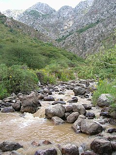
The Syr Darya, historically known as the Jaxartes, is a river in Central Asia. The name, a borrowing from the Persian language, literally means Syr Sea or Syr River, and sometimes it is referred to in this way. It originates in the Tian Shan Mountains in Kyrgyzstan and eastern Uzbekistan and flows for 2,256.25 kilometres (1,401.97 mi) west and north-west through Uzbekistan and southern Kazakhstan to the northern remnants of the Aral Sea. It is the northern and eastern of the two main rivers in the endorheic basin of the Aral Sea, the other being the Amu Darya (Jayhun).

Almaty Largest city in Kazakhstan

Almaty, or Alma-Ata, and formerly Verniy (1854–1921), is the largest city in Kazakhstan, with a population of about 2 million. It was the capital of Kazakhstan from 1929 to 1997, when the government relocated the capital to Akmola.

Baikonur city in Kazakhstan holding a Russian spaceport

Baikonur, formerly known as Leninsk, is a city of republic significance in Kazakhstan on the northern bank of the Syr Darya river, rented and administered by the Russian Federation as an enclave. It was constructed to service the Baikonur Cosmodrome and was officially renamed Baikonur by Russian president Boris Yeltsin on December 20, 1995. During the Soviet period, it was sometimes referred to as Звездоград, Russian for 'Star City'.

Turkistan (city) City in southern Kazakhstan

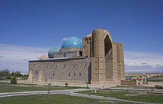
Turkistan, is a city and the administrative center of Turkistan Region of Kazakhstan, near the Syr Darya river. It is situated 160 km (100 mi) north-west of Shymkent on the Trans-Aral Railway between Kyzylorda to the north and Tashkent to the south. Its population has increased within ten years from 102,505 to 142,899. Turkistan's most prominent historical and cultural asset is the Mausoleum of Khoja Ahmed Yasawi, a UNESCO World Heritage site. The city is served by Hazrat Sultan International Airport.

Otrar Place in South Kazakhstan Province, Kazakhstan

Otrar or Utrar, also called Farab, is a Central Asian ghost town that was a city located along the Silk Road in Kazakhstan. Otrar was an important town in the history of Central Asia, situated on the borders of settled and agricultural civilizations. It was the center of a great oasis and political district, commanding a key point connecting Kazakhstan with China, Europe, Near and Middle East, Siberia and Ural.

Turkistan Region Region of Kazakhstan

Turkistan Region, previously South Kazakhstan Region is the southernmost region of Kazakhstan. Population: 2,469,367 ; 1,978,339. Its capital is Turkistan, formerly Shymkent in 2018. Other cities in South Kazakhstan include Sayram, Kentau, Arys, Shardara, Zhetisai, Saryagash, and Lenger. This region and Atyrau Region are Kazakhstan's two smallest regions; both are about 117,300 square kilometers in area. Turkistan Region borders the neighboring country of Uzbekistan, as well as three other Kazakhstan regions: Karaganda Region, Kyzylorda Region, and Jambyl Region. The Syr Darya passes through the region, on its way to the Aral Sea. Also, an oil pipeline runs from Turkmenabat, Turkmenistan to Omsk, Russia through South Kazakhstan. Oil, lead and zinc are refined in Shymkent.

Kyzylorda City in south-central Kazakhstan

Kyzylorda, formerly known as Kzyl-Orda, Ak-Mechet (Ак-Мечеть), Perovsk (Перовск), and Fort-Perovsky (Форт-Перовский), is a city in south-central Kazakhstan, capital of Kyzylorda Region and former capital of the Kazakh ASSR from 1925 to 1927.

Central Asian cuisine Culinary traditions of Central Asia

Central Asian cuisine has been influenced by Persian, Indian, Arab, Turkish, Chinese, Mongol and Russian cultures, as well as the culinary traditions of other varied nomadic and sedentary civilizations. Contributing to the culinary diversity were the migrations of Uyghur, Slav, Korean, Tatar, Dungan and German people to the region.

Oghuz Yabgu State 766–1055 Turkic state in Central Asia

The Oghuz Yabgu State was a Turkic state, founded by Oghuz Turks in 766, located geographically in an area between the coasts of the Caspian and Aral Seas. Oghuz tribes occupied a vast territory in Kazakhstan along the Irgiz, Yaik, Emba, and Uil rivers, the Aral Sea area, the Syr Darya valley, the foothills of the Karatau Mountains in Tien-Shan, and the Chui River valley. The Oghuz political association developed in the 9th and 10th centuries in the basin of the middle and lower course of the Syr Darya and adjoining the modern western Kazakhstan steppes.

Narxoz University is a higher education institution in Kazakhstan providing training in economics, business, finance, and law, located in the city of Almaty. Founded in 1963, the current name since 2016. The university includes 3 schools in the areas of training, research centers, scientific and educational departments, 5 representative offices in the regions of Kazakhstan, and an economic college.

Index of Kazakhstan-related articles Wikipedia index

Below is the list of Kazakhstan related articles.

Kangar union Turkic union founded in the 7th century

Kangar union, Kazakh: Қaңғар Oдағy was a Turkic state in the territory of the entire modern Kazakhstan without Zhetysu. The ethnic name Kangar is an early medieval name for the Kangly people, who are now part of the Kazakh, Uzbek, and Karakalpak nations. The capital of the Kangar union was located in the Ulytau mountains. The Pechenegs, three of whose tribes were known as Kangar, after being defeated by the Oghuzes, Karluks, and Kimek-Kypchaks, attacked the Bulgars and established the Pecheneg state in Eastern Europe.

Bek Air

Bek Air was a Kazakh airline headquartered in Oral.

Shymkent City of republican significance, Kazakhstan

Shymkent, known until 1993 as Chimkent ; Russian: Чимкент, romanized: Chimkent ), is a city in Kazakhstan. It is near the border with Uzbekistan. It is one of three Kazakh cities which have the status equal to that of a region. It is the third-most populous city in Kazakhstan, behind Almaty and Nur-Sultan, with an estimated population of 1,002,291 as of 1 June 2018. According to regional and city officials, the millionth resident of Shymkent was born on 17 May 2018. It is a regional cultural centre.

Eastern Orthodoxy in Kazakhstan

The Eastern Orthodox Church in Kazakhstan is a metropolitan district or metropolia of the Russian Orthodox Church. Although not autonomous or fully self-governing like the Ukrainian Orthodox Church under the Moscow Patriarchate, the Church in Kazakhstan has been given some self-government, with jurisdiction over all Orthodox Christians in Kazakhstan. Most of its members are ethnic Russians, Ukrainians, and Belarusians resident in Kazakhstan.

Sighnaq was an ancient city in Central Asia, it was the capital of the Blue Horde, although the city is almost unknown. The region in which Sighnaq was situated was called Farab, it was located between Isfijab and Jand. The name means 'place of refuge', a name that is found also in other regions, especially in Transcaucasia.

History of the central steppe Aspect of history

This is a short History of the central steppe, an area roughly equivalent to modern Kazakhstan. Because the history is complex it is mainly an outline and index to the more detailed articles given in the links. It is a companion to History of the western steppe and History of the eastern steppe and is parallel to the History of Kazakhstan and the History of central Asia.

References

  1. Arzhantseva, I.A., Karamanova, M.S., Härke, H., Ruzanova, S.A., Tazhekeev, A.A. & Modin, I.N. (2012). "Early medieval urbanization and state formation east of the Aral Sea: Fieldwork and international workshop 2011 in Kazakhstan". The European Archaeologist 37. 14-20. https://www.e-a-a.org/EAA/Publications/TEA/Archive/EAA/Navigation_Publications/TEA_content/Archive.aspx#37
  2. Bartold, V.V. (2002). Raboty po istorii i filologii turkskikh i mongol’skikh narodov. Moscow.
  3. Lerkh, P. (1870). Arkheologicheskaya poezdka v Turkestanskij kraj v 1867 g.. St. Petersburg; Arzhantseva, I.A. & Ruzanova, S.A. (2010). "Issledovanie ‘bolotnykh gorodishch’: arkhivy I novye materialy". In: Arkheologiya Srednej Azii i Kazakhstana 2010. 390-406; Arzhantseva, I.A. and Gorshenina, S. (2018). The patrimonial project of Dzhankent: Constructing a national symbol in the longue durée. Ancient Civilizations from Scythia to Siberia 24. 467-532.
  4. Tolstov, S.P. (1947). "Goroda Oguzov". Sovetskaya Etnografiya 1947 no. 3. 57-102.
  5. Kurmankulov, Zh.K., Arzhantseva, I.A, Zilivinskaya, E.D., Ruzanova, S.A. & Sydykova, Zh.T. (2007). Materialy Dzhankentskoj arkheologicheskoj ekspeditsii: Arkheologicheskie raboty na gorodishche Dzhankent v 2006 g. Kyzylorda; Arzhantseva, I.A., Zilivinskaya, E.D., Karamanova, M.S., Ruzanova, S.A., Utkel’baev, K.Z., Sydykova, Zh.T. & Bilalov, S.U. (2010). Svodnyj otchet ob arkheologicheskikh rabotakh na gorodishche Dzhankent v 2005-2007, 2009 gg. Kyzyl-Orda.
  6. Arzhantseva, I.A. and Tazhekeev, A.A. (2014, publ. 2016). Kompleksnie issledovaniya gorodishcha Dzhankent (Rabota 2011-2014 gg.) Almaty: Arys. ISBN   978-601-291-308-8.
  7. Institute of Geography, RAN, Moscow; Arzhantseva et al. (2012). More recent radiocarbon dates, as yet unpublished, go back to the late 6th/early 7th century; Curt-Engelhorn-Zentrum Archäometrie, Mannheim, Germany.
  8. Akhatov, G.A., Smagulov, T.N., Ganieva, A.S. & Amirgalina, G.T. (2008). Arkheologicheskie issledovaniya drevnego gorodishcha Jankent. Annual field report, Institute of Archaeology, Almaty ; Bajpakov, K.M., Voyakin, D.A. & Ilin, R.V. (2012). "The towns of Huwara and Yangikent, the old and new capitals of the Oguz state". Bulletin of the International Institute for Central Asian Studies 16. 22-44.
  9. Institute of Geography, RAN, Moscow; Arzhantseva et al. (2012).
  10. Akhatov et al. (2008).
  11. Arzhantseva, I.A., Modin, I.N. & Erokhin, S.A. (2013). "Geofizicheskie issledovaniya na Dzhankente". In: Trudy filiala Instituta arkheologii im. A.Kh. Margulana v g. Astana, vol. II. Astana. 179-186; and relevant chapters in Arzhantseva and Tahekeev (2014).
  12. Arzhantseva et al. (2012); Härke, H., Arzhantseva, I.A. and Tazhekeev, A. (2020). The early medieval town of Dzhankent (Kazakhstan): from initial hypothesis to new model. The European Archaeologist 66. 27-34. https://www.e-a-a.org/EAA/Publications/Tea/Tea_66/Research_news/EAA/Navigation_Publications/Tea_66_content/Research_news.aspx