
An ecosystem consists of all the organisms and the physical environment with which they interact. These biotic and abiotic components are linked together through nutrient cycles and energy flows. Energy enters the system through photosynthesis and is incorporated into plant tissue. By feeding on plants and on one another, animals play an important role in the movement of matter and energy through the system. They also influence the quantity of plant and microbial biomass present. By breaking down dead organic matter, decomposers release carbon back to the atmosphere and facilitate nutrient cycling by converting nutrients stored in dead biomass back to a form that can be readily used by plants and microbes.

The carbon cycle is that part of the biogeochemical cycle by which carbon is exchanged among the biosphere, pedosphere, geosphere, hydrosphere, and atmosphere of Earth. Other major biogeochemical cycles include the nitrogen cycle and the water cycle. Carbon is the main component of biological compounds as well as a major component of many minerals such as limestone. The carbon cycle comprises a sequence of events that are key to making Earth capable of sustaining life. It describes the movement of carbon as it is recycled and reused throughout the biosphere, as well as long-term processes of carbon sequestration (storage) to and release from carbon sinks.

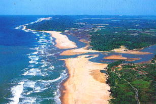
A swamp is a forested wetland. Swamps are considered to be transition zones because both land and water play a role in creating this environment. Swamps vary in size and are located all around the world. The water of a swamp may be fresh water, brackish water, or seawater. Freshwater swamps form along large rivers or lakes where they are critically dependent upon rainwater and seasonal flooding to maintain natural water level fluctuations. Saltwater swamps are found along tropical and subtropical coastlines. Some swamps have hammocks, or dry-land protrusions, covered by aquatic vegetation, or vegetation that tolerates periodic inundation or soil saturation. The two main types of swamp are "true" or swamp forests and "transitional" or shrub swamps. In the boreal regions of Canada, the word swamp is colloquially used for what is more formally termed a bog, fen, or muskeg. Some of the world's largest swamps are found along major rivers such as the Amazon, the Mississippi, and the Congo.

Wetlands, or simply a wetland, is a distinct ecosystem that is flooded or saturated by water, either permanently or seasonally. Flooding results in oxygen-free (anoxic) processes prevailing, especially in the soils. The primary factor that distinguishes wetlands from terrestrial land forms or water bodies is the characteristic vegetation of aquatic plants, adapted to the unique anoxic hydric soils. Wetlands are considered among the most biologically diverse of all ecosystems, serving as home to a wide range of plant and animal species. Methods for assessing wetland functions, wetland ecological health, and general wetland condition have been developed for many regions of the world. These methods have contributed to wetland conservation partly by raising public awareness of the functions some wetlands provide. Constructed wetlands are designed and built to treat municipal and industrial wastewater as well as to divert stormwater runoff. Constructed wetlands may also play a role in water-sensitive urban design.

Aquatic plants are plants that have adapted to living in aquatic environments. They are also referred to as hydrophytes or macrophytes to distinguish them from algae and other microphytes. A macrophyte is a plant that grows in or near water and is either emergent, submergent, or floating. In lakes and rivers macrophytes provide cover for fish, substrate for aquatic invertebrates, produce oxygen, and act as food for some fish and wildlife.

A marsh is - according to ecological definitions - a wetland that is dominated by herbaceous rather than woody plant species. More in general, the word can be used for any low-lying and seasonally waterlogged terrain. In Europe and in agricultural literature low-lying meadows that require draining and embanked polderlands are also referred to as marshes or marshland.

A grassland is an area where the vegetation is dominated by grasses (Poaceae). However, sedge (Cyperaceae) and rush (Juncaceae) can also be found along with variable proportions of legumes, like clover, and other herbs. Grasslands occur naturally on all continents except Antarctica and are found in most ecoregions of the Earth. Furthermore, grasslands are one of the largest biomes on earth and dominate the landscape worldwide. There are different types of grasslands: natural grasslands, semi-natural grasslands, and agricultural grasslands. They cover 31–69% of the Earth's land area.
Freshwater ecosystems are a subset of Earth's aquatic ecosystems. They include lakes, ponds, rivers, streams, springs, bogs, and wetlands. They can be contrasted with marine ecosystems, which have a larger salt content. Freshwater habitats can be classified by different factors, including temperature, light penetration, nutrients, and vegetation. There are three basic types of freshwater ecosystems: Lentic, lotic and wetlands. Freshwater ecosystems contain 41% of the world's known fish species.
An aquatic ecosystem is an ecosystem found in and around a body of water, in contrast to land-based terrestrial ecosystems. Aquatic ecosystems contain communities of organisms—aquatic life—that are dependent on each other and on their environment. The two main types of aquatic ecosystems are marine ecosystems and freshwater ecosystems. Freshwater ecosystems may be lentic ; lotic ; and wetlands.

A riparian zone or riparian area is the interface between land and a river or stream. In some regions, the terms riparian woodland, riparian forest, riparian buffer zone,riparian corridor, and riparian strip are used to characterize a riparian zone. The word riparian is derived from Latin ripa, meaning "river bank".
The UK Centre for Ecology & Hydrology (UKCEH) is a centre for excellence in environmental science across water, land and air. The organisation has a long history of investigating, monitoring and modelling environmental change. Research topics include: air pollution, biodiversity, chemical risks in the environment, extreme weather events, droughts, floods, greenhouse gas emissions, soil health, sustainable agriculture, sustainable ecosystems, water quality, and water resources management.

Marine ecosystems are the largest of Earth's aquatic ecosystems and exist in waters that have a high salt content. These systems contrast with freshwater ecosystems, which have a lower salt content. Marine waters cover more than 70% of the surface of the Earth and account for more than 97% of Earth's water supply and 90% of habitable space on Earth. Seawater has an average salinity of 35 parts per thousand of water. Actual salinity varies among different marine ecosystems. Marine ecosystems can be divided into many zones depending upon water depth and shoreline features. The oceanic zone is the vast open part of the ocean where animals such as whales, sharks, and tuna live. The benthic zone consists of substrates below water where many invertebrates live. The intertidal zone is the area between high and low tides. Other near-shore (neritic) zones can include mudflats, seagrass meadows, mangroves, rocky intertidal systems, salt marshes, coral reefs, lagoons. In the deep water, hydrothermal vents may occur where chemosynthetic sulfur bacteria form the base of the food web.
A boreal ecosystem is an ecosystem with a subarctic climate located in the Northern Hemisphere, approximately between 50° to 70°N latitude. These ecosystems are commonly known as taiga and are located in parts of North America, Europe, and Asia. The ecosystems that lie immediately to the south of boreal zones are often called hemiboreal. There are a variety of processes and species that occur in these areas as well.
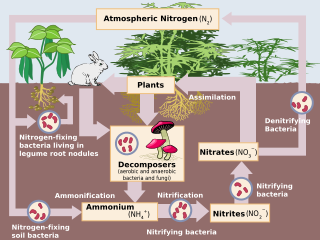
Human impact on the nitrogen cycle is diverse. Agricultural and industrial nitrogen (N) inputs to the environment currently exceed inputs from natural N fixation. As a consequence of anthropogenic inputs, the global nitrogen cycle (Fig. 1) has been significantly altered over the past century. Global atmospheric nitrous oxide (N2O) mole fractions have increased from a pre-industrial value of ~270 nmol/mol to ~319 nmol/mol in 2005. Human activities account for over one-third of N2O emissions, most of which are due to the agricultural sector. This article is intended to give a brief review of the history of anthropogenic N inputs, and reported impacts of nitrogen inputs on selected terrestrial and aquatic ecosystems.

Brazil once had the highest deforestation rate in the world and in 2005 still had the largest area of forest removed annually. Since 1970, over 700,000 square kilometres (270,000 sq mi) of the Amazon rainforest have been destroyed. In 2001, the Amazon was approximately 5,400,000 square kilometres (2,100,000 sq mi), which is only 87% of the Amazon's original size. According to official data, about 729,000 km² have already been deforested in the Amazon biome, which corresponds to 17% of the total. 300,000 km² have been deforested in the last 20 years.

Soil Moisture Active Passive (SMAP) is a NASA environmental monitoring satellite that measures soil moisture across the planet. It is designed to collect a global 'snapshot' of soil moisture every 2 to 3 days. With this frequency, changes from specific storms can be measured while also assessing impacts across seasons of the year. SMAP was launched on 31 January 2015. It was one of the first Earth observation satellites developed by NASA in response to the National Research Council's Decadal Survey.
Landscape limnology is the spatially explicit study of lakes, streams, and wetlands as they interact with freshwater, terrestrial, and human landscapes to determine the effects of pattern on ecosystem processes across temporal and spatial scales. Limnology is the study of inland water bodies inclusive of rivers, lakes, and wetlands; landscape limnology seeks to integrate all of these ecosystem types.
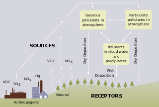
Freshwater acidification occurs when acidic inputs enter a body of fresh water through the weathering of rocks, invasion of acidifying gas, or by the reduction of acid anions, like sulfate and nitrate within a lake. Freshwater acidification is primarily caused by sulfur oxides (SOx) and nitrogen oxides (NOx) entering the water from atmospheric depositions and soil leaching. Carbonic acid and dissolved carbon dioxide can also enter freshwaters, in a similar manner associated with runoff, through carbon dioxide-rich soils. Runoff that contains these compounds may incorporate acidifying hydrogen ions and inorganic aluminum, which can be toxic to marine organisms. Acid rain is also a contributor to freshwater acidification. It is created when SOx and NOx react with water, oxygen, and other oxidants within the clouds.

Yadvinder Singh Malhi is professor of Ecosystem Science at the University of Oxford and a Jackson Senior Research Fellow at Oriel College, Oxford.

Fresh water or freshwater is any naturally occurring liquid or frozen water containing low concentrations of dissolved salts and other total dissolved solids. Although the term specifically excludes seawater and brackish water, it does include non-salty mineral-rich waters such as chalybeate springs. Fresh water may encompass frozen and meltwater in ice sheets, ice caps, glaciers, snowfields and icebergs, natural precipitations such as rainfall, snowfall, hail/sleet and graupel, and surface runoffs that form inland bodies of water such as wetlands, ponds, lakes, rivers, streams, as well as groundwater contained in aquifers, subterranean rivers and lakes. Fresh water is the water resource that is of the most and immediate use to humans.