
The Wildfowl & Wetlands Trust (WWT) is an international wildfowl and wetland conservation charity in the United Kingdom. Its patron is Prince Charles, and its president is Kate Humble.
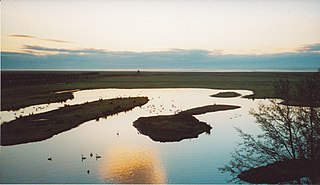
WWT Caerlaverock is wetland nature reserve in southwest Scotland, one of nine reserves in Britain operated by the Wildfowl and Wetlands Trust founded by Sir Peter Scott.

The Firth of Forth is the estuary (firth) of several Scottish rivers including the River Forth. It meets the North Sea with Fife on the north coast and Lothian on the south.

Dunbar is a town on the North Sea coast in East Lothian in the south-east of Scotland, approximately 30 miles east of Edinburgh and 30 miles from the English border north of Berwick-upon-Tweed.

Loch Fleet is a sea loch on the east coast of Scotland, located between Golspie and Dornoch. It forms the estuary of the River Fleet, a small spate river that rises in the hills east of Lairg. The loch was designated a National Nature Reserve (NNR) in 1998, and is managed by a partnership between Scottish Natural Heritage (SNH), the Scottish Wildlife Trust (SWT) and Sutherland Estates. The NNR extends to 1058 hectares, including the Loch Fleet tidal basin, sand dunes, shingle ridges and the adjacent pine woods, including Balbair Wood and Ferry Wood. The tidal basin of the loch covers over 630 ha, and forms the largest habitat on the NNR.

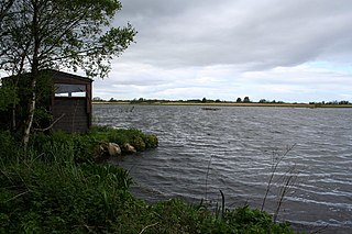
Montrose Basin is a nearly circular tidal basin which makes up part of the estuary of the River South Esk and which sits just inland of the town of Montrose in Angus on the east coast of Scotland. The basin is protected by a number of designations, it is mananged by the Scottish Wildlife Trust as a Wildlife Reserve, as well as being designated as a Local Nature Reserve, Site of Special Scientific Interest,, a Special Protection Area and a Ramsar Site.

The Duddon Estuary is the sandy, gritty estuary of the River Duddon that lies between Morecambe Bay and the west Cumbrian coast.

Cemlyn Bay is a bay on the northwest coast of Anglesey, North Wales, approximately 2.5 km west of Wylfa nuclear power station, within the community of Cylch-y-Garn.

The Ribble and Alt Estuaries lie on the Irish Sea coast of the counties of Lancashire and Merseyside in north-west England, and form the boundaries of a number of conservation schemes.
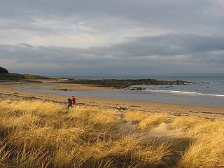
Yellowcraig, less commonly known as Broad Sands Beach, is a coastal area of forest, beach and grassland in East Lothian, south-east Scotland. Yellowcraig is partly within the Firth of Forth Site of Special Scientific Interest (SSSI). It is bordered to the north by the Firth of Forth, to the south by the village of Dirleton and Dirleton Castle, to the east by the North Berwick West Links golf course, and to the west by the Archerfield Estate and Links golf courses.

The Ythan Estuary is the tidal component of the Ythan River, emptying into the North Sea 19 kilometres (12 mi) north of Aberdeen, Scotland. The estuary’s tidal action extends a 7 kilometres (4.3 mi) inland and has characteristic widths of between 250 metres (820 ft) and 780 metres (2,560 ft). Besides the tidal channel there are interfaces to the upland dunes including mudflats, sand beaches and shingle flats. Reaches of salt marsh occur, but they are primarily near the Waterside Bridge and the mouth of the Tarty Burn, a small tributary river. Based upon the habitat of the moorland bordering the east of the Ythan River near the mouth, this estuary is the most significant coastal moorland in the northern United Kingdom.

Westwater Reservoir is an artificial reservoir in the Pentland Hills, Scottish Borders, 3 kilometres (1.9 mi) west of West Linton, and 26 kilometres (16 mi) south west of Edinburgh. It is a drinking water reservoir for Edinburgh and the Lothians and is located 320 metres (1,050 ft) above sea level. It is an important site for wildfowl and is designated as a SSSI and a Ramsar site.
Muir of Dinnet is a national nature reserve (NNR) situated close to the village of Dinnet in Aberdeenshire, Scotland. The reserve extends 1166 hectares from the River Dee to Culbean hill, and encompasses a wide range of habitats including dry heath, raised bog, woodland, and two lochs: Loch Kinord and Loch Davan. Muir of Dinnet was first declared a NNR in 1977 due to its value as a habitat for flora and fauna, and its important geomorphological features, the most striking of which is the Burn O'Vat. Muir of Dinnet is owned by Dinnet Estate and managed by Scottish Natural Heritage (SNH), who provide a visitor centre and a range of other facilities including waymarked paths and a car park. As of 2012 SNH estimated that approximately 40,000 people visited Muir of Dinnet each year.

The Islands of the Forth are a group of small islands located in the Firth of Forth and in the estuary of the River Forth on the east coast of Scotland. Most of the group lie in the open waters of the firth, between the Lothians and Fife, with the majority to the east of the city of Edinburgh. Two islands lie further west in the river estuary.

Levenhall Links is a coastal, industrial, and recreational area at Musselburgh, East Lothian, Scotland, UK; it is adjacent to Musselburgh Racecourse, Morrison's Haven and Prestongrange Industrial Heritage Museum. Its western boundary is the River Esk and its eastern is at Morrison's Haven.

Tullibody Inch is an islet in the estuarine waters of the River Forth. It takes its name from the nearby town of Tullibody, "inch" being from the Scottish Gaelic innis meaning "island" or "meadow".

The Tamar–Tavy Estuary is a Site of Special Scientific Interest (SSSI) covering the tidal estuaries of the River Tamar and the River Tavy on the border between Cornwall and Devon in England, UK. Part of the Tamar estuary also forms the Tamar Estuary Nature Reserve, owned by the Cornwall Wildlife Trust. The site was designated in 1991 for its biodiversity and varying habitats that support many wader and wildfowl species, as well as the special interest of its marine biology.
Loch Spynie is a small loch located between the towns of Elgin and Lossiemouth in Moray, Scotland. Close to Spynie Palace, the ancient home of the bishops of Moray, it is an important wildlife habitat which is protected as a Ramsar Site.
This page gives an overview of the structure of environmental and cultural conservation in Scotland, a constituent country of the United Kingdom.

Hurst Castle and Lymington River Estuary is a 1,077.3-hectare (2,662-acre) biological and geological Site of Special Scientific Interest near Lymington in Hampshire. It is a Nature Conservation Review site and two areas are Geological Conservation Review sites. Three areas are Local Nature Reserves, Boldre Foreshore, Sturt Pond and Lymington and Keyhaven Marshes; the latter site is managed by the Hampshire and Isle of Wight Wildlife Trust. Part of it is North Solent National Nature Reserve. It is part of Solent and Southampton Water Ramsar site and Special Protection Area. Parts of it are in Solent Maritime and Solent and Isle of Wight Lagoons Special Areas of Conservation.

