
Ghana is a West African country in Africa, along the Gulf of Guinea.

The Regions of Ghana constitute the first level of subnational government administration within the Republic of Ghana. As of 2020, there are currently sixteen regions, which are further divided for administrative purposes into 260 local metropolitan, municipal and district assemblies.
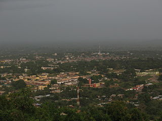
Ho is the capital city of the Ho Municipal District and the Volta Region of Ghana. The city lies between Mount Adaklu and Mount Galenukui or Togo Atakora Range, and is home to the Volta Regional Museum, a cathedral, and a prison. It was formerly the administrative capital of British Togoland now part of the Volta Region. The population of Ho Municipality according to the 2010 Population and Housing Census is 177,281 representing 8.4 percent of the region's total population. Females constitute 52.7 percent and males represent 47.3 percent. About 62 percent of the population resides in urban localities. The Municipality shares boundaries with Adaklu and Agotime-Ziope Districts to the South, Ho West District to the North and West and the Republic of Togo to the East. Its total land area is 2,361 square kilometers thus representing 11.5 percent of the region's total land area.

Lake Volta, the largest artificial reservoir in the world based on surface area, is contained behind the Akosombo Dam which generates a substantial amount of Ghana's electricity. It is completely within the country of Ghana and has a surface area of 8,502 square kilometres. It extends from Akosombo in the south to the northern part of the country.

The Eastern Region is located in south Ghana and is one of the sixteen administrative regions of Ghana. Eastern region is bordered to the east by the Lake Volta, to the north by Bono East Region and Ashanti region, to the west by Ashanti region, to the south by Central region and Greater Accra Region. Akans are the dominant inhabitants and natives of Eastern region and Akan, Ewe, Krobo, Hausa and English are the main spoken languages. The capital town of Eastern Region is Koforidua.The Eastern region is the location of the Akosombo dam and the economy of the Eastern region is dominated by its high-capacity electricity generation. Eastern region covers an area of 19,323 square kilometres, which is about 8.1% of Ghana's total landform.

Volta Region is one of Ghana's sixteen administrative regions, with Ho designated as its capital. It is located west of Republic of Togo and to the east of Lake Volta. Divided into 25 administrative districts, the region is multi-ethnic and multilingual, including groups such as the Ewe, the Guan, and the Akan peoples. The Guan peoples include the Lolobi, Likpe, Akpafu, Buem, and Nkonya people. This region was carved out of the Volta Region in December 2018 by the New Patriotic Party.
Atimpoku is a small town in the Eastern Region of Ghana and located along the Volta River. It is the capital of the Asuogyaman District, a district in the Eastern Region of Ghana.

Hohoe Municipal is one of the 25 administrative districts of the Volta Region of Ghana. It was carved out of the former Kpando District. It was established by the Legislative Instrument of 2012. The Municipality has a total land area of 1,172 km2, which is 5.6 per cent of the land area of the region. It shares borders with the Republic of Togo on the east, forming part of Ghana's international border; on the southeast by the Afadzato district and southwest by Kpando Municipality; on the north with Jasikan district; and on the northwest with the Biakoye districts. Its capital, Hohoe, is about 78 km from Ho, the regional capital and 220 km from Accra, the national capital. The population of Hohoe Municipality, according to the 2010 Population and Housing Census, is 167,016 representing 7.9 per cent of the total population of the Volta Region. It comprises 52.1 per cent females and 47.9 percent males.
Kpando is a town and capital of Kpando Municipal District in the northern Volta Region of Ghana. It is near the north eastern arm of Lake Volta and the Togo border. Kpando is the fifty-fourth most populous place in Ghana, in terms of population, with a population of 28,334 people. Kpando is connected by ferry and road to Gbefi, Hohoe, Ho and Dambai. It is about a 4-hour journey from Accra. The Kpando Municipality is a district in the Volta Region, and one of the oldest administrative districts in Ghana.

South Dayi is one of the constituencies represented in the Parliament of Ghana. It elects one Member of Parliament (MP) by the first past the post system of election. South Dayi is located in the South Dayi district of the Volta Region of Ghana.
Ho West is one of the constituencies represented in the Parliament of Ghana. It elects one Member of Parliament (MP) by the first past the post system of election. Ho West is located is in the Ho West District of the Volta Region of Ghana. Its capital is Dzolokpuita.
Ketu North is one of the constituencies represented in the Parliament of Ghana. It elects one Member of Parliament (MP) by the first past the post system of election. Ketu North is located in the Ketu district of the Volta Region of Ghana.
Ketu South is one of the constituencies represented in the Parliament of Ghana. It elects one Member of Parliament (MP) by the first past the post system of election. Ketu South is located in the Ketu district of the Volta Region of Ghana.

The Biakoye constituency is one of the constituencies represented in the Parliament of Ghana. It elects one Member of Parliament (MP) by the first past the post system of election. It is located in the Biakoye district of the Oti Region of Ghana.
Yapei or Yape is a small town in the Central Gonja District, a district in the Savannah Region of north Ghana.
Afadjato South is one of the constituencies represented in the Parliament of Ghana. It elects one Member of Parliament (MP) by the first past the post system of election. Afadjato South is located in the Afadzato South district of the Volta Region of Ghana. It was created in 2012 by the Electoral Commission of Ghana prior to the Ghanaian general election.

Western Togoland is an unrecognised state which is internationally recognised by the international community as a part of Ghana. It claims five of the Volta and Oti Regions. In 25 September 2020 separatists in Western Togoland declared independence from the Republic of Ghana. Western Togoland has been a member state of the Unrepresented Nations and Peoples Organization (UNPO) since 2017.
The Ayimagonu Festival is an annual festival celebrated by the chiefs and people of Dofor Traditional Area in the North Tongu District. It is located at a few kilometers east of Juapong in the Volta Region of Ghana. It is usually celebrated in the month of November.

The Western Togoland Rebellion is an ongoing separatist revolt led by the Ewe nationalist organization Western Togoland Restoration Front against the government of Ghana. The group seeks the independence of former British Togoland.
