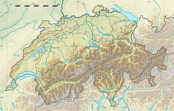
Location of Jungfrau-Aletsch protected area in Switzerland
The Jungfrau-Aletschprotected area (officially Swiss Alps Jungfrau-Aletsch) is located in south-western Switzerland between the cantons of Bern and Valais. It is a mountainous region in the easternmost side of the Bernese Alps, containing the northern wall of Jungfrau and Eiger, and the largest glaciated area in western Eurasia, comprising the Aletsch Glacier. The Jungfrau-Aletsch protected area is the first World Natural Heritage site in the Alps; it was inscribed in 2001.[1]
The summit ridge separating the cantons of Valais and Bern is the main watershed of Europe. The principal valleys on the north side run due north below the precipitous 20 kilometer north wall of the Jungfrau, Mönch and Eiger, thence to the Aar, a tributary of the Rhine which runs into the North Sea. The southern valleys drain into the southwest running valley of the Rhone which flows into the Mediterranean sea.
The climate of the region is strongly influenced by the height of the mountains. They form a barrier between the wet sub-oceanic climate of the north and the drier climate of the south-facing Valais slopes. On the north side the rainfall exceeds 2,200mm, most falling in summer, but on the south side it is only 1,000mm, with more falling in winter. The Valais experiences a subcontinental climate at low and medium altitudes and is markedly semi-arid. Mean annual temperatures range from -8.5°C at Jungfraujoch (3,500m) to 9.1°C at Brig (700m).
Physical features
Aletsch Glacier
The Jungfrau-Aletsch site is almost untouched, except for trails and mountain huts. It is deeply glaciated. About half of the area is higher than 2,600 metres, a few hundred metres lower than the limit between the glaciers accumulation and ablation zones. The total area covered by glacier is 35,000ha, it constitutes the largest continuous area of ice in the Alps. The largest and longest glacier in the Alps, the Aletsch Glacier is 23km long and has a maximum thickness of 900 metres at Konkordiaplatz.
Area
The protected site covers an area of 82,388ha, comprising the 53,888ha existing World Heritage Site plus extensions at both ends totaling 28,500ha. 56% is within the Canton of Valais, 44% within the Canton of Bern.
Flora and fauna
Tree line of the Aletsch Forest (Pro Natura nature centre).
Glaciers and barren rock constitute 80% of the area; 6% is forested, 5.2% is alpine meadow, and 8% is scrub. Altitude is the strongest factor influencing the distribution and diversity of the vegetation. Within the nominated area there are 1,800 species of vascular plants and 700 mosses. The growing period decreases with altitude, but there are 529 species of phanerogams and pteridophytes above the tree line. Broadleaf montane forest extends from 900m to 1,300m on north- facing slopes. On south-facing slopes the same zone is approximately 200m higher. The subalpine zone lies between 1,300m to 2,000m, between the broadleaf and alpine zone. Characteristic species are the Swiss Pine (Pinus Cembra) and the Norway Spruce (Picea abies) on the north and south side respectively. An example of Pinus cembra forest is the Aletsch Forest above the Aletsch Glacier and near the tree line. It developed on the moraine of the glacier after its maximum extension in 1850. The zone directly above the tree line forms a girdle of moorland vegetation and Alpine grassland.
1,250 fauna species have been recorded on the site, including 271 vertebrates: 42 mammals, 99 birds, eight reptiles, four amphibians and seven fish, and numerous invertebrates including 97 molluscs and 979 insects. As for the rest of the Alps, common species are the chamois (Rupicapra rupicapra), alpine ibex (Capra ibex), red deer (Cervus elaphus). Smaller mammals include the mountain hare (Lepus timidus), fox (Vulpes vulpes), ermine (Mustela erminea), marmot (Marmota marmota) and the reintroduced lynx (Felis lynx).
Tourism
Jungfraujoch
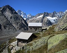
The regions of the Bernese Oberland and Valais have been popular tourist destinations since the 19th century. The Jungfrau was first climbed in 1811 and the Finsteraarhorn in 1812. The first tourists came mostly in summer, but in the 1930s winter sports became also popular. On the north side visitors are only able to visit the site via the Jungfrau railway which leads to the Jungfraujoch. The railway has turned the site from an inaccessible mountain face to a very accessible site visited by large nearby populations. The Jungfrau railway was built between 1870 and 1912, taking visitors from Kleine Scheidegg (2,061m) to Jungfraujoch (3,454m), the saddle between the Mönch and Jungfrau. On the south side the area of Riederalp-Bettmeralp hosts most of the visitors. Other inhabited regions on the margin are Kandersteg and the Lötschental. The network of foot-paths is well developed around the site but nonexistent through it, the centre being inaccessible to walkers. The site can only be accessed by experienced mountaineers and there is a series of 37 shelters and five mountain refuges with a total of 1,582 beds, managed by the Swiss Alpine Club. The Aletsch ecological centre in Riederalp is run by Pro Natura functions as a visitor center.
History
1933: The protection of the Aletsch forest is assumed by the canton of Valais
1960: The canton of Bern assumes the protection of the upper Lauterbrunnen Valley
The Alpine region of Switzerland, conventionally referred to as the Swiss Alps, represents a major natural feature of the country and is, along with the Swiss Plateau and the Swiss portion of the Jura Mountains, one of its three main physiographic regions. The Swiss Alps extend over both the Western Alps and the Eastern Alps, encompassing an area sometimes called Central Alps. While the northern ranges from the Bernese Alps to the Appenzell Alps are entirely in Switzerland, the southern ranges from the Mont Blanc massif to the Bernina massif are shared with other countries such as France, Italy, Austria and Liechtenstein.
The Bernese Alps are a mountain range of the Alps, located in western Switzerland. Although the name suggests that they are located in the Berner Oberland region of the canton of Bern, portions of the Bernese Alps are in the adjacent cantons of Valais, Fribourg and Vaud, the latter being usually named Fribourg Alps and Vaud Alps respectively. The highest mountain in the range, the Finsteraarhorn, is also the highest point in the canton of Bern.
The Jungfrau, at 4,158 meters (13,642 ft) is one of the main summits of the Bernese Alps, located between the northern canton of Bern and the southern canton of Valais, halfway between Interlaken and Fiesch. Together with the Eiger and Mönch, the Jungfrau forms a massive wall of mountains overlooking the Bernese Oberland and the Swiss Plateau, one of the most distinctive sights of the Swiss Alps.
The Aletsch Glacier or Great Aletsch Glacier is the largest glacier in the Alps. It has a length of about 23 km (14 mi) (2014), a volume of 15.4 km3 (3.7 cu mi) (2011), and covers about 81.7 km2 (2011) in the eastern Bernese Alps in the Swiss canton of Valais. The Aletsch Glacier is composed of four smaller glaciers converging at Konkordiaplatz, where its thickness was measured by the ETH to be still near 1 km (3,300 ft). It then continues towards the Rhône valley before giving birth to the Massa. The Aletsch Glacier is – like most glaciers in the world today – a retreating glacier. As of 2016, since 1980 it lost 1.3 kilometres (0.81 mi) of its length, since 1870 3.2 kilometres (2.0 mi), and lost also more than 300 metres (980 ft) of its thickness.
The Eiger is a 3,967-metre (13,015 ft) mountain of the Bernese Alps, overlooking Grindelwald and Lauterbrunnen in the Bernese Oberland of Switzerland, just north of the main watershed and border with Valais. It is the easternmost peak of a ridge crest that extends across the Mönch to the Jungfrau at 4,158 m (13,642 ft), constituting one of the most emblematic sights of the Swiss Alps. While the northern side of the mountain rises more than 3,000 m (10,000 ft) above the two valleys of Grindelwald and Lauterbrunnen, the southern side faces the large glaciers of the Jungfrau-Aletsch area, the most glaciated region in the Alps. The most notable feature of the Eiger is its nearly 1,800-metre-high (5,900 ft) north face of rock and ice, named Eiger-Nordwand, Eigerwand or just Nordwand, which is the biggest north face in the Alps. This huge face towers over the resort of Kleine Scheidegg at its base, on the eponymous pass connecting the two valleys.
The Finsteraarhorn is a mountain lying on the border between the cantons of Bern and Valais. It is the highest mountain of the Bernese Alps and the most prominent peak of Switzerland. The Finsteraarhorn is the ninth-highest mountain and third-most prominent peak in the Alps. In 2001 the whole massif and surrounding glaciers were designated as part of the Jungfrau-Aletsch World Heritage Site.
The Mönch at 4,110 metres (13,480 ft) is a mountain in the Bernese Alps, in Switzerland. Together with the Eiger and the Jungfrau, it forms a highly recognisable group of mountains, visible from far away.
The Kleine Scheidegg is a mountain pass at an elevation of 2,061 m (6,762 ft), situated below and between the Eiger and Lauberhorn peaks in the Bernese Oberland region of Switzerland. The name means "minor watershed", as it only divides the two arms of the Lütschine river, both converging at Zweilütschinen, while the nearby Grosse Scheidegg divides the Lütschine from the Rychenbach stream.
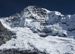
The Jungfraujoch is a saddle connecting two major 4000ers of the Bernese Alps: the Jungfrau and the Mönch. It lies at an elevation of 3,463 metres (11,362 ft) above sea level and is directly overlooked by the rocky prominence of the Sphinx. The Jungfraujoch is a glacier saddle, on the upper snows of the Aletsch Glacier, and part of the Jungfrau-Aletsch area, situated on the boundary between the cantons of Bern and Valais, halfway between Interlaken and Fiesch.
The Aletschhorn is a mountain in the Alps in Switzerland, lying within the Jungfrau-Aletsch region, which has been designated a World Heritage Site by UNESCO. The mountain shares part of its name with the Aletsch Glacier lying at its foot.
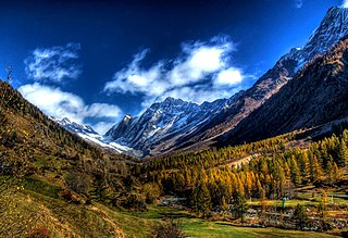
The Lötschental is the largest valley on the northern side of the Rhône valley in the canton of Valais in Switzerland. It lies in the Bernese Alps, with the Lonza running down the length of the valley from its source within the Langgletscher.
Grosses Fiescherhorn is a mountain peak of the Bernese Alps, located on the border between the cantons of Bern and ValaisValais, halfway between the Mönch and the Finsteraarhorn. At 4,049 metres (13,284 ft) above sea level, its summit culminates over the whole Fiescherhorn massif, which is also composed of the slightly lower Hinteres Fiescherhorn to the south and Kleines Fiescherhorn to the east. From the north both are well hidden behind other mountain peaks and can only been seen from Isch in Grindelwald. The mountain is shared between the municipalities of Grindelwald and Fieschertal.
The Bernese Oberland, sometimes also known as the Bernese Highlands, is the highest and southernmost part of the canton of Bern. It is one of the canton's five administrative regions. It constitutes the Alpine region of the canton and the northern side of the Bernese Alps, including many of its highest peaks, among which the Finsteraarhorn, the highest in both range and canton.
The Bietschhorn is a mountain in canton Wallis to the south of the Bernese Alps in Switzerland. The northeast and southern slopes of the mountain are part of the Jungfrau-Aletsch Protected Area listed as a UNESCO World Heritage Site that also includes the Jungfrau and the Aletsch Glacier. The Bietschhorn is located on the south side of the Lötschental valley and form part of the UNESCO World Heritage Region at the north end of the Bietschtal valley and Baltschiedertal valley. Most climbers approach the mountain from either the Bietschhornhütte or the Baltschiederklause.
The Fiescher Glacier is a valley glacier on the south side of the Bernese Alps in the canton of Valais, Switzerland. 16 km (9.9 mi) in length, it is the second longest glacier in the Alps. The glacier covers an area of 33 km2 (13 sq mi).
The Eggishorn is a mountain in the southeastern part of the Bernese Alps, located north of Fiesch in the Swiss canton of Valais. A cable car station is located on a secondary summit named Fiescherhorli, 500 metres south of the main peak.
The Trugberg is a mountain in the Bernese Alps, located south of the Mönch in the canton of Valais, Switzerland. It is located above the Konkordiaplatz where the névé of the Jungfraufirn on the west side and the Ewigschneefeld on the east side converge to form the Aletsch Glacier. Debris accumulating on both sides of the mountain form one of the two important supraglacial moraines of the Aletsch Glacier.
Jungfraujoch is an underground railway station situated near the Jungfraujoch, in the canton of Valais, a few metres from the border with the canton of Bern. At 3,454 metres (11,332 ft) above sea level, it is the terminus of the Jungfrau Railway and the highest railway station in Switzerland and Europe. The Jungfrau Railway runs from Kleine Scheidegg in the Bernese Oberland, through the Jungfrau Tunnel and crosses the border between the two cantons shortly before the terminus.
The Mönchsjoch Hut is a mountain hut located in the Bernese Alps in the canton of Valais in Switzerland. At an altitude of 3,658 metres (12,001 ft) it is the highest staffed hut in Switzerland.
The Finsteraarhorn Hut is a mountain hut of the Swiss Alpine Club, located north of Fieschertal in the canton of Valais. It lies at a height of 3,048 metres (10,000 ft) above sea level at the southern foot of the Finsteraarhorn, the highest peak of the Bernese Alps. The hut overlooks the upper basin of the Fiescher Glacier, which is among the largest of the range. It is located a few kilometres east of the Grünhornlücke.
This page is based on this Wikipedia article Text is available under the CC BY-SA 4.0 license; additional terms may apply. Images, videos and audio are available under their respective licenses.