Kachin Hills

Last updated
Kachin Hills
Myanmar relief location map.jpg
Red triangle with thick white border.svg
Kachin Hills
Highest point
Peak Bumhpa Bum
Elevation 3,411 m (11,191 ft)
Coordinates 26°41′N97°14′E / 26.683°N 97.233°E / 26.683; 97.233
Geography
Country Burma
Region Southeast Asia
Borders onBurma, Arunachal Pradesh (India),
Tibet and Yunnan (China)
Geology
Type of rock Granite, limestone

The Kachin Hills are a heavily forested group of highlands in the extreme northeastern area of the Kachin State of Burma. It consists of a series of ranges running mostly in a N/S direction, including the Kumon Bum subrange of which the highest peak is Bumhpa Bum with an elevation of 3,411 metres (11,191 ft) [1] one of the ultra prominent peaks of Southeast Asia.

Contents

Geography

The country within the Kachin hill tracts is roughly estimated at 19,177 square miles (49,670 km2), and consists of a series of ranges, for the most part running north and south, and intersected by valleys, all leading towards the Ayeyarwady River, which drains the whole country.

Kachin people

The Kachin Hills are inhabited by the Kachin or Chingpaw, who are known on the Assam frontier as Singphos and on the Chinese frontier as Jingpos. Owing to the great number of tribes, sub-tribes and clans of the Kachins, the part of the Kachin hills which has been taken under administration in the Myitkyina and Bhamo districts was divided into 40 hill tracts (since reduced to five). Beyond these tracts, there are many Kachins in Katha, Mong Mit and the northern Shan States.

There were 64,405 Kachins enumerated at the census of 1901.

In the middle of the 19th century, the southern limit of the Kachins was 200 mi. farther north than it is now. Since then the ethnic group has been drifting steadily southward and eastward, a vast aggregate of small independent clans united by no common government, but all obeying a common impulse to move outwards from their original seats along the line of least resistance. Now the Kachins are on both sides of the border of upper Burma, and are a force to be reckoned with by frontier administrators.

British administration

According to the Kachin Hill Tribes Regulation of 1895, administrative responsibility was accepted by the British government on the left bank of the Irrawaddy for the country south of the Nmaikha, and on the right bank for the country south of a line drawn from the confluence of the Malikha and Nmaikha through the northern limit of the Laban district and including the jade mines. The tribes north of this line were told that if they abstained from raiding to the south of it they would not be interfered with. South of that line peace was to be enforced and a small tribute exacted, with a minimum of interference in-their private affairs.

On the British side of the border, the chief objects of Britain's colonial policy were the disarmament of the tribes and construction of frontier and internal roads. A light tribute was exacted. The Kachins have been the object of many police operations and two regular expeditions:

(I) Expedition of 1892-93

Bhamo was occupied by the British on December 28, 1885, and almost immediately, trouble began. Constant punitive measures were carried on by the military police; but in December 1892, a police column proceeding to establish a post at Sima was heavily attacked, and simultaneously the town of Myitkyina was raided by Kachins. A force of 1,200 troops was sent to put down the uprising. The enemy received their final blow at Palap, but not before three officers were killed, three wounded and 102 sepoys and followers killed and wounded.

(II) Expedition of 1895-96

The continued misconduct of the Sana Kachins from beyond the administrative border rendered punitive measures necessary in the eyes of British colonialists. No retaliation had taken place since the attack on Myitkyina in December 1892. Now two columns were sent up, one of 250 rifles from Myitkyina, the other of 200 rifles from Mogaung, marching in December 1895. The resistance was insignificant, and the operations were completely successful. A strong force of military police was stationed at Myitkyina, with several outposts in the Kachin hills.

Pianma Incident

In 1910, during the very last year of Qing Empire, the British occupied Hpimaw [2] (Pianma) [3] in the Pianma Incident , as well as a part of what is now Northern Kachin state in 1926-27 and part of the Wa states in 1940. [4] [5]

Independent Burma

Map showing the areas ceded from Burma to China, including Hpimaw, Gawlam & Kangfang Burma-China border map.jpg
Map showing the areas ceded from Burma to China, including Hpimaw, Gawlam & Kangfang

Burma relinquished [2] [6] the eastern villages of Hpimaw (Pianma) and adjacent Gawlam (Gulang) [7] and Kangfang (Gangfang) [8] to the People's Republic of China (PRC) in 1960, ending the political boundary dispute. Although Kachin Hills had been granted much autonomy under the 1947 constitution, the Burmese government has since integrated it into the rest of the country.

See also

Related Research Articles

Jingpo or Kachin is a Tibeto-Burman language of the Sal branch spoken primarily in Kachin State, Myanmar; Northeast India; and Yunnan, China. The Jingpo peoples, a confederation of several ethnic groups who live in the Kachin Hills, are the primary speakers of Jingpo language, numbering approximately 1,000,000 speakers. The term "Kachin language" may refer to the Jingpo language or any of the other languages spoken by the Jingpo peoples, such as Lisu, Lashi, Rawang, Zaiwa, Lhao Vo, and Achang. These languages are from distinct branches of the highest level of the Tibeto-Burman family.

<span class="mw-page-title-main">Bit language</span> Austroasiatic language spoken in Laos and China

Bit is an Austroasiatic language spoken by around 2,000 people in Phongsaly Province, northern Laos and in Mengla County, Yunnan, China.

<span class="mw-page-title-main">Lushui</span> County-level city in Yunnan, China

Lushui is a county-level city in and the seat of Nujiang Prefecture, western Yunnan Province, China. It borders Myanmar's Kachin State to the west and occupies the southern fifth of Nujiang Prefecture.

<span class="mw-page-title-main">Guangnan County</span> County in Yunnan, China

Guangnan County is located in Wenshan Zhuang and Miao Autonomous Prefecture, Yunnan province, China. The seat of Guangnan, known today as Liancheng (莲城镇), was the heart of the Gouding Kingdom (句町) that lasted approximately 400 years, from 111 BC to 316 AD.

<span class="mw-page-title-main">Malipo County</span> County in Yunnan, China

Malipo County is under the administration of the Wenshan Zhuang and Miao Autonomous Prefecture, in the southeast of Yunnan province, China, bordering Ha Giang Province to the southeast.

Paha or Baha is a Kra language spoken in northern Guangnan County, Wenshan Prefecture, Yunnan. The two villages are located near the border with Longlin County, Guangxi. Paha is often considered to be part of the Buyang dialect cluster and is the most divergent form. Although listed in Ethnologue as Baha Buyang, Weera Ostapirat classifies Paha separately from the other Buyang varieties.

Mảng is an Austroasiatic language of Vietnam, China, and Laos. It is spoken mainly in Lai Châu Province, Vietnam and across the border in Jinping County, China. It was first documented only in 1974.

The Nisoish or Yi languages, which contains both the Northern Loloish and Southeastern Loloish branches, are a branch of the Loloish languages proposed by Lama (2012). Northern Loloish and Southeastern Loloish were established by Bradley (1997), while the Nisoish group combining Bradley's two branches was proposed by Ziwo Lama (2012). Lama (2012) refers to Northern Loloish as Nisoid or Nisu–Lope, and Southeastern Loloish as Axi–Puoid.

Lhao Vo, also known as Maru (မရူ) and Langsu, is a Burmish language spoken in Burma and by a few thousand speakers in China.

Blang (Pulang) is the language of the Blang people of China and Myanmar.

<span class="mw-page-title-main">Min Zhuang language</span> Tai language spoken in Yunnan, China

Min Zhuang is a recently described Tai language spoken in the Langheng (郎恒) area of Funing County, Yunnan, China, and possibly also southwestern Guangxi province. All speakers are reportedly bilingual in Yei Zhuang, which is classified as Northern Tai. The language was first described in 2011 by Eric C. Johnson of SIL International, though it had been earlier mentioned in Kullavanijaya and L-Thongkum (1998).

Pela or Bola, is a Burmish language of Western Yunnan, China. In China, Pela speakers are classified as part of the Jingpo ethnic group. Pela may also be spoken in Burma.

Bisu is a Loloish language of Thailand, with a couple thousand speakers in China. Varieties are Bisu proper (Mbisu) and Laomian (Guba), considered by Pelkey to be distinct languages.

Muangphe is a Lolo-Burmese language spoken by about 300 people in Guangnan County, Yunnan, China.

Chashan is a Burmish language spoken in Pianma Township (片马镇), Lushui County, Yunnan, China, in Xiapianma (下片马), Gangfang (岗房), and Gulang (古浪) villages. It is closely related to Lashi, and has 56.3% lexical similarity with Lashi of Lushui County out of a sample of 1,000 vocabulary words.

Woni is a Southern Loloish language spoken in Zhenyuan Yi, Hani and Lahu Autonomous County and Xinping Yi and Dai Autonomous County of Yunnan, China. The most extensive description of Woni to date is that of Yang (2016).

<span class="mw-page-title-main">China–Myanmar border</span> International border

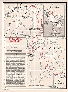
The China–Myanmar border is the international border between the territory of the People's Republic of China and Myanmar. The border is 2,129 km (1,323 mi) in length and runs from the tripoint with India in the north to the tripoint with Laos in the south.

<span class="mw-page-title-main">Jiangxinpo</span>

Jiangxinpo was an area currently in Kachin State, Myanmar, located between the N'Mai and Mali Rivers, west of the Gaoligong Mountains of Yunnan, China. It was previously under the rule of the Qing dynasty of China.

Long or Nong is an unclassified Loloish language of Huaning County, Yunnan, China. It is also called Luowu 罗婺.

The Pianma Incident began in 1910, from a dispute in the Pianma Kachin Chiefdom under Qing China suzerainty, between Pianma's Tusi and other local leaders, and the subsequent British Burman occupation of the Qing Empire's territories.

References

  1. "Bumhpa Bum - Peakbagger.com". www.peakbagger.com.
  2. 1 2 "International Boundary Study No. 42 – Burma-China Boundary" (PDF). US DOS. 30 November 1964. Archived from the original (PDF) on 31 January 2020. Retrieved 17 September 2020.
  3. "Lúshuǐ Xiàn Piànmǎ Zhèn Piànmǎ Cūnwěihuì Xiàpiànmǎ Cūn" 泸水县片马镇片马村委会下片马村 [Xiapianma Village, Pianma Village Committee, Pianma Town, Lushui County]. ynszxc.gov.cn (in Chinese). Archived from the original on 2015-04-02.
  4. Gillogly, Kathleen (2006). "Transformations of Lisu Social Structure Under Opium Control and Watershed Conservation in Northern Thailand" (PDF). evols.library.manoa.hawaii.edu. Archived from the original (PDF) on 2013-09-21. Retrieved 2020-09-13.
  5. "Yunnan | province, China". Encyclopedia Britannica . Retrieved 2023-10-30. In 1910 the British, then established in Burma, induced the tusi of Pianma (Hpimau) to defect from the central Chinese government, and they then occupied his territory in northwestern Yunnan. Britain also forced China to give up a tract of territory in what is now the Kachin state of Myanmar (1926–27), as well as the territory in the Wa states (1940).
  6. "International Boundary Study No. 42 – Burma-China Boundary" (PDF). USDOS. 30 November 1964. Archived from the original (PDF) on 31 January 2020. Retrieved 17 September 2020. Agreement on the Question of the Boundary signed on January 28, 1960...(b) the villages of Hpimaw, Gawlum, and Kangfang would be Chinese;...(d) the Panhung-Panlao tribal area would be exchanged (for Namwan); and (e) with the exception of d, the 1941 boundary in the Wa states would be accepted...
  7. "Lúshuǐ Xiàn Piànmǎ Zhèn Gǔlàng Cūnwěihuì" 泸水县片马镇古浪村委会 [Gulang Village Committee, Pianma Town, Lushui County]. ynszxc.gov.cn (in Chinese). Archived from the original on 2015-04-03.
  8. "Lúshuǐ Xiàn Piànmǎ Zhèn Gǎngfáng Cūnwěihuì" 泸水县片马镇岗房村委会 [Gangfang Village Committee, Pianma Town, Lushui County]. ynszxc.gov.cn (in Chinese). Archived from the original on 2015-04-02.

Sources