Kakamega Forest

Last updated
View over Kakamega forest. Kakamega forest view.jpg
View over Kakamega forest.

Kakamega Forest is a tropical rainforest situated in the Kakamega and Nandi County of Kenya, northwest of the capital Nairobi, and near the border with Uganda. It is Kenya's only tropical rainforest and is said to be Kenya's last remnant of the ancient Guineo-Congolian rainforest that once spanned the continent.

Contents

Geography

The forest lies on undulating terrain, mostly between 1500 and 1600 meters elevation. It is in the watershed of the Isiukhu and Yala rivers, which originate on the Nandi Escarpment to the east and flow westwards through the forest before emptying into Lake Victoria. [1]

The forest including reserves encloses about 238 square kilometers, a little less than half of which currently remains as indigenous forest. In the north of the forest is the 4,468 hectares (45 km2; 17 sq mi) Kakamega National Reserve, given national forest reserve status in 1985. [2] Just to the north is the Kisere Forest Reserve. Throughout the forest are a series of grassy glades, ranging in size from about 1 to 50, with a few larger clearings. The origins of the glades are uncertain. Some are certainly recent clearings, but others predate recent records. These may have originated from past human activity such as cattle grazing or may be the result of herbivory and movements by large mammals such as buffalo and elephants (both now extirpated from the region). The glades vary a great deal in structure, some being open grass and others having a considerable number of trees or shrubs. A number of streams and small creeks run through the reserve. The larger creeks are usually bordered by a few to tens of meters of forest on either side which divide the glades, while the smallest creeks flow through open grasslands, often forming small marshy patches.

Climate

Kakamega Rainforest, hidden deep within the dark blue, Af (Tropical, rainforest) splotch in the western portion of this Koppen-Geiger climate classification map map, The rainforest lies in Southeastern Kakamega county, Western Nandi county, and Northern Vihiga county, although the entire region has a tropical rainforest climate, despite not being part of the national park. Koppen-Geiger Map KEN present.svg
Kakamega Rainforest, hidden deep within the dark blue, Af (Tropical, rainforest) splotch in the western portion of this Köppen-Geiger climate classification map map, The rainforest lies in Southeastern Kakamega county, Western Nandi county, and Northern Vihiga county, although the entire region has a tropical rainforest climate, despite not being part of the national park.

Köppen climate classification map for Kenya for 1980–2016 The Kakamega Forest is very wet, with an average of 1200 mm – 1700 mm of rain per year. Rainfall is heaviest in April and May ("long rains"), with a slightly drier June and a second peak roughly in August to September ("short rains"). January and February are the driest months. Temperature is fairly constant throughout the year, ranging between 20°C - 30°C. [3]

Biodiversity

Blue monkey climbing in tree at Kakamega Rain Forest. MonkeyAtKagamega.JPG
Blue monkey climbing in tree at Kakamega Rain Forest.

The forest lies in the Victoria Basin forest-savanna mosaic ecoregion. The forest's flora and fauna include many species associated with the moist forests of the Guineo-Congolian region, which lie further west in the basin of the Congo River. [4]

Flora found in the park include some of Africa's greatest hard and soft woods: Elgon teak (Olea welwitschii), red stinkwood (Prunus africana), white stinkwood, several varieties of croton, and Aningeria altissima . There are 380 recorded species of plants. This includes 60 species of ferns, 150 species of trees and shrubs, and 170 species of flowering plants including 60 species of orchids with 9 species found only in this forest.

The forest is famous for its birds. 367 [5] [6] bird species have been recorded in the forest such as the west African Great blue turaco and black-and-white-casqued hornbill. At least 9 birds are not found anywhere else. [7]

Mammals that occur in the park include bush pig, duikers, bushbuck, African clawless otter, mongoose, giant African water shrew, squirrels, tree pangolin, porcupine, bats and a variety of primates including the blue monkey, redtail monkey, De Brazza's monkey, baboon, potto and the occasional vervet monkey. Leopards have been occasionally reported, but the last official sighting was in 1991. [8]

Amphibians and reptiles are also found in Kakamega Forest.

Insects are abundant and some are quite spectacular, such as Goliath beetles, pink and green flower mantis, and numerous colorful butterflies (489 species). Particularly well represented groups are ants (Formicidae), Lepidopterans, Orthopterans, and beetles. Gastropods, millipedes and spiders are also common.

The flora and fauna of Kakamega Forest has not been extensively studied.

Conservation

Kakamega forest map2.svg

Kakamega Forest Reserve was designated in 1933. It currently has an area of 178.38 km2. [9] In 1967 the Isecheno and Yala or Lirhanda nature reserves were established within the forest reserve. Kakamega National Reserve was designated in 1985, composed of the northern portion of the Kakamega Forest Reserve and the Kisere Forest Reserve to the north. [10] It has an area of 44.7 km2. [11]

Many local inhabitants rely on the forest to supply important resources, such as firewood, building poles and traditional medicines. Cattle grazing occurs in some of the glades. The region is said to be one of the most densely populated rural areas in the world, and pressure on the forest resources is considerable. The German funded project BIOTA East worked in the forest from 2001 until 2010, creating forest inventories for many life forms and aiming to find strategies for a sustainable use of the forest.

Tourism

The Southern part of Kakamega forest, Isecheno Forest station run by the Kenya Forest Service is the most accessible in Tourism. There is the well known Mama Mtere tree, a historic tree and the most photographed tree in Kakamega forest, there are also strangler fig trees. [12] [13]

There are hiking trails in the forest that allow for forest walking, camping, hiking, primate watching, bird and butterfly watching, game watching and village walks. The Kakamega Rainforest Tour Guides (KRFTG) can arrange tours to visit the weeping stone (Crying stone) at Ilesi, located along the Kakamega-Kisumu road, or Kisere Forest to see the De-brazes monkey in the north of Kakamega. Also bird watching, morning 6:30 am – 8:30 am is fantastic walk or evening 4:30 pm – 6:30 pm. [14]

Forest tours have attracted prominent personalities including outgoing US Ambassador to Kenya Robert Godec who paid a visit in April 2018 and marveled at its beauty. [15]

Related Research Articles

<span class="mw-page-title-main">Afrotropical realm</span> One of Earths eight biogeographic realms

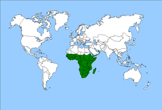
The Afrotropical realm is one of the Earth's eight biogeographic realms. It includes Sub-Saharan Africa, the southern Arabian Peninsula, the island of Madagascar, and the islands of the western Indian Ocean. It was formerly known as the Ethiopian Zone or Ethiopian Region.

<span class="mw-page-title-main">Kakamega</span> Town in Kakamega County, Kenya

Kakamega is a town in western Kenya lying about 30 km north of the Equator. It is the headquarters of Kakamega County that has a population of 1,867,579. The town has an urban population of 107,227.

<span class="mw-page-title-main">Bwindi Impenetrable National Park</span> National park in Uganda

The Bwindi Impenetrable National Park is a national park in southwestern Uganda. It is part of the Bwindi Impenetrable Forest and is situated along the Democratic Republic of the Congo border next to the Virunga National Park and on the edge of the Albertine Rift. Composed of 321 km2 (124 sq mi) of both montane and lowland forest, it is accessible only on foot. It is a United Nations Educational, Scientific and Cultural Organization-designated World Heritage Site.

<span class="mw-page-title-main">Northern Congolian forest–savanna mosaic</span> Forest and savanna ecoregion of Central Africa

The Northern Congolian forest–savanna mosaic is a forest and savanna ecoregion of central Africa. It extends east and west across central Africa, covering parts of Cameroon, Central African Republic, Democratic Republic of the Congo, South Sudan, and Uganda. It is part of the belt of transitional forest-savanna mosaic that lie between Africa's moist equatorial Guineo-Congolian forests and the tropical dry forests, savannas, and grasslands to the north and south.

<span class="mw-page-title-main">Wildlife of Burundi</span> Flora and fauna in Burundi

The wildlife of Burundi is composed of its flora and fauna. The small, landlocked country is home to 2,950 species of plants, 596 birds, 163 species of mammals, 52 species of reptiles, 56 species of amphibians, and 215 fish species. The wildlife has been drastically reduced in recent years, mainly on account of intense population pressure, conversion of large areas of forest into agricultural land, and extensive livestock farming. The protected area encompasses little more than 5% of the total area of the country.

<span class="mw-page-title-main">Wildlife of Cameroon</span>

The wildlife of Cameroon is composed of its flora and fauna. Bordering Nigeria, it is considered one of the wettest parts of Africa and records Africa's second highest concentration of biodiversity. To preserve its wildlife, Cameroon has more than 20 protected reserves comprising national parks, zoos, forest reserves and sanctuaries. The protected areas were first created in the northern region under the colonial administration in 1932; the first two reserves established were Mozogo Gokoro Reserve and the Bénoué Reserve, which was followed by the Waza Reserve on 24 March 1934. The coverage of reserves was initially about 4 percent of the country's area, rising to 12 percent; the administration proposes to cover 30 percent of the land area.

<span class="mw-page-title-main">Wildlife of Uganda</span> Endemic flora and fauna

The wildlife of Uganda is composed of its flora and fauna. Uganda has a wide variety of different habitats, including mountains, hills, tropical rainforest, woodland, freshwater lakes, swamps and savanna with scattered clumps of trees. The country has a biodiverse flora and fauna reflecting this range of habitats and is known for its primates, including gorillas and chimpanzees. There are ten national parks and thirteen wildlife reserves; some 345 species of mammal and 1020 species of bird have been recorded in the country.

<span class="mw-page-title-main">Trifinio Fraternidad Transboundary Biosphere Reserve</span> Protected area in El Salvador, Guatemala, and Honduras

The Trifinio Fraternidad Transboundary Biosphere Reserve is a transboundary protected area located where the borders of El Salvador, Guatemala and Honduras meet. It protects the Montecristo massif and its cloud forests across the three countries' borders.

<span class="mw-page-title-main">East African montane forests</span>

The East African montane forests is a montane tropical moist forest ecoregion of eastern Africa. The ecoregion comprises several separate areas above 2000 meters in the mountains of South Sudan, Uganda, Kenya, and Tanzania.

<span class="mw-page-title-main">Northern Zanzibar–Inhambane coastal forest mosaic</span> Tropical forest ecoregion of East Africa

Northern Zanzibar–Inhambane coastal forest mosaic, also known as the Northern Swahili coastal forests and woodlands, is a tropical moist broadleaf forest ecoregion of coastal East Africa. The ecoregion includes a variety of habitats, including forest, savanna and swamps.

Phyllonorycter achilleus is a moth of the family Gracillariidae. It is found in the Albertine Rift and the Kakamega Forest in western Kenya. The habitat consists of tropical rainforests where Guineo-Congolian flora intermixes with savannah plants at altitudes above 1,500 meters.

<span class="mw-page-title-main">Mwea National Reserve</span>

The Mwea National Reserve is a nature reserve in Kenya. Its altitude ranges between 1,000 and 1,100 m, dominated by the Acacia-Commiphora bushland on the north shore of Kamburu Reservoir, at the confluence of Tana and Thiba Rivers. The other vegetation is mixed among the scattered large trees, typical savannah ecosystem. Open grasslands are dominant along the main rivers, with occasional thick undergrowth, as well as a riparian or riverine woodland.

<span class="mw-page-title-main">Kahuzi-Biéga National Park</span> National park in the Democratic Republic of the Congo

The Kahuzi-Biega National Park is a protected area near Bukavu town in eastern Democratic Republic of the Congo. It is situated near the western bank of Lake Kivu and the Rwandan border. Established in 1970 by the Belgian photographer and conservationist Adrien Deschryver, the park is named after two dormant volcanoes, Mount Kahuzi and Mount Biega, which are within its limits. With an area of 6,000 square kilometres (2,300 sq mi), Kahuzi-Biega is one of the biggest national parks in the country. Set in both mountainous and lowland terrain, it is one of the last refuges of the rare species of Eastern lowland gorilla, an endangered category under the IUCN Red List. The park is a UNESCO World Heritage Site, inscribed in 1980 for its unique biodiversity of rainforest habitat and its eastern lowland gorillas. In 1997, it was listed on the List of World Heritage in Danger because of the political instability of the region, an influx of refugees, and increasing wildlife exploitation.

<span class="mw-page-title-main">Southern Congolian forest–savanna mosaic</span>

The southern Congolian forest–savanna mosaic is an ecoregion that covers a large area of the southern Democratic Republic of the Congo and northeastern Angola. Its rich blend of habitats provides key insights into the biogeography of central Africa with the extensive climatic variation that it has been experiencing for the last 10 million years. The human population is not high.

<span class="mw-page-title-main">Chirinda Forest Botanical Reserve</span>

The 950 hectares Chirinda Forest Botanical Reserve is situated on the slopes of Mount Selinda, 30 km south of Chipinge, in the Chipinge Highlands of Manicaland, Zimbabwe, and is administered by the Forestry Commission. The reserve is situated at between 900 and 1,200 m in altitude, and receives some 1,370 mm (54 in) to 1,466 mm (57.7 in) of annual rainfall. 606 hectares of its higher levels, above 1,076 m (3,530 ft), is covered by moist evergreen forest, specifically Zanzibar-Inhambane transitional rain forest, of which it represents the southernmost occurrence. The headwaters of three streams, namely the Zona, Chinyika and Musangazi, drain the two broad highlands which it encloses. The boundaries of the reserve are not strictly enforced, so that cattle grazing and plant harvesting are ongoing. The reserve is surrounded by communal settlements, commercial timber plantations and small-scale commercial farming units. The naturalist Charles Swynnerton was appointed manager of the nearby Gungunyana farm in 1900, and a number of plant, bird and insect names commemorate his collecting activities of the next two decades. Chirinda means "lookout" or "vantage point" in the chiNdau language, or perhaps "place of refuge".

<span class="mw-page-title-main">Northeastern Congolian lowland forests</span>

The Northeastern Congolian lowland forests is a tropical moist broadleaf forest ecoregion that spans the Democratic Republic of the Congo and the Central African Republic.

The Guineo-Congolian region is a biogeographical region in Africa straddling the Equator and stretching from the Atlantic Ocean through the Congo Basin to the Congo / Nile divide in Rwanda and Burundi. Formerly, this region was largely covered in rain forest, on both well-drained sites and in swamp forests, but little undisturbed primary forest now remains, having been replaced in many areas by savanna and secondary-growth forest.

<span class="mw-page-title-main">Victoria Basin forest–savanna mosaic</span>

The Victoria Basin forest–grassland mosaic is an ecoregion that lies mostly in Uganda and extends into neighboring countries. The ecoregion is centered north and west of Lake Victoria, with an outlier on the border of Ethiopia and South Sudan.

The Nandi Escarpment is an escarpment in Nandi County, Kenya. It marks the boundary between Kisumu and Nandi counties. It consists of numerous massive geological rocks ,one being Nandi rock. Monkeys and baboons are among common wildlife sightings.

<span class="mw-page-title-main">Nahá–Metzabok</span>

Nahá–Metzabok Biosphere Reserve is a biosphere reserve in southeastern Mexico. It is located in the state of Chiapas, on the northeastern flank of the Chiapas Highlands. The reserve protects montane rain forests, pine and oak forests, and natural lakes.

References

  1. "The Kakamega Forest". Unesco World Heritage Centre. Accessed 15 March 2020. https://whc.unesco.org/en/tentativelists/5508/
  2. World Database on Protected Areas – Kakamega Forest
  3. KWS "Kakamega National Reserve" Archived 2013-07-07 at the Wayback Machine KWS Website
  4. Burgess, Neil et al. (2004). Terrestrial Ecoregions of Africa and Madagascar. Island Press, 2004. pp. 291-292
  5. Udo M. Savalli, "Flora and fauna in Kakamega Forest", University of Kentucky
  6. Udo M. Savalli, "List of birds in Kakamega Forest", University of Kentucky
  7. Wildize.org "Treasures of the Forest" Powerpoint Slide
  8. Harold Ayodo, "Kakamega forest may be wiped out in 20 years" The Standard newspaper, April 8th 2010
  9. UNEP-WCMC (2023). Protected Area Profile for Kakamega Forest Reserve from the World Database on Protected Areas. Retrieved 28 November 2023.
  10. BirdLife International (2023). Important Bird Area factsheet: Kakamega forest. Retrieved 28 November 2023.
  11. UNEP-WCMC (2023). Protected Area Profile for Kakamega National Reserve from the World Database on Protected Areas. Retrieved 28 November 2023.
  12. "Kakamega Forest is Faced with Demise". 18 March 2016.
  13. "Kakamega forest that is home to variety of species". 25 December 2020.
  14. "Kakamega forest nature walks accommodation camping and guided walks". www.kakamegaforest.com. Archived from the original on 2019-09-14. Retrieved 2020-05-28.
  15. https://twitter.com/BobGodec/status/989511923912859658 [ dead link ]

13. Wagner, P., Köhler, J., Schmitz, A., & Böhme, W. (August 01, 2008). The biogeographical assignment of a west Kenyan rain forest remnant: further evidence from analysis of its reptile fauna.

0°17′30″N34°51′22″E / 0.29167°N 34.85611°E / 0.29167; 34.85611