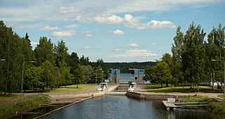
Lempäälä (Finnish:[ˈlempæːlæ] is a municipality in the Pirkanmaa region of Finland with 24,703 inhabitants. Lempäälä is located south of the city of Tampere. The municipality covers an area of 307.06 square kilometres of which 37.51 km2 is water. The population density is 91.64 inhabitants per square kilometre.

Parkano is a town and municipality in Finland.

Geta is a municipality in the northern part of Åland, an autonomous territory of Finland. The municipality has a population of 509 and covers an area of 605.99 square kilometres (233.97 sq mi) of which 522.14 km2 (201.60 sq mi) is water. The population density is 6.02 inhabitants per square kilometre (15.6/sq mi).
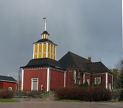
Isojoki is a municipality of Finland. It is part of the South Ostrobothnia region. The city of Pori is located 83 kilometres (52 mi) south of Isojoki. The population of Isojoki is 1,814 and the municipality covers an area of 642.4 km2 (248.0 sq mi) of which 5.05 km2 (1.95 sq mi) is inland water. The population density is 2.82/km2 (7.3/sq mi). The municipality is unilingually Finnish and neighbour municipalities are Honkajoki, Karijoki, Kauhajoki, Kristinestad, Merikarvia and Siikainen.

Isokyrö is a municipality of Finland. It is located in the South Ostrobothnia region, 43 kilometres (27 mi) from Vaasa. The municipality has a population of 4,357 and covers an area of 356.91 square kilometres (137.80 sq mi) of which 2.79 km2 (1.08 sq mi) is water. The population density is 12.3 inhabitants per square kilometre (32/sq mi).

Juupajoki is a municipality of Finland. It is located in the Pirkanmaa region. The municipality has a population of 1,708, which makes it the smallest municipality in Pirkanmaa in terms of population. It covers an area of 274.95 square kilometres (106.16 sq mi) of which 16.47 km2 (6.36 sq mi) is water. The population density is 6.61 inhabitants per square kilometre (17.1/sq mi). Korkeakoski is the administrative center of the municipality.

Jämijärvi is a municipality of Finland.

Karijoki is a municipality of Finland. It is part of the South Ostrobothnia region. The population of Karijoki is 1,188, which makes it the smallest municipality in South Ostrobothnia in terms of population. The municipality covers an area of 185.58 km2 (71.65 sq mi) of which 0.78 km2 (0.30 sq mi) is inland water. The population density is 6.4/km2 (17/sq mi). The municipality is unilingually Finnish.
Kauhajoki is a town and municipality of Finland. It is located in the province of Western Finland and is part of the Southern Ostrobothnia region, 59 kilometres (37 mi) southwest of the city of Seinäjoki. The population of Kauhajoki is 12,618 and the municipality covers an area of 1,298.98 km2 (501.54 sq mi) of which 16.46 km2 (6.36 sq mi) is inland water. The population density is 9.71/km2 (25.1/sq mi). The town is unilingually Finnish.

Keitele is a municipality of Finland.

Merijärvi is a municipality of Finland.

Mynämäki is a municipality of Finland located in the Southwest Finland region. Neighbouring municipalities are Aura, Eura, Laitila, Masku, Nousiainen, Pöytyä, Rusko, Taivassalo, Turku and Vehmaa.
Rusko is a municipality of Finland.

Siikajoki is a municipality of Finland. It is part of the North Ostrobothnia region. The municipality has a population of 4,838 (31 December 2023) and covers an area of 1,653.89 square kilometres (638.57 sq mi) of which 601.94 km2 (232.41 sq mi) is water. The population density is 4.58 inhabitants per square kilometre (11.9/sq mi). Neighbour municipalities are Hailuoto, Liminka, Lumijoki, Raahe and Siikalatva.
Tervo is a municipality of Finland. It is located in the province of Eastern Finland and is part of the Northern Savonia region. The municipality has a population of 1,410, making it Northern Savonia's least populous municipality. It covers an area of 494.30 square kilometres (190.85 sq mi) of which 146.52 km2 (56.57 sq mi) is water. The population density is 4.05 inhabitants per square kilometre (10.5/sq mi).

Tyrnävä is a municipality in the North Ostrobothnia region of Finland with a population of 6,525 (31 December 2023). It covers an area of 494.85 square kilometres (191.06 sq mi), of which 3.07 km2 (1.19 sq mi) is water. The population density is 13.27 inhabitants per square kilometre (34.4/sq mi). The municipality is unilingually Finnish. The city of Oulu is located about 30 kilometres (19 mi) north of the center of Tyrnävä.
Vesanto is a municipality of Finland. It is located in the Northern Savonia region. The municipality has a population of 1,893 and covers an area of 569.80 square kilometres (220.00 sq mi) of which 147.1 km2 (56.8 sq mi) is water. The population density is 4.48 inhabitants per square kilometre (11.6/sq mi).
Veteli is a municipality of Finland.

Akaa is a town and a municipality in Pirkanmaa, Finland. It was created on January 1, 2007 when the town of Toijala and the municipality of Viiala were united into a single town. The municipality of Kylmäkoski was consolidated with Akaa on 1 January 2011.

Kimitoön is a municipality and island of Finland. It was created on 1 January 2009, when the municipalities of Dragsfjärd, Kimito and Västanfjärd were consolidated into a single municipality.