Karwar

Last updated

Karwar
Kādwād
Carwar
Municipality /Taluk
Heading for a new journey at Tagore Beach.JPG
Bridge, Sadashivghad (1496158).jpg
Arabian sea from Sadashivgarh fort.JPG
Majali Beach, Devabhaga, Karwar.jpg
Clockwise from the Top:
Tagore Beach, Arabian Sea from Sadashivgad fort, Majali Beach, Bridge over Kali River
India Karnataka location map.svg
Red pog.svg
Karwar
India location map 3.png
Red pog.svg
Karwar
Coordinates: 14°48′N74°08′E / 14.80°N 74.13°E / 14.80; 74.13
CountryFlag of India.svg  India
State Karnataka
Region Karavali
District Uttara Kannada
Government
  TypeCity Municipal Council
Area
[1]
  Urban
36.95 km2 (14.27 sq mi)
  Taluk743.4 km2 (287.0 sq mi)
Elevation
6 m (20 ft)
Population
 (2011) [2]
   CMC+Outgrowth
77,139
  Taluk
155,213
Demonym Karwarkar
Language
  Official Kannada
  LocalKonkani
Time zone UTC+5:30 (IST)
PIN
581301
Telephone code91-8382
Vehicle registration KA 30
HDI (2014)Increase2.svg 0.900 (Very High) [3]
Literacy (2014)89.91 [3]
Sex ratio (2014)989 /1000 [3]
Website karwarcity.mrc.gov.in/en

Karwar is a seaside city, taluka, and administrative headquarters of Uttara Kannada district lying at the mouth of the Kali river on the Kanara coast of Karnataka state, India.

Contents

Karwar is a popular tourist destination with an urban area of 36.95 km2 (14 sq mi) in Karwar taluk which is known for beaches and tourism.

Etymology

Karwar, also known locally as "Kādwād", derived its name from the nearby village of "Kade-Wādā". In the local Kannada, Kade means "last" and Wādā means "precinct". Hence, Kade-Wādā ("the last neighbourhood") referred to the southernmost Konkani-speaking village. During the Crown rule in India, the name "Karwar" was spelt as "Carwar". [4] The ancient name was "Baithkhol"—from an Arabic term Bait-e-kol— meaning the "bay of safety". This is in the Indian history for maritime trade wherein black peppercorns, cardamom, and muslin cloth were exported from this Kādwād port and after the war with Veer Henja Naik (1803), the port activities were shifted to Baithkhol. Thereafter, the port of Kādwād was isolated and Kurmagad Fort was activated by the Portuguese.

History

Kali River and Sadashivgad fort Sadashivgad Fort & Kali Bridge as seen from Nandangadda Village.jpg
Kali River and Sadashivgad fort
Kali river bridge, Karwar Kali river bridge.jpg
Kali river bridge, Karwar
Leisure boats on Kali River Leisure boats on Kali River.jpg
Leisure boats on Kali River

Karwar township was built by the British in the year 1857 after the Mutiny. Karwar is popularly known as the "Kashmir of Karnataka". Prior to 1857, Karwar did not exist as a town. Honnavara was the district headquarters of Canara district consisting up to Mangalore to Kodibag Karwar, up till Kali river; and Karwar village (Kādwād) existed as hamlets like Habbuwada, Kajubag, Kodibag, Kone, Baad, Kathinkon, Sunkeri, Shirwad, and Binaga. After that, the river bank towards the north was under the rule of Sadhashiv Nayak and Maratha Confederacy. After the mutiny of 1857, the British made division of Canara District into two parts as South Canara with headquarters at Mangalore attached to Madras Presidency and North Canara with headquarters at the newly built town Karwar, which was attached to Bombay Presidency. It is a planned city like Panaji, Mumbai, Dharwad, and Bengaluru. After the rule of the Indian Government from 1947, Karwar is more or less neglected politically and kept without major developments.

Ancient history

Portuguese traders knew Karwar as Cintacora, Chitrakul, Chittakula or Sindpur. In 1510, the Portuguese captured and burnt a fort at Karwar. They called it Fort Pir, Forte de Piro or Pito due to the presence of a Muslim Dargah (tomb of a Sufi saint, Shahkaramuddin).

In 1638 the English Trading Courteen Association established a factory at Kadwad village, 6 km east of Karwar and traded with merchants from Arabia and Africa. The common commodities were muslin, black pepper, cardamom, cassier and coarse blue cotton cloth. In 1649 the Courteen Association merged with the British East India Company, and Karwar became a company town. The East India Company built fighting ships in the Karwar harbour. For example, the Britannia (1715) which had 18 guns was built to defend Bombay from attacks by Maratha Koli [5] admiral Kanhoji Angre. [6]

In the 1700s, Karwar was a part of the Maratha Empire. Having marched from Bednore in the south, visiting on his way the sacred temple at Gokarna, Shivaji seized Ankola and the next day came to Karwar (then known as Kadwad). Both the East India Company and Sher Shah, the Sardar of Bijapur, were very much alarmed at this sudden development. They collected a huge amount and offered it to Shivaji, praying that they may be spared. Satisfied at the recognition of his authority, Shivaji crossed the Kali River and conquered Sadashivgad on 21 February 1665.

In 1784, at the time of the Treaty of Mangalore between Tipu Sultan and the East India Company, "Treaty of Mangelore" Archived 20 July 2008 at the Wayback Machine Project South Asia.</ref> After the defeat of the Marathas in the Third Anglo-Maratha War, Karwar was captured by the British. Kot Siveshvar, another fortress, was built near Karwar (in Siveshvar village) by the Sultan of Bijapur to counterattacks from the north.

At the ruins of Fort Siveshvar are a Muslim graveyard and a tunnel at the eastern gate. The Bengali poet and Nobel laureate Rabindranath Tagore, who visited Karwar in 1882, dedicated a chapter of his memoirs to this town. [7] At 22 years, Tagore stayed with his second brother, Satyendranath Tagore, who was a district judge in Karwar.

From 1862 until the re-organization of the Indian states after Independence, Uttara Kannada district was a part of the Bombay Presidency. During this period, major public works carried out included the improvement of roads, the building of a wharf, wharf road and a sea wall at the Karwar port as well as the construction of a multi-floor storage building, staff housing, a post office, kutcheri (kutcherries or zamindar's offices) and a Christian burial ground. [8] At the same time, the local Konkani-speaking people had close connections with Mumbai and Goa. Many Marathi middle schools were established in Karwar and Joida taluks, despite the fact that the local populace mostly were Konkani native speakers.

During World War II Karwar was an Indian Naval training site. [9] :172

Post-Independence

Post-Independence Karwar was made a part of newly formed Mysore state following requests by the people of Karwar. Karwar during the 1950–60s played important role in the Konkani language agitation, helping cement Konkani as an independent language during Konkani conferences held in Karwar. The city played an important role in Konkan culture and Konkani culture hosting many Konkani conferences to promote the language. There have been demographic shifts since the state reorganizations act, and Karwar is no longer the stronghold for Konkani culture and has been overtaken by Panaji (or Panjim), Goa (after Goa achieved statehood) and by Mangalore [10] .The city is also neglected by the state government and devoid of development. Spots of attractions are usually underfunded, relatively little money is allowed for development and people have to constantly rely on the neighboring state of Goa to carry out their needs. [11]

Geography

Map of Karwar Taluk Karwar Taluka Map.png
Map of Karwar Taluk

Karwar is a seaport on the west coast of peninsular India. To the east are the Western Ghats. Karwar is situated on the banks of the Kali river which flows west to the Arabian sea from its headwaters at Bidi village in the Western Ghats. The Kali river has a length of about 150 km (93 mi) and is the main source of irrigation in the region.

Baitkhol port at Karwar is a natural harbour with land side hills and ocean side islands protecting it from cyclonic weather. The four fathom mark lies close to the shore. The tidal range is 1.5–2.5 m (5–8 ft). [9] :172

Biodiversity

Local bird, Sturnia blythii. Karwar is rich in flora and fauna Sturnia blythii.jpg
Local bird, Sturnia blythii. Karwar is rich in flora and fauna

Several small mangrove covered islands lie off the Kali river estuary including Anjediva Island and Devagadaguda Islands. The sub-tidal regions of the islands have a high biodiversity, although the waters off Karwar have recorded higher than normal faecal coliform counts. [12] :248

Climate

Karwar lies on a coastal strip known as the Monsoon Coast. [13] Karwar has hot and humid summers (27–34 °C (81–93 °F)) from March to May where the temperature may peak to 38 °C (100 °F). The Arabian Sea is warm throughout the year. Winters from December to February are mild (23–29 °C (73–84 °F)) and seldom plummet to 20 °C (68 °F). The windy monsoon period from June to September has an average rainfall of over 400 cm (160 in).

Climate data for Karwar (1981–2010, extremes 1901–2012)
MonthJanFebMarAprMayJunJulAugSepOctNovDecYear
Record high °C (°F)38.2
(100.8)
39.1
(102.4)
39.6
(103.3)
38.9
(102.0)
37.4
(99.3)
36.6
(97.9)
32.8
(91.0)
33.3
(91.9)
34.0
(93.2)
39.4
(102.9)
37.8
(100.0)
37.2
(99.0)
39.6
(103.3)
Mean daily maximum °C (°F)32.8
(91.0)
32.4
(90.3)
32.7
(90.9)
33.5
(92.3)
33.5
(92.3)
30.9
(87.6)
29.6
(85.3)
29.5
(85.1)
30.2
(86.4)
31.9
(89.4)
33.5
(92.3)
33.4
(92.1)
32.0
(89.6)
Mean daily minimum °C (°F)19.2
(66.6)
19.7
(67.5)
22.7
(72.9)
25.3
(77.5)
26.7
(80.1)
25.1
(77.2)
24.5
(76.1)
24.3
(75.7)
24.2
(75.6)
23.9
(75.0)
22.2
(72.0)
20.4
(68.7)
23.2
(73.8)
Record low °C (°F)12.7
(54.9)
11.6
(52.9)
15.6
(60.1)
17.2
(63.0)
20.3
(68.5)
18.3
(64.9)
18.3
(64.9)
20.3
(68.5)
20.5
(68.9)
16.8
(62.2)
13.7
(56.7)
12.5
(54.5)
11.6
(52.9)
Average rainfall mm (inches)0.1
(0.00)
0.1
(0.00)
0.2
(0.01)
8.9
(0.35)
123.1
(4.85)
964.8
(37.98)
965.0
(37.99)
684.8
(26.96)
305.6
(12.03)
194.5
(7.66)
31.4
(1.24)
7.0
(0.28)
3,285.6
(129.35)
Average rainy days0.10.00.10.64.522.626.524.313.67.32.10.5102.2
Average relative humidity (%) (at 17:30 IST)60636868718285858176655972
Source: India Meteorological Department [14] [15]

Demographics

The total population in Karwar town with outgrowth is 77,139 as of 2011 by Indian Government. As of 2011, Karwar had an average literacy rate of 93%, higher than the national average of 74%. Males constitutes 49.7% of population and 50.3% are females. [16] [3] In Karwar, 10% of the population were children under six years of age.

Language

Languages spoken as of 2011 in Karwar Taluk. [17]

   Konkani (54%)
   Kannada (30%)
   Urdu (6%)
   Hindi (3%)
   Marathi (2%)
  Others (5%)

Languages spoken as of 2011 in Karwar Urban. [18]

   Konkani (53%)
   Kannada (30%)
   Urdu (10%)
   Hindi (2%)
   Marathi (2%)
  Others (3%)

Languages spoken as of 2011 in Karwar Rural. [19]

   Konkani (54%)
   Kannada (31%)
   Urdu (3%)
   Hindi (4%)
   Marathi (2%)
  Others (6%)

Border issues

Karwar taluka is majorly Konkani by first language speakers. It was part of the Bombay Presidency during the British colonial rule, before the reorganization of states. The native Konkani speakers had close connections with Bombay which extended to matrimonial relations too. Many Marathi-medium schools were also established in Karwar and Joida talukas. Marathi films were often released in Karwar. The visit of Marathi drama troupes from Bombay and Poona was an annual feature. However, Konkani-speaking people were disenchanted when Marathis began to claim Konkani as a dialect of Marathi. They disputed it and asserted that Konkani had independent status as a language. It was the native Konkani-speaking people led by late P. S. Kamat who argued before Mahajan Commission that Karwar was an integral part of Karnataka.

There have been recent assertions by both Maharashtra and Goa that Karwar should belong to their states. [20] [21]

Religion

Sunset at Karwar bay Karwar Evening.jpg
Sunset at Karwar bay

Most people in Karwar are Hindu. Christianity was introduced to Karwar by the Portuguese while ruling Goa in the 16th and 17th centuries and contemporary Karwari Catholics are descendants of those early Christians. Muslim seafaring traders migrated to Karwar from the Deccan (Bahamani) kingdoms. Karwar was called Baithkol meaning the "house of safety" or Bait-e-kol meaning "place of safety" in Arabic. Muslim villages in Karwar include: Shiveshvar, Chittakula, Sawar Pai, and Hotegali. Islamic tradition holds that two brothers, descendants of Ali, the son-in-law of Muhammad, settled in Shiveshvar and made the village a place of Islamic learning. In Shiveshvar, there are three shrines dedicated to Muslim saints: Gaiby Pir, Nizam Pir, and Shamshuddin pir-in Kot.

Some famous Historic Mutt & Temples

Primary industry

Fishermen returning home at sunset, Devbagh, Karwar Devbagh.jpg
Fishermen returning home at sunset, Devbagh, Karwar

Karwar is an agricultural region. The common crops are rice, groundnuts, green vegetables, onions, watermelons, and flowers. Other primary industries include animal husbandry, sericulture, horticulture, beekeeping, gathering and lumbering and the growing of homeopathic medicinal plants.

The coastal location of Karwar lends to fishing and fisheries which are concentrated in Harikanth, Konkan Kharvis, Gabiths and Ambigas. The common types of fish are mackerel, sardines, hardheads and prawns. Fishing is done from land with nets or from boats such as pandy (motor launch) and dhoni (dug out canoes). There is also mechanised trawling. The brackish water of the Kali estuary is suitable for prawn farming. [22]

Secondary industry

Muslin used in dress making Fitting muslin dummy.jpg
Muslin used in dress making

Members of the Daivadnya Brahmin caste are engaged in jewellery design, manufacturing and goldsmithing. Leather works are common. Since 1638 when William Counten opened a mill, Karwar town has been a producer of fine muslin.[ citation needed ] In the 1660s the factory was prosperous, exporting the finest muslins in Western India; the weaving country was inland to the east, at Hubli and other centres, where as many as 50,000 weavers were employed. Besides the great export of muslin, Karwar provided pepper, cardamoms, cassia, and coarse blue cotton cloth (dungan). I [23] [ citation needed ]

In Binaga township, a chemical company Aditya Birla Chemicals (earlier owned by Ballarpur Industries Ltd / Solaris Chemtech), manufactures caustic soda lye and flakes, chlorine, hydrochloric acid, phosphoric acid, kestra pipes and bromine. [12] :246

Tertiary industry

At Kaiga, 50 kilometres (31 mi) away, the Nuclear Power Corporation of India operates an 880 MW nuclear power plant. The Karnataka Power Corporation Ltd. operates a dam and 150 MW power house between Kadra and Mallapur townships, approximately 33 kilometres (21 mi) from Karwar town.

INS Kadamba

The Indian Navy operates a naval base at a bay near Binaga township. It is the navy's third largest base. The base was founded as part of Project Seabird. Casurina beach near Binaga (now called Kamat Bay) and Arga beach were incorporated into naval property. The public has access to the base during Navy Week in December and in visiting educational groups. The naval base includes a civilian support community at Amadalli, a ship lift and an hospital. INS Kadamba is the homeport of India's largest aircraft carrier INS Vikramaditya.

INS Vajrakosh

INS Vajrakosh, commissioned on 9 September 2015, is the latest establishment of the Indian Navy at Karwar which will serve as special storage facility for specialised armaments and missiles. INS Vajrakosh will have all the required infrastructure and will be staffed by specialists to provide specialised servicing facilities for these sophisticated missiles and ammunition. [24]

Aditya Birla Chemicals

Aditya Birla Chemicals (India) (ABCIL) is a unit of the Aditya Birla Group.

ABCIL has also acquired chlor-alkali and phosphoric acid division of Ballarpur Industries Ltd / Solaris Chemtech Industries Limited, based in Karwar, Karnataka.

Transport

Karwar
Karwar
Karwar

Karwar International Airport

The proposed Karwar Airport will be built by the Indian Navy at Alageri village [25] near Ankola, in Karnataka. The Airports Authority of India (AAI) will operate a civil enclave at the naval air base which is part of the Navy's Rs 100 billion Phase 2 of Project Seabird. After the construction Karwar will be the second city in Karnataka to have all 3 major modes of transport (Air, Sea, Land)

Konkan railway

Karwar railway station Karwar Railway Station.jpg
Karwar railway station

The Konkan Railway connects Karwar to most major towns and cities. Karwar has three railway stations: Karwar, Asnoti and Harwada. The nearest Goan station is Canacona, 36 km away. Madgaon Junction lies 68 km to the north. [26] and Mangalore Junction 253 km to the south.

Port

Karwar beach looking towards Madlimgadh and Kurumgad Islands Karwar Beach.jpg
Karwar beach looking towards Madlimgadh and Kurumgad Islands

Karwar port is located at Baithkol, Karwar Bay. Hills and coastal islands make the port a natural harbour, sheltered from the Arabian sea. The port which is operated by the Government of Karnataka, services the hinterland of northern Karnataka, Goa and southern Maharashtra.

The length of the port is 355 metres (388 yd). The quay has two berths, with a draft capacity of 9.25 metres (30.3 ft). Karwar port also berths coastal vessels and there is a jetty for fishing vessels. [27] The Government of Karnataka has planned to develop Karwar port on a Public Private Partnership (PPP) basis to provide six additional berths, a container terminal, and a rail link to Karwar railway station.

The port is able to handle all types of commodities, including "B" and "C" class petroleum products. There port has liquid storage tanks for bitumen, furnace oil, molasses, and HSD. A ban of iron ore mining and export in Karnataka state reduced congestion at the port. The port has arrangements for berthing coastal vessels, and a jetty for fishing boats.

In 2012 the Government of Karnataka carried out maintenance dredging in the port, the approach channel and the nearby anchorage. The port may be closed from 16 May to 15 September (the monsoon season). [27] Part of the 2008 Hindi film Golmaal Returns was filmed at Karwar port.

Tourism

Rabindranath Tagore beach

Rabindranath Tagore Statue at the Beach Rabindranath Tagore At The Rabindranath Tagore Beach.jpg
Rabindranath Tagore Statue at the Beach
Glazing Rays on Rabindranath Tagore Beach Glazing Rays on Rabindranath Tagore Beach, Karwar.jpg
Glazing Rays on Rabindranath Tagore Beach
Tagore beach Heading for a new journey at Tagore Beach.JPG
Tagore beach
"The sea beach of Karwar is certainly a fit place in which to realize that the beauty of Nature is not a mirage of the imagination, but reflects the joy of the Infinite and thus draws us to lose ourselves in it. Where the universe is expressing itself in the magic of its laws it may not be strange if we miss its infinitude; but where the heart gets into immediate touch with immensity in the beauty of the meanest of things, is any room left for argument?" – Rabindranath Tagore [7]

Places of interest

Maritime museum at Tagore beach, Rabindranath IMS Chapal.jpg
Maritime museum at Tagore beach, Rabindranath
Sadashivgad Fort from the Kali River Bridge View of Sadashivgad Hill fort from the Kali River Bridge.jpg
Sadashivgad Fort from the Kali River Bridge

Seaside

  • Kali River Garden, Kodibag
  • Rock Garden, Karwar
  • Binaga Beach
  • Devbagh Beach
  • Kali Bridge
  • Karwar Beach
  • Kurumgad Island
  • Majali Beach
  • Oyster Rock Lighthouse, a round white masonry construction with red trim protects ships from the rocks of Devgad Island, the largest off the Kali Estuary. [27]
  • Tilmatti beach, A black sand beach

Hinterland

  • Anshi National Park
  • Kadra & Kodsalli dam
  • Chaitanya Park
  • Chendia and Nagarmadi falls (a small waterfall which passes under a large rock)
  • Devkar Falls
  • Guddahalli Peak
  • Habbu Mountain
  • Hyder Ghat Pass
  • Mudgeri Dam
  • Shirve Ghat
  • Makkeri

Historic sites

  • Kot Shiveshvar
  • Shri Narasimha temple, Siddar
  • Sadashivgad Fort
  • Shahkaramuddin dargah, Sadashivgad (tomb of a Sufi saint)
  • Maritime museum

Culture

Cuisine

Karwar is known for its seafood cuisine. Fish curry, with cashews, coconut and rice is a staple dish. Karwar curries use ginger and turmeric but not always garlic. [28]

Kurle Ambat (crab masala), a local dish Crabmasala.jpg
Kurle Ambat (crab masala), a local dish

Local festivals

Media

Media outlets include:

Education

Karwar has Government and private engineering college and Government medical college. The city has private and Government schools and institutions for PU, diploma and ITI courses.

Government Polytechnic is also located in the area.

Notable residents

The above are few notable residents for KARWAR

Villages of Karwar

Karwar comprises the following blocks or villages:[ citation needed ]

* Ambrai

See also

Related Research Articles

<span class="mw-page-title-main">Uttara Kannada</span> District of Karnataka, India

Uttara Kannada is a district in the Indian state of Karnataka. It is a major coastal district of Karnataka, and is the third largest district in Karnataka. It is bordered by the state of Goa and Belagavi districts to the north, Dharwad District and Haveri District to the east, Shivamogga District, and Udupi District to the south, and the Laccadive Sea to the west.

<span class="mw-page-title-main">Konkan</span> Region of Southwest India

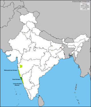
The Konkan is a stretch of land by the western coast of India, bound by the river Daman Ganga at Damaon in the north, to Anjediva Island next to Karwar town in the south; with the Arabian Sea to the west and the Deccan plateau to the east. The hinterland east of the coast has numerous river valleys, riverine islands and the hilly slopes known as the Western Ghats; that lead up into the tablelands of the Deccan. The region has been recognised by name, since at least the time of Strabo in the third century CE. It had a thriving mercantile port with Arab tradesmen from the 10th century. The best-known islands of Konkan are Ilhas de Goa, the site of the Goa state's capital at Panjim, and the Seven Islands of Bombay, on which lies Mumbai, the capital of Maharashtra and the headquarters of the Konkan Division.

<span class="mw-page-title-main">Kanara</span> Region in Karnataka, India

Kanara or Canara, also known as Karavali is the historically significant stretch of land situated by the southwestern coast of India, alongside the Arabian Sea in the present-day Indian state of Karnataka. The subregion comprises three civil districts, namely: Uttara Kannada, Udupi, and Dakshina Kannada. Kassergode was included prior to the States Reorganisation Act.

<span class="mw-page-title-main">Konkani language</span> Indo-Aryan language spoken in India

Konkani is an Indo-Aryan language spoken by the Konkani people, primarily in the Konkan region, along the western coast of India. It is one of the 22 scheduled languages mentioned in the Indian Constitution, and the official language of the Indian state of Goa. It is also spoken in Karnataka, Maharashtra, Kerala, Gujarat as well as Damaon, Diu & Silvassa.

Ankola is a Town Municipal Council and a taluka in Uttara Kannada district of the Indian state of Karnataka. The name of the place is derived from a forest shrub Ankola grown on the coastal hill side and worshiped by the Halakki Vokkaligas as a totem. The town is around 33 km (21 mi) from Karwar and 86 km (53 mi) from Sirsi.

Karnataka's coastline called Karavali stretches 300 km between Mangalore in Dakshina Kannada district and Karwar in Uttara Kannada district. The coastline of Karnataka has been along the eastern shore of Arabian Sea. Karnataka has one major and ten minor ports in this coastal belt. Kali, Belekeri, Gangavali, Aghanashini Sharavathi, Sharabi, Kollur, Gangolli, Sitanadi, Gurpur and Netravati are the important rivers in this belt which empty into the Arabian sea. Sea erosion, migration of river mouths, siltation of ports and harbours are some of the problems common to this belt.

Joida is a town located in the Uttara Kannada district in the Indian state of Karnataka. The town is the headquarters of the eponymous taluk. Earlier it was known as Supa taluka but as Supa village got submerged due to dam built across river Kali, Joida taluka came into existence. Joida town has a Post office, branch of nationalised banks and a Police station.

<span class="mw-page-title-main">Kali River (Karnataka)</span> River in Karnataka, India

The Kali River or Kaali Nadi is a river flowing through Uttara Kannada district of Karnataka state in India. The river rises near Kushavali, a small village in Uttar Kannada district. The river is the lifeline to some 400,000 people in the Uttara Kannada district and supports the livelihoods of tens of thousands of people including fishermen on the coast of Karwar. There are many dams built across this river for the generation of electricity. One of the important dams build across Kali river is the Supa Dam at Ganeshgudi. The river runs 184 kilometers before joining Arabian Sea.

The Kannada Vaishya in Uttara Kannada (India) are a small sect of people. They are mainly found in Ankola and Karwar taluks of the district.

Konkani may refer to:

Mangaloreans are a collection of diverse ethnic groups that hail from the historical locales of South Canara (Tulunaad) on the south western coast of Karnataka, India, particularly the residents native to Mangaluru.

<span class="mw-page-title-main">Tadadi</span> Village in Karnataka, India

Tadadi (Tadari) is one of the ports in Uttara Kannada, Karnataka, India. It is near Gokarna in Kumta taluk.

<span class="mw-page-title-main">Sadashivgad</span> Village located in Karwar District

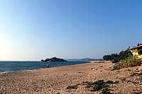
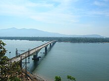
Sadashivgad is a village located in Karwar, Uttara Kannada district, in the state of Karnataka in India. Significant and picturesque, it is now a popular tourist destination located by the Kali river bridge, which has been built at the confluence of the river and the Arabian Sea.

Asnoti is a village in Karwar Taluka, Uttara Kannada district, Karnataka, India. It is close to the historic fort of Sadashivgad located on Kali river. Konkani is spoken as a local language.

<span class="mw-page-title-main">Canarese Konkani</span> Regional language between Goa and Mara

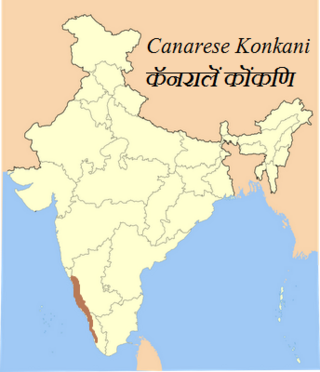
Canarese Konkani are a set of dialects spoken by minority Konkani people of the Canara sub-region of Karnataka, and also in Kassergode of Kerala that was part of South Canara.

Konkani is a southern Indo-Aryan language belonging to the Indo-European family of languages spoken in the Konkan coastal region of India. It has approximately 3.6 million speakers.

The Konkani language agitations were a series of protests and demonstrations in India, concerning the uncertain future of the Konkani language. They were held by Goans in the former territory of Goa, Daman and Diu; then under the administration of the Maharashtrawadi Gomantak Party (MGP). The protests involved citizen journalism, student activism & political demonstrations. The civil unrest ceased when official status for Konkani in the Devnagari script was granted.

Mudgeri is a village in Karwar Taluka, Uttara Kannada district, Karnataka, India. It is close to the historic fort of Sadashivgad located on Kali river. Konkani is spoken as a local language.

<span class="mw-page-title-main">Karwar railway station</span> Railway station in Karnataka, India

Karwar railway station is one of the main railway station in Uttara Kannada, Karnataka. Its code is KAWR. It is the headquarters of the Karwar Division of Konkan Railway(Pernem-Thokur). It serves Karwar city. The station consists of two platforms. Karwar has three nearby railway stations: Karwar, Asnoti and Harwada. A 1.69 km (1.05 mi) railway bridge on Kali River falls before Karwar Railway Station while travelling from the side of Goa. The town of Karwar is situated beside Kali River.

Chendia-Todur is a twin village in the Karwar Taluk of Uttar Kannada District of Karnataka. It lies 13 km south of the city of Karwar, 257 km north of the chief port city Mangalore and 489 km from the state capital Bangalore.

References

  1. "Karwar city population". www.citypopulation.de/en.
  2. "Sub-District Details". Office of the Registrar General & Census Commissioner, India. Retrieved 27 March 2012.
  3. 1 2 3 4 Zilla Panchayat Uttara Kannada District Overview 2014 http://www.zpkarwar.kar.nic.in/docs/publication/English/EnglishPart2.pdf
  4. "Full text of "History_Of_Gingee_And_Its_Rulers"". archive.org. Retrieved 16 November 2022.
  5. LT GEN K. J., SINGH (5 November 2018). "As NDA cadet, I was witness to Vice Admiral Awati's kindness". ThePrint.In. Retrieved 7 November 2018.
  6. Biddulph, Colonel John (1907). The Pirates of Malabar And an Englishwoman in India Two Hundred Years Ago (Reprint 2005 ed.). London: Smith, Elder & co. p. 40. ISBN   9781846377280.
  7. 1 2 Karwar in Tagore's memoirs. online-literature.com
  8. "Report of proceedings at the conference held at Poona, 1865." Department of Public Works, Bombay Presidency, 1866 p. 251 (Original held at Oxford University). Accessed at Google Books, 5 April 2014.
  9. 1 2 Hiranandani G. M. "Transition to Eminence: The Indian Navy 1976–1990." Lancer Publishers, 2005. ISBN   8170622662, 9788170622666.
  10. "A bridge between languages | Deccan Herald". 24 October 2020.
  11. "No jobs in Karwar, youth going to Goa daily for work". 30 November 2018.
  12. 1 2 Sahoo D. and Pandey P. C. "Advances in Marine and Antarctic Science." APH publishing 2002 ISBN   8176483478, 9788176483476.
  13. Outlook Traveller Outlook Publishing July 2008 8(7)
  14. "Station: Karwar Climatological Table 1981–2010" (PDF). Climatological Normals 1981–2010. India Meteorological Department. January 2015. pp. 397–398. Archived from the original (PDF) on 5 February 2020. Retrieved 19 April 2020.
  15. "Extremes of Temperature & Rainfall for Indian Stations (Up to 2012)" (PDF). India Meteorological Department. December 2016. p. M98. Archived from the original (PDF) on 5 February 2020. Retrieved 19 April 2020.
  16. "Karwar city population". www.citypopulation.de/en.
  17. "C-16 Population By Mother Tongue Of Karwar Taluk".
  18. "C-17 Population By Mother Tongue Of Karwar Urban".
  19. "C-18 Population By Mother Tongue Of Karwar Rural".
  20. "Maharashtra-Karnataka border row: Ajit Pawar's remarks trigger fresh row; don't incite fire, cautions BSY". www.timesnownews.com. Retrieved 4 December 2020.
  21. "Konkani-speaking areas in Karwar yearn for Goa | Goa News - Times of India". The Times of India. TNN. 17 February 2013. Retrieved 4 December 2020.
  22. Qasim S. Z. "Indian Estuaries." Allied Publishers 2003 p270 ISBN   817764369X, 9788177643695.
  23. http://www.burmalibrary.org/docs20/The_Imperial_Gazetteer_Of_India-Vol.15-tu-red.pdf [ bare URL PDF ]
  24. "रक्षा मंत्री ने कारवाड़ में आईएनएस वज्रकोष को राष्ट्र को समर्पित किया". पत्र सूचना कार्यालय, भारत सरकार. 9 September 2015. Retrieved 22 September 2015.
  25. "Project Seabird all set to enter Phase-2". The Times of India . 5 December 2009. Archived from the original on 3 January 2013. Retrieved 1 May 2012.
  26. "Karwar/KAWR Railway Station – Today's train departure timings, a busy junction for travellers and rail enthusiasts". India Rail Info. 30 May 2012. Retrieved 12 September 2012.
  27. 1 2 3 "Prostar Sailing Directions 2005 India & Bay of Bengal Enroute." National Geospatial-intelligence Agency, ProStar Publications, 2005 p. 53 ISBN   1577856627, 9781577856627.
  28. Tennebaum T. D. "A Sense for Spice : Recipes and Stories from a Konkan Kitchen." Westland ISBN   938261849X, 9789382618492.
  29. http://www.karwarenews.com Archived 4 February 2009 at the Wayback Machine Karwar e news online newspaper
  30. http://www.munjavu.com Munjavu daily newspaper website