Kelford, North Carolina

Last updated

Kelford, North Carolina
NCMap-doton-Kelford.PNG
Location of Kelford, North Carolina
Coordinates: 36°10′52″N77°13′27″W / 36.18111°N 77.22417°W / 36.18111; -77.22417
Country United States
State North Carolina
County Bertie
Area
[1]
  Total0.48 sq mi (1.25 km2)
  Land0.48 sq mi (1.25 km2)
  Water0.00 sq mi (0.00 km2)
Elevation
[2]
92 ft (28 m)
Population
 (2020)
  Total203
  Density421.16/sq mi (162.53/km2)
Time zone UTC-5 (Eastern (EST))
  Summer (DST) UTC-4 (EDT)
ZIP code
27847
Area code 252
FIPS code 37-35360 [3]
GNIS feature ID2405932 [2]

Kelford is a town in Bertie County, North Carolina, United States. The population was 251 at the 2010 census. [4]

Contents

Geography

According to the United States Census Bureau, the town has a total area of 0.46 square miles (1.2 km2), all land. [4]

Demographics

Historical population
CensusPop.Note
1900 167
1910 31689.2%
1920 223−29.4%
1930 458105.4%
1940 456−0.4%
1950 405−11.2%
1960 362−10.6%
1970 295−18.5%
1980 254−13.9%
1990 204−19.7%
2000 24520.1%
2010 2512.4%
2020 203−19.1%
U.S. Decennial Census [5]

As of the census [3] of 2000, there were 245 people, 99 households, and 51 families residing in the town. The population density was 481.3 inhabitants per square mile (185.8/km2). There were 116 housing units at an average density of 227.9 per square mile (88.0/km2). The racial makeup of the town was 32.65% White, 65.31% African American, and 2.04% from two or more races.

There were 99 households, out of which 24.2% had children under the age of 18 living with them, 25.3% were married couples living together, 19.2% had a female householder with no husband present, and 47.5% were non-families. 44.4% of all households were made up of individuals, and 26.3% had someone living alone who was 65 years of age or older. The average household size was 2.47 and the average family size was 3.69.

In the town, the population was spread out, with 29.8% under the age of 18, 9.4% from 18 to 24, 20.0% from 25 to 44, 24.9% from 45 to 64, and 15.9% who were 65 years of age or older. The median age was 38 years. For every 100 females, there were 87.0 males. For every 100 females age 18 and over, there were 75.5 males.

The median income for a household in the town was $21,750, and the median income for a family was $29,375. Males had a median income of $22,000 versus $20,972 for females. The per capita income for the town was $9,945. About 22.6% of families and 27.5% of the population were below the poverty line, including 32.9% of those under the age of eighteen and 44.7% of those 65 or over.

Education

Notable people

Related Research Articles

<span class="mw-page-title-main">Bertie County, North Carolina</span> County in North Carolina, United States

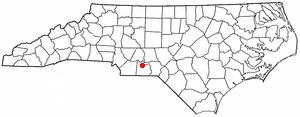
Bertie County is a county located in the northeast area of the U.S. state of North Carolina. As of the 2020 census, the population was 17,934. Its county seat is Windsor. The county was created in 1722 as Bertie Precinct and gained county status in 1739.

<span class="mw-page-title-main">Orient, Maine</span> Town in the state of Maine, United States

Orient is a town in Aroostook County, Maine, United States. The population was 156 at the 2020 census.

<span class="mw-page-title-main">Portage Lake, Maine</span> Town in the state of Maine, United States

Portage Lake is a town in Aroostook County, Maine, United States. The population was 359 at the 2020 census.

<span class="mw-page-title-main">Stockholm, Maine</span> Town in the state of Maine, United States

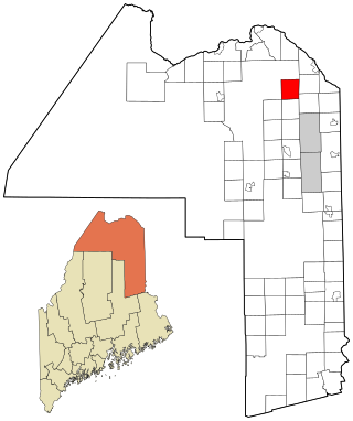
Stockholm is a town in Aroostook County, Maine, United States. The population was 250 at the 2020 census.

Stacyville is a town in Penobscot County, Maine, United States, in the foothills of Mount Katahdin. The population was 380 at the 2020 census.

<span class="mw-page-title-main">Mercer, Maine</span> Town in Maine, United States

Mercer is a town in Somerset County, Maine, United States. The town was named after the Revolutionary War hero Hugh Mercer. The population was 709 at the 2020 census.

<span class="mw-page-title-main">Ansonville, North Carolina</span> Town in North Carolina, United States

Ansonville is a town in Anson County, North Carolina, United States. The population was 440 at the 2020 census. The town has a total area of 1.5 square miles (3.8 km2), all land. It is located on the northern edge of Anson County, about a mile west of the Pee Dee River.

<span class="mw-page-title-main">Askewville, North Carolina</span> Town in North Carolina, United States

Askewville is a town in Bertie County, North Carolina, United States. The population was 241 at the 2010 census.

<span class="mw-page-title-main">Aulander, North Carolina</span> Town in North Carolina, United States

Aulander is a town in Bertie County, North Carolina, United States. The population was 895 at the 2010 census.

<span class="mw-page-title-main">Lewiston Woodville, North Carolina</span> Town in North Carolina, United States

Lewiston Woodville is a town in Bertie County, North Carolina, United States. The population was 549 at the 2010 census. It is the location of Perdue Farms, one of the largest chicken-producing companies in North Carolina.

<span class="mw-page-title-main">Powellsville, North Carolina</span> Town in North Carolina, United States

Powellsville is a town in Bertie County, North Carolina, United States. The population was 276 at the 2010 census. The city is home to Travis Bond

<span class="mw-page-title-main">Roxobel, North Carolina</span> Town in North Carolina, United States

Roxobel is a town in northwestern Bertie County, North Carolina, United States. It dates to 1724 and was originally known as Cotten's Cross Roads. After several name changes, it has remained Roxobel since 1849. The population was 240 at the 2010 census.

<span class="mw-page-title-main">Windsor, North Carolina</span> Town in North Carolina, United States

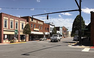
Windsor is a town in Bertie County, North Carolina, United States. The population was 3,630 at the 2010 census, up from 2,283 in 2000. It is the county seat of Bertie County, which is also the homeland of the Southern Band Tuscarora Tribe that remained in North Carolina post Colonialism. Windsor is located in North Carolina's Inner Banks region.

Sandyfield is a town in Columbus County, North Carolina, United States. The population was 447 at the 2010 census.

<span class="mw-page-title-main">Ruth, North Carolina</span> Town in North Carolina, United States

Ruth is a town in Rutherford County, North Carolina, United States. The population was 440 at the 2010 census.

<span class="mw-page-title-main">Lodge, South Carolina</span> Town in South Carolina, United States

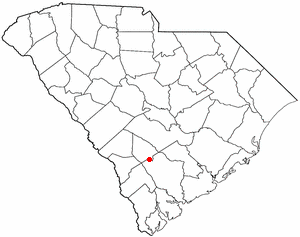
Lodge is a town in Colleton County, South Carolina, United States. The population was 120 at the 2010 census.

<span class="mw-page-title-main">West Union, South Carolina</span> Town in South Carolina, United States

West Union is a town in Oconee County, South Carolina, United States. Although its name suggests that it is near Union, they are approximately four counties apart. The population was 291 at the 2010 census.

<span class="mw-page-title-main">Anawalt, West Virginia</span> Town in West Virginia, United States

Anawalt is a town in McDowell County, West Virginia, United States. At one time it was known as Jeanette. It is named in honor of James White Anawalt, who was then manager of Union Supply Company, a subsidiary of the United States Steel Company. The population was 186 at the 2020 census. Coal mining was the town's chief industry.

<span class="mw-page-title-main">Iaeger, West Virginia</span> Town in West Virginia, United States

Iaeger is a town in McDowell County, West Virginia, United States. The population was 257 at the 2020 census.

<span class="mw-page-title-main">Mabscott, West Virginia</span> Town in West Virginia, United States

Mabscott is a town in Raleigh County, West Virginia, United States. The population was 1,333 at the 2020 census. The town's name is a contraction of the name Mabel Scott, wife of local coal operator Cyrus H. Scott.

References

  1. "ArcGIS REST Services Directory". United States Census Bureau. Retrieved September 20, 2022.
  2. 1 2 U.S. Geological Survey Geographic Names Information System: Kelford, North Carolina
  3. 1 2 "U.S. Census website". United States Census Bureau . Retrieved January 31, 2008.
  4. 1 2 "Geographic Identifiers: 2010 Demographic Profile Data (G001): Kelford town, North Carolina". U.S. Census Bureau, American Factfinder. Archived from the original on February 12, 2020. Retrieved February 6, 2014.
  5. "Census of Population and Housing". Census.gov. Retrieved June 4, 2015.
  6. "You won't believe how Nike lost Steph to Under Armour". March 23, 2016.