Kerkrade

Last updated
Kerkrade
Kirchroa
Kerkrade-Stadhuis.jpg
Kerkrade city hall
Flag of Kerkrade.svg
Kerkrade wapen.svg
Map - NL - Municipality code 0928 (2009).svg
Location in Limburg
Coordinates: 50°52′N6°4′E / 50.867°N 6.067°E / 50.867; 6.067
Country Netherlands
Province Limburg
Government
[1]
  Body Municipal council
   Mayor Petra Dassen-Housen (CDA)
Area
[2]
  Total22.15 km2 (8.55 sq mi)
  Land21.91 km2 (8.46 sq mi)
  Water0.24 km2 (0.09 sq mi)
Elevation
[3]
155 m (509 ft)
Population
 (January 2021) [4]
  Total45,442
  Density2,074/km2 (5,370/sq mi)
Demonym Kerkradenaar
Time zone UTC+1 (CET)
  Summer (DST) UTC+2 (CEST)
Postcode
6460–6471
Area code 045
Website www.kerkrade.nl

Kerkrade (Ripuarian: Kirchroa; Limburgish : Kirkraoj; German : Kerkrade or Kirchrath) [5] is a town and a municipality in the southeast of Limburg, the southernmost province of the Netherlands. It forms part of the Parkstad Limburg agglomeration.

Contents

Kerkrade is the western half of a divided city; it was part of the German town of Herzogenrath until the Congress of Vienna in 1815 drew the current Dutch-German border and separated the towns. [6] This means that the eastern end of the city marks the international border.

The two towns, including outlying suburban settlements, have a population approaching 100,000, of which nearly 47,000 are in Kerkrade.

History

The history of Kerkrade is closely linked with that of the adjacent town of Herzogenrath, just across the German border. [7] Herzogenrath began as a settlement, called Rode, near the river Worm (or Wurm in German) in the 11th century. In 1104 Augustinian monks founded an abbey, called Kloosterrade, to the west of this settlement.

It was called 's-Hertogenrode or 's-Hertogenrade (Dutch: the Duke's Rode) after the duchy of Brabant took control over the region; in French it was called Rolduc (Rode-le-duc). As is the case for many parts of the Southern Netherlands, the place changed hands several times in the last few centuries. It was under Spanish control from 1661, Austrian between 1713 and 1785 and French between 1795 and 1813. In 1815, when the kingdom of the Netherlands was formed (see Vienna Congress), the border was drawn through Herzogenrath, the western part being Kerkrade. [ citation needed ]

In the 18th century the monks of Rolduc began small-scale coal mines. More modern exploitation by others started in 1860, causing Kerkrade to grow significantly, especially as a consequence of the permanent settlement of mainly Southern-European miners in this Northern-European place. When the Willem Sophia mine was opened around 1900, the town grew even more rapidly, absorbing old villages like Chèvremont. In the decades following 1960, all the mines in Limburg were closed. [8]

One of the oldest buildings in the municipality is Erenstein, a castle the origins of which lie in the 14th century.

The border along Nieuwstraat/Neustraße

Nieuwstraat/Neustrasse in 1993. At left is the Dutch side, at right the German side. Kerkrade-1993-BIL.jpg
Nieuwstraat/Neustraße in 1993. At left is the Dutch side, at right the German side.
Nieuwstraat/Neustrasse in 2009 Neustrasse, Herzogenrath.jpg
Nieuwstraat/Neustraße in 2009

One part of the border between the Netherlands and Germany runs along the middle of the street Nieuwstraat/Neustraße. The border was heavily fortified by the Germans during World War I and World War II, [6] but because of relatively unrestricted cross-border travel within the European Union, following World War II marked only with a low wall, about 30 cm high, running along the length of the street (borders were at that time designed to be unpassable by vehicles, except at border crossing, but no fence for pedestrians). [6] There was a separate 2-way road on each side, and cars had to pass through the official crossing points, but pedestrians could readily step over the wall (although there were signs informing of the border). In 1995, the wall was removed completely as part of the new Schengen Area agreement. [6] Nieuwstraat/Neustraße is now a single two-way road, with the extra space now occupied with trees and bicycle lanes. The border is unmarked, and is crossed even when going round a roundabout or overtaking a vehicle.

The two towns now share some of their public services, [9] and promote themselves as a binational "City of Eurode" for economic development purposes. [6] They share a binational office complex which uses the Eurode name, and is built so that the border passes directly through the centre of the building's main lobby, with one wing of the building in Kerkrade and the other in Herzogenrath. [10]

Population centres

Erenstein castle Kasteel Erenstein in Kerkrade 2.jpg
Erenstein castle
Rolduc Abbey Kerkrade Abdijkerk Rolduc.JPG
Rolduc Abbey

Kerkrade's outlying neighborhoods and housing developments include:

Music

Every fourth year the World Music Contest, a competition for amateur, professional, and military bands, is held in Kerkrade. [11] Also, for the last three years, the Drum Corps Europe championships have been held here.

Transportation

Dutch Topographic map of Kerkrade (city), March 2014; (readable after three clicks) Kerkrade-plaats-OpenTopo.jpg
Dutch Topographic map of Kerkrade (city), March 2014; (readable after three clicks)

Kerkrade has 4 railway stations:

Another station, Kerkrade West or Spekholzerheide, closed for public rail in 1988, and since 1992 it is in use by a museum-railway company, ZLSM.

Reservoir

The building of a dam in the Anstel, a brook flowing west of Kerkrade, has led to the formation of a reservoir with an area of about 20 ha. This and its surroundings are very rich in flora and fauna. It is the only reservoir in the Netherlands[ citation needed ].

Sports

Notable people

Janine Kitzen, 2013 Janine Kitzen (2013).png
Janine Kitzen, 2013

Sport

Willy Brokamp, 1973 Willy Brokamp 1973c.jpg
Willy Brokamp, 1973

See also

Related Research Articles

<span class="mw-page-title-main">Limburg (Netherlands)</span> Province of the Netherlands

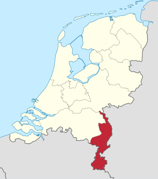
Limburg is the southernmost of the twelve provinces of the Netherlands. It is bordered by Gelderland to the north and by North Brabant to its west. Its long eastern boundary forms the international border with the state of North Rhine-Westphalia in Germany. To the west is the international border with the similarly named Belgian province of Limburg, part of which is delineated by the river Meuse. The Vaalserberg is on the extreme southeastern point, marking the tripoint of the Netherlands, Germany and Belgium.

<span class="mw-page-title-main">Heerlen</span> City and municipality in Limburg, Netherlands

Heerlen is a city and a municipality in the southeast of the Netherlands. It is the third largest settlement proper in the province of Limburg. Measured as municipality, it is the fourth municipality in the province of Limburg.

<span class="mw-page-title-main">Simpelveld</span> Municipality in Limburg, Netherlands

Simpelveld is a municipality and a town in the southeastern Netherlands. It is part of the municipal cooperative unit Parkstad Limburg.

<span class="mw-page-title-main">Eygelshoven</span> Neighbourhood and former village in Kerkrade, Limburg, Netherlands

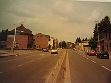
Eygelshoven is a village, since 1982 part of the town of Kerkrade, in the southeast of the Netherlands, close to the German and Belgian borders.

<span class="mw-page-title-main">Limburgish</span> Low Franconian language spoken in the provinces of Limburg

Limburgish, also called Limburgan, Limburgian, or Limburgic, is a West Germanic language spoken in the Dutch and Belgian provinces of Limburg and in the neighbouring regions of Germany.

<span class="mw-page-title-main">Ripuarian language</span> German dialect group

Ripuarian is a German dialect group, part of the West Central German language group. Together with the Moselle Franconian which includes the Luxembourgish language, Ripuarian belongs to the larger Central Franconian dialect family and also to the Rhinelandic linguistic continuum with the Low Franconian languages.

<span class="mw-page-title-main">Herzogenrath</span> Town in North Rhine-Westphalia, Germany

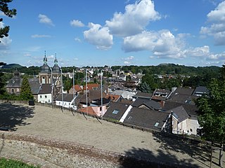
Herzogenrath is a municipality in the district of Aachen in the German state of North Rhine-Westphalia. It borders the Dutch town of Kerkrade, the national border in one section running along the middle of a main road and even directly through the centre of the cross-border Eurode office complex.

<span class="mw-page-title-main">Duchy of Limburg</span> Duchy of the Low Countries (1065–1795)

The Duchy of Limburg or Limbourg was an imperial estate of the Holy Roman Empire. Much of the area of the duchy is today located within Liège Province of Belgium, with a small portion in the municipality of Voeren, an exclave of the neighbouring Limburg Province. Its chief town was Limbourg-sur-Vesdre, in today's Liège Province.

<span class="mw-page-title-main">Rolduc</span> Monastery in Kerkrade, Netherlands

Rolduc is the name of a medieval abbey located on the edge of the town of Kerkrade in the far south-east of the Netherlands. It is today a Roman Catholic seminary with an affiliated conference center. The abbey is a rijksmonument. It features on the official list of 100 top Dutch heritage sites, drawn up in 1990 by what is today the Rijksdienst voor het Cultureel Erfgoed.

<span class="mw-page-title-main">Bocholtz</span> Town in Limburg, Netherlands

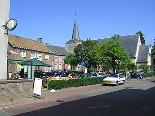
Bocholtz (Dutch pronunciation:[ˈbɔxɔlts]; Ripuarian: Bóches is a town in the Dutch province of Limburg. It is a part of the municipality of Simpelveld, and lies about 7 km southwest of Kerkrade. Until 1982, it was a separate municipality.

Parkstad Limburg is a conurbation of seven municipalities in the southern part of the province of Limburg in the Netherlands. Consisting of Heerlen, Kerkrade, Landgraaf, Brunssum, Simpelveld, Voerendaal and Beekdaelen, the municipalities work together to improve public services, transport and housing on a regional level. This collaboration started in 1999. Within Parkstad, the city of Heerlen functions as the centre of economic and social activity, and to a lesser extent the cities Kerkrade and Landgraaf function in the same regard as regional hubs.

Southeast Limburgish is a cover term for the Ripuarian dialects spoken in Dutch Limburg.

<span class="mw-page-title-main">Languages of the Netherlands</span>

The predominant language of the Netherlands is Dutch, spoken and written by almost all people in the Netherlands. Dutch is also spoken and official in Aruba, Bonaire, Belgium, Curaçao, Saba, Sint Eustatius, Sint Maarten and Suriname. It is a West Germanic, Low Franconian language that originated in the Early Middle Ages and was standardised in the 16th century.

Dutch dialects are primarily the dialects that are both cognate with the Dutch language and spoken in the same language area as the Dutch standard language. They are remarkably diverse and are found within Europe mainly in the Netherlands and northern Belgium.

<span class="mw-page-title-main">Meuse–Rhine Euroregion</span> Region of Belgium, Germany and Netherlands

The Meuse–Rhine Euroregion is a Euroregion created in 1976, with judicial status achieved in 1991. It comprises 11.000 km2 and has around 3.9 million inhabitants around the city-corridor of Aachen–Maastricht–Hasselt–Liège. The seat of the region has been in Eupen, Belgium since 1 January 2007. Within a wider context, the region is part of what is called the Blue Banana European urbanisation corridor.

Hard and soft G in Dutch refers to a phonetic phenomenon of the pronunciation of the letters ⟨g⟩ and ⟨ch⟩ and also a major isogloss within that language.

<span class="mw-page-title-main">Eijsden-Margraten</span> Municipality in Limburg, Netherlands

Eijsden-Margraten (Dutch pronunciation:[ˌɛizdəˈmɑrɣraːtə ]; is a municipality situated in the very south of the Netherlands. There it is located in the southeastern part of the province of Limburg.

<span class="mw-page-title-main">Neustraße/Nieuwstraat (Herzogenrath/Kerkrade)</span>

Kerkrade dialect is a Ripuarian dialect spoken in Kerkrade and its surroundings, including Herzogenrath in Germany. It is spoken in all social classes, but the variety spoken by younger people in Kerkrade is somewhat closer to Standard Dutch.

This article covers the phonology of the Kerkrade dialect, a West Ripuarian language variety spoken in parts of the Kerkrade municipality in the Netherlands and Herzogenrath in Germany.

References

  1. "Het college" [The board of mayor and aldermen] (in Dutch). Gemeente Kerkrade. Archived from the original on 2013-10-07. Retrieved 29 October 2013.
  2. "Kerncijfers wijken en buurten 2020" [Key figures for neighbourhoods 2020]. StatLine (in Dutch). CBS. 24 July 2020. Retrieved 19 September 2020.
  3. "Postcodetool for 6461EC". Actueel Hoogtebestand Nederland (in Dutch). Het Waterschapshuis. Archived from the original on 21 September 2013. Retrieved 29 October 2013.
  4. "Bevolkingsontwikkeling; regio per maand" [Population growth; regions per month]. CBS Statline (in Dutch). CBS. 1 January 2021. Retrieved 2 January 2022.
  5. 1 2 3 4 5 Jan Buursink and Nicole Ehlers, "The Binational City of Eurode" Archived 2020-11-24 at the Wayback Machine . University of Nijmegen.
  6. Stenvert, R. et al. (2003). Monumenten in Nederland: Limburg, p. 173–178. Zwolle: Waanders Uitgevers. ISBN   90-400-9623-6.
  7. "The coal mines: Limburg's 'black gold' - The Memory". geheugen.delpher.nl. Retrieved 2022-08-05.
  8. "World's Most Unique Cities". Toronto Star , June 2, 2016.
  9. "Neue Anlaufstelle für Grenzpendler in der Euregio" Archived 2017-02-23 at the Wayback Machine . Aachener Zeitung , September 6, 2016.
  10. "World Music Contest opens in Kerkrade". Radio Netherlands Worldwide. 12 July 2009. Archived from the original on 2012-10-17. Retrieved 22 August 2011.
  11. "1899-1962 Pater Leonardus Josephus Weidmann" (in Dutch). Archived from the original on 2005-02-20. Retrieved 16 May 2021.
  12. IMDb Database retrieved 16 January 2020

Commons-logo.svg Media related to Kerkrade at Wikimedia Commons