
Junagadh is the city and headquarters of Junagadh district in the Indian state of Gujarat. Located at the foot of the Girnar hills, 355 kilometres (221 mi) southwest of Ahmedabad and Gandhinagar, it is the seventh largest city in the state.
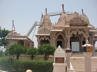
Vataman or Vataman Chowkdi is a small village in the western state of Gujarat in India, located at a crossroads about an hour and a half from Ahmedabad or Amdavad airport on the road to Palitana. Vataman is famous for its Jain derasar. Vataman village is famous for guava fruit many cast of people live in vataman like rajput, garasiya, Koli patel, bharavad, etc. The cast of Rajputs are Barad, Dabhi, Rathod, Parmar, Chavda, etc. The cast of Garasiya Rajputs are Gohil, Zala Jadeja. Vataman village is also famous for temples like Ranmukteshwar Mahadev temple, Swaminarayan temple, Ramji Mandir, Laghurajswami temple, Bhathavali Meldi Maa temple etc. and Khedut Bazar mini mall(agro) also situated at Vataman Chowkadi by Hathisang Bhikhubha Barad and Barad Krupalsinh Hathisang.

Sabarkantha district is one of the 33 districts of Gujarat state of India, located in the northeastern part of the state. The administrative headquarters of the district are located in Himatnagar.

Mehsana, also spelled Mahesana, is a city and the headquarters of Mehsana district in the Indian state of Gujarat. Established in 14th century, the city was under Gaekwads of Baroda State from 18th century to the independence of India in 1947. Dairy, oil and natural gas are major industries in the city.

Palanpur is a city and a headquarters of Banaskantha district in the Indian state of Gujarat. Palanpur is the ancestral home to an industry of Indian diamond merchants.

Anand District is an administrative district of Gujarat state in western India and whose popular nickname is Charotar. It was carved out of the Kheda district in 1997. Anand is the administrative headquarters of the district. It is bounded by Kheda District to the north, Vadodara District to the east, Ahmedabad District to the west, and the Gulf of Khambhat to the south. Major towns are Umreth, Khambhat, Karamsad, Tarapur, Petlad, Borsad and Sojitra.
Patidar, formerly known as Kanbi, is an Indian land-owning and peasant caste and community native to Gujarat. The community comprises at multiple subcastes, most prominently the Levas and Kadvas. They form one of the dominant castes in Gujarat. The title of Patidar originally conferred to the land owning aristocratic class of Gujarati Kanbis; however, it was later applied en masse to the entirety of the Kanbi population who lay claim to a land owning identity, partly as a result of land reforms during the British Raj.
Chanasma is a small town and a municipality in Chanasma Taluka of Patan district in the state of Gujarat, India. Chanasma is a seat of Gujarat Assembly. The MP seat of Chanasma falls in the Patan Lok Sabha. Chanasma village is connected by Kandla-Mehsana highway. And since the broad gauge of the railway is being renovated, it is going to connect with Rajasthan via Patan from Ahmedabad. Patel, Brahmin, Vania, Darji, Panchal, Parmar, Rabari, Thakor, Nayi, all communities live in Chansma village. The old village of Chanasma was between Ugmano Darwaza and Athamano Darwaza. But now due to the increase in population and development of the village, the village is spreading to the outside. Chansma Village Shree Laljidas Laxmidas Patel Trust runs Rotla Ghar for feeding the poor where clean and nutritious meals are provided to the poor for free.
Tharad is a town in Tharad taluka in the Banaskantha district of the state of Gujarat in India. It is the administrative center of Tharad taluka. Tharad is near the border of Gujarat, 40 km from the border with Pakistan and 15 km from the Indian state of Rajasthan. Its main industries are agriculture and diamond polishing. It is one of the first major towns in Gujarat on National Highway 15.
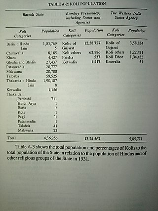
The Koli is a caste of India, Pakistan and Nepal which is mostly found in the Indian States of Gujarat, Maharashtra, Himachal Pradesh and Sindh province of Pakistan. Koli rebellion also known as Koli revolt, Koli raising, Koli uprising, Koli Insurrection, and Koli mutiny. Here are a series of revolts of Koli caste in inhabited areas.

The Babi dynasty was a Pashtun dynasty that formed the ruling royal houses of various kingdoms and later princely states. The Babai community, originally of Afghan descent, largely resides in India and some parts of Pakistan. The community traces its royal origins to the dynasty founded by Sherkhanji Babi in 1654, who was himself a ruler from the dynasty's founding until 1690. The last Nawab of the British Indian princely state of Junagadh, Sir Muhammad Khanji, signed an Instrument of Accession and acceded his princely state of Junagadh, as well as its vassal state of sardargadh, Bantva Manavadar, to the Dominion of Pakistan after the Partition of British India in 1947. However, the Dominion of India did not recognize the accession and annexed the princely state shortly afterwards.

Bhat is a village in Daskroi Taluka in Ahmedabad district of Gujarat State, India. Bhat is located near the bank of the Sabarmati River, 24 km towards west from District headquarters Ahmedabad, 5 km from Daskroi and 49 km from State capital Gandhinagar.
The history of Palanpur starts with its relation to the historic city of Chandravati ruled by Paramara dynasty. The town was re-peopled and ruled by Chauhans around thirteenth century. At the start of the seventeenth century, the Palanpur State was taken over by Jhalori dynasty of Pashtun Lohani (Bihari-Pathan) tribe which was founded in 1373 and ruled from Jhalor. The dynasty came into historical prominence during the period of instability that followed the demise of Mughal Emperor Aurangzeb in the early 18th century. It was overrun soon afterwards by the Marathas; the Lohanis followed the trend of seeking recourse in the British East India Company against them and finally entered the subsidiary alliance system in 1817, along with all other neighbouring states, becoming a British protectorate governed by Palanpur Agency. After independence of India in 1947, Palanpur State was dissolved in 1949 and merged with India as a part of Bombay State. Subsequently, Palanpur became the capital of Banaskantha district of Gujarat.(Hebatpur) Currently Maximum Jagirdar Families Living In Hebatpur Village:12 Km Away From Palanpur. In Addition:5 Villages Lohani Family. 42 Villages Bihari Families. Also Pathan & Ghori Families.
Radhanpur is a town and a municipality in Patan district in the Indian state of Gujarat. Radhanpur belonged to the Vaghelas in early years and later it was held as a fief under the Gujarat Sultanate by Fateh Khan Baloch. During Mughal period, the descendants of Babi dynasty were appointed as the governor of Radhanpur and other villages of North Gujarat. After decline of Mughal, they became free and established themselves as independent rulers. In 1743, Babi descendant Jawan Mard Khan II took over viceroyalty of Ahmedabad and controlled several villages in North Gujarat. He was defeated by Maratha Gaekwads in 1753 at Ahmedabad and Gaekwads agreed to his demand of control of villages in North Gujarat headquartered at Radhanpur State. His descendants lost some of these villages to Gaekwads subsequently. In 1813, Sher Khan made a treaty with the Gaekwar and British and became British protectorate. His descendants ruled the state until independence of India in 1947.
Katosan is a town and former Princely State in Jotana Taluka of Mehsana district, Gujarat, India.
Mahemadavad Kheda Road railway station is a railway station on the Western Railway network in the state of Gujarat, India. Mahemadavad Kheda Road railway station is 18 km far away from Nadiad railway station. Passenger, MEMU and few Express/Superfast trains halt at Mahemadavad Kheda Road railway station. This railway station's nearest city is Kheda.
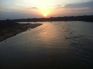
The Vatrak is a tributary of the Sabarmati River which flows for 243 kilometers in Gujarat, India. It originates in the hills of Dungarpur, Rajasthan and enters in Gujarat near village Moydi of Meghraj taluka.

Vautha fair is one of the important fairs held in Gujarat. Vautha is located on the border of Dholka taluka of Ahmedabad district and Matar taluka of Kheda district. Vautha fair is the largest fair in Ahmedabad district.
The Chunvalia, or Chuvalia, Chunwalia is a subcaste of the Koli caste, found in the Indian state of Gujarat. The Chunvalia Kolis were the first Indian caste to adopt the game of cricket in India. Chunvalia Kolis were classified as a Criminal Tribe under Criminal Tribes Act by government of the British Raj because of their purported anti-social behaviour and activities, such as alleged dacoity in Gujarat. During the First World War, Chunwalia Kolis were enlisted as soldiers in British Indian Army by the Bombay government of British India.
The Talapada, or Talpada, is a subcaste of the Koli caste of Gujarat state in India. Talapada Kolis are agriculturists by profession. they were members of the Gujarat Kshatriya Sabha, an organisation launched by Natwarsinh Solanki who was a Koli elite. In 1907, they were classified by the British as a Criminal Tribe, ascribing to them a range of anti-social activities such as highway robbery, murder, and theft of animals, cattle and standing crops. They were also alleged to be blackmailers and hired assassins.

