Khrustalnyi

Last updated
Khrustalnyi
Хрустальний (Ukrainian)
City
Executive Committee building in Khrustalnyi.jpg
Executive Committee building in Khrustalnyi
Flag of Krasnyi Luch, Ukraine.svg
Gerb Krasnogo Lucha.png
Lugansk Oblast location map.svg
Red pog.svg
Khrustalnyi
Location in Luhansk Oblast
Ukraine under russian occupation grey.svg
Red pog.svg
Khrustalnyi
Location in Ukraine
Coordinates: 48°08′N38°56′E / 48.133°N 38.933°E / 48.133; 38.933
Country Flag of Ukraine.svg  Ukraine
Oblast Luhansk Oblast
Raion Rovenky Raion
Hromada Khrustalnyi urban hromada
Founded1880s
Area
15,356 km2 (5,929 sq mi)
Elevation
269 m (883 ft)
Population
 (2022)
79,533
Time zone UTC+2 (EET)
  Summer (DST) UTC+3 (EEST)
Climate Dfb

Khrustalnyi [lower-alpha 1] or Krasnyi Luch [lower-alpha 2] is a city in Luhansk Oblast, eastern Ukraine. Its population is approximately 79,533 (2022 estimate). [1] It has historically been one of the most important coal mining locations in the Donbas region.

Contents

The city was founded in the 1880s after the discovery of coal deposits in the region, and grew over the following century. Until 1920, it was known as Kryndachivka, after the surname of an early settler. [lower-alpha 3] It was a site of fighting during World War II. Since the beginning of the Russo-Ukrainian War in 2014, it has been occupied by the widely unrecognized Luhansk People's Republic and later by Russia after its Annexation on 30 September 2022.

History

Russian Empire

The city was founded as a mining site named Kryndachivka in the 1880s in the Russian Empire. [2] The foundation of the site was because of the recent discovery of rich coal deposits in the region. The original name of the city was derived from the name of the man who owned the land, 'Kryndach'. A village grew up around the mining site and rail station. [3]

The first three major mines at the location were built in 1900–1903. At the time, there was a growing demand for coal due to rapid industrialization in the Russian Empire, especially in the southern parts near Kryndachivka. [3] Kryndachivka became one of the most important coal mining centres of the Donbas. [2] [4] However, according to official Soviet sources written after the fact, working conditions were extremely brutal for workers in the mines, who were impoverished and lived in terrible conditions. There were mass demonstrations of workers in 1905, but the mine owners refused to meet the demands of the strikers, deploying Cossacks to disperse the workers with military force. [3]

A single school opened in Kryndachivka in 1906. However, other than this, official Soviet historical sources describe Kryndachivka as a "small and dirty village" on the eve of World War I. There was reportedly no hospital, and residents had to walk long distance for drinkable water. Most residents lived in adobe shacks and dugouts. It had a population of 3,500 by 1913. During the beginning of World War I proper, there were anti-war rallies and protests in the village, with workers refusing to go to the front and clashing with Tsarist authorities. The economic situation worsened during the war, with wages being cut and food prices going up. There was another strike in early 1916 where workers demanded better conditions, but according to Soviet sources it was brutally suppressed, with six workers being jailed and 350 sent to the front. [3]

In the February Revolution of 1917, the Tsar was overthrown, causing more pro-worker unrest in Kryndachivka. During the ensuing Russian Civil War, Alexey Kaledin of the anti-Bolshevik White movement deployed his armed Don Cossacks to the Donbas, but was unable to control the mines due to local resistance, according to Soviet sources. Continued violence took place in the village throughout the civil war. In May 1918, during the Central Powers invasion of Ukraine, Kryndachivka was occupied by the Central Powers, further damaging the village's economy. By the end of that year, the Central Powers were expelled, but continued violence in the civil war took place, with the village changing hands several times until the final Bolshevik victory, and the establishment of the communist Soviet Union on the former territories of the Russian Empire. [3]

Soviet Union

The local economy slowly recovered after the end of the fighting. [3] A local newspaper began being published in Kryndachivka in September 1920. [5] In December 1920 the village was renamed to Krasnyi Luch (lit.'"red ray", or "red beam"'). [4] [6] The settlement continued to grow, receiving city status in 1926, [2] at which time it had a population of 12,425. Infrastructure was built, including hospitals and schools. By 1941, the population had grown to 55,000 - 16 times the population in 1913. [3]

The Mius-Front monument [uk] in the city Mius-front, monument na gori.jpg
The Mius-Front monument  [ uk ] in the city

During World War II, Nazi Germany launched a massive invasion of the Soviet Union. German forces heavily shelled Krasnyi Luch, but were stopped 6 kilometres (3.7 mi) from the city, at the river Mius. Fierce battles took place on the approach to Krasnyi Luch, reportedly holding off the Germans for eight months. The Mius-Front monument  [ uk ] has since been installed in the city, to commemorate the brave defense of the city. [7]

However, in summer 1941, the German forces launched a new offensive, and captured the city on 18 June 1942. [7] The local Jewish population was murdered by the Nazis along with other categories of victims, such as Communists, and were thrown into the shaft of the Bogdan coal mine. The total number of victims was about 2,000. [8] On August 1, 1943, the well-known WWII fighter pilot Lydia Litvyak took off from a base at Krasnyy Luch, to the last mission from which she never came back.[ citation needed ]

Krasnyi Luch was liberated by the 51st Army of the Southern Front of the Red Army on 1 September 1943. [7] [4] The Nazis mostly destroyed the city behind them as they left. By the end of the occupation, the population was only 11,400, a fifth of the pre-war numbers. The infrastructure was slowly rebuilt after the end of the occupation. [7]

A coat of arms was adapted in 1978. [9] In January 1989, the city population was 113,278 people. [10] Krasnyi Luch remained an important coal-mining centre. [6] There were several coal-enriching plants, a machine-tool factory, light industries and a railway station. [2]

Independent Ukraine

Ukraine declared independence in 1991 during the disintegration of the Soviet Union. [11] On 21 April 2004, a new flag was adopted for the city, featuring the blue and yellow bicolor of the Ukrainian flag with imagery of red rays of the sun, gears, and coal superimposed on top. [12]

Russo–Ukrainian War

The variation of the flag used by the Luhansk People's Republic Flag of Krasnyi Luch (LPR-recognized).svg
The variation of the flag used by the Luhansk People's Republic

During the war in Donbas that began in 2014, Krasnyi Luch fell into the control of the Luhansk People's Republic (LPR), a Russian-led separatist group. [13] The city was reportedly bombed in January 2015 during the battle of Debaltseve. [13] The city's hospital was also used by LPR militants who fought in the battle. [14] Reportedly, Evangelical Christians and other minority Christian denominations in Krasnyi Luch and other cities in Russian-occupied Ukraine were "terrorized" by pro-Russian gunmen throughout 2014 and 2015. [15]

On 12 May 2016, the Ukrainian parliament renamed the city from Krasnyi Luch to Khrustalnyi under Ukrainian decommunization laws. [16] However, the occupying separatists have continued to use the old communist name. [17] Additionally, because the normal flag of the city contains the Ukrainian colors, the LPR authorities have used a variant flag of their own design in which the Ukrainian bicolor is replaced by the colors of the flag of the Luhansk People's Republic. [18]

In accordance with administrative reforms in Ukraine in 2020, Khrustalyni was officially designated by the Ukrainian government to Khrustalnyi urban hromada in Rovenky Raion. However, the LPR - and later explicitly Russia - has never recognized the Ukrainian government's authority over the area, and consider the city to be part of the urban okrug Krasnyi Luch. [19]

During the 2022 Russian invasion of Ukraine, the city was subject to a Ukrainian Tochka-U ballistic missile strike on 16 June 2022 that caused a large Russian ammunition depot belonging to the 2nd Army Corps to detonate. [20] [ better source needed ] Footage of the attack was uploaded to social media where a group of Luhansk People's Republic militiamen are seen to be sheltering and fleeing from the ensuing ammunition fire. [21] [ better source needed ] On the night of 23–24 July 2022, Ukrainian intelligence reported another strike by the Ukrainian Armed Forces on a hotel that was being used as a base by Russian soldiers, reportedly killing 100 of them. [22] On 30 September 2022, Russia unilaterally declared its annexation of areas in Luhansk Oblast.[ citation needed ]

Demographics

Historical population
YearPop.±%
1913 3,500 [3]     
1926 12,425 [7] +255.0%
1941 55,000 [7] +342.7%
1943 11,400 [7] −79.3%
1965 101,000 [23] +786.0%
YearPop.±%
1972 103,000 [24] +2.0%
1989 113,278 [10] +10.0%
2013 82,765 [25] −26.9%
2022 79,533 [1] −3.9%

As of the Ukrainian Census of 2001, the ethnicities and languages of the population were: [26]

Ethnicity
Language

Notable people

Notes

  1. Ukrainian: Хрустальний; Russian: Хрустальный
  2. Ukrainian: Красний Луч; Russian: Красный Луч
  3. Ukrainian: Криндачівка; Russian: Криндачёвка, romanized: Krindachyovka

Related Research Articles

<span class="mw-page-title-main">Sverdlovsk, Ukraine</span> City in Luhansk Oblast, Ukraine

Sverdlovsk or Dovzhansk is an industrial city in Luhansk Oblast of Ukraine, near the internationally recognized border with Russia. This is the residence of Dovzhansk urban hromada and Dovzhansk Raion (district). It is located approximately 80 kilometres (50 mi) from the administrative center of the oblast, Luhansk. Its population is estimated to be 62,691.

<span class="mw-page-title-main">Luhansk Oblast</span> Administrative region of Ukraine

Luhansk Oblast, also referred to as Luhanshchyna (Луганщина), is the easternmost oblast (province) of Ukraine. Its administrative center is the city of Luhansk. The oblast was established in 1938 and bore the name Voroshilovgrad Oblast until 1958 and again from 1970 to 1991. It has a population of 2,102,921.

<span class="mw-page-title-main">Donbas</span> Region in eastern Ukraine

The Donbas or Donbass is a historical, cultural, and economic region in eastern Ukraine. Parts of the Donbas are occupied by Russia as a result of the Russo-Ukrainian War.

<span class="mw-page-title-main">Krasnodon</span> City in Luhansk Oblast, Ukraine

Krasnodon or Sorokyne is a city in Dovzhansk Raion (district) of Luhansk Oblast in Ukraine. Residence of Sorokyne urban hromada. Its population is approximately 42,315.

<span class="mw-page-title-main">Kadiivka</span> City in Luhansk Oblast, Ukraine

Kadiivka or Stakhanov, is a city in Alchevsk Raion, Luhansk Oblast, Donbas, eastern Ukraine. Residence of Kadiivka urban hromada. It is located on the Komyshuvakha River, a right tributary of the Luhan. Ukraine renamed the city Kadiivka in 2016, and refers to the city by this name, however Ukraine has not controlled the city since early 2014.

<span class="mw-page-title-main">Pervomaisk, Luhansk Oblast</span> City in Luhansk Oblast, Ukraine

Pervomaisk is a city in Kadiivka urban hromada, Alchevsk Raion (district), Luhansk Oblast (region), Ukraine, on the left bank of the Luhan River. Pervomaisk is 71 kilometres (44 mi), by road, from Luhansk, 133 kilometres (83 mi) from Izvarino, where there is the de jure international border between Ukraine and Russia, and 736km from Kyiv.

<span class="mw-page-title-main">Brianka</span> City in Luhansk Oblast, Ukraine

Bryanka is a city in Kadiivka urban hromada, Alchevsk Raion (district), Luhansk Oblast (region), Ukraine. It is located in the Donbas region, between the cities of Kadiivka and Alchevsk. Brianka is incorporated as a city of oblast significance. The population: 44,760,47,512 (2013 est.).

<span class="mw-page-title-main">Toretsk</span> City in Donetsk Oblast, Ukraine

Toretsk is an industrial city in Bakhmut Raion, Donetsk Oblast, Ukraine. It is the administrative center of Toretsk urban hromada, one of the hromadas of Ukraine. As of January 2022, its population was approximately 30,914.

<span class="mw-page-title-main">Debaltseve</span> City in Donetsk Oblast, Ukraine

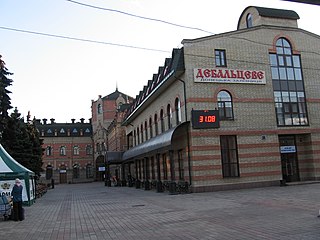
Debaltseve or Debaltsevo is a city in Horlivka Raion, Donetsk Oblast, Ukraine, currently occupied by Russia as part of the Donetsk People's Republic. The city is situated on the eastern edge of Donetsk Oblast, and borders Luhansk Oblast. Population: 24,209.

<span class="mw-page-title-main">Lyman, Ukraine</span> City in Donetsk region of Ukraine

Lyman, formerly known as Krasnyi Lyman from 1925 to 2016, is a city in Donetsk Oblast, Ukraine. Until 2016, it also served as the administrative center of Lyman Raion, though administratively it was not part of the raion and incorporated as a city of oblast significance. It still serves as the administrative center of Lyman urban hromada. The population was 20,066, down from 28,172 in 2001.

<span class="mw-page-title-main">Popasna</span> City in Luhansk Oblast, Ukraine

Popasna is a city in Sievierodonetsk Raion, Luhansk Oblast, Ukraine. It is the administrative center of Popasna urban hromada, one of the hromadas of Ukraine. In 2018, it was estimated that it had a population of 20,600 people.

<span class="mw-page-title-main">Voznesenivka</span> City in Luhansk Oblast, Ukraine

Voznesenivka or Chervonopartyzansk is a city in Dovzhansk urban hromada, Dovzhansk Raion (district) of Luhansk Oblast in Ukraine. Population: 15,218.

<span class="mw-page-title-main">Petrovske</span> City in Luhansk Oblast, Ukraine

Petrovske or Petrovo-Krasnosillia is a city in Khrustalnyi urban hromada, Rovenky Raion, Luhansk Oblast (region) of Ukraine, currently occupied by Russia. It has a population of 12,642.

<span class="mw-page-title-main">Vakhrusheve</span> City in Luhansk Oblast, Ukraine

Vakhrusheve or Bokovo-Khrustalne is a city in Khrustalnyi urban hromada, Rovenky Raion, Luhansk Oblast (region) of Ukraine, currently occupied by Russia. Population: 11,421 , 11,878 (2013 est.).

<span class="mw-page-title-main">Hirske</span> City in Luhansk Oblast, Ukraine

Hirske is a city in Sievierodonetsk Raion, Luhansk Oblast, eastern Ukraine. It is the administrative center of Hirske urban hromada, one of the hromadas of Ukraine. Its population is 9,100.

<span class="mw-page-title-main">Rovenky</span> City in Luhansk Oblast, Ukraine

Rovenky is a coal mining city in Rovenky Raion, Luhansk Oblast (region), Ukraine. Residence of Rovenky urban hromada. Prior to 2020, it was incorporated as a city of oblast significance. Population: 45,514 ;47,852 (2013 est.). Including the surrounding villages, the total population is close to 84,000.

Krasnyi Yar is a village in Molodohvardiisk urban hromada, Luhansk Raion, Luhansk Oblast (region), Ukraine, at about 30 km SE from the centre of Luhansk city.

Novoaidar is a rural settlement in Shchastia Raion, Luhansk Oblast, in the Donbas region of eastern Ukraine. Resirence of Novoaidar settlement hromada. Novoaidar is 57km, by road from regional centre Luhansk, 43km from Sieverodonetsk, and 747km from Kyiv. Novoaidar is located on the river Aidar, and is on Highway H21, which runs from Donetsk to Starobilsk.

Lypske or Krasnyi Oktiabr is a rural settlement in Makiivka urban hromada, Donetsk Raion in Donetsk Oblast of Ukraine. Population: 886.

FC Shakhtar Krasnyi Luch was a professional Ukrainian and Soviet football club. It currently competes at amateur level playing in occupied area. The club is based in Krasnyi Luch (Khrustalny), Ukraine.

References

  1. 1 2 Чисельність наявного населення України на 1 січня 2022 [Number of Present Population of Ukraine, as of January 1, 2022](PDF) (in Ukrainian and English). Kyiv: State Statistics Service of Ukraine. Archived (PDF) from the original on 4 July 2022.
  2. 1 2 3 4 "Krasnyy Luch". Encyclopedia Britannica. Retrieved 2023-09-15.
  3. 1 2 3 4 5 6 7 8 "Красний Луч, Луганська область" (in Ukrainian). Retrieved 2023-09-15.
  4. 1 2 3 Красный Луч // Большая Российская Энциклопедия / редколл., гл. ред. Ю. С. Осипов. том 15. М., научное издательство "Большая Российская Энциклопедия", 2010. стр.647
  5. № 2904. Знамя коммунизма // Летопись периодических и продолжающихся изданий СССР 1986 - 1990. Часть 2. Газеты. М., «Книжная палата», 1994. стр.381
  6. 1 2 Красный Луч // Большой энциклопедический словарь (в 2-х тт.). / редколл., гл. ред. А. М. Прохоров. том 1. М., "Советская энциклопедия", 1991. стр.648[ full citation needed ]
  7. 1 2 3 4 5 6 7 "Красний Луч, Луганська область (продовження)" [Krasnyi Luch, Luhansk Oblast (continued)] (in Ukrainian). Retrieved 2023-09-15.
  8. "YAHAD - IN UNUM". yahadmap.org. Retrieved 11 April 2018.
  9. "Khrustal'nyi: The soviet emblem". Ukrainian heraldry. Retrieved 2023-09-15.
  10. 1 2 "Всесоюзная перепись населения 1989 г. Численность городского населения союзных республик, их территориальных единиц, городских поселений и городских районов по полу".
  11. Ukraine and Russia: The Post-Soviet Transition Archived 2022-02-26 at the Wayback Machine by Roman Solchanyk, Rowman & Littlefield Publishers, 2000, ISBN   0742510182 (page 100)
    Canadian Yearbook of International Law, Vol 30, 1992 Archived 2022-02-26 at the Wayback Machine , University of British Columbia Press, 1993, ISBN   9780774804387 (page 371)
    Russia, Ukraine, and the Breakup of the Soviet Union Archived 2022-03-08 at the Wayback Machine by Roman Szporluk, Hoover Institution Press, 2000, ISBN   0817995420 (page 355)
  12. "Khrustal'nyi: the flag". Ukrainian heraldry. Retrieved 2023-09-15.
  13. 1 2 "Video: The fight to defend Ukraine's strategic Debaltseve". 2015-01-23. Retrieved 2023-09-15.
  14. "Rebels Suffer Heavy Losses in Battle for Ukraine's Debaltseve". 2015-01-31. Retrieved 2023-09-15.
  15. "Report says Christians persecuted in Donetsk and Luhansk" . Retrieved 2023-09-15.
  16. "Rada renames some population areas in occupied Donbas as part of decommunization campaign".
  17. "В ЛНР отвергают затею Киева с переименованиями городов | Журналистская Правда". 2016-02-20. Archived from [jpgazeta.ru/v-lnr-otvergayut-zateyu-kieva-s-pereimenovaniyami-gorodov/ the original] on 3 July 2023.{{cite web}}: Check |url= value (help)
  18. "Флаг красного луча". www.vexillographia.ru. Archived from the original on 2021-12-18. Retrieved 2022-05-11.
  19. "Закон Луганской Народной Республики от 14 марта 2023 года № 427-III «Об административно-территориальном устройстве Луганской Народной Республики»" (PDF) (in Russian). Luhansk People's Republic. Retrieved 2023-10-09.
  20. Dmitri (2022-06-19). "New details emerged of the Kransyi Luch ammo stockpile attack. • WarTranslated - Dmitri Masinski". WarTranslated - Dmitri Masinski. Retrieved 2022-07-05.
  21. Красный Луч 16.06.22 , retrieved 2022-07-05
  22. "Ukrainian Armed Forces kill 100 Russian soldiers in a hotel in Krasnyi Luch" . Retrieved 2023-09-15.
  23. В. П. Коленский. Красный Луч: путеводитель. Донецк, "Донбасс", 1966. стр.4
  24. "Красный Луч (город в Ворошиловградской обл.)". Great Soviet Encyclopedia (in Russian).
  25. "Чисельність наявного населення України на 1 січня 2013 року. Державна служба статистики України. Київ, 2013. стор.73" (PDF). Archived from the original (PDF) on 2013-10-12. Retrieved 2019-06-10.
  26. "Офіційна сторінка Всеукраїнського перепису населення". www.ukrcensus.gov.ua. Retrieved 11 April 2018.
  27. "I am Russian but competitor for Ukraine". m.sovsport.ru/. Archived from the original on December 22, 2015. Retrieved 23 August 2015.