Related Research Articles

Selkirkshire or the County of Selkirk is a historic county and registration county of Scotland. It borders Peeblesshire to the west, Midlothian to the north, Roxburghshire to the east, and Dumfriesshire to the south. It derives its name from its county town, the royal burgh of Selkirk. The county was historically also known as Ettrick Forest.

Coldingham is a village and parish in Scottish Borders, on Scotland's southeast coastline, north of Eyemouth.

Tarbat is a civil parish in Highland, Scotland, in the north-east corner of Ross and Cromarty.

Caddonfoot is a village on the River Tweed, in the Scottish Borders area of Scotland, on the A707, near Galashiels.
Kilmuir is a former fishing village, located on the north eastern shore of Nigg Bay, one mile southeast of Kildary and four miles northeast of Invergordon.
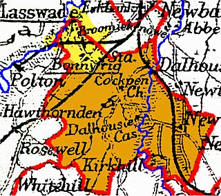
Cockpen is a parish in Midlothian, Scotland, containing at its north-west corner the town of Bonnyrigg, which lies two miles (3.2 km) south-west of Dalkeith. It is bounded on the west and north by the parish of Lasswade, on the east, by Newbattle and on the south by Carrington. It extends about three miles (4.8 km) from north to south and its greatest breadth is about 2+1⁄2 miles (4.0 km).
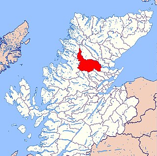
Resolis is a village and parish on the B9163 road, in the Black Isle in Scotland. It is part of the Presbytery of Ross. In 2011 it had a population of 362.

Scoonie is a settlement and parish in Fife, Scotland, the parish contains the town of Leven. It is bordered on the north by the parishes of Kettle and Ceres, on the east by the parish of Largo, on the south by the parishes of Markinch and Wemyss, and on the west by the parishes of Markinch and Kennoway. It extends about 4+1⁄2 miles north to south. Its width varies between 5⁄8 and 2+3⁄4 mi . The parish is on the coast of the Firth of Forth, with a coastline of about 1+1⁄2 mi (2.4 km) The area of the parish is 4,107 acres.
Largo is a parish in Fife, Scotland containing the villages of Upper Largo or Kirkton of Largo, Lower Largo and Lundin Links. It is bounded on the west by the parish of Scoonie, on the north by Ceres and on the east by the parishes of Newburn and Kilconquhar. It has a coastline of 2¾ miles along Largo bay. Inland it extends 3-4 ½ miles north from the south coast of Fife. Area 7,378 acres.
Mertoun is a parish in the south-west of the historic county of Berwickshire in the Scottish Borders area of Scotland. Together with the parish of Maxton, Roxburghshire it forms the Maxton and Mertoun Community Council area. It was included in the former Ettrick and Lauderdale District of Borders Region, by the Local Government (Scotland) Act 1973, from 1975 to 1996.

Cranston is a parish of Midlothian, Scotland, lying 4+1⁄4 miles south-east of Dalkeith. It is bounded by the parishes of Inveresk and Ormiston on the east, by Crichton and Borthwick on the south ; and by Newbattle on the west and north. The River Tyne flows through the centre of the parish.
Moonzie is a small parish in Fife, Scotland, about 3 miles north-west of Cupar. It is bounded on the west by Creich, on the north by Kilmany, on the south-east by Cupar and on the south-west by Monimail.

Abdie is a parish in north-west Fife, Scotland, lying on the south shore of the Firth of Tay on the eastern outskirts of Newburgh, extending about 3 miles eastwards to the boundary of Dunbog parish, with which it is now united ecclesiastically and for the Community Council. It is also bounded by Collessie on the south and has a small border with the parish of Moonzie in the south-east.

Cameron is a parish in east Fife, Scotland, 3½ miles south-west of St Andrews.
Logie is a parish and village in east Fife, Scotland, 5 miles north-east of Cupar.

Largoward is a village in East Fife, Scotland, lying on the road from Leven to St Andrews in the Riggin o Fife, 4½ miles north-east of Lower Largo and 6½ miles south-west of St Andrews. It is an agricultural and former mining village, one of the three main villages of the civil parish of Kilconquhar, along with Colinsburgh and the village of Kilconquhar. Coal must have been worked for a considerable length of time in the district, as it is recorded that coal was driven annually from Falfield, just north-west of the village, to Falkland Palace for the use of King James VI.
Manor is a parish in Peeblesshire in the Scottish Borders, whose church lies on the west bank of Manor Water 3 miles south-west of Peebles.

Broughton, Glenholm and Kilbucho is a parish in Peeblesshire in the Scottish Borders, 11 miles south-west of Peebles, lying in the upper part of the valley of the River Tweed in the Southern Uplands. It is a union of three former parishes of bearing these names and the united parish is bound by Kirkurd on the north, Stobo on the east, Drumelzier on the south-east, Culter and Biggar, South Lanarkshire on the west and by Skirling in the north-west. For 4½ miles the eastern border of the parish follows the northward flowing Tweed. It is 9½ miles long north-to-south and 3½ miles wide. The only village is Broughton.
Kincardine is a civil parish in the Scottish council area of Stirling and the former county of Perthshire in the historic district of Menteith.
Kincardine is an extensive civil parish and Community council area on the south side of the Kyle of Sutherland, within the Highland unitary authority area of Scotland, the largest settlement being Ardgay.
References
- 1 2 Ordnance Gazetteer of Scotland, by Francis H. Groome; publ. Thomas C. Jack, Edinburgh,1901. (Article on Kildonan); pp.921-922
- ↑ Census of Scotland 2011, Table KS101SC – Usually Resident Population, publ. by National Records of Scotland. Web site http://www.scotlandscensus.gov.uk/ retrieved April 2021. See "Standard Outputs", Table KS101SC, Area type: Civil Parish
- ↑ Census of Scotland 1931. Preliminary Report. Table 17 - Population and Acreage of Civil Parishes alphabetically arranged. Publ. H.M.S.O. 1931
- ↑ Community Councils website is managed on behalf of the Scottish Government www.communitycouncils.scot/community-council-finder Retrieved April 2021
| | This Scottish location article is a stub. You can help Wikipedia by expanding it. |