
The Seminole Wars were a series of three military conflicts between the United States and the Seminoles that took place in Florida between about 1816 and 1858. The Seminoles are a Native American nation which coalesced in northern Florida during the early 1700s, when the territory was still a Spanish colonial possession. Tensions grew between the Seminoles and settlers in the newly independent United States in the early 1800s, mainly because enslaved people regularly fled from Georgia into Spanish Florida, prompting slaveowners to conduct slave raids across the border. A series of cross-border skirmishes escalated into the First Seminole War in 1817, when General Andrew Jackson led an incursion into the territory over Spanish objections. Jackson's forces destroyed several Seminole and Black Seminole towns and briefly occupied Pensacola before withdrawing in 1818. The U.S. and Spain soon negotiated the transfer of the territory with the Adams-Onis Treaty of 1819.

St. Augustine is a city in the Southeastern United States and the county seat of St. Johns County on the Atlantic coast of northeastern Florida. Founded in 1565 by Spanish explorers, it is the oldest continuously inhabited European-established settlement in what is now the contiguous United States.

El Camino Real is the name that the Spanish gave to a trail they cleared in the 1680s, mostly over the traditional trails of Native Americans, from St. Augustine westward to the Spanish missions in north Florida. Before this time, transpeninsular traffic in La Florida between the western mission settlements and the capital depended on water routes from Apalachee to St. Augustine. Agricultural commodities produced in Apalachee were carried by canoes to the Gulf of Mexico and southward on the coast to the mouth of the Suwanee River, then upriver to a location on the Santa Fe River. There they were loaded onto pack animals or the backs of Indian burderners (porters) for the remainder of the overland trip. Provisions and funds from the real situado were sent on the same route in reverse.

East Florida was a colony of Great Britain from 1763 to 1783 and a province of Spanish Florida from 1783 to 1821. Great Britain gained control of the long-established Spanish colony of La Florida in 1763 as part of the treaty ending the French and Indian War. Deciding that the territory was too large to administer as a single unit, Britain divided Florida into two colonies separated by the Apalachicola River: East Florida with its capital in St. Augustine and West Florida with its capital in Pensacola. East Florida was much larger and comprised the bulk of the former Spanish territory of Florida and most of the current state of Florida. It had also been the most populated region of Spanish Florida, but before control was transferred to Britain, most residents – including virtually everyone in St. Augustine – left the territory, with most migrating to Cuba.

Patrick Tonyn (1725–1804) was a British General who served as the last British governor of East Florida, from 1774 to 1783. His governorship lasted the span of the American Revolution. East Florida was a Loyalist colony during the war.

Andrew Turnbull (1718–1792) was a Scottish physician who later served as a British Consul at Smyrna, then part of the Ottoman Empire, in what is now Turkey. In 1768, he organized the largest attempt at British colonization in the New World by founding New Smyrna, Florida, named in honor of his wife's birthplace, the ancient Greek city of Smyrna on the Aegean coast of Anatolia. Turnbull was married to Gracia Dura Bin, the daughter of a Greek merchant from Smyrna. His colony was located in the province of British East Florida, and encompassed some 101,400 acres (410 km2); it was nearly three times the size of the colony at Jamestown.
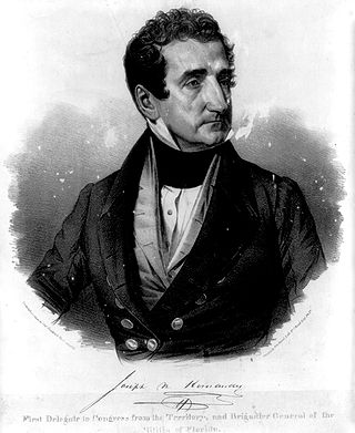
José Mariano Hernández or Joseph Marion Hernández was an American politician, plantation owner, and soldier. He was the first Delegate from the Florida Territory and the first Hispanic American to serve in the United States Congress. A member of the Whig Party, he served from September 1822 to March 1823.
Isaiah David Hart was an American plantation owner, and the founder of Jacksonville, Florida. Originally from Georgia, Hart took up arms against Spain in the Patriot Rebellion of 1812. After moving to a location near the cow ford on the narrows of the St. Johns River, he began platting the town in 1822, and later served as postmaster, court clerk, commissioner of pilotage, judge of elections, major in the local militia during the Seminole War, and as a Whig member of the Florida Territorial Senate. The Isaiah D. Hart Bridge over the St. Johns River in Jacksonville is named after him.

The Halifax River is part of the Atlantic Intracoastal Waterway, located in northeast Volusia County, Florida. The waterway was originally known as the North Mosquito River, but was renamed after George Montagu-Dunk, 2nd Earl of Halifax, during the British occupation of Florida (1763–1784).
Sawpit Bluff was a small settlement in East Florida during the American Revolutionary War, on the site of a plantation at the mouth of Sawpit Creek where it discharges into Nassau Sound opposite the south end of Amelia Island. It was the location of a proposed rendezvous between mounted militia from Sunbury, Georgia and Continental troops under the command of Lt. Col. Samuel Elbert during the second invasion of Florida in May 1777.
John Moultrie was an English politician who served as deputy governor of East Florida in the years before the American Revolutionary War. He became acting governor when his predecessor, James Grant, was invalided home in 1771 and held the position until 1774. Moultrie again became a deputy under his successor, Patrick Tonyn, returning to Great Britain in 1784.

Panton, Leslie & Company was a company of Scottish merchants active in trading in the Bahamas and with the Native Americans of what is now the Southeastern United States during the late 18th and early 19th centuries.
Francis Levett was an English trader, who worked as factor at Livorno, Italy, for the Levant Company until he lit out for East Florida in 1769 where his brother-in-law Patrick Tonyn of the British Army had been appointed governor of the English colony. Wielding connections from a lifetime of overseas trading, as well as family connections from a powerful English mercantile family, Levett built one of the first plantations in Florida, and then forfeited his investment when the English lost their foothold in Florida, forcing him to flee to the British colony in the Bahamas. Eventually his son returned to Georgia, where he became the first to plant Sea Island cotton in America.
Ahaya was the first recorded chief of the Alachua band of the Seminole tribe. European-Americans called him Cowkeeper, as he held a very large herd of cattle. Ahaya was the chief of a town of Oconee people near the Chattahoochee River. Around 1750 he led his people into Florida where they settled around Payne's Prairie, part of what the Spanish called tierras de la chua, "Alachua Country" in English. The Spanish called Ahaya's people cimarones, which eventually became "Seminoles" in English. Ahaya fought the Spanish, and sought friendship with the British, allying with them after Spain ceded Florida to Great Britain in 1763, and staying loyal to them through the American Revolutionary War. He died shortly after Britain returned Florida to Spain in 1783.
Uchee Billy or Yuchi Billy was a chief of a Yuchi band in Florida during the first half of the 19th century. Uchee Billy's band was living near Lake Miccosukee when Andrew Jackson invaded Spanish Florida during the First Seminole War and attacked the villages in the area. Yuchi Billy and his band then moved to the St. Johns River. During the Second Seminole War, Uchee Billy was an ally of the Seminoles, and was one of the principal war chiefs who fought the U.S. Army.

George J. F. Clarke was one of the most prominent and active men of East Florida during the Second Spanish Period. As a friend and trusted advisor of the Spanish governors of the province from 1811 to 1821, he was appointed to several public offices under the colonial regime, including that of surveyor general.
John Gordon was a Loyalist British merchant and trader of Scottish origin who lived in South Carolina for many years. He settled in Charles Town about 1760, and from 1759 to 1773 he was a major exporter of deerskins supplied by Native American hunters. Gordon also participated in the transatlantic slave trade but was not a major importer of captive Africans.
St. Augustine, Florida, the oldest continuously occupied settlement of European origin in the continental United States, was founded in 1565 by Spanish admiral Pedro Menéndez de Avilés. The Spanish Crown issued an asiento to Menéndez, signed by King Philip II on March 20, 1565, granting him various titles, including that of adelantado of Florida, and expansive privileges to exploit the lands in the vast territory of Spanish Florida, called La Florida by the Spaniards. This contract directed Menéndez to explore the region's Atlantic coast and report on its features, with the object of finding a suitable location to establish a permanent colony from which the Spanish treasure fleet could be defended and Spain's claimed territories in North America protected against incursions by other European powers.
John Forbes (1767–1823) and his elder brother Thomas Forbes (d.1808) were Scottish traders who operated in East Florida, West Florida, Spanish Florida and the southeastern borderlands during the tail end of the eighteenth century. John Forbes & Company took control of the assets of its precursor trading firm, Panton, Leslie & Company, after William Panton died in 1801, followed by John Leslie in 1803.

Fort Picolata was an 18th-century Spanish fort on the east bank of the St. Johns River, about eighteen miles from St. Augustine, the capital of Spanish Florida. Lying on the old trail to the Spanish province of Apalachee in western Florida, Fort Picolata and its sister outpost, Fort San Francisco de Pupo, controlled all traffic at the ferry crossing where the river narrows considerably, a natural pass called "Salamatoto" by the Indians. The first defense works at the site, built soon after 1700 as an outpost of the military defensive network of St. Augustine, were little more than a sentry box surrounded by a palisade.
