Callahan, Florida

Last updated
Callahan, Florida
Town of Callahan
CallahanFL15.JPG
Downtown Callahan
Motto: 
"Cross Roads to the Future"
Nassau County Florida Incorporated and Unincorporated areas Callahan Highlighted.svg
Location in Nassau County and the state of Florida
Coordinates: 30°33′39″N81°49′51″W / 30.56083°N 81.83083°W / 30.56083; -81.83083
Country Flag of the United States.svg  United States
State Flag of Florida.svg  Florida
County   Nassau
Incorporated 1911 [1]
Government
  Type Commission-Manager
   Mayor Randy Knagge
   Council President Kenneth Bass
   Commissioners Ashton Bishop-Vargas,
David Mellecker,
Jacquelyn Fleming,
and Janet Shaw
   Town Manager Michael "Mike" Williams
   Town Clerk Shawna Gugliuzza
Area
[2]
  Total1.81 sq mi (4.69 km2)
  Land1.81 sq mi (4.69 km2)
  Water0.00 sq mi (0.00 km2)
Elevation
20 ft (6 m)
Population
 (2020)
  Total1,526
  Density843.56/sq mi (325.72/km2)
Time zone UTC-5 (Eastern (EST))
  Summer (DST) UTC-4 (EDT)
ZIP code
32011
Area code 904
FIPS code 12-09700 [3]
GNIS feature ID0279841 [4]
Website www.townofcallahan-fl.gov

Callahan is a town in Nassau County, Florida, United States, adjacent to Duval County. The population was 1,526 at the 2020 census, up from 1,123 at the 2010 census. It is part of the Jacksonville, Florida Metropolitan Statistical Area. It is one location of the Northeast Florida Fair.

Contents

History

The Battle of Alligator Bridge took place around Callahan on June 30, 1778, and was the only major engagement in an unsuccessful campaign to conquer British East Florida during the American Revolutionary War.

Geography

The exact coordinates for the Town of Callahan is located at 30°33′39″N81°49′51″W / 30.56083°N 81.83083°W / 30.56083; -81.83083 .

According to the United States Census Bureau, the town has a total area of 1.3 square miles (3.4 km2), all land.

Climate

The climate in this area is characterized by hot, humid summers and generally mild winters. According to the Köppen climate classification, the Town of Callahan has a humid subtropical climate zone (Cfa).

Demographics

Historical population
CensusPop.Note
1920 511
1930 63724.7%
1940 6857.5%
1950 7225.4%
1960 7828.3%
1970 772−1.3%
1980 86912.6%
1990 9468.9%
2000 9621.7%
2010 1,12316.7%
2020 1,52635.9%
U.S. Decennial Census [5]

2010 and 2020 census

Callahan racial composition
(Hispanics excluded from racial categories)
(NH = Non-Hispanic)
RacePop 2010 [6] Pop 2020 [7] % 2010% 2020
White (NH)9941,26288.51%82.70%
Black or African American (NH)791107.03%7.21%
Native American or Alaska Native (NH)120.09%0.13%
Asian (NH)10140.89%0.92%
Pacific Islander or Native Hawaiian (NH)010.00%0.07%
Some other race (NH)220.18%0.13%
Two or more races/Multiracial (NH)10740.89%4.85%
Hispanic or Latino (any race)27612.40%4.00%
Total1,1231,526

As of the 2020 United States census, there were 1,526 people, 565 households, and 396 families residing in the town. [8]

As of the 2010 United States census, there were 1,123 people, 382 households, and 223 families residing in the town. [9]

2000 census

At the 2000 census there were 962 people, 411 households, and 256 families living in the town. The population density was 724.9 inhabitants per square mile (279.9/km2). There were 444 housing units at an average density of 334.6 per square mile (129.2/km2). The racial makeup of the town was 85.86% White, 10.60% African American, 0.83% Native American, 0.21% Asian, 0.52% from other races, and 1.98% from two or more races. Hispanic or Latino of any race were 2.49%. [3]

Of the 411 households in 2000, 33.6% had children under the age of 18 living with them, 37.0% were married couples living together, 20.7% had a female householder with no husband present, and 37.5% were non-families. 32.6% of households were one person and 16.3% were one person aged 65 or older. The average household size was 2.34 and the average family size was 2.95.

In 2000, the age distribution was 28.4% under the age of 18, 12.4% from 18 to 24, 25.5% from 25 to 44, 20.9% from 45 to 64, and 12.9% 65 or older. The median age was 33 years. For every 100 females there were 78.5 males. For every 100 females age 18 and over, there were 74.9 males.

In 2000, the median household income was $25,234 and the median family income was $32,167. Males had a median income of $27,422 versus $23,036 for females. The per capita income for the town was $14,710. About 14.8% of families and 21.9% of the population were below the poverty line, including 30.6% of those under age 18 and 18.7% of those age 65 or over.

Arts and culture

Nassau County Public Library operates the Callahan Branch Library. [10]

Education

The Nassau County School District serves the public schools within the Town of Callahan.

Public Schools:

Private School:

Infrastructure

Transportation

Roads

Callahan lies at the intersection of US 1, which is also part of US 23 as well as US 301, the northern terminus of Florida State Road A1A and Florida State Road 200. US Routes 1 and 23 run together northbound in an overlap from the Grand Park section of Northwest Jacksonville through the St. Mary's River. US 301 joins US 1 and 23 from an overlap with hidden State Road 200, that begins as far south as Ocala. SR 200 itself joins a wrong way concurrency with SR A1A into Fernandina Beach. Florida State Road 115 runs from the Deercreek section of Southeast Jacksonville and terminates with US 1 and 23 south of downtown, but contains a de facto extension at the northern edges of town in the form of CR 115 on Kings Road and Old Dixie Highway. CR 108 is known as North Brandies Avenue then becomes Saint George Road as it loops around western Nassau County then curves to the east while passing through Hillard where it runs through another intersection with US 1, 23 and 301. The road continues east through northern rural Nassau County briefly passing through Evergreen, and finally terminates at US 17 north of Becker.

Railroads

Two railroad lines exist within Callahan; The CSX Nahunta Subdivision, a former Atlantic Coast Line Railroad line which runs from the Jacksonville Terminal Subdivision in Jacksonville to the Savannah Subdivision in Savannah, Georgia, and the CSX Callahan Subdivision. a former Seaboard Air Line Railroad line which runs south to a junction in Baldwin that includes the Wildwood Subdivision the former Tallahassee Subdivision and another leg of the Jacksonville Terminal Subdivision. Two former SAL lines that extended from the Callahan Subdivision were an abandoned segment of the Fernandina Subdivision and the Gross Cutoff.

Air transport

The Hilliard Airpark is a small, unpaved airstrip available for personal aircraft. This is a municipal facility, and has hangars available for those who want them. The Airpark can also be used as a landing site for helicopters to transport patients in urgent situations. The complex is located on Eastwood Road, across the street from Eastwood Oaks Apartments.

Fire department

Nassau County Fire Rescue operates Station 50 in Callahan. [11]

Notable people

Related Research Articles

<span class="mw-page-title-main">Duval County, Florida</span> County in Florida, United States

Duval County is in the northeastern part of the U.S. state of Florida. As of July 2022, the population was 1,016,536, up from 864,263 in 2010. It is Florida's sixth-most populous county. Its county seat is Jacksonville, with which the Duval County government has been consolidated since 1968. Duval County was established in 1822, and is named for William Pope Duval, Governor of Florida Territory from 1822 to 1834. Duval County is the central county of the Jacksonville, Florida Metropolitan Statistical Area.

<span class="mw-page-title-main">Gadsden County, Florida</span> County in Florida, United States

Gadsden County is a county located in the panhandle of the U.S. state of Florida. As of the 2020 census, the population was 43,826. Its county seat is Quincy. Gadsden County is included in the Tallahassee, FL Metropolitan Statistical Area. Gadsden County is the only majority African-American county in Florida.

<span class="mw-page-title-main">Nassau County, Florida</span> County in Florida, United States

Nassau County is the northeasternmost county of the U.S. state of Florida. According to the July 2022 United States Census analysis, the county's population was 97,899, up from 90,352 at the 2020 census.

<span class="mw-page-title-main">Orange Park, Florida</span> Town in the state of Florida, United States

Orange Park is a town in Clay County, Florida, United States. It is a suburb of Jacksonville, in neighboring Duval County. The population was 9,089 at the 2020 census. The name "Orange Park" is additionally applied to a wider area of northern Clay County outside the town limits, covering such communities as Lakeside, Bellair-Meadowbrook Terrace and Oakleaf Plantation.

<span class="mw-page-title-main">Baldwin, Florida</span> Town in the state of Florida, United States

Baldwin is a town in Duval County, Florida, United States. When the majority of communities in Duval County were consolidated with the city of Jacksonville in 1968, Baldwin, along with Jacksonville Beach, Atlantic Beach and Neptune Beach, remained partly independent. Like the other towns, it maintains its own municipal government, but its residents vote in the Jacksonville mayoral election and vote for the Jacksonville City Council; unlike the others, Baldwin no longer supports its own police force. The population was 1,396 at the 2020 census, down from 1,425 at the 2010 census. It is part of the Jacksonville, Florida Metropolitan Statistical Area.

<span class="mw-page-title-main">Jacksonville Beach, Florida</span> City in Florida, United States

Jacksonville Beach is a coastal resort city in Duval County, Florida, United States. It was incorporated on May 22, 1907, as Pablo Beach, and changed to Jacksonville Beach in 1925. The city is part of group of communities collectively referred to as the Jacksonville Beaches. These communities include Mayport, Atlantic Beach, Neptune Beach, and Ponte Vedra Beach. When the city of Jacksonville consolidated with Duval County in 1968, Jacksonville Beach, together with Atlantic Beach, Neptune Beach, and Baldwin, voted to retain their own municipal governments. As a result, citizens of Jacksonville Beach are also eligible to vote in mayoral election for the City of Jacksonville. As of the 2020 US census, Jacksonville Beach had a total population of 23,830, up from 21,362 at the 2010 census. It is part of the Jacksonville, Florida Metropolitan Statistical Area.

<span class="mw-page-title-main">Neptune Beach, Florida</span> City in Florida, United States of America

Neptune Beach is a beachfront city east of Jacksonville in Duval County, Florida, United States. When the majority of Duval County communities consolidated with Jacksonville in 1968, Neptune Beach, along with Jacksonville Beach, Atlantic Beach and Baldwin remained quasi-independent. Like those other municipalities, it maintains its own municipal government but its residents vote in the Jacksonville mayoral election and are represented on the Jacksonville city council. As of the 2020 census, the population is 7,217, up from 7,037 at the 2010 census. Neptune Beach is the smallest of the Jacksonville Beaches communities. it is part of the Jacksonville, Florida Metropolitan Statistical Area.

<span class="mw-page-title-main">Flagler Beach, Florida</span> City in Florida, United States

Flagler Beach is a city in Flagler County in the U.S. state of Florida. The population was 5,160 at the 2020 census.

<span class="mw-page-title-main">Malone, Florida</span> Town in the state of Florida, United States

Malone is a town in Jackson County, Florida, United States. The population was 1,959 at the 2020 census.

<span class="mw-page-title-main">Dunnellon, Florida</span> City in Florida, United States

Dunnellon is a city in Marion County, Florida, United States. The population was 1,928 at the 2020 census, up from 1,733 in 2010. It is part of the Ocala Metropolitan Statistical Area.

<span class="mw-page-title-main">Hilliard, Florida</span> Town in the state of Florida, United States

Hilliard is a town in Nassau County, Florida, United States; northwest of Jacksonville. It is part of the Jacksonville, Florida Metropolitan Statistical Area. As of the 2020 census, the population was 2,967, down from 3,086 at the 2010 census.

<span class="mw-page-title-main">Windermere, Florida</span> Town in Florida, United States

Windermere is a town in Orange County, Florida, United States. As of the 2020 census, the town population was 3,030. It is part of the Orlando Metropolitan Statistical Area.

<span class="mw-page-title-main">Dade City, Florida</span> City in Florida, United States

Dade City is a city in and the county seat of Pasco County, Florida, United States. It is located in the Tampa Bay Area, north east of Tampa and south west of Orlando. The population was 7,275 as of the 2020 census.

<span class="mw-page-title-main">Zephyrhills, Florida</span> City in Florida, United States of America

Zephyrhills is a city in Pasco County, Florida, United States. The population was counted at 17,194 in the 2020 census. The city is the headquarters of the Zephyrhills bottled water company. The current mayor is Melonie Monson.

<span class="mw-page-title-main">Bushnell, Florida</span> City in Florida, United States

Bushnell is a city in western Florida and is the county seat of Sumter County, Florida, United States. The population was 3,047 at the 2020 census.

<span class="mw-page-title-main">St. Augustine Beach, Florida</span> City in Florida, United States

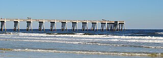
St. Augustine Beach is a city in St. Johns County, Florida, United States. The population was 6,803 at the 2020 US census.

<span class="mw-page-title-main">Florida State Road A1A</span> State highway in Florida, United States

State Road A1A (SR A1A) is a major north–south Florida State Road consisting of seven separate sections running a total of 338.752 miles (545.168 km) along the Atlantic Ocean, from Key West at the southern tip of Florida, to Fernandina Beach, just south of Georgia on Amelia Island. It is the main road through most oceanfront towns. Part of SR A1A is designated the A1A Scenic and Historic Coastal Byway, a National Scenic Byway. A portion of SR A1A that passes through Volusia County is designated the Ormond Scenic Loop and Trail, a Florida Scenic Highway. It is also called the Indian River Lagoon Scenic Highway from State Road 510 at Wabasso Beach to U.S. Route 1 in Cocoa. SR A1A is famous worldwide as a center of beach culture in the United States, a scenic coastal route through most Atlantic coastal cities and beach towns, including the unique tropical coral islands of the Florida Keys. SR A1A also serves as a major thoroughfare through Miami Beach and other south Florida coastal cities.

<span class="mw-page-title-main">Florida State Road 200</span> State highway in Florida, United States

State Road 200 is a major diagonal road in central and northeast Florida. Its southern terminus is at US 41 in Hernando. Its eastern terminus is at SR A1A in Fernandina Beach, at the corner of Atlantic Avenue and Fletcher Avenue.

<span class="mw-page-title-main">Jacksonville metropolitan area</span> Metropolitan Statistical Area in the United States

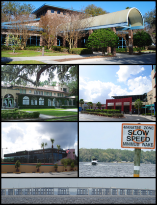
The Jacksonville Metropolitan Area, also called the First Coast, Metro Jacksonville, or Northeast Florida, is the metropolitan area centered on the principal city of Jacksonville, Florida and including the First Coast of North Florida. As of the 2020 United States census, the total population was 1,605,848. The Jacksonville–Kingsland–Palatka, FL–GA Combined Statistical Area (CSA) had a population of 1,733,937 in 2020 and was the 34th largest CSA in the United States. The Jacksonville metropolitan area is the 40th largest in the country and the fourth largest in the State of Florida, behind the Miami, Tampa, and Orlando metropolitan areas.

<span class="mw-page-title-main">U.S. Route 1 in Florida</span> Highway in Florida

U.S. Highway 1 (US 1) in Florida runs 545 miles (877 km) along the state's east coast from Key West to its crossing of the St. Marys River into Georgia north of Boulogne and south of Folkston. US 1 was designated through Florida when the U.S. Numbered Highway System was established in 1926. With the exception of Monroe County, the highway runs through the easternmost tier of counties in the state, connecting numerous towns and cities along its route, including nine county seats. The road is maintained by the Florida Department of Transportation (FDOT).

References

  1. "FLORIDA CITIES BY INCORPORATION YEAR" (PDF). Florida League of Cities.
  2. "2020 U.S. Gazetteer Files". United States Census Bureau. Retrieved October 31, 2021.
  3. 1 2 "U.S. Census website". United States Census Bureau . Retrieved 2008-01-31.
  4. "US Board on Geographic Names". United States Geological Survey. 2007-10-25. Retrieved 2008-01-31.
  5. "Census of Population and Housing". Census.gov. Retrieved June 4, 2015.
  6. "P2 HISPANIC OR LATINO, AND NOT HISPANIC OR LATINO BY RACE - 2010: DEC Redistricting Data (PL 94-171) - Callahan town, Florida". United States Census Bureau .
  7. "P2 HISPANIC OR LATINO, AND NOT HISPANIC OR LATINO BY RACE - 2020: DEC Redistricting Data (PL 94-171) - Callahan town, Florida". United States Census Bureau .
  8. "S1101 HOUSEHOLDS AND FAMILIES - 2020: Callahan town, Florida". United States Census Bureau .
  9. "S1101 HOUSEHOLDS AND FAMILIES - 2010: Callahan town, Florida". United States Census Bureau .
  10. "Callahan Branch Library." Nassau County Public Library. Retrieved on February 10, 2017. "Callahan Library Branch 450077 State Rd. 200 Suite 15 Callahan, FL 32011"
  11. "Station 50." Nassau County. Retrieved on February 14, 2017. "Station 50 Callahan 542310 US Hwy 1 Callahan, Florida 32011"