Kingsville | |
---|---|
Town of Kingsville | |
Nickname: Canada's Southernmost Town | |
Coordinates: 42°6′N82°43′W / 42.100°N 82.717°W | |
Country | Canada |
Province | Ontario |
County | Essex |
Incorporated | 1901 |
Government | |
• Mayor | Dennis Rogers |
• MP | Chris Lewis (CPC) |
• MPP | Anthony Leardi (PC) |
Area | |
• Land | 246.83 km2 (95.30 sq mi) |
Elevation | 200.00 m (656.17 ft) |
Population (2016) [1] | |
• Total | 21,552 |
• Density | 87.3/km2 (226/sq mi) |
Time zone | UTC-5 (Eastern (EST)) |
• Summer (DST) | UTC-4 (EDT) |
Forward sortation area | |
Area code(s) | 519 and 226 |
Website | www.kingsville.ca |
Kingsville is a town in Essex County in southwestern Ontario, Canada. It is Canada's southernmost municipality with town status. The town had a population of 21,552 in the Canada 2016 Census, [1] up from 21,362 in the Canada 2011 Census. [3]
Kingsville was incorporated as a town in 1901. On 1 January 1999, the Town was amalgamated with the adjoining Township of Gosfield North and Township of Gosfield South to form an expanded municipality. [4]
Kingsville is west of the Municipality of Leamington, south of the Town of Lakeshore and southeast of the Town of Essex and north of Lake Erie.
The geography of Kingsville is typical of most of Essex County. The terrain is generally flat, and consists of glacial drift which is a mixture of various rocks, sand and clay. The town is approximately 570 feet above sea level.
In addition to the primary settlement at Kingsville, the municipality also includes the smaller communities of Cedar Beach, Cedar Island, Cedarhurst Park, Cottam, Klondyke, Linden Beach, North Ridge, Olinda, Ruthven and Union. The community of Albuna is located on the boundary between Kingsville and Leamington, and the communities of Arner and Elford are located on the boundary between Kingsville and Essex.
Climate data for Kingsville (1981−2010) | |||||||||||||
---|---|---|---|---|---|---|---|---|---|---|---|---|---|
Month | Jan | Feb | Mar | Apr | May | Jun | Jul | Aug | Sep | Oct | Nov | Dec | Year |
Record high °C (°F) | 15.0 (59.0) | 16.0 (60.8) | 24.5 (76.1) | 27.0 (80.6) | 31.0 (87.8) | 37.5 (99.5) | 36.5 (97.7) | 36.0 (96.8) | 34.5 (94.1) | 26.5 (79.7) | 20.0 (68.0) | 16.0 (60.8) | 37.5 (99.5) |
Average high °C (°F) | −0.3 (31.5) | 1.0 (33.8) | 5.7 (42.3) | 12.4 (54.3) | 19.0 (66.2) | 24.3 (75.7) | 26.8 (80.2) | 25.8 (78.4) | 21.8 (71.2) | 15.1 (59.2) | 8.3 (46.9) | 2.3 (36.1) | 13.5 (56.3) |
Daily mean °C (°F) | −3.7 (25.3) | −2.5 (27.5) | 1.7 (35.1) | 7.9 (46.2) | 14.4 (57.9) | 19.9 (67.8) | 22.5 (72.5) | 21.6 (70.9) | 17.7 (63.9) | 11.1 (52.0) | 5.0 (41.0) | −0.6 (30.9) | 9.6 (49.3) |
Average low °C (°F) | −7.1 (19.2) | −6.1 (21.0) | −2.3 (27.9) | 3.4 (38.1) | 9.8 (49.6) | 15.6 (60.1) | 18.3 (64.9) | 17.3 (63.1) | 13.5 (56.3) | 7.1 (44.8) | 1.8 (35.2) | −3.6 (25.5) | 5.6 (42.1) |
Record low °C (°F) | −29.0 (−20.2) | −26.0 (−14.8) | −22.0 (−7.6) | −13.0 (8.6) | −2.0 (28.4) | 3.9 (39.0) | 6.0 (42.8) | 6.0 (42.8) | −0.6 (30.9) | −5.0 (23.0) | −11.5 (11.3) | −23.0 (−9.4) | −29.0 (−20.2) |
Average precipitation mm (inches) | 61.2 (2.41) | 59.0 (2.32) | 65.0 (2.56) | 86.7 (3.41) | 84.2 (3.31) | 73.3 (2.89) | 84.1 (3.31) | 81.1 (3.19) | 87.9 (3.46) | 71.9 (2.83) | 79.0 (3.11) | 67.3 (2.65) | 900.5 (35.45) |
Average rainfall mm (inches) | 32.9 (1.30) | 36.8 (1.45) | 49.7 (1.96) | 84.3 (3.32) | 84.2 (3.31) | 73.3 (2.89) | 84.1 (3.31) | 81.1 (3.19) | 87.9 (3.46) | 71.9 (2.83) | 76.4 (3.01) | 51.9 (2.04) | 814.2 (32.06) |
Average snowfall cm (inches) | 28.3 (11.1) | 22.2 (8.7) | 15.3 (6.0) | 2.4 (0.9) | 0.0 (0.0) | 0.0 (0.0) | 0.0 (0.0) | 0.0 (0.0) | 0.0 (0.0) | 0.0 (0.0) | 2.5 (1.0) | 15.5 (6.1) | 86.3 (34.0) |
Average precipitation days (≥ 0.2 mm) | 10.7 | 9.5 | 11.4 | 13.0 | 12.3 | 10.0 | 9.3 | 8.9 | 9.7 | 10.7 | 11.9 | 12.0 | 129.3 |
Average rainy days (≥ 0.2 mm) | 4.6 | 5.3 | 8.5 | 12.4 | 12.3 | 10.0 | 9.3 | 8.9 | 9.7 | 10.7 | 11.3 | 8.2 | 111.1 |
Average snowy days (≥ 0.2 cm) | 6.5 | 4.7 | 3.8 | 0.73 | 0.0 | 0.0 | 0.0 | 0.0 | 0.0 | 0.08 | 0.96 | 4.6 | 21.4 |
Source: Environment Canada [2] |
Year | Pop. | ±% |
---|---|---|
1871 | 800 | — |
1901 | 1,537 | +92.1% |
1911 | 1,427 | −7.2% |
1921 | 1,783 | +24.9% |
1931 | 2,174 | +21.9% |
1941 | 2,317 | +6.6% |
1951 | 2,631 | +13.6% |
1961 | 3,041 | +15.6% |
1971 | 4,076 | +34.0% |
1981 | 5,134 | +26.0% |
1991 | 5,716 | +11.3% |
2001 | 19,619 | +243.2% |
2006 | 20,908 | +6.6% |
2011 | 21,362 | +2.2% |
2016 | 21,552 | +0.9% |
[5] [3] [1] |
In the 2021 Census of Population conducted by Statistics Canada, Kingsville had a population of 22,119 living in 8,285 of its 8,635 total private dwellings, a change of 2.6% from its 2016 population of 21,552. With a land area of 246.08 km2 (95.01 sq mi), it had a population density of 89.9/km2 (232.8/sq mi) in 2021. [6]
2021 | 2016 | 2011 | |
---|---|---|---|
Population | 22,119 (+2.6% from 2016) | 21,552 (0.9% from 2011) | 21,362 (2.2% from 2006) |
Land area | 246.08 km2 (95.01 sq mi) | 246.83 km2 (95.30 sq mi) | 246.84 km2 (95.31 sq mi) |
Population density | 89.9/km2 (233/sq mi) | 87.3/km2 (226/sq mi) | 86.5/km2 (224/sq mi) |
Median age | 45.2 (M: 42.8, F: 47.2) | 42.0 (M: 40.8, F: 43.4) | |
Private dwellings | 8,635 (total) 8,285 (occupied) | 8359 (total) | 8170 (total) |
Median household income | $94,000 |
Canada 2006 Census | Population | % of Total Population | |
---|---|---|---|
Visible minority group Source: [10] | South Asian | 0 | 0% |
Chinese | 30 | 0.1% | |
Black | 190 | 0.9% | |
Filipino | 20 | 0.1% | |
Latin American | 395 | 1.9% | |
Arab | 80 | 0.4% | |
Southeast Asian | 15 | 0.1% | |
West Asian | 0 | 0% | |
Korean | 0 | 0% | |
Japanese | 0 | 0% | |
Other visible minority | 0 | 0% | |
Mixed visible minority | 10 | 0% | |
Total visible minority population | 740 | 3.6% | |
Aboriginal group Source: [11] | First Nations | 105 | 0.5% |
Métis | 75 | 0.4% | |
Inuit | 0 | 0% | |
Total Aboriginal population | 180 | 0.9% | |
White | 19,580 | 95.5% | |
Total population | 20,500 | 100% |
Kingsville is home to the Jack Miner Bird Sanctuary. Jack Miner was awarded The Order of the British Empire (OBE) for his achievements in conservation in the British Empire. It was awarded June 23, 1943, by King George VI, as King of Canada. Jack Miner is considered "the father of the conservation movement on the continent". [12]
Kingsville is home to Colasanti's Tropical Gardens which attracts people from all over Ontario. The gardens have many varieties of tropical plants and animals. Kingsville is also home to the Kingsville Folk Festival which is directed by Michelle Law. It began in early August 2014 and hopes to continue each year with headliners such as Bruce Cockburn.
Kingsville was, for 26 years, the home town of the Great Lakes Jr. C team Kingsville Comets. The team was sold and moved to Amherstburg in 2013, becoming the Amherstburg Admirals. The town was among the top 5 places in Canada chosen for CBC's Kraft Hockeyville 2008, and finished in 2nd place in the competition with over 1.5 million votes.
In 2015, the Kingsville Kings were formed and added to the South Conference of the Greater Metro Junior A Hockey League. [13] They play out of the Kingsville Arena Complex.
After playing a neutral site game in Kingsville during the 2016–17 season, the St. Clair Shores Fighting Saints of the Federal Hockey League relocated to Kingsville for the 2017–18 season as the North Shore Knights. [14] The team played most of its home games out of the Kingsville Arena Complex with a few other neutral site home games in various cities in Ontario and Quebec. After cancelling several games during the season, the Knights were not listed as an FHL member the following season.
Team Canada women's ice hockey player Meghan Agosta is from the Ruthven community in Kingsville. Agosta scored a hat trick on her birthday during the 2006 Winter Olympic games in Turin Italy.
Former major league baseball pitcher, Paul Quantrill, although born in London, Ontario, grew up in Kingsville.
Kingsville has three elementary schools, Kingsville Public School, Jack Miner Public School and St. John de Brebeuf Catholic Elementary School.
A fourth school, Ruthven Public School, was closed in the summer of 2013 due to overall declining enrollment. Students from Ruthven were assigned to Jack Miner Public School.
Kingsville District High School has a student population of 656. [15]
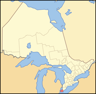
Essex County is a primarily rural county in Southwestern Ontario, Canada comprising seven municipalities: Amherstburg, Kingsville, Lakeshore, LaSalle, Leamington, Tecumseh and the administrative seat, Essex.
Leamington is a municipality in Essex County, Ontario, Canada. With a population of 29,680 in the Canada 2021 Census, it forms the second largest urban centre in Windsor-Essex County after Windsor, Ontario. It includes Point Pelee National Park, the southernmost point of mainland Canada.
Chatham-Kent is a single-tier municipality in Southwestern Ontario, Canada. It is mostly rural, and its population centres are Chatham, Wallaceburg, Tilbury, Blenheim, Ridgetown, Wheatley and Dresden. The current Municipality of Chatham-Kent was created in 1998 by the amalgamation of Blenheim, Bothwell, Camden, the City of Chatham, the Township of Chatham, Dover, Dresden, Erie Beach, Erieau, Harwich, Highgate, Howard, Orford, Raleigh, Ridgetown, Duart, Thamesville, Tilbury East, Tilbury, Wallaceburg, Wheatley and Zone.
Amherstburg is a town near the mouth of the Detroit River in Essex County, Ontario, Canada. In 1796, Fort Malden was established here, stimulating growth in the settlement. The fort has been designated as a National Historic Site.
Tecumseh is a town in Essex County in Southwestern Ontario, Canada. It is on Lake St. Clair east of Windsor and had a population of 23,229 at the 2016 census. It is part of the Windsor census metropolitan area, and is a part of the Windsor-Essex County region along with Amherstburg, Kingsville, Lakeshore, LaSalle and Leamington. Tecumseh was originally a Franco-Ontarian settlement.
Lakeshore is a municipality on Lake St. Clair, in Essex County, Ontario, Canada. It was incorporated in 1999 by amalgamating the Town of Belle River with the townships of Maidstone, Rochester, Tilbury North, and Tilbury West. It is the largest and the most populous municipality within Essex County. However, it is part of the Windsor census metropolitan area.
Essex is a town with a population of 21,216 in Essex County in southwestern Ontario, Canada, whose municipal borders extend to Lake Erie. Essex is also the name of the largest community within the municipality.
Essex is a federal electoral district in Ontario, Canada, represented in the House of Commons of Canada from 1867 to 1882 and since 1968.
For the defunct provincial electoral district, see Essex South.
Essex—Kent was a federal electoral district in Ontario that was represented in the House of Commons of Canada from 1979 to 1997.
The Greater Essex County District School Board was created on January 1, 1998, with the amalgamation of the Windsor Board of Education and the Essex County Board of Education. The school board services families in both Windsor, Ontario and Essex County, Ontario in Canada.
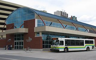
Transit Windsor provides public transportation in the city of Windsor, Ontario, Canada as well as LaSalle, Essex, Kingsville, Amherstburg and Leamington and serves more than 6 million passengers each year, covering an area of 310 km2 (120 sq mi) and a population of 235,000. They operate a cross border service between the downtown areas of Windsor and Detroit, Michigan via the Tunnel Bus, and service to events at Detroit's Comerica Park, Little Caesars Arena, Huntington Place, and Ford Field. The Windsor International Transit Terminal neighbours with the Windsor International Aquatic and Training Centre.
Lambton Shores is a municipality in Lambton County, Ontario, Canada, that is on the southern shores of Lake Huron.
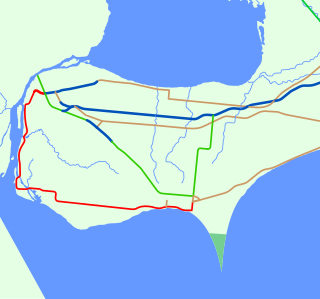
The Chrysler Canada Greenway is a 42 km-long rail trail in Essex County, Ontario, Canada, stretching from Oldcastle to Leamington.
The Essex Region Conservation Authority (ERCA) is a public-sector agency with delegated provincial authority to address risks of natural hazards, relating to flooding and erosion.
King's Highway 107, commonly referred to as Highway 107, was a provincially maintained highway in the Canadian province of Ontario situated midway between the towns of Kingsville and Leamington. The route was one of the shortest highways to exist in the province, at a length of 1.5 kilometres (0.93 mi). It has been through several re-numberings throughout its history but is now known as Essex County Road 45 or Union Avenue. The route began at Highway 18 and travelled north to Highway 3 at Ruthven.
King's Highway 18, commonly referred to as Highway 18, was a provincially maintained highway in the Canadian province of Ontario, located entirely within Essex County. Since 1998, the majority of the former route has been known as Essex County Road 20. The route travelled at the southernmost point in Canada, along or near the shoreline of the Detroit River and Lake Erie between Windsor and Leamington, with Highway 3 as the terminus at both ends. The former route provides access to the communities of LaSalle, Amherstburg, Malden Centre, Harrow, Kingsville and Union.
Leamington Transit is the current mode of public transportation in Leamington, Ontario Canada. It consists of a micro coach that services the town of Leamington making regular routes Monday to Saturday, 7:00 am – 7:00 pm.
The Amherstburg Admirals are a Canadian junior ice hockey club based in Amherstburg, Ontario, Canada. They are members of the Provincial Junior Hockey League of the Ontario Hockey Association.
The Kingsville Reporter was a weekly newspaper published in Kingsville, Ontario, Canada. Owned by Postmedia Network, it published papers every Tuesday.