Kinloch Hourn

Last updated
Farmhouse in Kinloch Hourn Kinloch Hourn - geograph.org.uk - 18409.jpg
Farmhouse in Kinloch Hourn

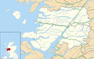
Kinloch Hourn is a small settlement at the end of Loch Hourn, in the West Highlands of Scotland. The name comes from the Gaelic, Ceann Loch Shubhairne, for "the head of Loch Hourn". Kinloch Hourn is at the end of 35 km (22 miles) of single-track road, which runs west from a junction with the A87 beside Loch Garry. [1]

Loch Hourn

Loch Hourn is a sea loch which separates the peninsulae of Kintail to the north and Knoydart to the south, on the west coast of Scotland.

Scottish Highlands Place

The Highlands is a historic region of Scotland. Culturally, the Highlands and the Lowlands diverged from the later Middle Ages into the modern period, when Lowland Scots replaced Scottish Gaelic throughout most of the Lowlands. The term is also used for the area north and west of the Highland Boundary Fault, although the exact boundaries are not clearly defined, particularly to the east. The Great Glen divides the Grampian Mountains to the southeast from the Northwest Highlands. The Scottish Gaelic name of A' Ghàidhealtachd literally means "the place of the Gaels" and traditionally, from a Gaelic-speaking point of view, includes both the Western Isles and the Highlands.

Scotland Country in Europe, part of the United Kingdom

Scotland is a country that is part of the United Kingdom. Sharing a border with England to the southeast, Scotland is otherwise surrounded by the Atlantic Ocean to the north and west, by the North Sea to the northeast and by the Irish Sea to the south. In addition to the mainland, situated on the northern third of the island of Great Britain, Scotland has over 790 islands, including the Northern Isles and the Hebrides.

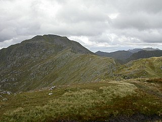
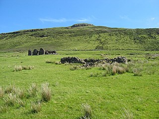
From Kinloch Hourn, a path continues along the south side of the loch to Barrisdale. The path then climbs over Màm Barrisdale, before dropping down to the village of Inverie in Knoydart. This route once had a number of townships along it, and may have been used as a coffin road. [2] This is also used as a walking route into the mountains of Knoydart, including Ladhar Bheinn and Luinne Bheinn. [3]

Inverie human settlement in the United Kingdom

Inverie is the main village on the peninsula of Knoydart in the Scottish Highlands and is concentrated on the north side of Loch Nevis. Although on the mainland of Britain, the few miles of single-track road are not connected to the rest of the national road network. Inverie is only reachable, aside from a 17-mile (27 km) hike over very rough terrain, by a regular 7-mile (11 km) ferry from Mallaig, giving the place a Guinness National Record for remoteness.

Knoydart

Knoydart is a peninsula in Lochaber, Highland, on the west coast of Scotland. Knoydart is sandwiched between Lochs Nevis and Hourn — often translated as "Loch Heaven" and "Loch Hell" respectively, although the somewhat poetic nature of these derivations are disputed. Forming the northern part of what is traditionally known as na Garbh-Chrìochan or "the Rough Bounds", because of its harsh terrain and remoteness, Knoydart is also referred to as "Britain's last wilderness". It is only accessible by boat, or by a 16-mile (26 km) walk through rough country, and the seven miles (11 km) of tarred road are not connected to the UK road system.

Corpse road

Corpse roads provided a practical means for transporting corpses, often from remote communities, to cemeteries that had burial rights, such as parish churches and chapels of ease. In Britain, such routes can also be known by a number of other names, e.g.: bier road, burial road, coffin line, coffin road, corpse way, funeral road, lych way, lyke way, or procession way. etc. Such "church-ways" have developed a great deal of associated folklore regarding ghosts, spirits, wraiths, etc.

To the north of Loch Hourn is the route of an old drove road, which ran between Kinloch Hourn to Glenelg. Cattle from Skye were driven across Kyle Rhea to Glenelg, along this route to Kinloch Hourn, then onwards down Glen Garry. [4]

Glenelg, Highland human settlement

Glenelg is a scattered community area and civil parish in the Lochalsh area of Highland in western Scotland. Despite the local government reorganisation the area is considered by many still to be in Inverness-shire, the boundary with Ross-shire being at the top of Mam Ratagan the single track road entry into Glenelg.

Related Research Articles

West Highland Way walking path

The West Highland Way is a linear long distance footpath in Scotland. It is 154 km long, running from Milngavie north of Glasgow to Fort William in the Scottish Highlands, with an element of hill walking in the route. The trail, which opened in 1980, was Scotland's first officially designated Long Distance Route, and is now designated by Scottish Natural Heritage as one of Scotland's Great Trails. It is primarily intended as a long distance walking route, and whilst many sections are suitable for mountain biking and horseriding there are obstacles and surfaces that will require these users to dismount in places.

Loch Rannoch loch

Loch Rannoch is a freshwater loch in Perth and Kinross, Scotland. It is over 15 kilometres (9.3 mi) long in a west–east direction with an average width of about 1.2 kilometres (0.75 mi), and is deepest at its eastern end, reaching a depth of 130 metres (440 ft). The River Tummel begins at its eastern end, where the small village of Kinloch Rannoch can be found, whilst the wild expanse of Rannoch Moor extends to the west of the loch. The area surrounding Loch Rannoch, along with Rannoch Moor itself, was formerly part of the native Caledonian Forest that stretched across much of Northern Scotland. Native forest is now largely absent from much of area, due partly to logging, and partly to the climate becoming wetter, and Loch Rannoch is now largely surrounded by commercial forestry and open hillsides, although a small area remains at the Black Wood of Rannoch on the southern shore of the loch.

Blà Bheinn mountain in the United Kingdom

Blà Bheinn, is a mountain on the Isle of Skye in Scotland. It is usually regarded as an outlier to the Black Cuillin. It is mainly composed of gabbro, a rock with excellent grip for mountaineers and scramblers. The name Blà Bheinn is thought to mean "blue mountain", from a combination of Norse and Gaelic. Whereas blå in Modern Norwegian means "blue", the Old Norse word blá could, however, also refer to the colours blue-black and black.

Sgùrr na Cìche mountain in the United Kingdom

Sgùrr na Cìche is a mountain in the Knoydart region, in the west of Scotland. It lies on the edge of Knoydart in an area known as the Rough Bounds of Knoydart.

Ladhar Bheinn mountain in the United Kingdom

Ladhar Bheinn is the highest mountain in the Knoydart region of the Highlands of Scotland. It is the most westerly Munro on the Scottish mainland.

Tomdoun is a settlement on the north side of the River Garry, near the western end of Loch Garry, in Glen Garry in the Highlands of Scotland. The name comes from the Gaelic for "the brown hillock".

Arnisdale human settlement in United Kingdom

Arnisdale is a hamlet in the historic county of Inverness-shire in the local authority area of Highlands of Scotland. It lies on the north shore of Loch Hourn, around 10 miles down a single track road from Glenelg. It has a permanent population of around 30 and several holiday cottages. At the end of the village is a large white-painted hunting lodge called Arnisdale House, built in 1898.

Beinn Sgritheall mountain in the United Kingdom

Beinn Sgritheall is the highest mountain in the Glenelg area of the Highlands of Scotland. The main approach is via Arnisdale on the shores of Loch Hourn or via Gleann Beag to the north, with its well-known brochs. The view from the summit was described by Sir Hugh Munro, a founder member of the Scottish Mountaineering Club, as "perhaps the most beautiful I have seen in Scotland".

Sgùrr a Mhaoraich mountain in United Kingdom

Sgùrr a' Mhaoraich is a Scottish mountain located to the north of Loch Quoich in the north western highlands. It has a height of 1027 m (3369 ft) and is classed as a Munro. Viewed from Kinloch Hourn to the west, or from the north, it shows large, steep, rocky flanks with a complex series of ridges and corries, but like its neighbours such as Gleouraich, its southern side is gentler and grassier.

Ben Mor Coigach mountain in the United Kingdom

Ben Mor Coigach is a long, table shaped mountain in the far north-west of Scotland. It dominates the Coigach peninsula, in the county of Ross and Cromarty, 10 kilometres north-west of the town of Ullapool. It reaches a height of 743 metres (2438 feet). Its coastal location, combined with its high topographic prominence to height ratio, make it a very good viewpoint.

Sgùrr nan Eugallt is the highest of a well defined group of mountains that lie south of Loch Hourn, stretching from Barrisdale to Loch Quoich. Although its summit is lower than many nearby neighbours, it is cut off from all its higher neighbours by a ring of deep glens. Despite being in a very wild and remote area, it can be easily ascended from a ruined roadside cottage 4 km to the east of its summit, where there is limited parking space. But the road is single track and the cottage is 20 miles from the nearest main road. Due to its isolation and insufficient height to qualify for Munro's Tables, Sgùrr nan Eugallt is infrequently climbed.

Rob Roy Way

The Rob Roy Way is a Scottish long distance footpath that runs from Drymen in Stirling to Pitlochry in Perth and Kinross. The path was created in 2002, and takes its name from Rob Roy MacGregor, a Scottish folk hero and outlaw of the early 18th century. It traverses countryside that he knew and travelled frequently. The route crosses the Highland Boundary Fault, a geological fault where the Highlands meet the Lowlands. Views from the trail overlook Loch Lubnaig, Loch Earn, Loch Venachar and Loch Tay. The way is 127 kilometres (79 mi) in length if the direct route along the southern shore of Loch Tay and the River Tay is followed between Ardtalnaig and Aberfeldy. A optional loop also link these places via Amulree: choosing this option increases the length by a further 27 kilometres (17 mi) to 154 kilometres (96 mi).

The Sound of Sleat is a narrow sea channel off the western coast of Scotland. It divides the Sleat peninsula on the south-east side of the Isle of Skye from Morar, Knoydart and Glenelg on the Scottish mainland.

Borders Abbeys Way

The Borders Abbeys Way is a long-distance footpath in the Scottish Borders area of Scotland. It is a circular walkway and is 109 kilometres (68 mi) in length. The theme of the footpath is the ruined Borders abbeys along its way: Kelso Abbey, Jedburgh Abbey, Melrose Abbey and Dryburgh Abbey. These abbeys were homes to monks, who lived there between the 12th and 16th centuries. The route also passes through the towns of Hawick and Selkirk, and close to Abbotsford House, the home of Sir Walter Scott. Along the Borders Abbeys Way there are several rivers: Jed Water, River Teviot, River Tweed, Ale Water, and Rule Water.

Beinn na Caillich (Knoydart)

Beinn na Caillich is a mountain in Knoydart, in the West Highlands of Scotland. It is on the southern shore of Loch Hourn, to the north-west of the Munro of Ladhar Bheinn.

Mugeary mountain in United Kingdom

Mugeary is a farm or croft and former settlement on the island of Skye, Scotland. Located 4 km (2.5 mi) south west of Portree is known as the location where the basaltic rock mugearite was first identified. The Gaelic name is derived from Old Norse and probably means "narrow field".

References

  1. "Kinloch Hourn Feature Page". Undiscovered Scotland. Retrieved 23 May 2011.
  2. "Old Road to Kinloch Hourn". Heritage Paths. ScotWays. Retrieved 23 May 2011.
  3. "Ladhar Bheinn". Walking Scotland. VisitScotland. Retrieved 26 May 2011.
  4. "Kinloch Hourn Drove Road". Heritage Paths. ScotWays. Retrieved 26 May 2011.

Coordinates: 57°06′22″N5°23′13″W / 57.106°N 5.387°W / 57.106; -5.387

Geographic coordinate system Coordinate system

A geographic coordinate system is a coordinate system that enables every location on Earth to be specified by a set of numbers, letters or symbols. The coordinates are often chosen such that one of the numbers represents a vertical position and two or three of the numbers represent a horizontal position; alternatively, a geographic position may be expressed in a combined three-dimensional Cartesian vector. A common choice of coordinates is latitude, longitude and elevation. To specify a location on a plane requires a map projection.