The village has three schools: Foley Infant Academy, Brindley Heath Academy and Kinver High School, now part of the Invictus Multi Academy Trust. During normal times, the Infant school rings the home time bell 20 minutes before the junior or high schools. This is to allow the parents collecting children from both sites to cover the three-quarters of a mile journey.
During lockdown and as the return to school is phased-in, times are staggered and year groups arrive and leave at different times to reduce the number of people at the gates at any one time.
The village has a number of events throughout the year, including open gardens, beer festivals at various venues and concerts at the Community Centre and St. Peter's Church.
The parish
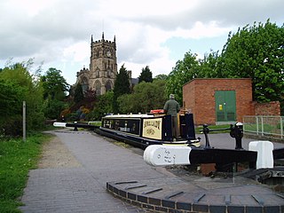
St. Peters Church, Kinver
St. Peter's Church, the village and parish church sits in a prominent position on a hill just south of the village.
Several hamlets lie in the parish of Kinver, including Dunsley, Compton, Stourton and Whittington. The neighbouring village of Enville is in its own parish.
Transport
Kinver operates the 242 service from Kinver to Stourbridge and 580 TUES/THU/FRI Twice a day to Kidderminster
Route
Destination
Operator
Notes
02420
Stourbridge
Select Bus Services
Monday to Saturday; plus school service 242S on schooldays
Kinver has, at various times in the past, been spelt on maps and documents as: Kinfare, Kynfare, Chenfare, Chenevare, Chenefare (as listed in the Domesday Book) and Cynefare. The earliest form of the name is Cynibre, in a charter of 736 AD. The first element may be assimilated to cyne 'royal', but may come from a Celtic root cuno- 'dog'. The second element -bre refers to a steep hill,[2] probably Kinver Edge. The ancient Hill Fort atop the Edge is of possible Bronze-age and certainly Iron Age origin. A Roman presence at nearby Greensforge Fort dates from around 47 AD.
The hilltop church is on a very ancient site, and the current church, dedicated to St. Peter dates from the 12th century. The village High Street was laid out as the burgages of a new town by the lord of the manor in the late 13th century and was administered by a borough court, separate for the manorial court for the rest of the manor of Kinver and Stourton (known as Kinfare Foreign).
The main pub, The White Hart, dates from the 14th century, and the Anchor Hotel (now developed as housing) from the 15th century. The grammar school opened in 1511, the first teacher being a priest paid by local men, and functioned as a school until closure in 1916. School accounts from the 1700s are held at the University of Birmingham.[3]
Kinver was known for making sturdy woollen cloth, using the flow of the Stour for fulling mills and dyeing. The village also profited from being a stop on the great "Irish Road" from Bristol to Chester (until the 19th century, the port of embarkation for Ireland), the 'White Hart' being the oldest and largest inn.
There was a brief cavalry melee on the Heath during the English Civil War between "Tinker Fox" the local Parliamentary commander and local Royalist forces. Fox retired to Stourton Castle which was briefly invested by the Royalists. During his flight from the Battle of WorcesterKing Charles II made his way over Whittington Heath into nearby Stourbridge.
Later, the river was used to power finery forges and from 1628 slitting mills, including Hyde Mill which has been claimed (incorrectly) as the earliest in England, though it certainly was among the earliest. There were five slitting mills in the parish by the late 18th century, more than any other parish in Great Britain. These slit bars of iron into rods to be made into nails in the nearby Black Country.[4]
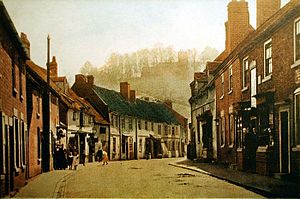
Kinver High Street, and St Peter's on Church Hill behind. Circa 1910.
Stourton Castle figured notably in the history of the English Civil Wars. It was the birthplace of cardinal Reginald Pole, last catholic archbishop of Canterbury, who came within a whisker of the papacy.
In 1771 the area was opened up to trade by the Staffordshire and Worcestershire Canal, built by James Brindley.
In Victorian and Edwardian times Kinver was a popular Sunday day out for people from Birmingham and the Black Country, via a 1901 pole & wires tram extension that ran across the fields, the "Kinver Light Railway".
The nailshops and forges ceased work around 1892, and local ironworks are thought to have all closed in about 1912 or 1913.
Myths
According to local eyewitness accounts,[citation needed] a panther may roam the woods and fields of Kinver. It is believed this so-called 'Beast of Kinver' was once kept as a pet but was released into the wild when new laws restricting the keeping of wild animals were introduced in the 1960s. A former policeman who saw the creature described it as resembling a European Lynx.
The larger Witch's Tree at the base of the Edge is also renowned for various visions and sightings. This was believed to be the central location for the witch trials in the area and several women were believed to be hanged for witchcraft and heresy.
Other myths and legends include the sightings of many ghosts and spirits, especially around the area of the Scout camp which is situated between the Edge and St Peter's Church. Ghosts here include the mysterious Lottie who was kidnapped from the nearby village in the mid-1850s but escaped her captors only to be chased over the Edge before her footprints mysteriously disappeared from the snowy track.[citation needed]
Other famous hauntings include the spirit of Lady Jane Grey, (who, for nine days, was intruded as Queen of England immediately prior to Queen Mary Tudor) whose ghost has been reported at the Whittington Inn, and the infamous William Howe, a footpad who murdered Benjamin Robins of Dunsley Hall and became the penultimate person to be gibbeted at nearby Gibbet Lane in the early 19th century.
A famous story goes that Richard Foley (known as "Fiddler Foley") had carried out industrial espionage in Sweden by posing as a wandering musician. By this stratagem he was said to have gained the knowledge necessary to instal his slitting mill at Hyde. The former iron foundry there was one of the places where Dud Dudley attempted his revolutionary innovations, and it has been shown that he was an ancestor of Abraham Darby who later perfected the smelting of iron with coal (research by Carl Higgs).
There is a long-standing tradition that Wulfhere King of Mercia (succeeded 657) dedicated the parish church of St Peter in memory of his sons, Wulphad and Ruffius, who he had killed in anger when they converted to Christianity (Seisdon Council Guide, 1966).
These claims are in fact unfounded: Dick Whittington (q.v.) came from Gloucestershire. The Whittington Inn was merely a farmhouse belonging to a freeholder of the manor of Whittington. The 18th century manor house was undoubtedly Whittington Hall (now Whittington Hall Farm). This belonged to the lords of the manor, and probably had done so since the mediaeval period.[5]
Kinver Light Railway
Kinver Light Railway, an innovative electric light tramway opened on 4 April 1901 and helped establish the local tourism industry. However, as buses became more popular during the 1920s, it was eventually closed on 8 February 1930.
Transport today is provided by Select Bus service 242 from Stourbridge to Kinver which departs Stourbridge at xx40 Mon-Sat daytime. (There are no journeys at 1540 from Stourbridge or at 1510 and 1610 from Kinver due to the bus being used on a school route.) Diamond Bus 580 operates one journey each way to Kidderminster on Tuesday, Thursday and Friday only. The 580 service number dates back to when Kinver was connected to Wolverhampton as part of the South Staffordshire bus routes at one time numbered 580-589 and which served a number of rural communities in South Staffordshire. These connections were withdrawn in 2017 as part of cuts in funding a number of bus services in the county of Staffordshire. Service 242 was previously operated by The Green Bus Company but due to a shortage of drivers, was awarded to Select Bus in September 2021 as an emergency replacement.
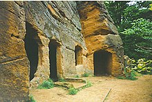
Such rock houses were the setting of a book and silent film, Bladys of the Stewponey (1919, Sabine Baring-Gould), but most of this has since been lost. The "Stewponey" refers to an ancient inn (now demolished and replaced by flats) at Stourton in Kinver parish.
Tony Marsh (1931–2009) a British racing driver and six-times RAC Hill climb champion lived in the village
Alan Duff (1938 in Kinver – 1989) an English first-class cricketer who played 1950s-1960s
Nick Owen (born 1947) an English TV presenter and newsreader, presents BBC Midlands Today; Chairman of Luton Town Football Club 2008–2017, believed to live in the village
Robert Plant CBE (born 1948) an English singer, songwriter, and musician, the lead singer and lyricist of the rock band Led Zeppelin, lives in Shatterford, a regular visitor to the village
Louis Barnett (born 1991 in Kinver) a licensed chocolatier who became the youngest supplier of both the Sainsbury's and Waitrose supermarket chains at the age of 14
Just outside Kinver are Drakelow Tunnels. The tunnels were used for various purposes by the MoD for many years.
The tunnels were originally built as a Second World Warshadow factory for the Rover car company and were used to manufacture aircraft engine components for the company's main supply factory in Birmingham and its shadow factories at Acocks Green and Solihull. They were also intended to act as a backup facility if either of the main shadow factories was damaged by enemy action.[10] Part of the underground facility was also used as an RAF stores area.
During the Cold War the tunnels were turned into a Regional Government Headquarters (RGHQ). In the event of Nuclear War Government officials, VIPs and heads of the regional military and emergency services would be housed here safely away from falling bombs and the effects of radiation and nuclear fallout. After the Cold War ended, the Drakelow site was decommissioned and sold in around 1993.
Planning permission was granted in January 2021 for the tunnels to be developed into a wine warehouse and distribution centre, with around 19,000sqft (1,800m2) of the tunnels being renovated to museum standard.[11]
Kinver Brewery
Kinver Brewery was established in 2004. The brewery won the Champion Beer of Britain Gold Medal at the National Winter Ales Festival 2014 for "Over the Edge" in the Barley Wine and Strong Old Ale category.
Further reading
Victoria County History, Staffordshire XX (1984), 118–60.
Kidderminster is a market and historic minster town and civil parish in Worcestershire, England, 20 miles (32 km) south-west of Birmingham and 12 miles (19 km) north of Worcester. Located north of the River Stour and east of the River Severn, in the 2021 census, it had a population of 57,400. The town is twinned with Husum, Germany.
The Staffordshire and Worcestershire Canal is a navigable narrow canal in Staffordshire and Worcestershire in the English Midlands. It is 46 miles (74 km) long, linking the River Severn at Stourport in Worcestershire with the Trent and Mersey Canal at Haywood Junction by Great Haywood.
The Stour(, rhymes with "flour") is a river flowing through the counties of Worcestershire, the West Midlands and Staffordshire in the West Midlands region of England. The Stour is a major tributary of the River Severn, and it is about 25 miles (40 km) in length. It has played a considerable part in the economic history of the region.
Stourbridge is a market town in the Metropolitan Borough of Dudley in the West Midlands, England, situated on the River Stour. Historically in Worcestershire, it was the centre of British glass making during the Industrial Revolution. The 2011 UK census recorded the town's population as 63,298.
Kinver Edge is a high heath and woodland escarpment just west of Kinver, about four miles west of Stourbridge, and four miles north of Kidderminster, and is on the border between Worcestershire and Staffordshire, England. It is now owned by the National Trust.
The A449 is a major road in the United Kingdom. It runs north from junction 24 of the A48 road at Newport in South Wales to Stafford in Staffordshire.
Wollaston is a village on the outskirts of Stourbridge in the English West Midlands. It is located in the south of the Dudley Metropolitan Borough, one mile from Stourbridge town centre.
Enville is a village and civil parish in rural Staffordshire, England, on the A458 road between Stourbridge and Bridgnorth.
Oldswinford or Old Swinford is an area south of the centre of Stourbridge, West Midlands, England, which takes its name from a civil parish abolished in 1866.
Wall Heath is a suburban village in the Dudley Metropolitan Borough in the West Midlands of England. It is located on the A449 road, approximately 1.5 miles northwest of Kingswinford, 5 miles west of Dudley Town Centre and 9 miles north of Kidderminster. It forms part of the West Midlands-South Staffordshire border.
Wolverley is a village; with nearby Cookley, it forms a civil parish in the Wyre Forest District of Worcestershire, England. It is 2 miles north of Kidderminster and lies on the River Stour and the Staffordshire and Worcestershire Canal. At the time of the 2001 census, it had a population of 2,096.
Cookley is a village in the Wyre Forest District of Worcestershire, England, a few miles to the north of Kidderminster. Also, a few miles south-west of Stourton, Staffordshire and is close to the villages of Kinver and Wolverley. It lies on the River Stour, and the Staffordshire and Worcestershire Canal in the civil parish of Wolverley and Cookley. At the time of the 2001 census had a population of 2,491.
Stourton is a hamlet in Staffordshire, England a few miles to the northwest of Stourbridge. There is a fair amount of dispute over the pronunciation, being pronounced 'stower-ton', 'stir-ton' or 'store-ton' by different people from the area. The nearest sizeable villages are Wollaston and Kinver, the nearest hamlets are Prestwood and Dunsley. It lies on the River Stour. The Staffordshire and Worcestershire Canal and Stourbridge Canal meet at Stourton Junction, which places Stourton on the Stourport Ring, a navigable waterway popular with narrowboat holidaymakers.
Swindon is a village and civil parish located in the West Midlands. The nearest towns are Dudley and Stourbridge. It stands halfway between the town of Kingswinford and village of Wombourne.
Blakeshall is a hamlet in Worcestershire, England. It is one of the ancient townships of the manor of Wolverley, whose extent was similar to that of the modern civil parish of Wolverley & Cookley.
Dunsley is a hamlet in Kinver, Staffordshire, England.
Kinver Forest was a Royal Forest, mainly in Staffordshire.
Iverley is an area of the parish of Kinver in Staffordshire that has no road link to the rest of the parish. It is notable as being the most southerly point in Staffordshire.
Drakelow is a hamlet in Worcestershire, England. It is one of the ancient townships of the manor of Wolverley, whose extent was similar to that of the modern civil parish of Wolverley & Cookley. It is located approximately 1 mile (1.6 km) northwest of Wolverley and the same distance southwest of Blakeshall.
Kinver is a civil parish in the district of South Staffordshire, Staffordshire, England. It contains 54 listed buildings that are recorded in the National Heritage List for England. Of these, one is listed at Grade I, the highest of the three grades, one is at Grade II*, the middle grade, and the others are at Grade II, the lowest grade. The parish contains the village of Kinver, the smaller settlement of Stourton, and the surrounding area. The Stourbridge Canal joins the Staffordshire and Worcestershire Canal in the parish, and listed buildings associated with these canals include locks, a toll house, a bridge, and canal workers' cottages. Most of the other listed buildings are houses and associated structures, cottages, shop, farmhouses and farm buildings, the earliest of which are timber framed or have a timber-framed core. The other listed buildings include a church, former schools, public houses, a former windmill, a malthouse, lodges, a milepost, a war memorial, and a telephone kiosk.
This page is based on this Wikipedia article Text is available under the CC BY-SA 4.0 license; additional terms may apply. Images, videos and audio are available under their respective licenses.