Kirkurd

Last updated

Kirkurd
Scottish Borders UK location map.svg
Red pog.svg
Kirkurd
Location within the Scottish Borders
Population218 
OS grid reference NT127442
Council area
Lieutenancy area
Country Scotland
Sovereign state United Kingdom
Post town West Linton
Postcode district EH46
Dialling code 01721
Police Scotland
Fire Scottish
Ambulance Scottish
UK Parliament
Scottish Parliament
List of places
UK
Scotland
55°41′03″N3°23′20″W / 55.684214°N 3.3889174°W / 55.684214; -3.3889174

Kirkurd is a parish in Peeblesshire in the Scottish Borders situated 3 miles south-east of Dolphinton and 6 miles north-east of Broughton. Tarth Water, a tributary of Lyne Water (itself a tributary of the River Tweed) forms the northern boundary, with the parishes of Linton and Newlands on the north bank. The parish of Stobo lies to the east and south, the parish of Broughton, Glenholm and Kilbucho to the south, Skirling and Dolphinton (Lanarkshire) to the east. [1]

Kirkurd Parish Church Kirkurd, Kirkurd Parish Church - geograph.org.uk - 1001592.jpg
Kirkurd Parish Church

The parish lies in the Southern Uplands. It is lowest, at 680 ft, where Tarth Water leaves the parish in the east and the land rises to the south reaching 1,872 ft at the Broughton Heights at the southern boundary. Much of the land is around 700 ft above sea level. [1] [2]


The name signifies the Kirk of a place called Urd or Orde, but the origin of this place name is uncertain. [2] The name "Urd" also appears in the place names Netherurd, Lochurd and Ladyurd within the parish and may mean quarter. [3] Netherurd lies in the west of the parish, Lochurd south of Netherurd, Kirkurd near the centre and Ladyurd in the east. [4]

The parish also contains the settlements of Kirkdean and West Mains, near the present site of Kirkurd church. [4]

Kirkurd Church

It is recorded that a church in "Kercayrd" belonged to the bishopric of Glasgow in 1116. It was later given to the hospital at Soutra and in 1462 transferred to Trinity church in Edinburgh. The original church was located in the grounds of the Castle Craig estate, but when the present church building was built in 1766, [2] [5] it was located further west. The church was built by John Carmichael, 3rd Earl of Hyndford who died in the year of its completion. The church bell is inscribed to his memory. [6]

Kirkurd Church was closed for public worship in 1985 when the ecclesiastical parish was joined to Newlands and used its church. [7]

The principal mansions in the parish are Castle Craig (formerly Kirkurd house) and Netherurd. Castle Craig became a hospital during and after the Second World War, which it still is. The mansion of Netherurd was let to the Girl Guides in the 1950s and is now an outdoor activities centre. [3] [8]

The civil parish of Kirkurd is in the Lamancha, Newlands and Kirkurd Community Council area. [9]

The civil parish has a population of 218 (in 2011) [10] and its area is 5,704 acres. [11]

Related Research Articles

<span class="mw-page-title-main">Peebles</span> Town in Scottish Borders, Scotland, UK

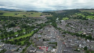
Peebles is a town in the Scottish Borders, Scotland. It was historically a royal burgh and the county town of Peeblesshire. According to the 2011 census, the population was 8,376 and the estimated population in June 2018 was 9,000.

<span class="mw-page-title-main">Peeblesshire</span> Historic county in Scotland

Peeblesshire, the County of Peebles or Tweeddale is a historic county of Scotland. Its county town is Peebles, and it borders Midlothian to the north, Selkirkshire to the east, Dumfriesshire to the south, and Lanarkshire to the west.

<span class="mw-page-title-main">Selkirkshire</span> Historic county and registration county in Scotland

Selkirkshire or the County of Selkirk is a historic county and registration county of Scotland. It borders Peeblesshire to the west, Midlothian to the north, Roxburghshire to the east, and Dumfriesshire to the south. It derives its name from its county town, the royal burgh of Selkirk. The county was historically also known as Ettrick Forest.

<span class="mw-page-title-main">Kilbucho</span> Village in Scotland

Kilbucho is a small settlement in the parish of Broughton, Glenholm and Kilbucho in the Scottish Borders area of Scotland in Peeblesshire and near Biggar and Broughton.

<span class="mw-page-title-main">Rosewell, Midlothian</span> Village in Midlothian, Scotland

Rosewell is a former mining village in Midlothian, Scotland, east of Roslin and south-west of Bonnyrigg. The village is in the civil parish of Lasswade and was previously a separate ecclesiastical parish, but has its own Community Council, namely Rosewell and District.

<span class="mw-page-title-main">Danderhall</span> Human settlement in Scotland

Danderhall is a village in Midlothian, Scotland, just outside Edinburgh but inside the Edinburgh City Bypass.

<span class="mw-page-title-main">Caddonfoot</span> Village in Scottish Borders, Scotland, UK

Caddonfoot is a village on the River Tweed, in the Scottish Borders area of Scotland, on the A707, near Galashiels.

<span class="mw-page-title-main">Cavers, Scottish Borders</span> Human settlement in Scotland

Cavers is a parish in the Scottish Borders area of Scotland, in the former county of Roxburghshire, south and east of Hawick. The largest village in the parish is Denholm.

Dolphinton is a village and parish in Lanarkshire, Scotland. It is located 7 miles (11 km) northeast of Biggar, 11 miles (18 km) northeast of Carstairs, 10 miles (16 km) southwest of Leadburn and 27 miles (43 km) southwest of Edinburgh, on the A702 road.

<span class="mw-page-title-main">Cockpen</span> Parish in Midlothian, Scotland

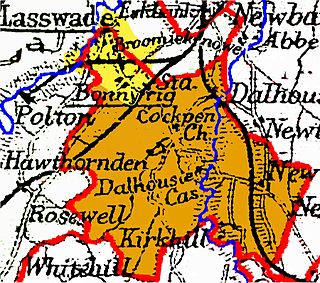
Cockpen is a parish in Midlothian, Scotland, containing at its north-west corner the town of Bonnyrigg, which lies two miles (3.2 km) south-west of Dalkeith. It is bounded on the west and north by the parish of Lasswade, on the east, by Newbattle and on the south by Carrington. It extends about three miles (4.8 km) from north to south and its greatest breadth is about 2+12 miles (4.0 km).

<span class="mw-page-title-main">Yarrow, Scottish Borders</span> Scottish parish in Scottish Borders, Scotland, UK

Yarrow is a place and parish in the Scottish Borders area of Scotland and in the former county of Selkirkshire.The name "Yarrow" may derive from the Celtic word garw meaning "rough" or possibly share a derivation with the English name "Jarrow".

<span class="mw-page-title-main">Mertoun</span> Human settlement in Scotland

Mertoun is a parish in the south-west of the historic county of Berwickshire in the Scottish Borders area of Scotland. Together with the parish of Maxton, Roxburghshire it forms the Maxton and Mertoun Community Council area. It was included in the former Ettrick and Lauderdale District of Borders Region, by the Local Government (Scotland) Act 1973, from 1975 to 1996.

Moonzie is a small parish in Fife, Scotland, about 3 miles north-west of Cupar. It is bounded on the west by Creich, on the north by Kilmany, on the south-east by Cupar and on the south-west by Monimail.

Logie is a parish and village in east Fife, Scotland, 5 miles north-east of Cupar.

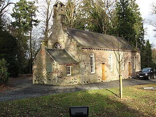
Manor is a parish in Peeblesshire in the Scottish Borders, whose church lies on the west bank of Manor Water 3 miles south-west of Peebles.

<span class="mw-page-title-main">Broughton, Glenholm and Kilbucho</span> Human settlement in Scotland

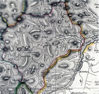
Broughton, Glenholm and Kilbucho is a parish in Peeblesshire in the Scottish Borders, 11 miles south-west of Peebles, lying in the upper part of the valley of the River Tweed in the Southern Uplands. It is a union of three former parishes of bearing these names and the united parish is bound by Kirkurd on the north, Stobo on the east, Drumelzier on the south-east, Culter and Biggar, South Lanarkshire on the west and by Skirling in the north-west. For 4½ miles the eastern border of the parish follows the northward flowing Tweed. It is 9½ miles long north-to-south and 3½ miles wide. The only village is Broughton.

<span class="mw-page-title-main">Megget</span> Human settlement in Scotland

Megget is a former chapelry or parish containing the valley of Megget Water, now forming the westernmost part of the parish of Yarrow, Selkirkshire in the Scottish Borders area of Scotland. The centre of the valley is 19 miles west of Selkirk.

<span class="mw-page-title-main">Skirling</span> Human settlement in Scotland

Skirling is a parish, community council area and village in Peeblesshire in the Scottish Borders situated 2+12 miles east of Biggar in Lanarkshire. Biggar Water, a tributary the River Tweed forms the southern boundary of the parish with the parish of Broughton, Glenholm and Kilbucho. It is also bounded by that parish on the east, namely the Broughton part of it. On the north it is bounded by the parish Kirkurd in Peeblesshire. Spittal Burn forms most of its western boundary with Lanarkshire.

<span class="mw-page-title-main">Kilfinichen and Kilvickeon</span> Civil parish on Isle of Mull, Scotland

Kilfinichen and Kilvickeon is a civil parish on the Isle of Mull in the county of Argyll, Scotland, part of the Argyll and Bute council area. It is one of three parishes on the island and extends over the south-western part and includes the islands of Iona, Erraid and Inch Kenneth. It is bordered by the parish of Torosay in the north and east. It extends about 23 miles north-east to south-west and is 18 miles wide.

<span class="mw-page-title-main">Kilninian and Kilmore</span> Civil parish on Isle of Mull, Scotland

Kilninian and Kilmore is a civil parish on the Isle of Mull in the county of Argyll, Scotland, part of the Argyll and Bute council area. It is one of three parishes on the island and extends over the north-western part. It is bordered by the parish of Torosay in the south-east. It extends about 15 miles north-west to south-east and is 13 miles wide.

References

  1. 1 2 Ordnance Gazetteer of Scotland, by Francis Groome, 2nd edition 1896; article on Kirkurd
  2. 1 2 3 Statistical Account of Scotland, Vol III Roxburgh, Peebles, Selkirk, publ.William Blackwood, 1845; article on Kirkurd (Peeblesshire section)
  3. 1 2 Third Statistical Account of Scotland: Peebles and Selkirk, Ed. James Boyd Prentice Bulloch, John Munro Urquhart; article on Kirkurd
  4. 1 2 Ordnance Survey one inch to one mile Sheet 62 - Edinburgh; Publication date 1960
  5. Canmore website of Historic Environment Scotland, formerly the Royal Commission on the Ancient and Historical Monuments of Scotland canmore.org.uk/event/709689 retrieved May 2016
  6. Peebleshire vol.2 item 476, RCAHMS
  7. Church of Scotland parish web site www.newlands-kirkurd.org/churchhistory.html retrieved May 2016
  8. Netherurd official site www.netherurd.co.uk retrieved May 2016
  9. Scottish Borders Community Council web site www.scotborders.gov.uk/directory_record/7721/lamancha_newlands_and_kirkurd retrieved May 2016
  10. Census of Scotland 2011, Table KS101SC – Usually Resident Population, publ. by National Records of Scotland. Web site http://www.scotlandscensus.gov.uk/ retrieved March 2016. See “Standard Outputs”, Table KS101SC, Area type: Civil Parish 1930
  11. Gazetteer of Scotland, publ, by W & AK Johnston, Edinburgh, 1937. Article on Kirkurd. Places are presented alphabetically