Kirton, Lincolnshire

Last updated

Kirton
SS Peter and Paul, Kirton - geograph.org.uk - 120800.jpg
Church of St Peter and St Paul, Kirton
Lincolnshire UK location map.svg
Red pog.svg
Kirton
Location within Lincolnshire
Population5,371 
OS grid reference TF304385
  London 100 mi (160 km)  S
District
Shire county
Region
Country England
Sovereign state United Kingdom
Post town BOSTON
Postcode district PE20
Dialling code 01205
Police Lincolnshire
Fire Lincolnshire
Ambulance East Midlands
UK Parliament
List of places
UK
England
Lincolnshire
52°55′40″N0°03′35″W / 52.92782°N 0.05978°W / 52.92782; -0.05978 Coordinates: 52°55′40″N0°03′35″W / 52.92782°N 0.05978°W / 52.92782; -0.05978

Kirton or Kirton in Holland is an English village and civil parish in the Borough of Boston, Lincolnshire. The population of the civil parish at the 2011 census was 5,371. [1]

Contents

History

Kirton in Holland Town Hall The Town Hall, Kirton - geograph.org.uk - 720307.jpg
Kirton in Holland Town Hall

The Domesday Book of 1086 terms the village Cherchetune. It then had 52 households, with 30 freemen and 16 smallholders, 12 ploughlands, 10 plough teams, a meadow of 60 acres (24 ha), a church and two salt houses. In 1066 lordship of the manor was held by Earl Ralph. It had passed to Count Alan of Brittany by 1086. [2] [3]

Before the local-government changes of the late 20th century, the parish came under Boston Rural District in the Parts of Holland – one of three divisions or parts of the historic county of Lincolnshire, which the Local Government Act of 1888 made a county in itself in most respects.

The 1885 Kelly's Directory recorded a Kirton railway station on the Great Northern Railway line between Boston and Spalding line. The station closed in 1961.

There existed in the 19th century Congregational and Wesleyan chapels and almshouses for four poor women. The village market was disused. A Gas Consumers' Company Ltd formed in 1865. The main landowners were the Mercers' Company, Sir Thomas Whichcote DL, E. R. C. Cust DL, the Very Rev. Arthur Percival Purey-Cust DD, and Samuel Smeeton, whose residence was the "modern white building" of D'Eyncourt Hall. The crops grown in the 8,962 acres (3,627 ha) parish were wheat, beans and potatoes. There was a "large quantity of pasture land" and 676 acres (274 ha) of marsh land. The 1881 the ecclesiastical parish population was 2,011, that of the civil parish, 2,580. [4] Kirton in Holland Town Hall was opened in August 1912. [5]

Church

The parish church is dedicated to St Peter and St Paul. [6] The transepts had double aisles like those of Algarkirk [7] and Spalding, [8] but, in 1804, the central tower and transepts were pulled down and the chancel shortened, the architect (Hayward) using gunpowder to remove the tower. This was completed by 1809. In 1900 a restoration of the rebuilt church was undertaken by the architect Hodgson Fowler. [9]

Grammar school

In 1624, Thomas (later Sir Thomas) Middlecott was empowered by a Private Act of Parliament to found a Free Grammar School for teaching the Latin and Greek languages and providing English commercial and agricultural education to children from the parishes of Kirton, Sutterton, Algarkirk and Fosdyke. By 1835, the school had 40 pupils, some attending free and some paying fees. The Master (headmaster) appointed in 1773, Rev. Charles Wildbore (c. 1736–1802), and later his son by the same name (1767–1842), were later accused of diverting surplus income from the school's endowments for their own use and failing to keep up educational standards. This culminated in a parliamentary report, and ultimately a restructuring of the school management in 1851. By 1885, William Cochran was Master and a new school house had been built next to his house. Under a scheme of the Endowed School Act , amended in 1898, the school ranked as a "second-grade" Grammar School. [4] [9] [10] [11]

In the 1830s the village gained a girls' school for 14 day and boarding pupils and a Sunday School for 32 boys and 16 girls. [11]

The village now has a secondary modern school: Thomas Middlecott Academy.

The Old King's Head

The Old King's Head is a former public house listed as a Grade II historic building. The earlier part of it was built at the end of the 16th century. It underwent major alterations in 1661 in Artisan Mannerist Style. It is red brick in English bond, with recent tiles on a former thatched roof. It became a domestic residence in the 1960s, but had fallen into disrepair and was purchased in 2016 by Heritage Lincolnshire, which has assigned over £2 million for its restoration. [12]

Geography

Kirton is on the main A16, B1397 and B1192 roads south of Boston, near Frampton and Sutterton. Several satellite villages and hamlets take their name from Kirton, including Kirton Holme, Kirton End, Kirton Fen, Kirton Skeldyke, and Kirton Marsh. Until 1970, the village had Kirton railway station on a line from Boston now closed.

Kirton Meres

Kirton Meres Gatehouse in 1893 KirtonMeresGatehouse Kirton Lincolnshire 1893.png
Kirton Meres Gatehouse in 1893

The parish contained the ancient manor of Kirton Meres, the seat of Roger de Kirton (d. 1383), alias de Kirketon / Roger de Meres / Meeres), a Justice of the Common Pleas (1371–1380). [13] The manor house (later known as "Orme Hall" [14] ) was demolished in 1818 but the arched gatehouse (Porter's Lodge, built of brick, guard room, and chambers over it, with stone dressings, windows, archway, door-ways, and copings, surmounted by highly pitched step gables, with 15 sculpted heraldic shields, some now held by the Spalding Gentlemen's Society, Broad Street, Spalding, Lincs) survived until 1925 on the south side of the Willington Road, one mile west of the village of Kirton. Another of this family resident at Kirton Meres was the churchman Francis Meres (1565-1647). [15]

Local governance

Local governance of the village was reorganised on 1 April 1974, as a result of the Local Government Act 1972. Kirton parish forms its own electoral ward.

Kirton falls within the drainage area of the Black Sluice Internal Drainage Board. [16]

Research centre

The former Kirton Research Centre was nearby. Ownership of the 120-acre (0.49 km2) centre for horticultural research was transferred from the Department for Environment, Food and Rural Affairs to the University of Warwick in April 2004 and it became part of Horticulture Research International. In August 2009 the University closed it, as public and private funding fell £2 million short of covering its annual running costs. [17]

Notable people

In order of birth:

See also

Related Research Articles

<span class="mw-page-title-main">Spalding, Lincolnshire</span> Market town in Lincolnshire, England

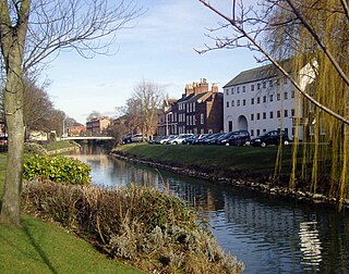
Spalding is a market town on the River Welland in the South Holland district of Lincolnshire, England. The town had a population of 31,588 at the 2011 census. The town is the administrative centre of the South Holland District. The town is located between the cities of Peterborough and Lincoln, as well as the towns of Bourne, March, Boston, Wisbech, Holbeach and Sleaford.

<span class="mw-page-title-main">Spilsby</span> Market town and civil parish in Lincolnshire, England

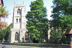
Spilsby is a market town, civil parish and electoral ward in the East Lindsey district of Lincolnshire, England. The town is adjacent to the main A16, 33 miles (53 km) east of the county town of Lincoln, 17 miles (27 km) north-east of Boston and 13 miles (21 km) north-west of Skegness. It lies at the southern edge of the Lincolnshire Wolds and north of the Fenlands, and is surrounded by scenic walking, nature reserves and other places to visit.

<span class="mw-page-title-main">Caistor</span> Town and civil parish in Lincolnshire, England

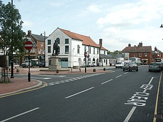
Caistor is a town and civil parish in the West Lindsey district of Lincolnshire, England. As its name implies, it was originally a Roman castrum or fortress. It lies at the north-west edge of the Lincolnshire Wolds, on the Viking Way, and just off the A46 between Lincoln and Grimsby, at the A46, A1084, A1173 and B1225 junction. It has a population of 2,601. Its name comes from the Anglo-Saxon ceaster and was given in the Domesday Book as Castre.

<span class="mw-page-title-main">Wilsford, Lincolnshire</span> Village in the North Kesteven district of Lincolnshire, England

Wilsford is a village and civil parish in the North Kesteven district of Lincolnshire, England. The population of the civil parish was 400 at the 2011 census.

<span class="mw-page-title-main">Authorpe</span> Village and civil parish in the East Lindsey district of north-west of Lincolnshire, England

Authorpe is a village and civil parish in the East Lindsey district of north-west of Lincolnshire, England. It is situated between the A16 and the A157 roads, 6 miles (10 km) south-east from Louth and 4.5 miles (7 km) north-west from Alford.

<span class="mw-page-title-main">Wyberton</span> Village in Lincolnshire, England

Wyberton is a village in Lincolnshire, England. It lies just south-west of Boston, and on the B1397 – the former A16 London Road – between Boston and Kirton. The A16 bisects the village. The population of the civil parish at the 2011 census was 3,747.

<span class="mw-page-title-main">Swineshead, Lincolnshire</span> Village and civil parish in Lincolnshire, England

Swineshead is a village and civil parish in the Borough of Boston in Lincolnshire, England. It is 7 miles (11 km) west of the town of Boston. The population of the civil parish including Baythorpe was 2,810 at the 2011 census. The parish includes the areas of Swineshead Bridge and North End to the north, Fenhouses and Blackjack to the east, and Drayton to the south.

<span class="mw-page-title-main">Sutterton</span> Village and rural parish in the Boston District of Lincolnshire, England

Sutterton is a village and rural parish in the Boston District of Lincolnshire, England. The population of the Civil Parish at the 2011 census was 1,585.

<span class="mw-page-title-main">Fosdyke</span> Village and civil parish in the Borough of Boston, Lincolnshire, England

Fosdyke is a village and civil parish in the Borough of Boston, Lincolnshire, England. The population of the civil parish at the 2011 census was 480. It is situated approximately 7 miles (11 km) south from Boston, just off the A17, and 2 miles (3.2 km) east from the junction of the A17 with the A16.

<span class="mw-page-title-main">Fishtoft</span> One of eighteen civil parishes of the Borough of Boston, Lincolnshire, England

Fishtoft is one of eighteen civil parishes which, together with Boston, form the Borough of Boston in the county of Lincolnshire, England. Local government has been arranged in this way since the reorganization of 1 April 1974, which resulted from the Local Government Act 1972. This parish forms an electoral ward in itself. Hitherto, the parish had formed part of Boston Rural District, in the Parts of Holland. Holland was one of the three divisions of the traditional county of Lincolnshire. Since the Local Government Act of 1888, Holland had been in most respects, a county in itself. The population of the civil parish at the 2011 census was 6,835.

<span class="mw-page-title-main">A16 road (England)</span> Road in Lincolnshire, England

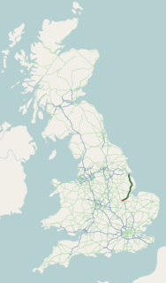
The A16 road is a principal road of Lincolnshire in the East Midlands region of England, connecting the port of Grimsby and Peterborough, where it meets the A1175, A47 & A1139 then on to the A1 and the A605; the latter, in turn, giving a through route to Northampton and the west, and south west of England. Its length is 78 miles (126 km). The road was "de-trunked", with responsibility largely returned to Lincolnshire County Council from the Highways Agency in 2002.

<span class="mw-page-title-main">Allington, Lincolnshire</span> Village in the South Kesteven district of Lincolnshire, England

Allington is a village and civil parish in the South Kesteven district of Lincolnshire, England, 3 miles (5 km) north-west of Grantham. The 2001 Census gave a parish population of 728 in 329 households. The population increased to 897 in 422 households in the 2011 census.

<span class="mw-page-title-main">Huttoft</span> Village in East Lindsey district of Lincolnshire, England

Huttoft is a village in the East Lindsey district of Lincolnshire, England, about 4 miles (6 km) east of the market town of Alford, on the A52 road between Ingoldmells and Sutton-on-Sea. John Betjeman, later England's Poet Laureate, visited Huttoft in the 1940s and devoted a poem to its parish church.

<span class="mw-page-title-main">Brothertoft</span> Village in Lincolnshire, England

Brothertoft is a village in Lincolnshire, England, about 4 miles (6.4 km) northwest from the market town of Boston. It is part of the civil parish of Holland Fen with Brothertoft.

<span class="mw-page-title-main">Mareham le Fen</span> Village in Lincolnshire, England

Mareham le Fen is a village and civil parish about 6 miles (10 km) south from the town of Horncastle, Lincolnshire, England. The hamlet of Mareham Gate lies about 0.5 miles (0.8 km) south from the village, and it is believed that the deserted medieval village (DMV) of Birkwood is situated nearby.

<span class="mw-page-title-main">Algarkirk and Sutterton railway station</span> Former railway station in Sutterton, Lincolnshire, England

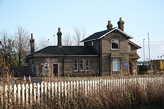
Algarkirk and Sutterton railway station was a station which served the villages of Algarkirk and Sutterton in the English county of Lincolnshire. It was served by trains on the line from Boston to Spalding.

<span class="mw-page-title-main">Gosberton Clough</span> Village in the civil parish of Gosberton and the South Holland district of Lincolnshire, England

Gosberton Clough is a village in the civil parish of Gosberton and the South Holland district of Lincolnshire, England. It is 30 miles (50 km) south-east from the city and county town of Lincoln, 5 miles (8 km) north from the nearest large town of Spalding, and 3 miles (5 km) west-southwest from parish village of Gosberton.

<span class="mw-page-title-main">Swaby</span> Village in Lincolnshire

Swaby is a civil parish and village in the East Lindsey district of Lincolnshire, England, about 8 miles (13 km) north from Spilsby, and 6 miles (9.7 km) north-west from Alford. Whitepit is a hamlet half a mile west of the village.

<span class="mw-page-title-main">Tumby, Lincolnshire</span> Village in the East Lindsey district of Lincolnshire, England

Tumby is a village in the East Lindsey district of Lincolnshire, England. It is situated approximately 2 miles (3.2 km) north from Coningsby and 6.5 miles (10.5 km) south from Horncastle, and in the civil parish of Kirkby on Bain.

References

  1. "Civil Parish population 2011". Neighbourhood Statistics. Office for National Statistics. Retrieved 21 May 2016.
  2. "Kirton" Archived 28 July 2012 at archive.today , Domesday Map. Retrieved 20 April 2012.
  3. "Documents Online: Kirton, Lincolnshire", Folio: 367v, Great Domesday Book; The National Archives. Retrieved 20 April 2012.
  4. 1 2 Kelly's Directory of Lincolnshire with the port of Hull 1885, pp. 504–505.
  5. "Timeline History of Boston". Visitoruk.com. Retrieved 20 February 2022.
  6. St Peter & St Paul's church geograph.org.uk; retrieved 23 April 2011.
  7. St Peter & St Paul's church, Algakirk, Lincs geograph.org.uk; retrieved 23 April 2011.
  8. The Church of St Mary and St Nicolas, Spalding. Retrieved 23 April 2011.
  9. 1 2 Cox, J. Charles (1916); Lincolnshire, p. 187; Methuen & Co. Ltd. Retrieved 23 April 2011.
  10. Report of the commissioners appointed in pursuance of an act of Parliament made and passed in the 5th and 6th years of King William the 4th, c. 71, intituled, "an act for appointing commissioners to continue the inquiries concerning charities in England and Wales, until the first day of March one thousand eight hundred and thirty-seven"; P. P. 1839 [194] 32 – Part IV, 38.
  11. 1 2 Great Britain. Parliament. House of Commons (1835); Parliamentary Papers, Volume 42, p. 527; BiblioBazaar, LLC (2010). ISBN   1144191092.
  12. "The Old King's Head gets a new lease of Life", heritagelincolnshire.org. Accessed 3 December 2022.
  13. Sainty, John, The Judges of England 1272 -1990: a list of judges of the superior courts, Oxford, 1993, p. 66; Foss, Judges of England: "Roger de Meres was of a Lincolnshire family, established at Kirketon in the district of Holland"; Edward Deacon, The descent of the family of Deacon of Elstowe and London, with some genealogical, biographical and topographical notes, and sketches of allied families including Reynes of Clifton, and Meres of Kirton, p. 18
  14. Earliest mention of "Orme Hall" in Marrat's "History of Lincolnshire", 1814.
  15. Kirton, Jonathan G., The Ruin at Kirton, 2013 Article by Colonel C. T. J. Moore, "Lincolnshire Notes and Queries", Vol. III, (1893), Item 140, on pp. 243 and 244; "Notes and Queries", 8th Series, Volume XII, July to December 1897, p. 47, 17 July 1897; "Oxford Journals", "Notes and Queries", 9th Series, Volume IV, July to December, 1899, p. 229 (dated 16 September 1899)
  16. "Black Sluice IDB". blacksluiceidb.gov.uk. Retrieved 3 December 2022.
  17. The Kirton Research Centre, University of Warwick.
  18. "Meares, Francis (MRS584F)". A Cambridge Alumni Database. University of Cambridge.

Media