Koarnjum

Last updated
Koarnjum
Village
Hervormde kerk, Cornjum.jpg
Koarnjum church
Map NL Ljouwerteradiel Koarnjum.png
Location in Leeuwarderadeel municipality
2010-NL-P02-Fryslan-positiekaart-gemnamen.jpg
Red pog.svg
Koarnjum
Location in the Netherlands
Netherlands location map.svg
Red pog.svg
Koarnjum
Koarnjum (Netherlands)
Coordinates: Coordinates: 53°14′36″N5°46′43″E / 53.2432°N 5.7787°E / 53.2432; 5.7787
Country Flag of the Netherlands.svg Netherlands
Province Frisian flag.svg Friesland
Municipality Flag of Leeuwarden.svg Leeuwarden
Area
[1]
  Total4.84 km2 (1.87 sq mi)
Elevation
[2]
0.2 m (0.7 ft)
Population
 (2021) [1]
  Total420
  Density87/km2 (220/sq mi)
Postal code
9056 [1]
Dialing code 058

Koarnjum (Dutch : Cornjum [3] ) is a village in the municipality of Leeuwarden (Friesland province), in the Netherlands. The village is situated between Jelsum and Britsum and a population of around 370 in January 2017. [4]

Contents

History

The village was first mentioned in 1423 as Coernem, and means "settlement of the people of Curra". [5] In 1840, it was home to 303 people. The Dutch Reformed church was built in 1873, and received a new spire in 2020. [6]

Koarnjum was served by a station on the North Friesland Railway which opened in 1901 and closed to passengers in 1930. [7] The line finally closed in 1997.

Before 2018, the village was part of the Leeuwarderadeel municipality. [6]

Notable Landmarks

The old mansion Martenastate in Koarnjum was demolished in 1899 and replaced by a small fantasy castle. [6] The stins Martenastate was originally built before 1427. In 1658, it was extensively modified. The last owner was Duco Martena van Burmania Vegelin van Claerbergen who was in financial difficulties and sold the ruinous castle to the local church in 1899 who demolished the castle and sold the land to a real estate agent. [8]

Notable people

Related Research Articles

Britsum Village in Friesland, Netherlands

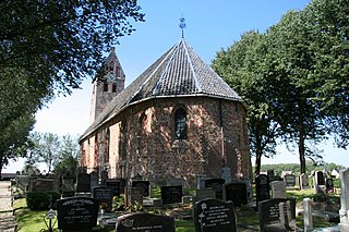
The village of Britsum is located in the municipality of Leeuwarden, in the Netherlands. Britsum was built on an artificial bank (terp) running along the eastern side of the former Middelzee. The church, built around 1300, is also located on this bank. It had a population of about 910 citizens in January 2017.

Goutum Village in Friesland, Netherlands

Goutum is a village in the municipality Leeuwarden in the province of Friesland, the Netherlands. It had a population of around 2,945 in January 2017. It is still an independent village, but is surrounded by the city of Leeuwarden on all sides.

Rijs Village in Friesland, Netherlands

Rijs is a village within the municipality of De Fryske Marren in the province of Friesland, the Netherlands.

Aldeboarn Village in Friesland, Netherlands

Aldeboarn is a village in Heerenveen in the province of Friesland, the Netherlands. It had a population of around 1545 in January 2017. Aldeboarn has an iconic church tower.

Friens Village in Friesland, Netherlands

Friens is a village in the municipality Leeuwarden in the province of Friesland, the Netherlands. It had a population of around 80 in January 2017.

Oosterzee Village in Friesland, Netherlands

Oosterzee is a village in De Fryske Marren municipality in the province of Friesland, the Netherlands. It had a population of around 915 including surrounding area in 2017.

Eesterga Village in Friesland, Netherlands

Eesterga is a small village in De Fryske Marren in the province of Friesland, the Netherlands. It had a population of around 45 in 2017.

Wergea Village in Friesland, Netherlands

Wergea is a village in Leeuwarden municipality in the province of Friesland, the Netherlands. It had a population of around 1,560 in January 2017.

Elahuizen Village in Friesland, Netherlands

Ealahuizen is a small village in De Fryske Marren municipality in the province of Friesland, the Netherlands. It is located on the banks of the Fluessen and had a population of around 345 in 2017.

Kolderwolde Village in Friesland, Netherlands

Kolderwolde is a village in De Fryske Marren municipality in the province of Friesland, the Netherlands. It had a population of around 55 in (2017).

Oudega, De Fryske Marren Village in Friesland, Netherlands

Oudega is a small village in De Fryske Marren municipality in the province of Friesland, the Netherlands. It had a population of around 265 in 2017.

Nijemirdum Village in Friesland, Netherlands

Nijemirdum is a village in De Fryske Marren municipality in the province of Friesland, the Netherlands, with a population of around 555 as of 2004.

Ruigahuizen Village in Friesland, Netherlands

Ruigahuizen is a small village in De Fryske Marren municipality in the province of Friesland, the Netherlands, south-west of Balk. It had a population of around 120 in 2017.

Oudehorne Village in Friesland, Netherlands

Oudehorne is a village in Heerenveen in the province of Friesland, the Netherlands. It had a population of around 835 in January 2017.

Terband Village in Friesland, Netherlands

Terband is a village in Heerenveen in the province of Friesland, the Netherlands. It had a population of around 270 in January 2017.

Jelsum Village in Friesland, Netherlands

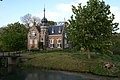
Jelsum is a village in Leeuwarden municipality in the province of Friesland, the Netherlands. It had a population of around 195 in January 2017. The stins Dekemastate is located in Jelsum.

Rottum, Friesland Village in Friesland, Netherlands

Rottum is a village in De Fryske Marren in the province of Friesland, the Netherlands. It had a population of around 675 in 2017.

Rotsterhaule Village in Friesland, Netherlands

Rotsterhaule is a village in De Fryske Marren municipality in the province of Friesland, the Netherlands. It had a population of around 565 in 2017.

Rotstergaast Village in Friesland, Netherlands

Rotstergaast is a village in Skarsterlân in De Fryske Marren municipality in the province of Friesland, the Netherlands. It had a population of around 185 in 2017.

Teroele Village in Friesland, Netherlands

Teroele is a village in De Fryske Marren in the province of Friesland, the Netherlands. It had a population of around 20 in 2017.

References

  1. 1 2 3 "Kerncijfers wijken en buurten 2021". Central Bureau of Statistics. Retrieved 30 March 2022. two entries
  2. "Postcodetool for 9056LK". Actueel Hoogtebestand Nederland (in Dutch). Het Waterschapshuis. Retrieved 30 March 2022.
  3. Taalunie (2021). "Friese namen" (in Dutch). Retrieved 11 April 2021.
  4. Kerncijfers wijken en buurten 2017 - CBS Statline
  5. "Cornjum - (geografische naam)". Etymologiebank (in Dutch). Retrieved 30 March 2022.
  6. 1 2 3 "Koarnjum". Plaatsengids (in Dutch). Retrieved 30 March 2022.
  7. "stopplaats Cornjum". Stationweb (in Dutch). Retrieved 30 March 2022.
  8. "Martena State". Stinsen in Friesland (in Dutch). Retrieved 30 March 2022.
  9. "Arend Johan van Glinstra". Netherlands Institute for Art History (in Dutch). Retrieved 30 March 2022.