
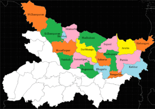
Saharsa is a city and municipal corporation in the Saharsa District in the eastern part of the state of Bihar, India. It is situated near the eastern banks of the Kosi River. It serves as the administrative headquarters for the Saharsa District and is also the Divisional headquarters of the Kosi Division.
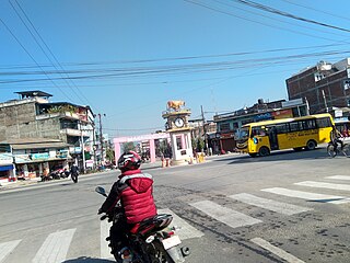
Supaul is a town and a municipality that is headquarters of Supaul district in the Indian state of Bihar. Supaul is the administrative headquarters of this district. There Are 11 block under the Supaul district Supaul, Kishanpur, Saraigarh-Bhaptiyahi, Pipra, Triveniganj, Raghopur, chhatapur, Nirmali, Marauna, Basantpur and pratapganj.

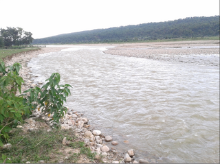
The Kosi or Koshi is a transboundary river which flows through China, Nepal and India. It drains the northern slopes of the Himalayas in Tibet and the southern slopes in Nepal. From a major confluence of tributaries north of the Chatra Gorge onwards, the Kosi River is also known as the Saptakoshi for its seven upper tributaries. These include the Tamur River originating from the Kanchenjunga area in the east and Arun River and the Sun Kosi from Tibet. The Sun Koshi's tributaries from east to west are the Dudh Koshi, Likhu Khola, Tamakoshi River, Bhote Koshi and Indravati. The Saptakoshi crosses into northern Bihar, India where it branches into distributaries before joining the Ganges near Kursela in Katihar district. The Kosi is the third-largest tributary of the Ganges by water discharge after the Ghaghara and the Yamuna.

Birpur is a city and a notified area in Supaul district in the state of Bihar, India. It is a small town on the Indo-Nepal border near the historic Koshi Barrage on the Koshi River. It has an airstrip, which is being modernised and later on will be utilized for commercial as well defence use. It had been made when first prime minister of India Jawaharlal Nehru had landed here to lay the foundation stone of Koshi Barrage. There has been a new helipad constructed next to the airstrip for multi purpose use.
Ghoghardiha is a city and a notified area in Darbhanga division, Madhubani district in the state of Bihar, India. Ghoghardiha is also a Railway Station which connects Saharsa to Laheria Sarai via Nirmali, Jhanjharpur, Lohana and Sakri.
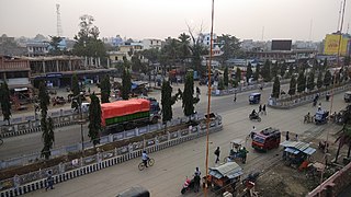
Nirmali is a town and a notified area in Supaul district in the Indian state of Bihar.
Triyuga is one of eight municipalities of Udayapur district of the Koshi Pradesh of Nepal. Gaighat is the headquarter of the municipality. At the 1991 Nepal census, it had a population of 55,291. The 2011 Nepal census counted 87,557 inhabitants. According to the 2021 Nepal census the initial population of the municipality is 104,375. It is divided into 16 wards. Triyuga Municipality was established on B.S. Chaitra 13, 2053. It was named after Triyuga River. A river which flows through the town. Triyuga is the 3rd largest municipality in Nepal and 1st largest in Koshi Pradesh in term of size (area). The total area of the municipality is 547.43 square kilometres (211.36 sq mi)
Siraha is the headquarters and municipality of Siraha District, a part of Madhesh Province, Nepal. Siraha had a population of 28,442 according to the census of 2011. and a population of 82,531 as of 2015. The current population of Siraha municipality as of census 2022, is 96,543. It has a male population of 47,306 and female population of 49,237. The present mayor of Siraha Municipality is Dr. Nabin Kumar Yadav and Deputy Mayor is Babita Kumari Sah. Both assumed office on 25 May 2022. His predecessor mayor was Asheswor Yadav and the deputy mayor was Dr. Namita Yadav. Both assumed office on 25 September 2017 and their last working day was on 24 May 2022. The town is at 80 metres (260 ft) altitude, 29 kilometres (18 mi) ESE of Janakpur.
The 2008 Indian floods were a series of floods in various states of India during the 2008 monsoon season. The floods mostly affected the western regions of Maharashtra state and Andhra Pradesh as well as northern Bihar. In India, the monsoon season generally lasts from June to September.
The 2008 Bihar flood was one of the most disastrous floods in the history of Bihar, an impoverished and densely populated state in India. The Koshi embankment near the Indo-Nepal border broke on 18 August 2008. The river changed course and flooded areas which had not been flooded in many decades. The flood affected over 2.3 million people in the northern part of Bihar.
Bihar is India's most flood-prone state, with 76% of the population of North Bihar living under the recurring threat of devastating flooding. Bihar makes up 16.5% of India's flood-affected area and contains 22.1% of India's flood-affected population. About 73.06% of Bihar's geographical area, 68,800 square kilometres (26,600 sq mi) out of 94,160 square kilometres (36,360 sq mi), is affected. Each year, floods kill many and damage livestock and other assets worth millions. In total, floods have claimed 9,500 lives since the government started publishing figures in 1979. North Bihar districts are vulnerable to at least five major flood-causing rivers during monsoon – the Mahananda, Koshi, Bagmati, Burhi Gandak, and Gandak rivers – which originate in Nepal. Some South Bihar districts have also become vulnerable to floods, from the Son, Punpun, and Phalgu rivers. The 2013 flood affected over 5.9 million people in 3,768 villages in 20 districts in the state. The 2017 flood affected 19 districts in North Bihar, killing 514 people and affecting over 17 million.
The Koshi embankments were built in late 1950s to retain the Kosi River which is a transboundary river between Nepal and India and is one of the largest tributaries of the Ganges. It was conceptualised during the first Bihar Government of CM Shri Babu and his deputy Anugraha Babu. According to the agreement with Nepal, the responsibility of maintaining these embankments was vested in the Government of Bihar.
Laukaha is a very old border town and a Community development block in the district of Madhubani in the Indian state of Bihar. It is close to the border with Nepal and the Nepalese town of Thadi. The population of Laukaha is between 11, 000 and 15, 000.
The Kamala River originates in Nepal and flows through the Indian state of Bihar.
Bhimnagar is a village in Basantpur tehsil of Supaul district in the Indian state of Bihar, south of the Koshi Barrage, near the India-Nepal border. The village has more than 20 hours power supply through Kattaiah power house. Bhimnagar is advanced in education with an 73% literacy rate. It has a Primary Hospital which is now used as Sadar Aspatal. It has been a known place for sports like cricket, Football, Badminton and many other sports. Bhimnagar was greatly impacted by the 2008 Bihar flood of the Kosi River.
North Bihar is a term used for the region of Bihar, India, which lies north of the Ganga river.

Rajbiraj Airport is a domestic airport located in Rajbiraj serving Saptari District, a district in Madhesh Province in Nepal.
Saptakosi High Dam, also called Koshi High Dam, is a multipurpose project proposed to be constructed on the Saptakoshi River of Nepal. The project is primarily aimed to control floods in south-east Nepal and northern Bihar of India, and to generate hydro power. An issue subsequently coming with this project is Nepal’s access to sea port via 165 km long navigation canal linking to Calcutta sea port through River Ganges.
Bhagwanpur is a rural municipality in Siraha District in Province No. 2 of south-eastern Nepal. At the time of the 2011 Nepal census it had a population of 20957 people living. It is located nearly 370 kilometers or 107 miles east of the capital, Kathmandu.
Thadi or Thadi Viswaspatti is a very old border town and a market place of Nepal in Siraha District bordering Indian town of Laukaha. It is currently part of Bhagwanpur Rural municipality. It is located nearly 370 kilometers or 107 miles east of the capital, Kathmandu. Thadi was part of Tirhut Rulers of Simraungarh. The region was under rule of Karnad Dynasty formed by Nanyadeva Thadi is one of the few towns which is a part of agreed route for Mutual Trade between India and Nepal. Nepal Government has set up a dedicated customs office in the town.


