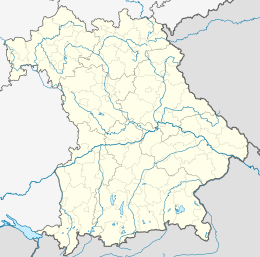
Rosenheim is a Landkreis (district) in the south of Bavaria, Germany. Neighboring districts are, clockwise from the west, Miesbach, Munich, Ebersberg, Mühldorf, and Traunstein, with the Austrian province Tirol across the southern border. The district entirely surrounds the city of Rosenheim, which is independently administered but hosts the district's administration; both the city and the district share the "RO" designation for their license plates.
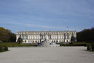
Herrenchiemsee is a complex of royal buildings on Herreninsel, the largest island in the Chiemsee lake, in southern Bavaria, Germany. Together with the neighbouring isle of Frauenchiemsee and the uninhabited Krautinsel, it forms the municipality of Chiemsee, located about 60 kilometres (37 mi) southeast of Munich.
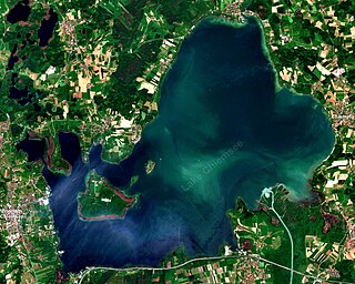
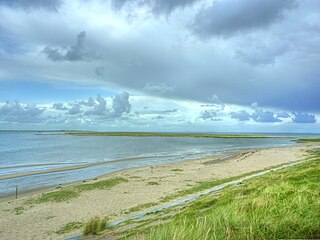
Chiemsee is a freshwater lake in Bavaria, Germany, near Rosenheim. It is often called "the Bavarian Sea". The rivers Tiroler Achen and Prien flow into the lake from the south, and the river Alz flows out towards the north. The Alz flows into the Inn which then merges with the Danube. The Chiemsee is divided into the bigger, north section, in the northeast, called Weitsee, and the Inselsee, in the southwest.

La Altagracia is the easternmost province of the Dominican Republic. Punta Cana is located on the eastern shores of this province. The province was part of the old La Altagracia Province, which split into two, La Altagracia Province and La Romana Province, on February 27, 1961.

Agsu District is one of the 66 districts of Azerbaijan. It is located in the east of the country and belongs to the Mountainous Shirvan Economic Region. The district borders the districts of Ismayilli, Shamakhi, Kurdamir, and Hajigabul. Its capital and largest city is Agsu. As of 2020, the district had a population of 81,000.

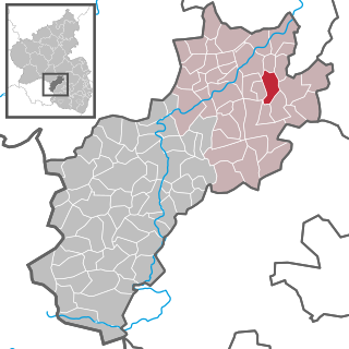
Meisburg is an Ortsgemeinde – a municipality belonging to a Verbandsgemeinde, a kind of collective municipality – in the Vulkaneifel district in Rhineland-Palatinate, Germany. It belongs to the Verbandsgemeinde of Daun, whose seat is in the like-named town. In Meisburg, a Moselle Franconian dialect is spoken.

The island Frauenchiemsee, often called Fraueninsel, is the second largest of the three islands in Chiemsee, Germany. It belongs to the municipality of Chiemsee in the Upper Bavarian district of Rosenheim, which is the smallest municipality in all of Bavaria. The 15.5-hectare (38-acre) large and car-free Fraueninsel houses a convent of Benedictine nuns, which is usually called Frauenwörth, as well as 300 permanent residents.

Chiemgau is the common name of a geographic area in Upper Bavaria. It refers to the foothills of the Alps between the rivers Inn and Traun, with the Chiemsee at its center. The political districts that contain the Chiemgau are Rosenheim and Traunstein. Wendelstein is the name of a famous mountain close by but not strictly in the Chiemgau.
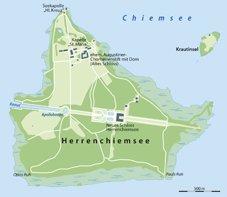
Herreninsel is a 238 hectare island in Bavaria's largest lake, Chiemsee. It is the biggest of three main islands, Fraueninsel and "Krautinsel" joining it to form the municipality of Chiemsee.

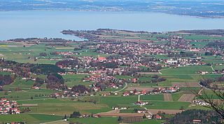
Gstadt am Chiemsee is a municipality and a village in the district of Rosenheim, Bavaria, Germany. It is located on Lake Chiemsee.
Übersee is a municipality and a village in the rural district of Traunstein in upper Bavaria, Germany. It lies on the south shore of lake Chiemsee.
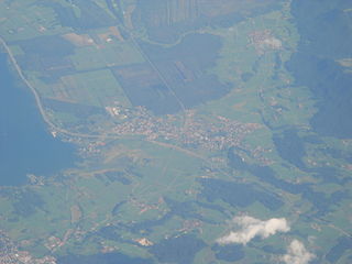
Bernau am Chiemsee is a municipality in the district of Rosenheim in Germany on the Lake Chiemsee, and a Luftkurort.

Chiemsee is a municipality in the district of Rosenheim in Bavaria in Germany, named after the lake Chiemsee. It is Bavaria's smallest municipality by area and the second smallest by population.
Hohenöllen is an Ortsgemeinde – a municipality belonging to a Verbandsgemeinde, a kind of collective municipality – in the Kusel district in Rhineland-Palatinate, Germany. It belongs to the Verbandsgemeinde Lauterecken-Wolfstein.
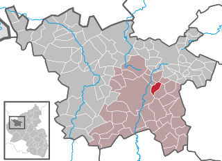
Hörscheid is an Ortsgemeinde – a municipality belonging to a Verbandsgemeinde, a kind of collective municipality – in the Vulkaneifel district in Rhineland-Palatinate, Germany. It belongs to the Verbandsgemeinde of Daun, whose seat is in the like-named town.

Katzwinkel is an Ortsgemeinde – a municipality belonging to a Verbandsgemeinde, a kind of collective municipality – in the Vulkaneifel district in Rhineland-Palatinate, Germany. It belongs to the Verbandsgemeinde of Kelberg, whose seat is in the like-named municipality.

Planura is a municipality in the west of the Brazilian state of Minas Gerais. As of 2020 the population was 12,292 in a total area of 318 km2. It became a municipality in 1962.
Uthörn is a small German island adjacent to the Sylt island in the district of Nordfriesland, and as such it is Germany's northernmost isle right after Sylt proper. It belongs to the List municipality.
Sirab is a village and municipality in the Babek District of Nakhchivan, Azerbaijan. It is located 14 km in the north-east from the district center, on the foothill area. Its population is busy with grain-growing, vegetable-growing, beekeeping and animal husbandry. There are secondary school, two library, culture house, mosque and a medical center in the village. It has a population of 2,730. The Sirab mineral water deposit is near the village.
Qaraçuq is a village and municipality in the Nakhchivan city of Nakhchivan Autonomous Republic, Azerbaijan. It is located 3 km in the south from the city center, on the plain. Its population is busy with grain-growing, horticulture, vegetable-growing, fruit-growing and animal husbandry. There are secondary school, club, library, cultural house and a medical center in the village. It has a population of 2,701.