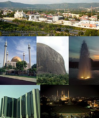
Abuja is the capital and eighth most populous city of Nigeria. Situated in the middle of the country within the Federal Capital Territory (FCT), it is a planned city built mainly in the 1980s based on a master plan by International Planning Associates (IPA), a consortium of three American planning and architecture firms made up of Wallace, Roberts, McHarg & Todd as the lead, Archi systems International, and Planning Research Corporation. The Central Business District of Abuja was designed by Japanese architect Kenzo Tange. It replaced Lagos, the country's most populous city, as the capital on 12 December 1991.
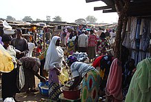
Yola, meaning 'Great Plain' or 'Vast Plain Land', is a large city, capital city and administrative centre of Adamawa State, Nigeria. It is located on the Benue River, and it has a population of over 336,648 (2010). Yola is split into two parts. The old town of Yola where the Lamido resides is the traditional city and the new city of Jimeta is the administrative and commercial centre. They are generally referred to as Yola.
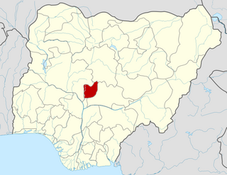
The Federal Capital Territory (FCT) is a federal territory in central Nigeria. Abuja, the capital city of Nigeria, is located in this territory. The FCT was formed in 1976 from parts of the states of old Kaduna, Kwara, Niger, and Plateau states, with the bulk of land mass carved out of Niger state. The Federal Capital Territory is within the North Central region of the country. Unlike other states of Nigeria, which are headed by elected Governors, it is administered by the Federal Capital Territory Administration, headed by a minister, who is appointed by the president.
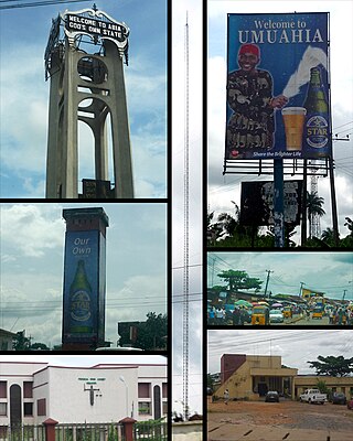
Umuahia is the capital city of Abia State in southeastern Nigeria. Umuahia is located along the rail road that lies between Port Harcourt to its south,and Enugu city to its north. Umuahia has a population of 359,230 according to the 2006 Nigerian census. Umuahia is indigenously Igbo.
Ikara is a town and local government area (LGA) in Kaduna State, northern Nigeria, located around (85km) north-east from the city of Zaria. Ikara as an LGA consists of these towns its located between 10°2¹ to 11°5¹ north and villages: Ikara, Malikachi, Furana, Danlawan, Kurmin Kogi, Janfalan, Auchan, Paki, and Pala.
Uyo is one of the local government areas and the capital city of Akwa Ibom in South South Nigeria. Ibibio is the language spoken in Uyo.
Asaba is the capital of Delta State, Nigeria. A rapidly growing city, it is located at the western bank of the Niger River, in the Oshimili South Local Government Area. Asaba had a population of 149,603 as at the 2006 census, and a fast growing metropolitan population of over half a million people.

Nasarawa State is a state in the North Central region of Nigeria, bordered to the east by the states of Taraba and Plateau, to the north by Kaduna State, to the south by the states of Benue and Kogi, and to the west by the Federal Capital Territory. Named for the historic Nasarawa Emirate, the state was formed from the west of Plateau State on 1 October 1996. The state has thirteen local government areas and its capital is Lafia, located in the east of the state, while a key economic centre of the state is the Karu Urban Area—suburbs of Abuja—along the western border with the FCT.

Kukawa is a town and Local Government Area in the northeastern Nigerian state of Borno, close to Lake Chad.
Suleja is a city in Niger State, Nigeria, pop. (2016) local government area, 260,240, just north of Abuja, capital of the Suleja Emirate. It is sometimes confused with the nearby city of Abuja, due to its proximity, and the fact that it was originally called Abuja before the Nigerian government adopted the name from the then Emir Sulayman Bal for its new federal capital in 1976.
Bida is a Local Government Area in Niger State, Nigeria and a city on the A124 highway which occupies most of the area.
Gwagwalada is a local government area in the Federal Capital Territory in Nigeria.
Kwali is a local government area in the Federal Capital Territory in Nigeria.

Ijero Ekiti is a town in Ekiti State of Nigeria in West Africa. Ijero Ekiti is situated in the northwest part of Ekiti State. Ijero Ekiti is the Local Government Headquarters of Ijero. The main language spoken by the indigenes of Ijero Ekiti is Ekiti dialect and the Yoruba language.
Gubio, also Gobiyo, is a Local Government Area of Borno State, in northeastern Nigeria. Its headquarters are in the town of Gubio.

Nkwerre is one of the Local Government Areas in Imo State, South-East, Nigeria. It is situated in Nkwerre town where the name of the local government area was derived. Its population was placed at 80,270 from the 2006 population census with an area of 38.447 km. It is known for its thick vegetation which is supposed to prevent soil erosion however, it is erosion prone area.
Karu is a Local Government Area in Nasarawa State, central Nigeria. It is close in proximity to the Federal Capital Territory of Nigeria. It has an area of 2,640 km2. Karu local government has its headquarters in New Karu town. It was originally built to house the capital's civil servants and lower income families, but had no running water or good sanitation system. Karu has grown in population beyond its original planned capacity. Ensure Administrative convenience and bring government closer to the grass root people, Karshi Development Area was created with its administrative secretariat at Uke.
Lapai is a Local Government Area in Niger State, Nigeria, adjoining the Federal Capital Territory. Its headquarters are in the town of Lapai on the A124 highway in the west of the area at 9°03′00″N6°34′00″E.
Bwari is a local government area in the Federal Capital Territory in Nigeria. The original inhabitants of the town are the Gbagyi speaking people. The paramount ruler is the Esu who is otherwise known as Sa-bwaya. However, with the establishment of FCT in Abuja so many changes occurred; such changes include the turbaning of late Musa Ijakoro as District Head of Bwari in 1976, and his elevation as Sarki of Bwari to the position of a second class status in 1997 by the Ministry of the Federal Capital Territory under the then minister, General Jeremiah Useni.
Abaji is a local government area in the Federal Capital Territory of Nigeria, Abuja. The Abaji Area Council is the area council farthest from the city center and occupies approximately 1,100 square kilometers. Created in 1986, the council has a population of over 46,600 inhabitants according to a 2006 national census. As a gateway to the Federal Capital Territory (FCT), Abaji is a fast-growing area. There is a notable influx of arrivals, many moving in search of new means of livelihood.