A communications satellite is an artificial satellite that relays and amplifies radio telecommunication signals via a transponder; it creates a communication channel between a source transmitter and a receiver at different locations on Earth. Communications satellites are used for television, telephone, radio, internet, and military applications. Many communications satellites are in geostationary orbit 22,236 miles (35,785 km) above the equator, so that the satellite appears stationary at the same point in the sky; therefore the satellite dish antennas of ground stations can be aimed permanently at that spot and do not have to move to track the satellite. Others form satellite constellations in low Earth orbit, where antennas on the ground have to follow the position of the satellites and switch between satellites frequently.

Ulysses was a robotic space probe whose primary mission was to orbit the Sun and study it at all latitudes. It was launched in 1990 and made three "fast latitude scans" of the Sun in 1994/1995, 2000/2001, and 2007/2008. In addition, the probe studied several comets. Ulysses was a joint venture of the European Space Agency (ESA) and the United States' National Aeronautics and Space Administration (NASA), under leadership of ESA with participation from Canada's National Research Council. The last day for mission operations on Ulysses was 30 June 2009.

Teledesic was a company founded in the 1990s to build a commercial broadband satellite internet constellation. Using low-Earth-orbiting satellites small antennas could be used to provide uplinks of as much as 100 Mbit/s and downlinks of up to 720 Mbit/s. The original 1994 proposal was extremely ambitious, costing over 9 billion USD and originally planning 840 active satellites with in-orbit spares at an altitude of 700 km. In 1997, the plan was scaled back to 288 active satellites at 1400 km. Teledesic Corporation changed its name to Teledesic, LLC by pro forma assignment of its license, granted on 26 January 1998.

The NASA Deep Space Network (DSN) is a worldwide network of spacecraft communication ground segment facilities, located in the United States (California), Spain (Madrid), and Australia (Canberra), that supports NASA's interplanetary spacecraft missions. It also performs radio and radar astronomy observations for the exploration of the Solar System and the universe, and supports selected Earth-orbiting missions. DSN is part of the NASA Jet Propulsion Laboratory (JPL).

The Goldstone Deep Space Communications Complex (GDSCC), commonly called the Goldstone Observatory, is a satellite ground station located in Fort Irwin in the U.S. state of California. Operated by NASA's Jet Propulsion Laboratory (JPL), its main purpose is to track and communicate with interplanetary space missions. It is named after Goldstone, California, a nearby gold-mining ghost town.

New Norcia Station is an ESTRACK Earth station in Australia for communication with spacecraft after launch, in low Earth orbit, in geostationary orbit and in deep space. It is located 10 kilometres (6.2 mi) south of the town of New Norcia, Western Australia. It was the first ESA deep space ground station, followed by Cebreros Station and Malargüe Station.
The Communications Technology Satellite (CTS), known as Hermes, was an experimental high-power direct broadcast communications satellite. It was a joint effort of Canadian Department of Communications, who designed and built the satellite, NASA who tested, launched and operated the satellite, and European Space Agency (ESA) who provided the 1200 watts solar panels and other devices. The three agencies shared the satellite and the data from the experiments.

Project Echo was the first passive communications satellite experiment. Each of the two American spacecraft, launched in 1960 and 1964, were metalized balloon satellites acting as passive reflectors of microwave signals. Communication signals were transmitted from one location on Earth and bounced off the surface of the satellite to another Earth location.

Milstar is a constellation of military communications satellites in geosynchronous orbit, which are operated by the United States Space Force, and provide secure and jam-resistant worldwide communications to meet the requirements of the Armed Forces of the United States. Six spacecraft were launched between 1994 and 2003, of which only five were operational after launch; the third launch failed, both damaging the satellite and leaving it in an unusable orbit.

Maspalomas Station is an INTA-operated, ESTRACK radio antenna ground station for communication with spacecraft located at the southern area of Gran Canaria island, on the INTA campus. It is situated on the Montaña Blanca hill and is visible from the coastal resort of Meloneras, close to Maspalomas. It was originally established in the 1960s to support NASA's nascent human spaceflight program.

Advanced Extremely High Frequency (AEHF) is a constellation of communications satellites operated by the United States Space Force. They are used to relay secure communications for the United States Armed Forces, the British Armed Forces, the Canadian Armed Forces, the Netherlands Armed Forces and the Australian Defence Force. The system consists of six satellites in geostationary orbits. The final satellite was launched on 26 March 2020. AEHF is backward compatible with, and replaces, the older Milstar system and will operate at 44 GHz uplink and 20 GHz downlink. The AEHF system is a joint service communications system that provides survivable, global, secure, protected, and jam-resistant communications for high-priority military ground, sea and air assets.

The Lincoln Experimental Satellite series was designed and built by Lincoln Laboratory at Massachusetts Institute of Technology between 1965 and 1976, under USAF sponsorship, for testing devices and techniques for satellite communication.
The Intelsat VI series of satellites were the 8th generation of geostationary communications satellites for the Intelsat Corporation. Designed and built by Hughes Aircraft Company (HAC) in 1983-1991, there were five VI-series satellites built: 601, 602, 603, 604, and 605.
The Unified S-band (USB) system is a tracking and communication system developed for the Apollo program by NASA and the Jet Propulsion Laboratory (JPL). It operated in the S band portion of the microwave spectrum, unifying voice communications, television, telemetry, command, tracking and ranging into a single system to save size and weight and simplify operations. The USB ground network was managed by the Goddard Space Flight Center (GSFC). Commercial contractors included Collins Radio, Blaw-Knox, Motorola and Energy Systems.

The Deep Space Atomic Clock (DSAC) was a miniaturized, ultra-precise mercury-ion atomic clock for precise radio navigation in deep space. DSAC was designed to be orders of magnitude more stable than existing navigation clocks, with a drift of no more than 1 nanosecond in 10 days. It is expected that a DSAC would incur no more than 1 microsecond of error in 10 years of operations. Data from DSAC is expected to improve the precision of deep space navigation, and enable more efficient use of tracking networks. The project was managed by NASA's Jet Propulsion Laboratory and it was deployed as part of the U.S. Air Force's Space Test Program 2 (STP-2) mission aboard a SpaceX Falcon Heavy rocket on 25 June 2019.
A zombie satellite is a satellite that begins communicating again after an extended period of inactivity. It is a type of space debris, which describes all defunct human-made objects in outer space. At the end of their service life, the majority of satellites suffer from orbital decay and are destroyed by the heat of atmospheric entry. Zombie satellites, however, maintain a stable orbit but are either partially or completely inoperable, preventing operators from communicating with them consistently.

Lincoln Experimental Satellite 2, also known as LES-2, was a communications satellite, the second of nine in the Lincoln Experimental Satellite. Launched by the United States Air Force (USAF) on 6 May 1965, it demonstrated many then-advanced technologies including active use of the military's SHF band to service hundreds of users.

Lincoln Experimental Satellite 3, also known as LES-3, was a communications satellite, the third of nine in the Lincoln Experimental Satellite. Launched by the United States Air Force (USAF) on 21 Dec 1965, it was stranded in a Geostationary Transfer Orbit rather than its planned circular high orbit. Despite this, LES-3 returned good data on communications propagation in the UHF band.

Lincoln Experimental Satellite 4, also known as LES-4, was a communications satellite, the fourth of nine in the Lincoln Experimental Satellite, and the first of the series designed for operations at geosynchronous altitudes. Launched by the United States Air Force (USAF) on 21 December 1965, it demonstrated many then-advanced technologies including active use of the military's SHF band to service hundreds of users.

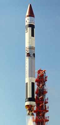
The Initial Defense Communications Satellite Program or IDCSP was the first United States Department of Defense communications satellite constellation and the first stage of the Defense Communications Satellite Program (DCSP). Launched in five groups by Titan IIIC launch vehicles to near equatorial, subsynchronous orbits between 1966 and 1968, they were intended to be experimental testbeds. They were so successful that, by the time of the launch of the last set of eight satellites, the IDCSP was deemed operational and renamed Initial Defense Satellite Communications System or IDSCS. This system allowed real-time collection of battlefield intelligence during the Vietnam War. A total of 35 IDCSP satellites were launched, 27 successfully.